When you’re submitting a planning application, whether it’s a residential development, commercial extension, or infrastructure project, one phrase you’ll encounter again and again is highway traffic control. It’s more than a tick-box exercise. It’s a critical framework that determines whether your scheme can safely manage vehicle and pedestrian movement during construction and once it’s operational. Get it wrong, and you risk refusal, expensive mitigation demands, or approval conditions that hobble your project. This article explains what highway traffic control actually involves, breaks down the core systems and components, and shows how it’s assessed in transport statements and transport assessments, the documents your local authority will scrutinise closely before granting consent.
Key Takeaways
- Highway traffic control is a critical framework combining devices, rules, and operations that determines whether developments can safely manage vehicle and pedestrian movement during construction and operation.
- Comprehensive highway traffic control systems comprise multiple layers including traffic signs and signals, road markings, barricades, traffic control personnel, and intelligent transport systems that work together to minimise conflicts.
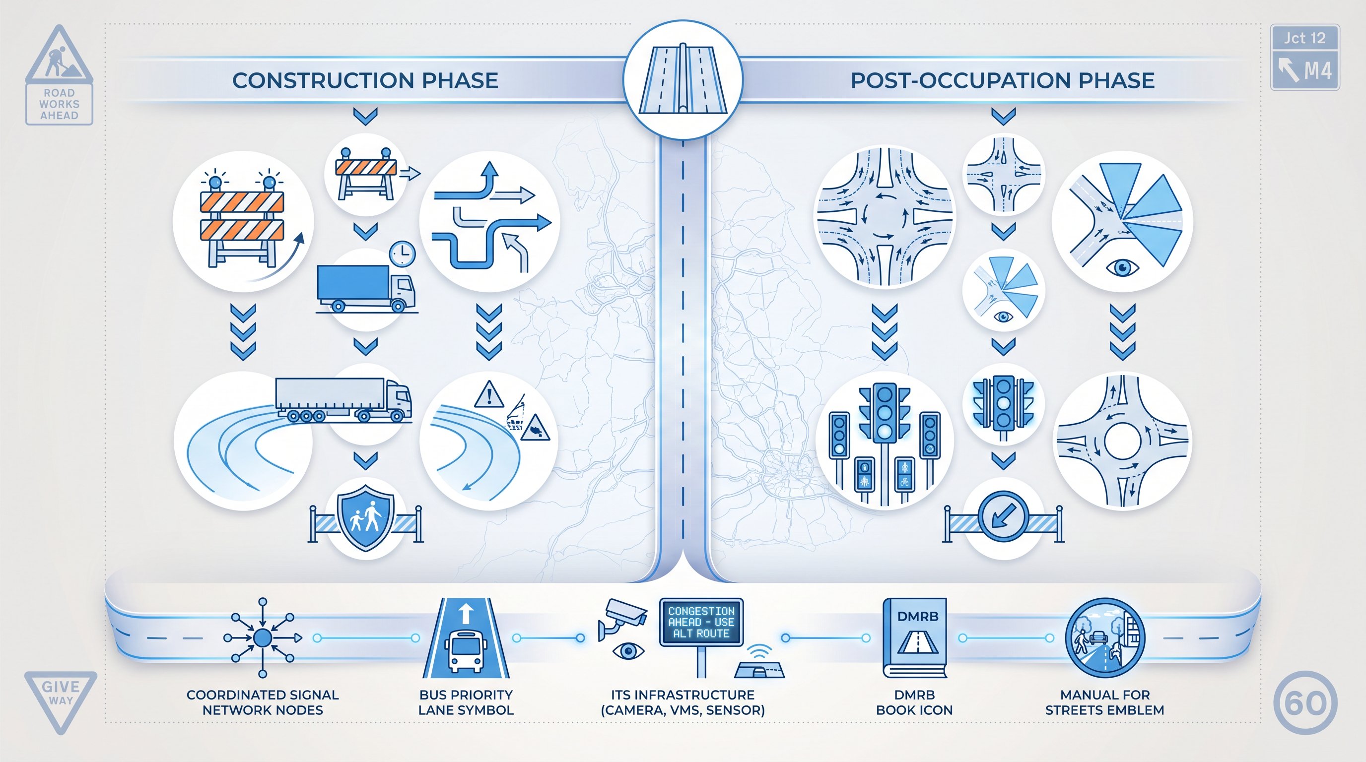
- Transport assessments must demonstrate how traffic will be managed safely and efficiently both during construction (via temporary measures and Construction Traffic Management Plans) and post-occupation (via permanent infrastructure design).
- Signal coordination and phasing at junctions must be modelled using specialist software to ensure developments don’t exceed capacity, with developers often required to show both existing and optimised layouts.
- Compliance with design standards such as the Design Manual for Roads and Bridges, Traffic Signs Regulations 2016, and local authority design guides strengthens planning applications and reduces the risk of refusal or expensive mitigation demands.
- Local authorities increasingly expect developers to contribute to or upgrade intelligent transport systems infrastructure, variable message signs, and traffic monitoring equipment where schemes generate strategic-level impacts.
What Is Highway Traffic Control?
At its simplest, highway traffic control is the combination of devices, rules, and operations used to manage the movement of vehicles and pedestrians on roads and highways. The objective is threefold: improve safety, boost efficiency, and maintain smooth traffic flow, even when conditions change.
In practice, this covers both permanent infrastructure (traffic lights, road markings, fixed signs) and temporary measures (site access controls during construction, diversions, barriers around work zones). The system is underpinned by legislation and design standards, including the Traffic Signs Regulations and General Directions 2016 (TSRGD) and guidance from the Department for Transport.
When a development is proposed, highway traffic control measures are scrutinised as part of the planning process. Local authorities, and often the statutory highway authority, want to see evidence that road users will be protected, that existing junctions won’t be overwhelmed, and that temporary disruption during construction will be contained. This is where transport assessments and construction traffic management plans become vital.
For planners and developers, understanding highway traffic control isn’t optional. It informs site layout, access design, phasing strategies, and the content of supporting documents. It also shapes discussions with highways officers and can be the difference between straightforward approval and protracted negotiation.
Key Components of Highway Traffic Control Systems
A comprehensive highway traffic control system comprises multiple layers, each addressing a different aspect of road user behaviour and safety. These elements work together to create a predictable, legible environment where conflicts are minimised and compliance is high.
Traffic signs and signals are the most visible components. They communicate regulatory instructions (speed limits, no entry), warnings (sharp bends, pedestrian crossings ahead), and directional information. Signals, whether at junctions, pedestrian crossings, or variable message signs, add dynamic control, responding to real-time demand or scheduled timing plans.
Road markings include lane lines, stop bars, hatching, and cycle lane demarcation. They guide positioning, indicate where stopping or overtaking is prohibited, and delineate zones for different user groups. In work zones, markings are often supplemented by temporary cones, delineators, and coloured surfacing to channel traffic safely past hazards.
Barricades and barriers separate traffic from construction sites, roadworks, and other temporary or permanent hazards. Water-filled barriers, Armco, and pedestrian guardrails all fall into this category, and their specification must comply with standards such as Chapter 8 of the Traffic Signs Manual.
Traffic control personnel, often flaggers or trained marshals, direct flow where signals or signs alone can’t manage complexity or risk. They’re common on construction sites with restricted sightlines or where vehicles must reverse onto the highway.
Finally, technology and intelligent transport systems (ITS) enable centralised monitoring and adaptive control. Urban traffic control (UTC) software coordinates signals across networks, while CCTV, incident detection, and variable message signs allow operators to respond quickly to congestion, collisions, or breakdowns. Increasingly, local authorities expect developers to demonstrate how their schemes interact with, or contribute to, these wider systems, especially for larger sites that generate significant traffic.
Traffic Signal Coordination and Phasing
Signal coordination is the process of linking multiple junctions so that vehicles travelling along a corridor encounter fewer red lights and smoother progression. This is achieved by setting offsets between signals based on average travel time, traffic speed, and distance. When done well, it reduces stops, lowers emissions, and improves journey time reliability, all metrics that matter in transport assessments.
Phasing, by contrast, refers to the sequence and duration of green, amber, and red stages at a single junction. A typical four-arm crossroads might have two or three phases, each allowing certain movements while holding back conflicting streams. More complex junctions, especially those with pedestrian crossings, cycle phases, or bus priority, can have four or more phases.
Getting phasing right is essential for both capacity and safety. Too short a green time and queues build: too long and minor arms suffer excessive delay. Highway and traffic engineering specialists use junction modelling software, LINSIG, VISSIM, or similar, to test different phasing strategies and demonstrate that a proposed development won’t tip a junction over capacity.
For planning applications, you’ll often need to model both the existing phasing and a proposed optimised layout, showing how signal timings can be adjusted (or whether physical improvements are required) to accommodate additional demand.
Highway Signage and Road Markings
Signs and markings are the grammar of the road. They establish expectations, warn of hazards, and guide decision-making, often in fractions of a second.
Regulatory signs (mandatory speed limits, no waiting, one-way) carry legal force: ignoring them is an offence. Warning signs alert drivers to upcoming hazards, bends, junctions, school zones, and are positioned based on approach speed and stopping sight distance. Directional signs help unfamiliar users navigate, which is particularly important where new developments introduce junctions or roundabouts onto existing roads.
Road markings perform similar functions but do so continuously. Centre lines prevent head-on collisions: edge lines define the carriageway: hatching protects ghost islands and turning lanes. In urban settings, markings also delineate cycle lanes, bus lanes, and loading bays, all of which must be factored into site access design.
Temporary signs and markings are equally important during construction. Chapter 8 layouts dictate how works should be signed and guarded, with prescribed sequences for advance warning, taper lengths, and lane closures. Developers are typically required to submit a traffic management plan showing compliance with these standards before works begin, and highway authorities can (and do) inspect sites to ensure adherence.
Highway Traffic Control in Transport Assessments
When you’re preparing a transport assessment (TA) or transport statement (TS) for a planning application, highway traffic control isn’t just background context, it’s a central theme. The document must demonstrate how traffic will be managed safely and efficiently both during construction and once the development is occupied.
During the construction phase, the focus is on temporary traffic control. You’ll need to outline site access arrangements, delivery routes, vehicle types and frequencies, hours of operation, and measures to protect pedestrians and cyclists. Larger schemes often require a Construction Traffic Management Plan (CTMP) as a planning condition, detailing swept path analyses for HGVs, wheel-washing facilities, banksmen protocols, and liaison with the highway authority.
Post-occupation, the assessment shifts to permanent highway traffic control measures. This includes showing that new junctions or accesses have adequate visibility splays, that turning movements can be accommodated without blocking through traffic, and that any proposed signals or roundabouts are appropriately designed and phased. If your development increases traffic at existing junctions, you may need to model whether signal timings can be optimised or whether physical mitigation, widening, additional lanes, pedestrian phases, is necessary.
Transport assessments also consider how your scheme interacts with wider highway traffic control networks. Will your traffic affect coordinated signal corridors? Does your site rely on bus priority measures or cycle infrastructure that must be maintained? Are there cumulative impacts from other consented developments that need factoring in?
Local authorities increasingly expect developers to contribute to or upgrade ITS infrastructure, variable message signs, CCTV, traffic monitoring equipment, especially where schemes generate strategic-level impacts. This is often secured through Section 106 agreements or Section 278 works.
Finally, the TA should address compliance with relevant design standards: the Design Manual for Roads and Bridges (DMRB) for trunk roads, local highway authority design guides, and Manual for Streets for urban contexts. Demonstrating that your highway traffic control measures meet or exceed these benchmarks strengthens the application and reduces the risk of objections or costly late-stage changes.
Conclusion
Highway traffic control is the connective tissue between your development and the public highway network. Whether you’re managing construction logistics or designing permanent access, the principles remain the same: safety, efficiency, and compliance with recognised standards. For architects, planners, and developers, getting this right early, and presenting it clearly in your transport assessment, will smooth the path to planning consent and reduce the risk of expensive mitigation down the line.
Frequently Asked Questions About Highway Traffic Control
What is highway traffic control and why does it matter for planning applications?
Highway traffic control comprises devices, rules, and operations that manage vehicle and pedestrian movement to improve safety, efficiency, and traffic flow. For planning applications, it’s critical because it demonstrates to local authorities that your development won’t overwhelm existing junctions, will protect road users during construction, and complies with recognised design standards.
What are the main components of a highway traffic control system?
Key components include traffic signs and signals (communicating rules and directions), road markings (lane lines and crosswalks), barricades and barriers (protecting hazards), traffic control personnel (flaggers and marshals), and technology systems like UTC software and CCTV. Together, these create a predictable environment that minimises conflicts and improves compliance.
How do signal coordination and phasing affect traffic flow at junctions?
Signal coordination links multiple junctions so vehicles encounter fewer red lights along a corridor, reducing stops and emissions. Phasing controls the sequence and timing of movements at a single junction, separating conflicting traffic streams. Proper phasing reduces queues and improves capacity, which is essential when assessing development impacts.
What information about highway traffic control must be included in a transport assessment?
Transport assessments must detail how traffic will be managed during construction (site access, delivery routes, protective measures) and post-occupation (junction visibility, signal timing, any required mitigation). For significant schemes, a Construction Traffic Management Plan showing swept path analyses and compliance with design standards is typically required as a planning condition.
Do highway traffic control measures differ between construction and permanent operations?
Yes. During construction, temporary measures such as site access controls, diversions, and barriers protect workers and nearby residents. Permanent measures focus on new junctions, access visibility, and integration with existing signal networks. Both must comply with relevant design standards and be assessed in planning documentation.
How can specialists help demonstrate compliance with highway traffic control standards?
Highway and traffic engineering consultants use junction modelling software, swept path analyses, and design guidance to show how your development will meet safety and capacity benchmarks. Their expertise strengthens applications, reduces objections, and helps secure planning consent without costly late-stage changes.