A planning application can look perfectly sensible on paper and still stall because the junction doesn’t work. That’s the uncomfortable truth in 2026. Local highway authorities are under pressure to scrutinise safety, active travel, servicing, drainage and network impact more closely than ever, and junction and access design sits right in the middle of all of it.
For architects, planners, developers and councils, this isn’t just a technical appendix issue. It affects whether a site can be accessed safely, whether queues will form back onto the network, whether refuse vehicles can turn, and whether people walking or cycling are being squeezed out by a geometry-led layout. In practice, a weak access concept often causes expensive redesign late in the process.
We’ve seen that the strongest schemes start with a realistic view of how a development connects to its surroundings, then build the transport evidence around that. Good junction and access design is rarely flashy. It’s clear, proportionate and defensible. And that matters when a planning officer, highway consultee or appeal inspector asks the obvious question: does this arrangement actually work?
In this guide, we’ll unpack what decision-makers typically need to get right, where applications most often slip, and how a robust design approach supports transport assessments and planning statements from the outset.
What Junction And Access Design Means In The Planning Process
Junction and access design is the way roads, accesses and movement routes are arranged so a development connects safely and efficiently to the existing highway network. In planning terms, that usually begins at concept or masterplan stage, long before kerb lines, surfacing and drainage details are fully fixed.
At this point, we’re not just drawing an entrance. We’re testing whether the site can accommodate the right form of junction, whether visibility is achievable, whether vehicles can enter and leave sensibly, and whether the proposal aligns with local highway guidance and national design principles such as Manual for Streets.
This is why junction design often sits alongside site promotion, pre-app discussion and transport scoping. It informs red-line layout decisions, frontage treatment, parking arrangement and the amount of developable area that is truly realistic.
A planning-ready scheme usually shows more than a point of access. It demonstrates how drivers, pedestrians, cyclists, service vehicles and emergency vehicles interact with that access. In many cases, a wider junction and access design strategy also helps frame the Transport Statement or Transport Assessment, because the geometry and operation of the access directly influence safety and capacity conclusions.
Why It Matters For Safety, Capacity, And Planning Approval
Highway authorities focus on junctions because that’s where conflict happens. Speeds change, paths cross, drivers make decisions quickly, and vulnerable road users are often exposed to turning traffic. If the geometry is unclear or the visibility is weak, collision risk increases. That alone can be enough to trigger objections.
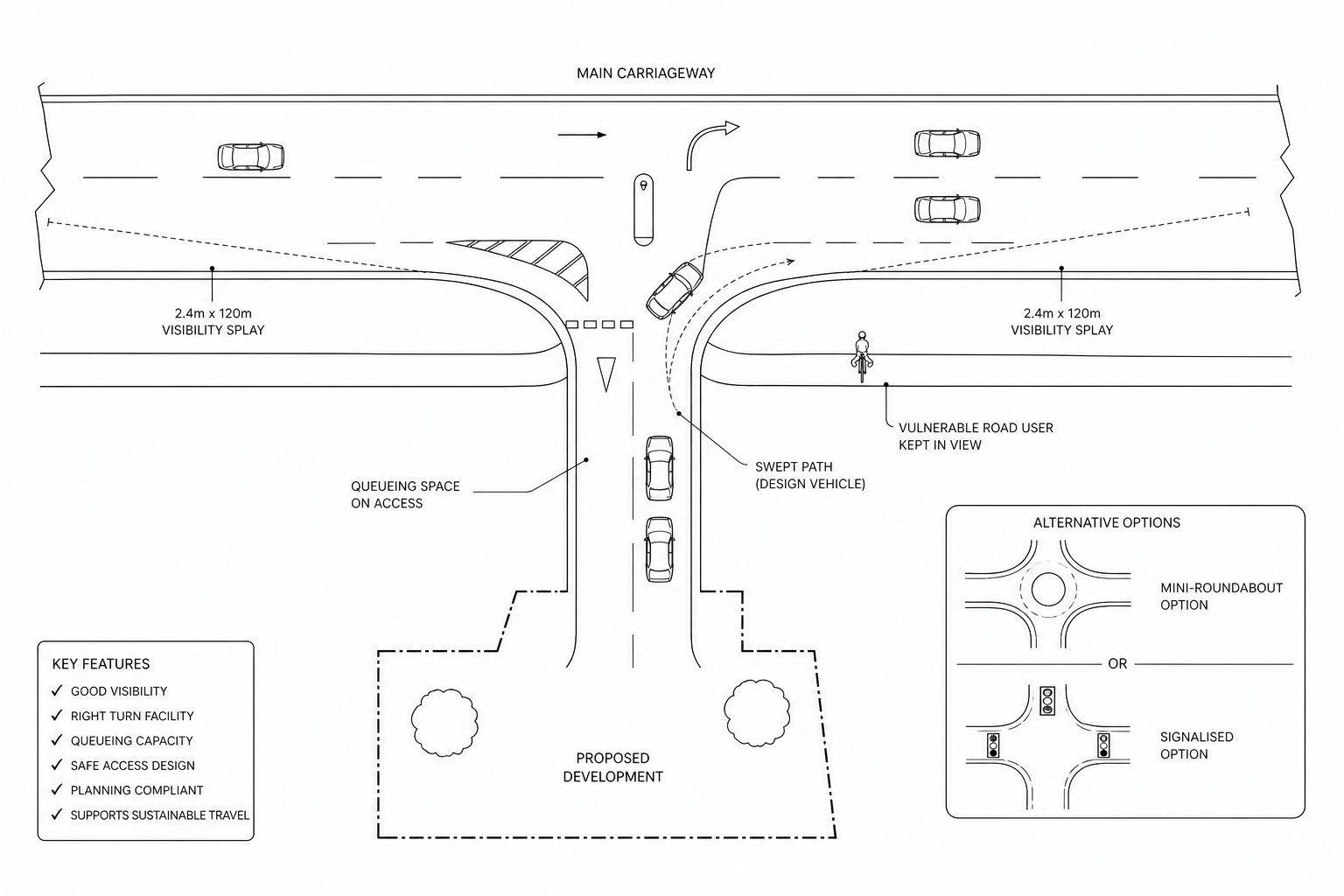
Capacity matters too. Even a modest development can create practical issues if the access causes turning delays, right-turn blocking, or queues extending onto a strategic route. For larger sites, the question becomes whether a priority junction is still appropriate or whether a mini-roundabout, ghost island, compact roundabout or signals are needed.
Planning approval often turns on whether the transport evidence is credible. A junction that appears workable in principle but lacks proper visibility splays, swept path analysis or capacity evidence can leave officers with little confidence. And when confidence drops, requests for further information multiply.
That’s why robust access design is not separate from planning strategy. It is planning strategy. Teams producing Access Strategy Transport Planning: material early tend to be in a stronger position, because they can show the access is safe, suitable and proportionate to the scale of development rather than trying to defend a weak layout later.
Core Design Principles That Shape A Robust Scheme
A robust scheme normally starts with a few basics done properly: clear priority, legible geometry, sensible spacing from nearby junctions and accesses, and dimensions that reflect the vehicles and users who will actually be there. Very often, that points towards a simple, near right-angled T-junction because it is intuitive and helps visibility.
But robust doesn’t mean over-designed. Oversized radii can encourage faster turns. Excessive width can create longer pedestrian crossings. Too many accesses along a frontage can weaken both safety and network function. The aim is to create a layout that reads clearly to all users without creating unnecessary conflict.
Designers also need to think in three dimensions, not just in plan. Horizontal alignment, vertical profile, verge treatment, boundary features and street clutter all influence whether the access works in reality. A good drawing can still fail on site if level differences, walls, planting or signs compromise sightlines.
The practical benchmark is simple: can we explain, with evidence, why the junction geometry is suitable for the site, the speed environment and the expected users? If not, the design probably needs more work.
Visibility, Speed, And User Behaviour
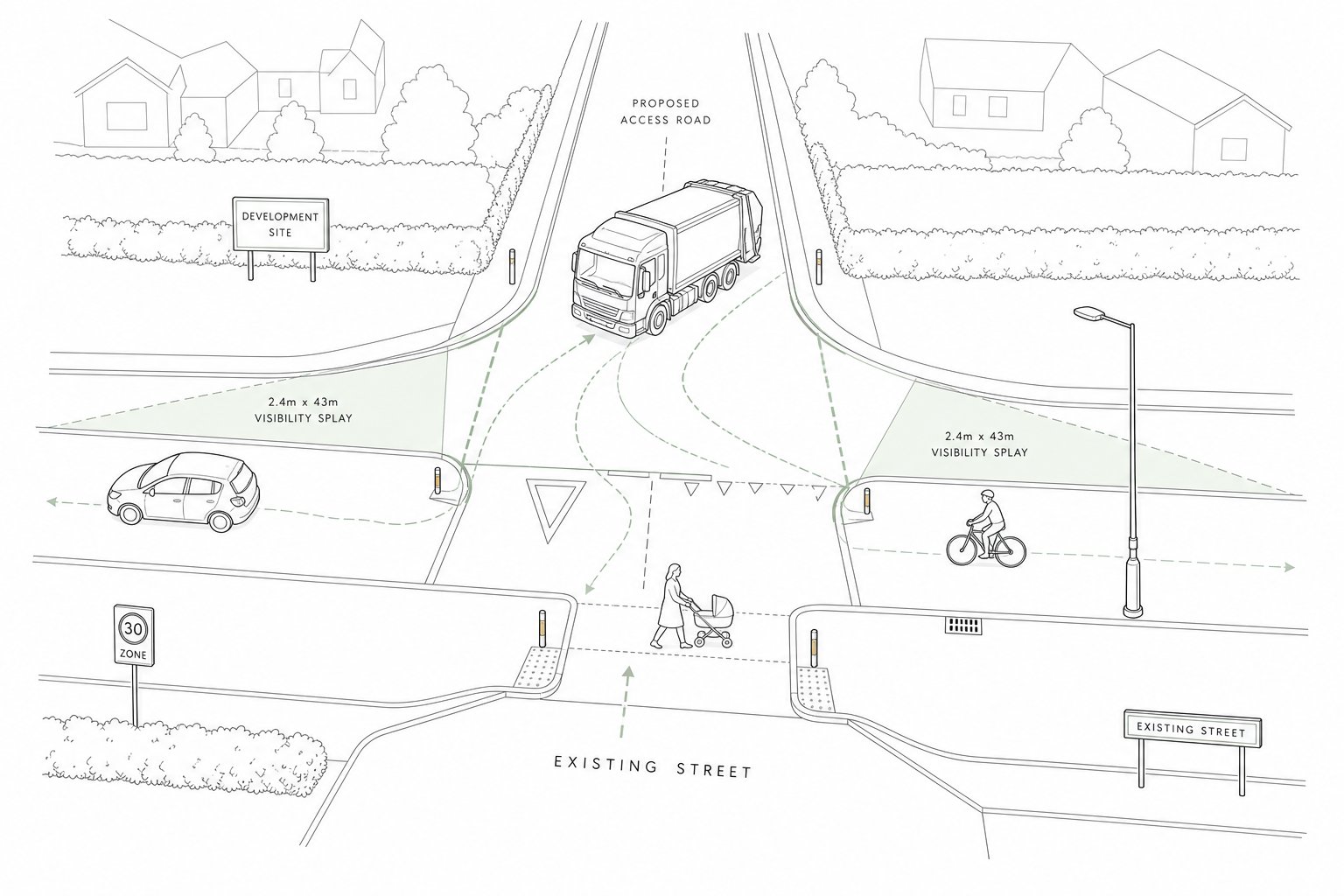
Visibility splays remain one of the first things a reviewing officer will test. They need to be based on the appropriate X and Y distances, measured correctly, and kept clear at driver eye height. On higher-speed roads, that requirement can become the defining constraint on whether access is feasible at all.
Just as important is how the layout influences speed and behaviour. Junctions positioned on a crest can undermine sightlines: approaches on level or sag alignment are typically more dependable. Geometry can also be used to moderate speed. Narrower entries, tighter deflection where appropriate, raised tables and other physical cues help shape driver behaviour rather than relying on signs alone.
We should never assume users behave ideally. Drivers edge forward. Cyclists may take a primary position. Vans swing wide. Parents cross with buggies at awkward angles. Good design anticipates those ordinary behaviours and reduces the consequences when people are imperfect, which, frankly, they always are.
Vehicle Tracking, Turning Movements, And Swept Path Needs
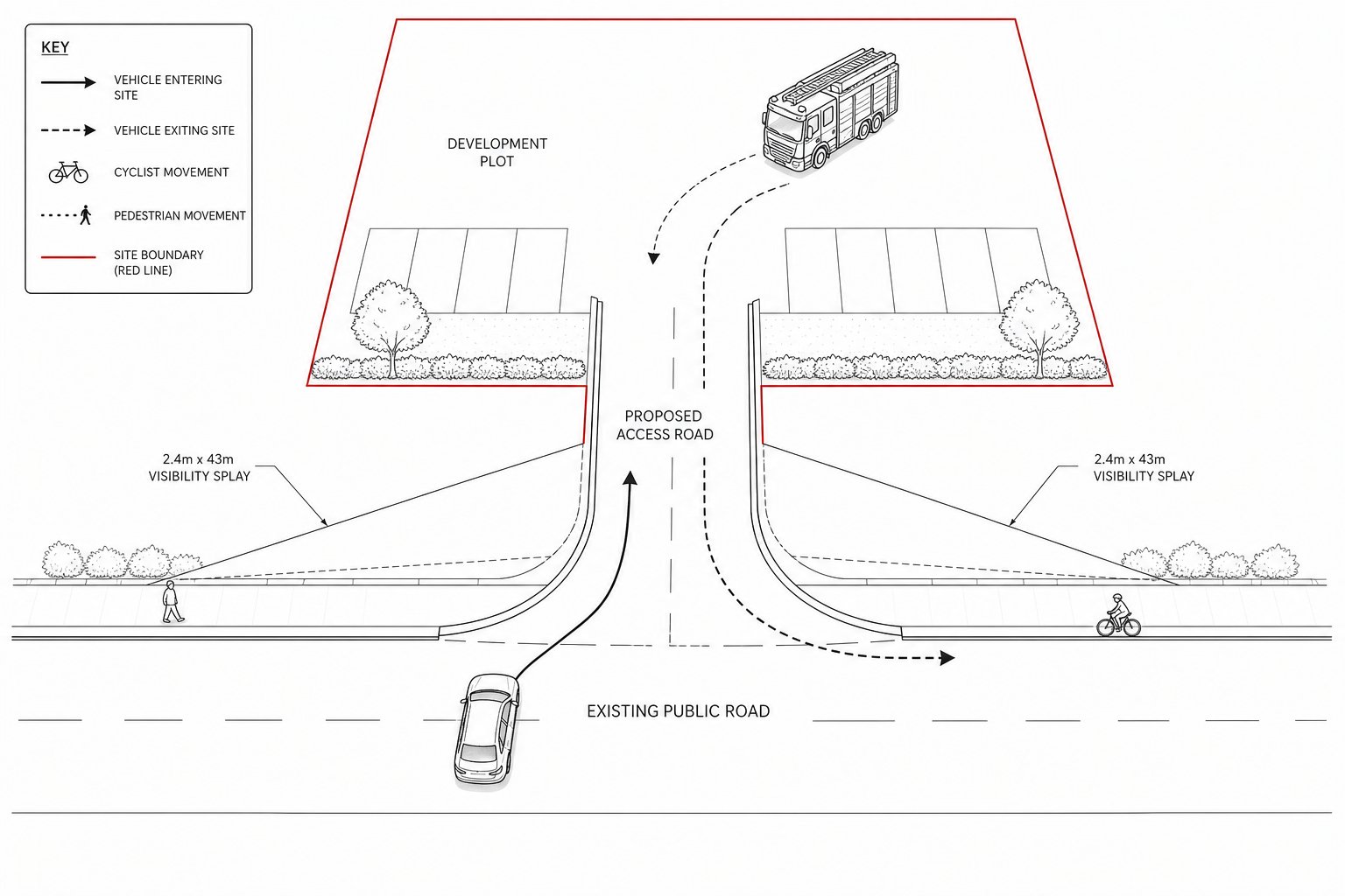
Vehicle tracking is where many concept designs meet reality. It is not enough to say a refuse vehicle can probably get in, or that a rigid HGV can “manage”. The geometry, lane widths and corner radii should be tested against the design vehicles the development will generate regularly.
Residential schemes may need refuse vehicles, fire appliances and delivery vans. Employment or retail sites may need articulated vehicles, coaches or larger service vehicles. The right answer depends on use, management and expected frequency.
Swept path analysis helps show whether vehicles can turn without mounting footways, crossing excessively into opposing lanes, or creating conflict at the site entrance. In constrained settings, some overrun or shared carriageway use may be acceptable, but it needs to be understood and justified, not left vague.
And this is often where applications are won or lost. A tidy-looking layout with no credible turning evidence invites queries. A tested layout, even if modest and tightly designed, is much easier to defend.
Choosing The Right Junction Form For The Site Context
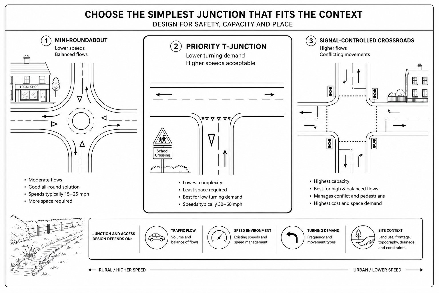
The right junction form depends on traffic flow, turning demand, speed environment, road hierarchy, land take and nearby constraints. There is no prestige in choosing the most complex option. Decision-makers generally want the simplest arrangement that safely accommodates demand and fits the context.
For many small and medium schemes, that means a priority junction. It is familiar, efficient and often easiest to integrate with frontage development. But once turning flows rise, speeds increase, or right-turning vehicles start to block through traffic, another form may be needed.
Context is crucial. An urban edge site near schools or shops may need a stronger emphasis on crossing movements and speed control. A rural site may be dominated by visibility, verge drainage and larger vehicle turning needs. Existing junction spacing also matters: even a technically workable access can be unacceptable if it sits too close to another node and creates a confusing cluster of conflicts.
In practice, we advise teams to compare realistic options early and document why one junction form is preferable. That record is useful in pre-app dialogue and can save a lot of circular debate later.
Simple Priority Junctions, Mini-Roundabouts, And Signal Control
Simple priority junctions suit many developments where side-road flows are modest and visibility is adequate. They tend to be the default starting point because they are straightforward to understand and economical to build.
Mini-roundabouts can work well where approach speeds are moderate and turning movements are more balanced. They can reduce delay and force lower speeds, though they need enough geometry to function properly. On constrained sites, a mini-roundabout drawn to fit can perform badly in operation if entries are awkward or deflection is weak.
Signal control usually enters the picture when capacity, pedestrian crossing needs, or network coordination become more significant. Signals can manage competing demands better, but they also introduce staging, queueing effects, maintenance considerations and often greater justification requirements.
Roundabouts and signals are not “upgrades” in some abstract sense. They are responses to specific problems. The strongest planning submissions show that the chosen form matches forecast demand and site context, rather than reaching for complexity because it looks more substantial.
Access Design Requirements For Different Development Types
Different land uses generate different design pressures, and local authorities usually expect access arrangements to reflect that from the outset.
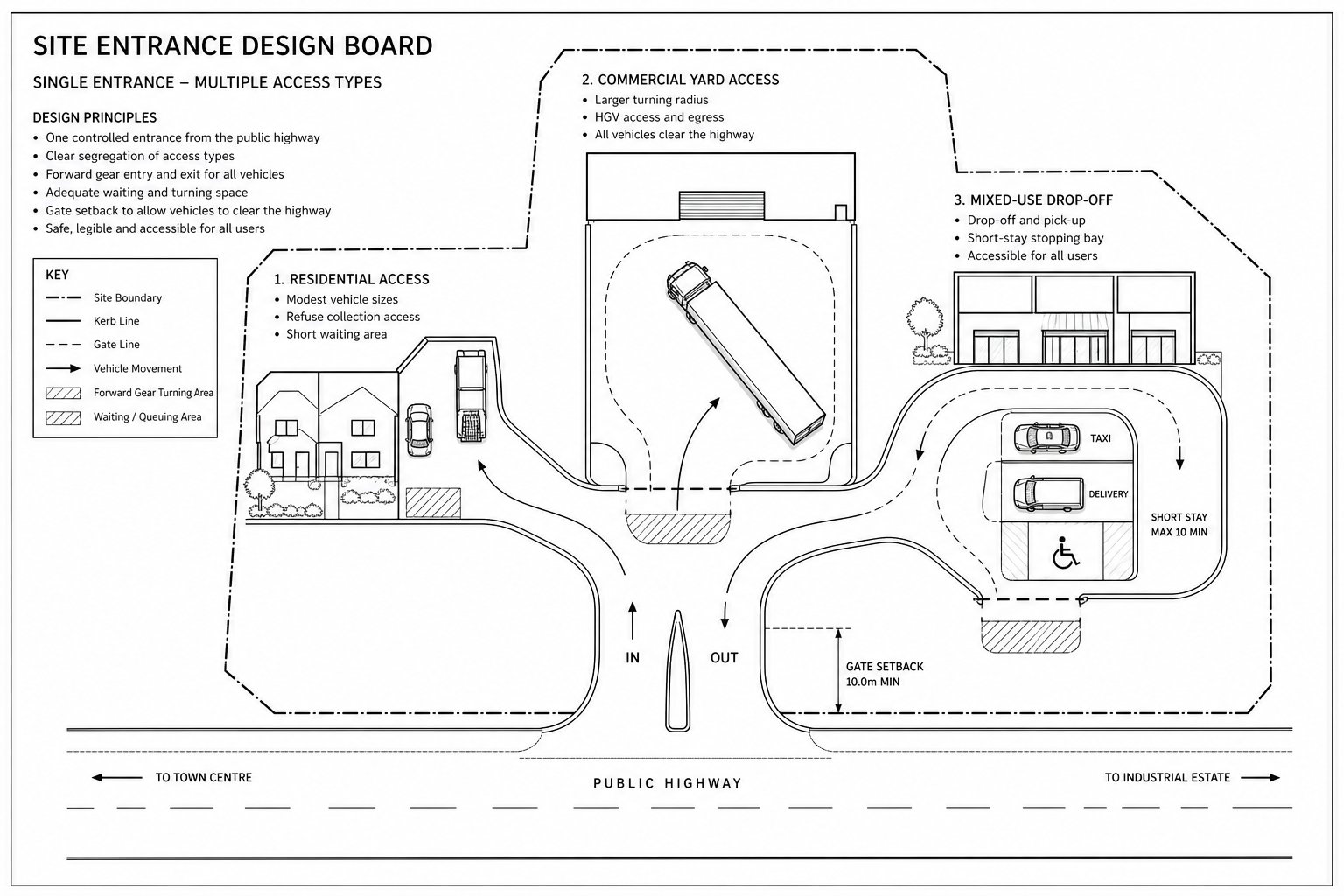
Residential development often favours simple, legible access points with geometry suitable for day-to-day domestic traffic, refuse collection and emergency access. On faster roads, turning space within the site may be needed so vehicles can leave in forward gear. Private drives serving a very small number of homes can remain simple, but once an access serves more units, the standard generally steps up.
Commercial and employment schemes usually require a more disciplined servicing strategy. Larger radii, gate setbacks, waiting space, loading arrangements and separate staff or visitor access may all be relevant. A warehouse yard that works operationally but causes HGVs to pause on the public highway is unlikely to satisfy highway officers.
Retail, education, healthcare and mixed-use schemes bring their own patterns: peaks at school start times, short-stay stopping, taxis, delivery windows, mobility-impaired users and more varied trip purposes. In those cases, access design cannot be reduced to simple car entry geometry.
This is also where early operational thinking helps. With the right evidence, teams can shape a proportionate access arrangement rather than defaulting to excessive width or conservative assumptions that damage placemaking and still fail to resolve the real issue.
Walking, Cycling, Servicing, And Inclusive Movement
A junction that works for cars but fails everyone else is no longer likely to feel acceptable in planning terms. Walking, cycling, wheeling and servicing all need to be embedded in the design, not retrofitted once the carriageway geometry is “done”.
Pedestrian and cycle route continuity through a junction is especially important. If corner radii are larger than necessary, crossing distances increase and turning speeds creep up. Keeping radii to the minimum that still accommodates swept path requirements usually produces a better outcome for vulnerable users.
Inclusive movement means thinking beyond formal compliance. Can a wheelchair user cross without awkward cambers? Is tactile paving aligned sensibly? Are crossing points placed on desire lines, not wherever space happened to be left over? Does servicing interrupt footway continuity or create reversing conflicts at the wrong times?
Servicing deserves equal attention because poorly managed delivery activity can undermine an otherwise sound layout. Refuse, parcel vans, maintenance vehicles and occasional larger deliveries all need routes and turning space that do not compromise pedestrian safety.
In 2026, highway comments increasingly reflect healthy streets and inclusive design objectives. So the question is not simply whether non-car movement has been acknowledged: it is whether the access arrangement genuinely supports it.
Drainage, Levels, Lighting, And Other Detailed Design Constraints
Detailed constraints are often what turns an apparently compliant access into a redesign exercise. Drainage is a classic example. If surface water runs towards the highway, ponds at the bellmouth, or conflicts with existing gullies and levels, the access detail may become unacceptable even if the geometry was sound in principle.
Levels matter just as much. Approaches to the give-way line usually need to be levelled appropriately so drivers can stop and observe safely. Excessive gradient close to the junction can affect visibility, braking and comfort, and it can be particularly awkward for larger vehicles or cyclists.
Lighting can also influence the acceptability of a scheme, especially where new movements are introduced onto an unlit route or where pedestrian crossing activity is expected. Then there are the constraints nobody loves but everyone eventually has to deal with: utilities, retaining features, trees, drainage easements, boundary ownership and visibility over third-party land.
A sensible approach is to resolve these issues early enough that they inform the concept layout. Too many applications treat them as technicalities for later discharge, when in fact they can alter the developable envelope and the junction form itself.
How Junction And Access Design Supports Transport Assessments And Planning Statements
Transport Assessments and Transport Statements are only as persuasive as the access assumptions sitting underneath them. If the junction form is vague, or if visibility and turning movements are unresolved, every downstream conclusion becomes weaker.
A well-developed access concept supports trip distribution assumptions, capacity modelling, road safety appraisal and mitigation proposals. It also gives confidence that the red-line layout is realistic. That matters in planning, because officers and consultees are rarely reassured by a statement that says detailed design will sort everything out later.
Where relevant, evidence may include priority junction capacity modelling, junction assessment software outputs, queue analysis, swept path diagrams, visibility drawings and Road Safety Audit input. The purpose is not to bury the reader in technical appendices. It is to demonstrate that the proposal has been tested against the issues most likely to affect acceptability.
For planning statements and Design and Access Statements, the access narrative should be consistent with the transport evidence. That sounds obvious, but mismatches are common. We often find the strongest outcomes come when transport input is coordinated early with layout design, and when concise Access Strategy Transport evidence is aligned to local thresholds and authority expectations.
Common Design Mistakes That Delay Applications
Some problems recur so often that they are almost predictable.
The first is inadequate visibility, especially where a new access is placed too close to a bend, on a crest, or behind boundary features that no one has properly accounted for. The second is weak swept path provision: radii that look neat on plan but do not actually work for refuse vehicles, service vehicles or emergency access.
Another common mistake is overloading a frontage with multiple accesses or placing a new junction too close to an existing one. Even if each individual movement seems manageable, the cumulative effect can create confusion, additional conflict points and poor streetscape quality.
Then there is omission by optimism: no clear pedestrian crossing strategy, little thought for cycling continuity, vague servicing assumptions, or no explanation of how deliveries and refuse are managed. These gaps often lead to holding objections because officers need certainty, not hope.
A subtler issue is inconsistency across documents. The site layout, TA, tracking drawings and planning statement should all describe the same scheme. When they don’t, decision-makers start questioning the reliability of the whole submission. That can delay validation, trigger further rounds of comments, and in some cases undermine the application more than the original technical issue would have done.
What Local Authorities Typically Expect At Submission Stage
By submission stage, local authorities generally expect more than a broad indication of where vehicles might enter the site. They want a defined junction form, dimensions that reflect applicable standards, and drawings that show the proposal has responded to the local context.
For many schemes, that means a general arrangement drawing, visibility splays, basic longitudinal and crossfall information, and swept path analysis for the relevant design vehicles. Where traffic impact is material, capacity modelling or a proportionate junction assessment is often expected as well.
Authorities also look for compliance with their own highway design guides alongside national standards and policy. That local layer matters. Thresholds, preferred formats, tracking expectations and adoption requirements vary, sometimes quite a lot, between authorities.
The submission should also explain why the proposed arrangement is appropriate rather than merely presenting it as a fait accompli. A clear narrative in the transport and planning documents helps officers understand the design logic quickly.
When this is done well, consultation tends to be more focused and constructive. When it is not, even experienced teams can find themselves answering avoidable questions about basics that should have been settled before the application went in.
Good junction and access design is rarely the loudest part of a planning submission, but it is often one of the most decisive. If the scheme is legible, evidence-led and tailored to the site, decision-makers have a far firmer basis for saying yes. If not, the access becomes the reason everything else starts to wobble.
Frequently Asked Questions about Junction and Access Design
What is junction and access design in the planning process?
Junction and access design is how roads, accesses and movement routes are arranged so a development connects safely and efficiently to the existing highway network, typically defined at the concept or masterplan stage and refined during planning.
Why is junction and access design critical for planning approval?
It influences safety by reducing collision risks through good geometry and visibility, controls capacity to prevent traffic delays and queues, and provides credible transport evidence essential for planning decisions and Transport Assessments.
How do visibility and speed affect junction design?
Visibility splays at driver eye height must be maintained, ideally on level or sag alignments, not crests. Design elements like narrowing and raised tables help moderate vehicle speeds and manage user behaviour for safer junction operation.
Which junction forms are most suitable for different developments?
Most schemes use simple priority T-junctions, staggered junctions or mini-roundabouts. Roundabouts or signals are reserved for higher traffic flows or speed environments and are chosen based on capacity and site context rather than prestige.
How does junction design accommodate walking, cycling and inclusive movement?
Good design ensures continuity of pedestrian and cycle routes with minimum necessary corner radii, includes active travel facilities, and considers inclusive access features such as tactile paving and suitable crossings for wheelchair users.
What common mistakes delay junction design approvals?
Frequent issues include inadequate visibility splays often caused by poor location planning, insufficient swept path analysis for design vehicles, too many poorly spaced accesses, and failure to plan for pedestrians, cyclists, or servicing requirements.