A surprising number of planning delays come down to something that looks straightforward on the drawing but unravels under scrutiny: access. A site may have land, demand and a viable layout, yet if the route in and out is poorly justified, unsafe, or disconnected from the wider network, the whole proposal starts to wobble.
That is why access strategy transport planning matters so much in 2026. It is not just about where the bellmouth sits or whether a refuse vehicle can turn. It is the disciplined case for how people, goods and services will reach a development safely, conveniently and sustainably, and how that access will work with the surrounding highway, walking, cycling and public transport networks.
For architects, planners, lawyers, surveyors, developers and local authorities, the practical challenge is rarely the label. It is knowing what a robust access strategy actually needs to include, how much evidence is enough, and where schemes most often run into objections from highway officers.
In our experience, strong access planning is usually clear rather than flashy. It joins policy, geometry, surveys and real-world movement patterns into one coherent story. Get that story right early, and a planning application stands on firmer ground. Get it wrong, and even a promising scheme can spend months in redesign, negotiation or appeal.
This guide sets out what a planning-ready access strategy looks like, what evidence supports it, and how to prepare it for effective local authority review.
What Access Strategy Means In Transport Planning
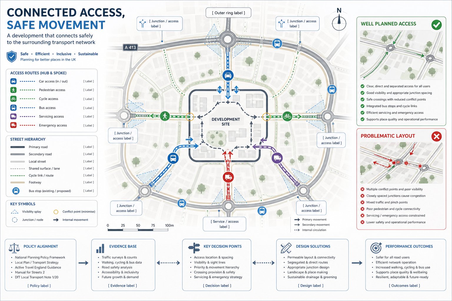
An access strategy in transport planning is the structured explanation of how a development connects to the transport network and how that connection will function for all users. In plain terms, it covers how vehicles, pedestrians, cyclists, buses, servicing vehicles and, where relevant, emergency access will enter, leave and move around a site without creating unacceptable safety or operational problems.
That sounds simple. It rarely is.
A proper access strategy is broader than a single access drawing. It combines design intent, technical evidence and policy alignment. It should show not only the physical arrangement of access points, but also why those arrangements are appropriate for the site context, local street hierarchy and expected travel patterns.
In UK planning practice, the strategy often sits within a Transport Statement or Transport Assessment and helps address the familiar test of whether the development offers safe and suitable access for all users. That includes people arriving on foot, by cycle or public transport, not just by car.
This is also where access management comes in. Too many access points, poor spacing from junctions, weak visibility or awkward servicing arrangements can all undermine a proposal. By contrast, a well-considered strategy reduces conflict, supports efficient movement and fits the surrounding network rather than fighting it.
For applicants needing concise technical support, the thinking overlaps strongly with the kind of planning-led advice described in Property Development Transport: it starts early, responds to local authority expectations, and ties transport evidence back to the planning narrative.
Why Access Strategy Matters For Planning Applications
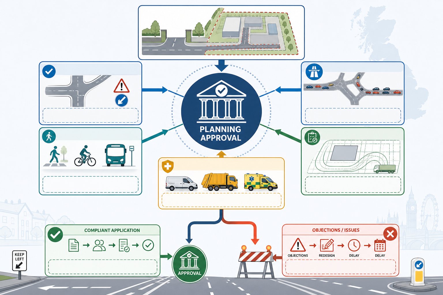
Access can make or break an application because it sits right at the intersection of planning policy, highway safety and deliverability. Local planning authorities and highway officers are not only asking whether a development can be built. They are asking whether it can operate acceptably once occupied.
A robust access strategy helps answer several critical questions at once:
- Is the proposed access safe for all users?
- Will it create unacceptable risk or conflict on the local highway network?
- Does it support sustainable travel rather than forcing car dependency?
- Can servicing, deliveries and emergency movements be accommodated?
- Is the proposal genuinely workable, or just graphically convenient?
If those questions are left vague, objections follow quickly. We often see concern focused on collision risk at new junctions, substandard pedestrian routes, visibility constraints, queueing impacts, or layouts that look acceptable for cars but ignore cycling and refuse collection.
That is why access strategy transport planning is not a side note. It underpins decisions on suitability, residual cumulative impact and the practical use of the site. For larger or more sensitive schemes, it can also influence viability, reserved matters discussions, Section 278 works and the scope of planning conditions.
In a busy planning programme, early technical input tends to save time later. That is one reason many applicants engage Developer Transport Consultants: What issues before a layout hardens into something difficult to defend. A modest design adjustment at concept stage is usually far cheaper than reworking access after a formal objection lands.
The Core Principles Of A Strong Access Strategy
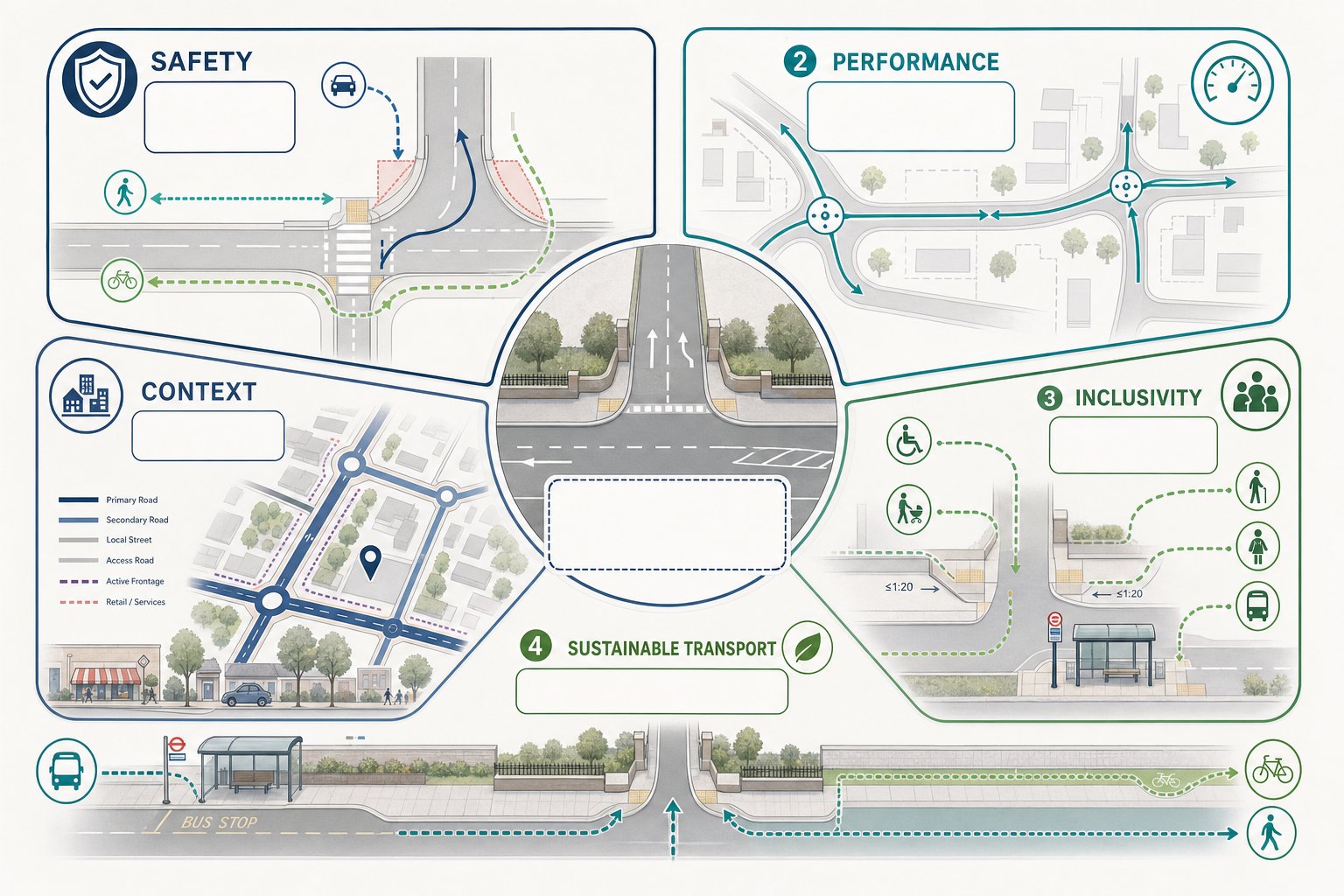
A strong access strategy is not built around a single metric. It balances safety, functionality, inclusivity and context. Good schemes do not simply push traffic through a gap in the boundary: they shape movement in a way that reflects how streets actually work and how people actually travel.
At a minimum, we would expect the strategy to demonstrate five things: that the access arrangement is safe, that it performs acceptably, that it works for different user groups, that it supports sustainable transport, and that it responds to the character and hierarchy of the surrounding network.
Safe And Suitable Access For All Users
This is the baseline test, and rightly so. Access should minimise conflict between vehicles, pedestrians and cyclists, especially at points where crossing, turning and servicing movements overlap. That means looking carefully at geometry, visibility, vehicle speeds, crossing desire lines, gradients, waiting areas and whether vulnerable users are being squeezed into left-over space.
A scheme may technically accommodate a car access while still failing the wider planning test if pedestrian routes are indirect, crossing points are weak, or cycle movements are forced into conflict with turning traffic. Inclusivity matters here as much as geometry. Parents with prams, older residents, wheelchair users, schoolchildren and bus passengers all experience the site differently.
The best access strategies do not treat these needs as add-ons. They bake them into the front end of the design.
Integration With The Surrounding Highway And Movement Network
Even a neatly designed access can fail if it ignores its setting. Access points need to align with the road hierarchy, nearby junctions, crossing locations, bus stops and established walking and cycling routes. A development should feel connected to the wider movement network, not stranded on it.
This is especially important where several constraints pull in different directions: a classified road frontage, adjacent driveways, existing trees, frontage activity, or public transport stops close to the site boundary. Integration means understanding how the proposed access affects operations beyond the red line.
That broader network view often separates workable schemes from fragile ones. In urban areas, applicants commonly need to show how access interacts with signal junctions, kerbside activity, cycle corridors and loading pressure. In suburban or edge-of-settlement locations, the focus may shift to visibility, speed environment, bus stop accessibility and whether pedestrians can reach local facilities safely.
And yes, local context matters a lot. The practical issues considered by a Traffic Engineer In Leeds: setting may differ from those in a town-centre authority, even when policy language looks familiar on paper.
How Access Strategy Supports Different Types Of Development
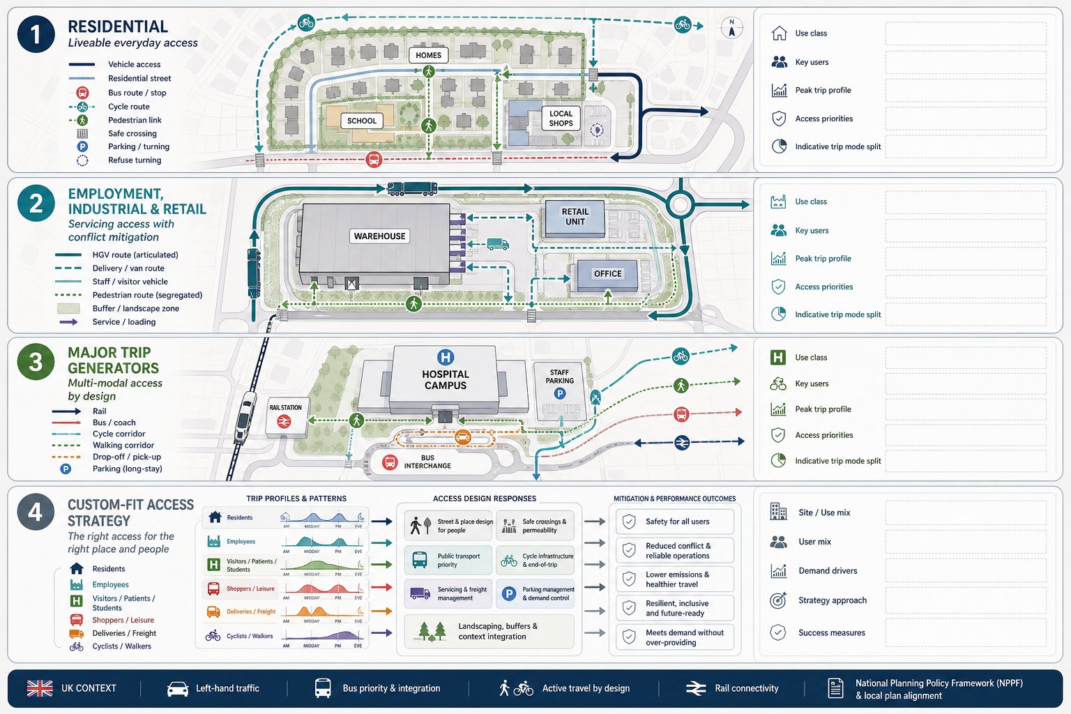
Not every development asks the same question of its access strategy. A small residential infill site, a logistics yard and a mixed-use town-centre scheme can all require very different responses, even where the planning principles are similar.
For residential development, the emphasis usually falls on everyday convenience and liveability. Can residents walk to schools, shops and bus stops without negotiating hostile crossings or dead-end footways? Is cycle access direct enough to be realistic? Will domestic parking, refuse collection and visitor movements work without creating low-level but persistent conflict? On many schemes, the strongest access move is not a wider junction: it is a better pedestrian connection.
Employment, industrial and retail sites bring another layer: servicing, shift patterns and freight. Here the access strategy has to address vehicle size, loading activity, routeing and the interface between staff, visitors and commercial traffic. If HGVs and pedestrians are expected to share constrained space, local authorities will want very clear justification and mitigation.
Larger trip generators, including education, healthcare and transport hubs, often need a mode-share perspective as well. Surface access planning becomes central: how the proposal will reduce single-occupancy car trips, connect to public transport and support active travel at scale.
This is why access strategy transport planning should always be development-specific. Templates rarely convince. A planning-ready strategy speaks directly to how the use class, trip profile and user mix shape access demand, design choices and mitigation requirements.
Key Evidence And Surveys Needed To Inform Access Design
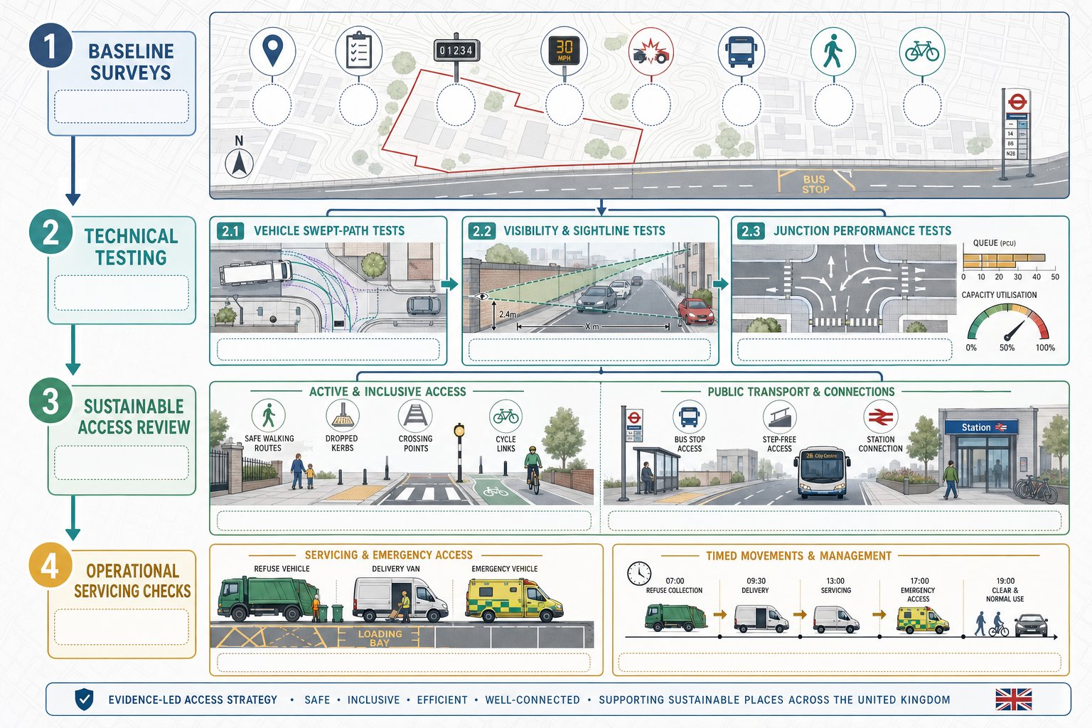
An access strategy is only as persuasive as the evidence behind it. Officers do not want assertion: they want a clear chain from baseline conditions to design response. That usually means combining site observation, measured data and technical testing.
The exact evidence package depends on scale and context, but most robust submissions draw on traffic counts, turning counts, speed data, collision records, topographical information, site constraints, public transport provision, and walking and cycling audits. For larger schemes, parking accumulation, servicing demand and mode split analysis may also be needed.
The trap, oddly enough, is not always too little data. Sometimes it is the wrong data, collected at the wrong time, then stretched to answer questions it cannot really answer. A school-adjacent site surveyed outside term time, for example, may produce a very tidy dataset and a very shaky planning case.
Vehicle Tracking, Visibility, And Junction Performance
These are often the first technical tests people think about, because they are easy to visualise and easy for consultees to challenge. Swept-path analysis demonstrates whether the design vehicle can enter, turn, service and exit without overrunning footways, clipping street furniture or relying on unrealistic manoeuvres. It should reflect actual vehicle needs, not just the most convenient drawing standard.
Visibility is equally fundamental. Splays, stopping sight distance and forward visibility must respond to the speed environment and local conditions. If boundary walls, vegetation, parked vehicles or vertical alignment constrain visibility, the strategy needs to deal with that openly.
Junction performance then tests whether the access arrangement operates acceptably in network terms. Depending on context, that may involve priority-junction modelling, signal modelling, queue assessment or practical reserve capacity review. The aim is not to pretend every junction is free-flowing. It is to show that delay, queueing and interaction with nearby junctions remain acceptable and defensible.
Walking, Cycling, Public Transport, And Servicing Requirements
This is where many access strategies improve markedly, or come unstuck. A proposal can pass a vehicle-tracking check and still fall short if active travel and public transport links are weak.
Pedestrian routes should be direct, legible and safe. That means considering width, surfacing, gradient, lighting, crossing provision, dropped kerbs and how users move beyond the site boundary. Cycling provision needs similar honesty: painted intent is not the same as a connected route.
Public transport assessment should cover proximity, frequency, route choice and the quality of access to stops or stations. If a bus stop is technically close but requires a difficult crossing of a busy arm, that matters. So does whether sheltered waiting, interchange and timetable coverage make the option genuinely usable.
Servicing must be planned with equal care. Delivery bays, refuse collection, management vehicles and emergency access should work without blocking primary pedestrian routes or creating repeated conflict at peak times. On urban schemes, timed deliveries and operational controls can be just as important as geometry.
In practice, this is often where local knowledge helps, particularly in places with tightly managed networks and sensitive frontage conditions, such as those handled by a Traffic Engineer In Manchester: project team.
Common Planning Issues That Delay Or Weaken Access Proposals
Most weak access proposals do not fail because of one dramatic flaw. They fail because a cluster of smaller issues leaves doubt hanging over the scheme.
A common problem is over-reliance on a vehicle-led layout. The drawing may show cars getting in and out efficiently, but pedestrians are left with awkward routes, no clear priority, or poor crossing opportunities. Highway officers notice that immediately.
Another regular issue is access proliferation: too many access points, poor spacing from adjacent junctions, or new openings onto roads where turning movements already create pressure. Every extra conflict point invites scrutiny. If the strategy cannot justify why access is arranged that way, objections become hard to rebut.
Then there is evidence quality. Underestimated trip generation, unrepresentative surveys, weak speed data, unclear tracking diagrams and optimistic modelling assumptions all undermine confidence. Even when the physical design is broadly workable, poor technical presentation can make the proposal look less credible than it is.
We also see schemes weakened by standards non-compliance without proper explanation. Departures are not always fatal, but unexplained departures usually are. If a visibility splay is constrained, if a footway width is below preference, or if servicing requires management controls, the strategy should address that directly and proportionately.
The practical lesson is simple: local authorities are not just reviewing drawings. They are reviewing judgement. A convincing access strategy anticipates the obvious questions before they are raised.
How Access Strategy Fits Within Transport Assessments And Planning Documents
An access strategy is rarely a standalone planning document. More often, it forms a core part of the wider transport submission and helps tie together policy, evidence and design.
Within a Transport Statement or Transport Assessment, the access strategy explains how baseline conditions, trip generation, servicing needs, sustainable travel opportunities and highway impacts have informed the proposed arrangement. It is the narrative that turns technical appendices into a coherent planning case.
That role matters because transport documents can become fragmented if each part answers a different question in isolation. A junction model may demonstrate capacity, a tracking plan may prove manoeuvrability, and a site plan may show footways, but without a clear access strategy the authority is left to assemble the story itself. That is not ideal for anyone.
A good strategy also links naturally with travel planning, delivery and servicing plans, construction logistics, design and access statements, and sometimes flood or public realm documents where access levels, gradients or frontage treatment overlap. On major schemes, it may support planning conditions, reserved matters parameters and off-site highway agreements.
For applicants, the key is consistency. The access assumptions in the transport chapter should match the architectural layout, servicing approach and sustainability narrative. Where teams are working quickly, that sounds obvious, yet mismatches are surprisingly common.
That joined-up approach sits at the heart of effective access strategy transport planning: one evidence-based story, told clearly across all planning documents.
Preparing An Effective Access Strategy For Local Authority Review
If we want an access strategy to stand up under review, we need to write and draw it for the officer reading it, not just for the project team that already knows the scheme. That means clarity, proportionality and evidence that can be followed without guesswork.
Start with policy and context. Set out the relevant national and local standards, the site constraints, the surrounding movement network and the development’s expected access demands. Then show how those factors have shaped the proposed arrangement. Officers should be able to understand not only what is proposed, but why.
Early engagement helps enormously. Pre-application discussions with highway and transport officers can identify whether the authority is most concerned about visibility, speed environment, sustainable access, servicing, nearby junction interaction or something more local and site-specific. It is much easier to refine scope early than to retrofit justification later.
Presentation matters too. Plans should be legible. Tracking diagrams should be realistic. Modelling assumptions should be transparent. Supporting notes should explain departures, mitigation and operational controls without burying the reader in unnecessary jargon.
We also find that concise reporting tends to carry more weight than bloated reporting. Authorities want sufficient detail, not theatre. That is very much the ethos behind Property Development Transport Advice: clear, locally tailored reporting: answer the real planning questions, and answer them well.
Finally, sense-check the strategy against the objections most likely to arise. If someone asks whether the access is safe, suitable, inclusive, connected and evidence-led, the document should allow a confident yes.
Conclusion
A robust access strategy is not decorative paperwork. It is central to showing that a development can be reached, used and serviced safely and sensibly within its real transport context.
When access strategy transport planning is done properly, it does three things at once: it demonstrates safe and suitable access for all users, it shows how the proposal integrates with the wider highway and movement network, and it gives planning and highway authorities the evidence they need to support a decision.
For development teams, that means starting early, grounding the design in surveys and site reality, and treating walking, cycling, public transport and servicing as core parts of the access question rather than afterthoughts. The strongest submissions are usually the clearest ones.
In 2026, with policy pressure still focused on safety, sustainability and defensible evidence, access strategy will remain one of the most practical levers for strengthening planning applications. Get it right, and the rest of the transport case becomes much easier to trust.
Frequently Asked Questions about Access Strategy Transport Planning
What is an access strategy in transport planning?
An access strategy in transport planning details how a development connects safely and efficiently to transport networks for all users, including vehicles, pedestrians, cyclists, and public transport, ensuring safe, suitable, and sustainable access.
Why is access strategy important for planning applications?
Access strategy matters because it demonstrates that a development can provide safe and suitable access for all users, supports highway safety, sustainable travel, and operational viability, which are critical for securing planning approval.
What core principles should a strong access strategy follow?
A robust access strategy balances safety, functionality, inclusivity, sustainable transport support, and sensitivity to the local context, ensuring efficient movement and conflict reduction among all transport modes.
How does an access strategy support different types of developments?
Access strategies are tailored to development types: residential focuses on walkability and local services; employment and retail sites address servicing and freight; major trip generators prioritize sustainable transport and mode-share shifts.
What key evidence is needed to support an access strategy?
Effective access strategies rely on traffic and turning counts, speed and collision data, walking and cycling audits, public transport assessments, vehicle tracking, visibility analysis, and junction performance modelling to justify design choices.
How can early engagement with local authorities improve access strategy outcomes?
Engaging early with highway and transport officers clarifies local concerns, allowing tailored design and evidence collection that meet policy standards, reducing objections and strengthening the planning application.