Transport decisions rarely stop at a site boundary. A housing allocation in one district can load pressure onto a junction two authorities away: a new employment park may depend less on its access road than on a regional bus corridor, rail service, or freight route that sits outside the red line entirely. That is why regional transport planning UK has become such an important part of the planning conversation in 2026.
For developers, architects, planning consultants, local authorities and legal teams, the issue is practical rather than abstract. Regional transport planning shapes what evidence is expected, how cumulative impact is judged, which growth locations are prioritised, and whether a scheme looks aligned with wider policy or in conflict with it. Get that context right, and an application tends to read as credible, deliverable and policy-aware. Miss it, and even a technically competent submission can feel oddly incomplete.
In this guide, we set out what regional transport planning means in the UK system, who influences it, how it feeds into planning applications, and the key issues decision-makers are testing. We will keep the focus on real development implications: transport assessments, trip generation, accessibility, infrastructure capacity, freight, resilience and decarbonisation. And because time matters in live projects, we will approach the topic in the same way we approach transport evidence generally, clearly, directly and with an eye on what actually helps smarter planning decisions.
What Regional Transport Planning Means In The UK Planning System
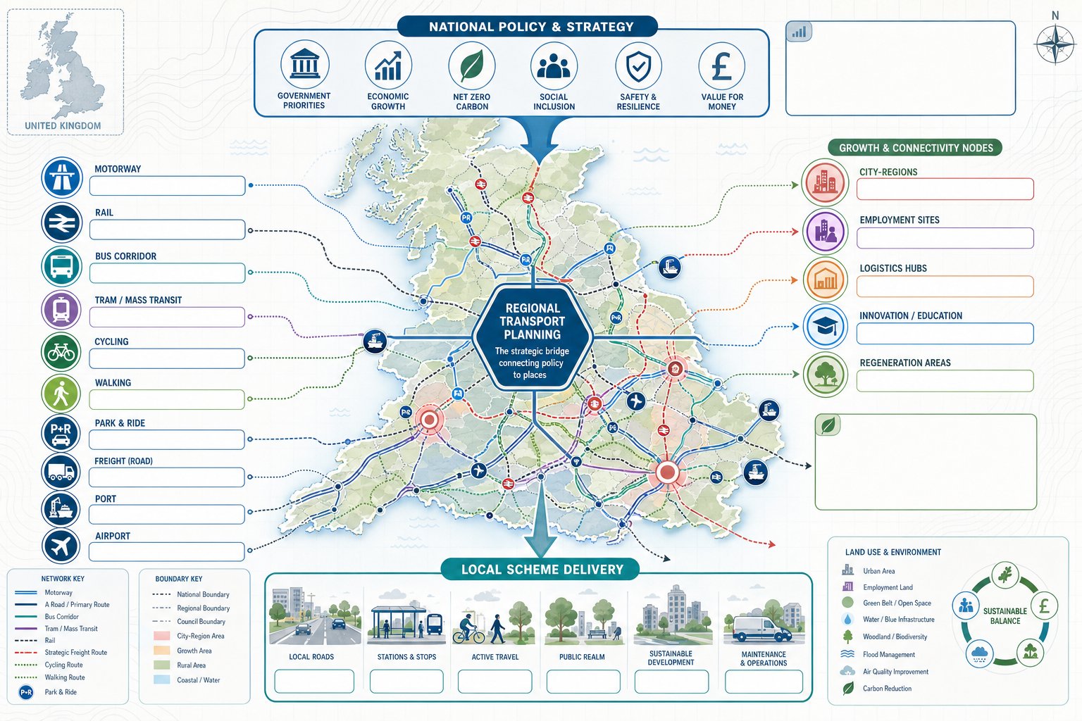
Regional transport planning sits between national transport policy and the detailed delivery of local highways or public transport schemes. In simple terms, it is the strategic planning of movement across a city-region, growth corridor, county grouping, or wider economic area so that transport investment supports land use, economic development and environmental goals together rather than in isolation.
In the UK context, that usually means looking across administrative boundaries. People do not live, work, shop and travel neatly within one council area, so the planning system cannot sensibly assess transport demand that way either. A strategic employment site may draw labour from several districts. A logistics hub may affect motorway junctions, rail freight capacity and local roads at the same time. Regional planning tries to make sense of those interdependencies.
It is also multi-modal by design. Roads still matter, of course, but so do rail links, bus priority corridors, mass transit proposals, walking and cycling networks, park-and-ride, and freight routes serving ports, airports and distribution centres. Good regional plans do not treat these as separate silos. They test how the whole network performs under growth.
For planning professionals, the key point is this: regional transport planning is not just a policy backdrop. It provides the strategic logic for where development should be concentrated, what infrastructure is likely to be needed, and how the cumulative consequences of growth should be understood. That makes it highly relevant when we are preparing planning evidence for major or sensitive schemes.
Why It Matters For Development, Growth, And Connectivity
The reason regional transport planning matters is straightforward: development succeeds more reliably when transport networks work at the scale people actually use them. A local junction improvement might solve an immediate access issue, but it will not by itself address labour market connectivity, unreliable bus journeys, poor rail interchange, or freight delays on strategic corridors. Those wider issues often determine whether growth is merely allocated on paper or genuinely deliverable.
For development-led projects, regional strategy helps answer difficult questions early. Is a site in a recognised growth corridor? Is it supported by planned investment? Will cumulative traffic from nearby allocations exceed corridor capacity? Are there realistic alternatives to car dependency? Those are not fringe matters. They go to viability, placemaking and policy compliance.
There is also an economic dimension. Regional transport networks underpin access to jobs, skills, services and supply chains. That is why government and strategic transport bodies routinely link transport investment to productivity and regeneration. Better connectivity can widen labour catchments, support town centre recovery, unlock housing land and improve resilience for existing businesses.
And then there is decarbonisation. The planning system increasingly expects development to support lower-emission travel patterns, not simply mitigate traffic impact. Regional approaches are essential here because mode shift depends on connected networks, not isolated site measures. A single Travel Plan can help, but only if it plugs into wider bus, rail and active travel systems. In practice, stronger Net Zero Transport Planning tends to emerge when site strategy and regional strategy are pulling in the same direction.
The Main Policy And Governance Framework Shaping Regional Transport Plans
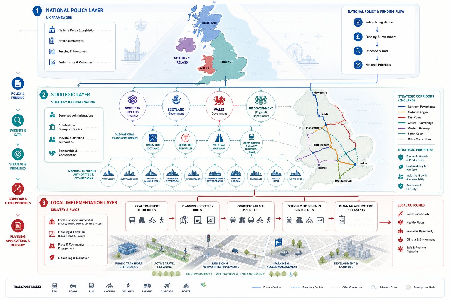
Regional transport planning in the UK is shaped by a layered governance structure, and that structure is not perfectly tidy. Responsibilities are shared across national government, devolved administrations, sub-national bodies, combined authorities and local transport authorities. For applicants and advisers, understanding who does what is more than an academic exercise: it tells us which policies carry weight, where funding decisions originate, and whose evidence base may influence an application.
National Policy, Devolution, And Strategic Transport Bodies
At the national level, the Department for Transport sets broad policy direction in England and influences funding programmes for rail, road, buses and active travel. National planning policy also matters because it frames how transport and sustainable development should be assessed through the planning process. In Scotland, Wales and Northern Ireland, devolved governments prepare their own transport strategies and investment priorities, so the regional planning context differs meaningfully across the UK.
In England, sub-national transport bodies such as Transport for the North and Midlands Connect have become important strategic actors. Their transport plans are generally non-statutory, but that should not be mistaken for irrelevance. They shape corridor priorities, evidence bases, investment cases and the language of regional growth. In live planning work, those strategies often influence how a proposal is viewed against wider economic and connectivity objectives.
Where a scheme sits within a wider strategic corridor, we usually need to show that our assumptions are consistent with prevailing policy, programme expectations and strategic modelling evidence. That is one reason a careful Transport Policy Review can strengthen an application before objections harden.
Local Transport Authorities, Combined Authorities, And Planning Roles
Local transport authorities remain central because they prepare Local Transport Plans, manage many road networks, and often comment directly on planning applications. Their priorities on bus corridors, junction improvements, parking restraint, active travel links or demand management can materially affect what supporting evidence is expected from applicants.
Mayoral combined authorities add another strategic layer in several city-regions. They frequently combine transport powers with economic development and spatial planning roles, which means decisions about growth and movement can be more joined up than in two-tier areas. In the strongest examples, transport strategy is being used not just to respond to development, but to guide where development should happen in the first place.
This is where the relationship between strategic planning and site-specific advice becomes critical. For major schemes, we often need to align the local access strategy, off-site mitigation and sustainable travel package with both local authority policy and wider regional objectives. That can include corridor protection, future mass transit, or assumptions built into strategic land allocations and Masterplan Transport Inputs: A. When that alignment is visible, applications tend to feel much more robust.
How Regional Transport Planning Influences Planning Applications
Planning applications are rarely determined solely by strategic transport policy, but regional context often shapes the questions that local authorities, highway authorities and statutory consultees ask. It influences the scope of evidence, the scale of cumulative assessment, and the extent to which a proposal is seen as helping or hindering wider growth ambitions.
A common mistake is to treat transport evidence as if it begins and ends with the site access. In reality, decision-makers are usually asking a broader set of questions. Does the scheme sit in a planned growth area? Does it rely on infrastructure that is unfunded or uncertain? Does it worsen pressure on already stressed corridors? Or does it support an established strategy for intensification around existing transport links? Regional transport planning provides the backdrop for all of that.
For applicants, this means we should frame technical work in strategic terms as well as local ones. If a site benefits from regional rail connectivity, planned bus enhancement, or active travel investment, the evidence should say so. If cumulative impact is a risk, we need to address that openly rather than hope it stays buried in someone else’s model. That sort of joined-up approach is usually what separates a persuasive application from a merely compliant one.
Transport Assessments, Travel Plans, And Supporting Evidence
Regional strategy affects the scope and emphasis of Transport Assessments, Travel Plans and supporting statements. For major development, authorities increasingly expect assessments to explain not just direct network effects, but also how the proposal aligns with broader mobility and growth objectives. In practical terms, that can influence study areas, future year scenarios, mode share assumptions and mitigation packages.
Travel Plans are a good example. A generic document promising cycle parking and welcome packs is no longer enough for many schemes. Authorities want to understand whether a development can genuinely support lower-car travel within its regional context. Is there a credible bus corridor? Are there safe links to a strategic cycle route? Is the site part of a wider place-making strategy rather than a stand-alone access exercise? A more vision led transport approach tends to perform better because it ties site design to wider network outcomes.
For applicants under time pressure, the value of experienced Transport Planning Consultants: is often that they can scale the evidence properly from the start, avoiding the all-too-familiar cycle of revised scopes, late authority comments and unnecessary delay.
Assessing Trip Generation, Network Impact, And Accessibility
Trip generation still matters, but in 2026 it is only one part of the picture. Authorities want a realistic view of how people and goods will move to and from a site, whether the surrounding network can cope, and what alternatives exist to single-occupancy car travel. Regional transport planning influences that work because it identifies strategic corridors, committed schemes, expected background growth and wider accessibility patterns.
When we assess network impact, we need to think beyond the nearest roundabout. A distribution scheme may affect freight routing across several authorities. A residential allocation might have modest peak-hour effects locally yet contribute materially to cumulative pressure on a regional commuter corridor. That is why modelling assumptions, committed development, and future infrastructure need careful alignment with the relevant strategic evidence base.
Accessibility testing is equally important. If a site has strong public transport and active travel links to jobs, schools and centres, that can support lower trip rates and a more positive planning balance. If it does not, a weak accessibility position can expose the limits of even a technically sound junction assessment. For that reason, transport evidence increasingly overlaps with public consultation transport, because local knowledge often reveals whether the network works in practice, not just on paper.
Key Issues Considered In Regional Transport Planning
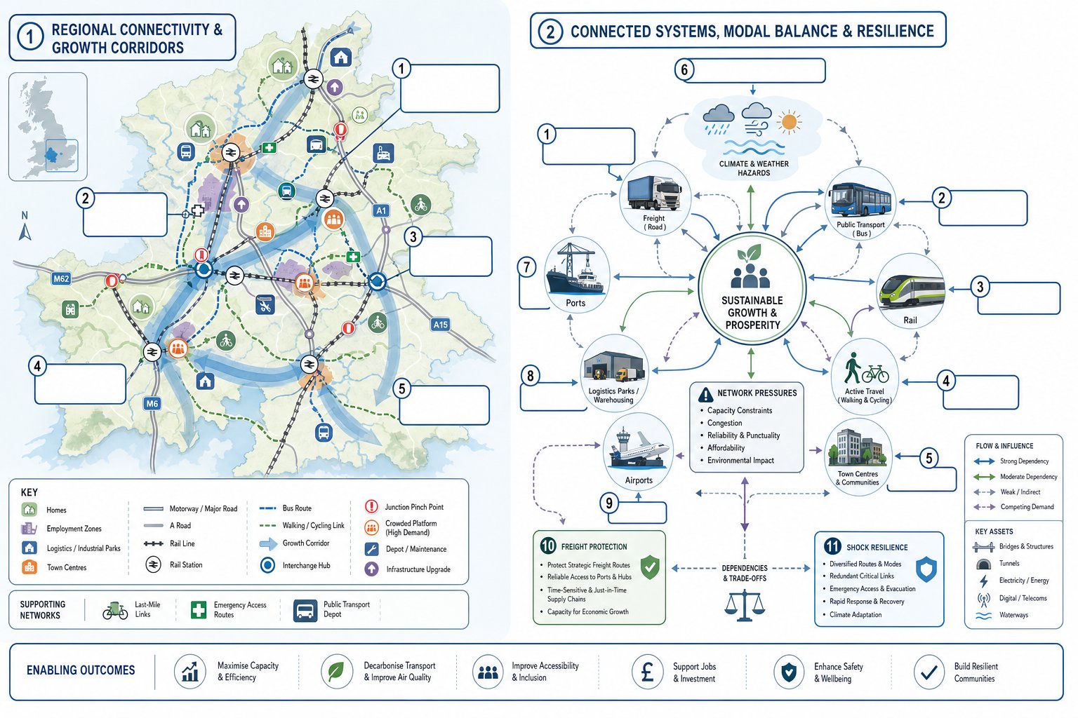
Regional transport planning has to reconcile competing demands: more homes, more jobs, cleaner travel, reliable freight movement, and infrastructure that can withstand climate and economic shocks. That balancing act explains why transport strategy can feel messy in practice. But the issues considered are fairly consistent across UK regions, and they are directly relevant to development planning.
Housing Growth, Employment Land, And Infrastructure Capacity
The first major issue is whether transport networks can support planned growth. Housing allocations, urban extensions, employment sites and logistics parks all generate demand, but not in the same way or at the same time. Regional transport planning tests where growth is expected, which corridors are already constrained, and what infrastructure upgrades may be needed to make development sustainable and deliverable.
This matters enormously for local plans and planning applications. A site can look attractive in land-use terms yet raise transport problems once cumulative growth is considered. Sometimes the issue is hard capacity, such as junction saturation or rail crowding. Sometimes it is softer but still important: poor bus viability, weak first-mile/last-mile connections, or a lack of realistic travel choices for shift workers.
Infrastructure capacity is not only about road space. It includes station access, interchange quality, depot provision, bus priority, walking and cycling permeability, and the timing of improvements relative to occupation. For larger schemes, transport input often needs to begin at masterplanning stage rather than after layout decisions are fixed. That is where highway infrastructure design and strategic access planning become part of the same conversation instead of separate workstreams.
Public Transport, Active Travel, Freight, And Network Resilience
A second core issue is modal balance. Regions are under pressure to improve public transport, support active travel and reduce transport emissions, while still allowing businesses to move goods efficiently. Those objectives can pull in different directions if they are handled badly. Freight does not disappear because a policy prefers mode shift, and bus patronage will not rise because a map contains a blue line labelled corridor improvement.
Good regional transport planning acknowledges those realities. It identifies where rail and bus investment can genuinely support denser growth, where strategic cycling links can connect neighbourhoods to centres and stations, and where freight routes need protection from inappropriate development or network fragility. Ports, airports, intermodal terminals and large distribution parks have regional effects by definition, so they need assessment at that scale.
Resilience has become much more prominent too. Extreme weather, utility works, incidents on strategic roads, rail disruption and bridge constraints can all expose how little redundancy some networks have. From a planning perspective, resilience is not a distant policy topic: it affects emergency access, construction routing, operational reliability and long-term viability. For more complex schemes, this can overlap with environmental impact assessment where transport, climate and environmental effects need to be considered together.
Common Challenges, Best Practice, And Conclusion
Regional transport planning is important, but it is not frictionless. The most persistent challenge is fragmentation. Administrative boundaries, different political priorities, uneven data quality and mismatched plan timetables can make joined-up decision-making harder than everyone would like to admit. In England, the non-statutory status of some sub-national transport bodies adds another wrinkle: their strategies may be influential without always being determinative.
Funding uncertainty is another recurring issue. Plans can identify the right corridor intervention and still struggle because delivery timing, business cases or national spending priorities shift. That uncertainty matters for applicants, particularly where the acceptability of a site depends on infrastructure that is planned but not yet committed. It is one of the reasons we favour clear, evidence-led statements about what a development can support now, what mitigation is required, and what assumptions depend on wider programme delivery.
The better examples of practice tend to share a few traits. They integrate land use and transport strategy early. They use proportionate but robust evidence. They test realistic travel behaviour rather than idealised mode share. And they engage with local and regional stakeholders before positions become adversarial. For applicants, that usually translates into earlier scoping, better baseline work, and transport reporting tailored to authority expectations and planning thresholds.
In short, regional transport planning UK is not just a strategic policy theme sitting above everyday development management. It is a live framework that affects site promotion, masterplanning, transport assessments, mitigation strategy and eventually planning outcomes. When we understand that framework properly, we make better development decisions, smarter, faster, and with far fewer surprises once the application is in.
Regional Transport Planning UK: Frequently Asked Questions
What is regional transport planning in the UK and why is it important?
Regional transport planning UK strategically coordinates movement across city-regions and economic areas to support land use, economic development, and decarbonisation. It’s vital because it ensures transport networks work efficiently at a regional scale, enabling sustainable growth and better connectivity to jobs and services.
How does regional transport planning affect planning applications for new developments?
Regional transport planning UK guides Transport Assessments, Travel Plans, and evidence by aligning site impacts with regional corridors and growth areas. Applications demonstrating consistency with strategic transport objectives, such as support for planned bus or rail investment, tend to be more credible and policy-compliant.
Which authorities and policies shape regional transport planning in the UK?
Regional transport planning UK is influenced by national government policies from the Department for Transport, devolved administrations’ strategies, and sub-national transport bodies like Transport for the North. Local transport authorities and Mayoral Combined Authorities prepare Local Transport Plans linking regional goals with local delivery.
What key transport issues are considered in regional transport planning UK?
The main issues include housing and employment growth impact on network capacity, infrastructure resilience, public transport and active travel provision, and efficient freight movement. These ensure that transport networks can support planned developments while promoting sustainable, low-emission travel options.
Why is integrating regional transport planning important for achieving Net Zero targets?
Regional transport planning UK enables cohesive approaches to mode shift by coordinating connected networks for buses, rail, cycling, and walking. This coordination supports developments that reduce car dependency and emissions, making stronger Net Zero climate outcomes more achievable across city-regions and corridors.
What challenges does regional transport planning face in the UK?
Challenges include fragmented responsibilities across authorities, the non-statutory status of some strategic transport bodies, funding uncertainties, and mismatched plan timings. Overcoming these requires integrated strategic planning and early stakeholder engagement to produce evidence-led, aligned transport strategies.