A planning layout can look perfectly tidy on paper and still fail the moment a refuse lorry tries to turn in. That gap between a neat drawing and a workable site is exactly where swept path analysis traffic becomes indispensable.
In practical terms, swept path analysis is the manoeuvring check that tells us whether a vehicle can actually enter, turn, load, circulate and leave a site without mounting kerbs, clipping walls, overrunning footways or forcing awkward reversing movements. For architects, planners, developers, solicitors and local authorities, it often becomes one of those documents that quietly decides whether a scheme moves forward smoothly or gets stalled by highways comments.
We see this regularly in planning work. A development might satisfy land use, scale and parking numbers, yet still attract objections because the access geometry is too tight for servicing, emergency access or refuse collection. And once highways officers raise concerns, a small design issue can quickly become a delay in validation, an amendment request, or a costly redesign.
That is why this guide focuses on the real-world use of swept path analysis in traffic and highway planning for 2026 applications: what it is, when it is needed, which vehicles are usually tested, how tracking is carried out, what affects accuracy, and what a robust report should contain.
What Swept Path Analysis Is And Why It Matters In Traffic Planning
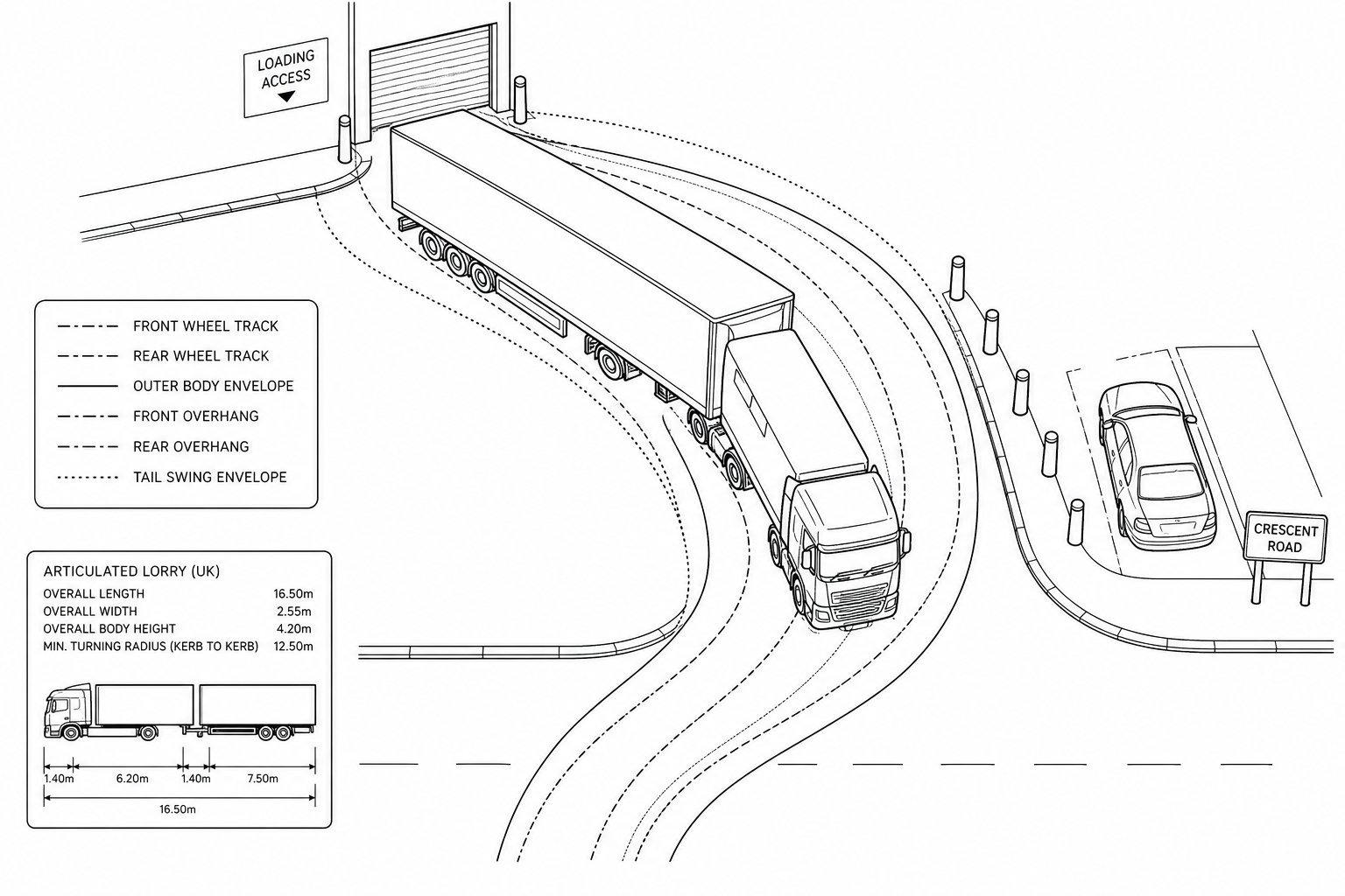
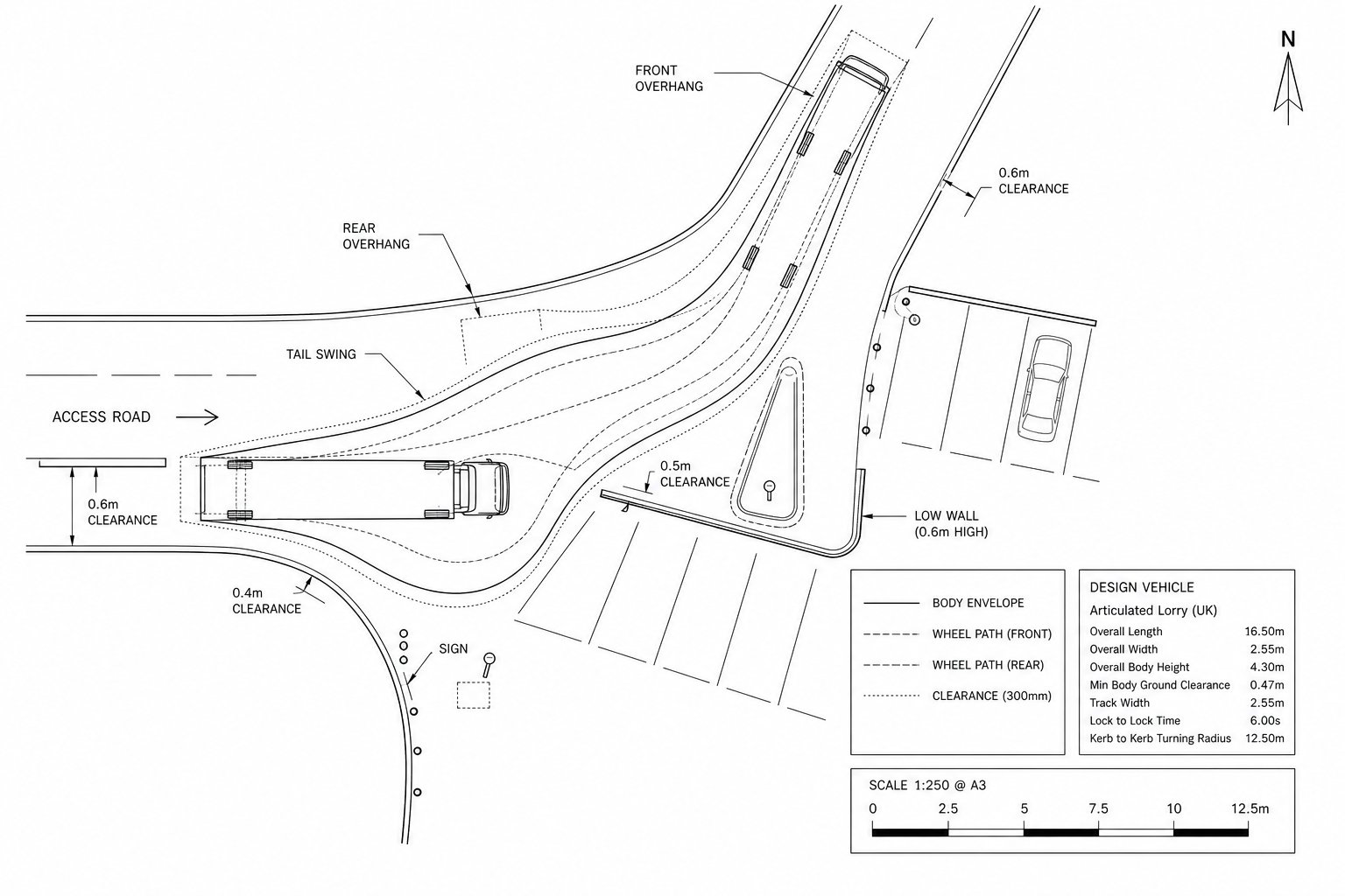
Swept path analysis is a technical assessment used to test whether a particular vehicle can move safely through a proposed or existing layout. It maps the route of the wheels and the outer body of the vehicle during a manoeuvre, showing where the front overhang, rear overhang and tail swing travel as the vehicle turns.
That matters because vehicles do not follow a single tidy line. The rear wheels track inside the front wheels, long vehicles swing wide, and even modest vans need more room than many early-stage layouts allow. A junction, internal estate road, service yard or car park aisle that looks generous at concept stage can prove too tight once an actual design vehicle is applied.
In traffic planning, this assessment helps us answer straightforward but critical questions:
- Can a refuse vehicle enter and leave in forward gear?
- Can an HGV reach the loading area without crossing into opposing traffic?
- Will a fire appliance clear the access bend?
- Do parked cars, kerbs or street furniture create conflicts?
The value is not just technical: it is strategic. A well-prepared vehicle tracking exercise can support road widths, bend radii, servicing arrangements and planning drawings before an application is submitted. It gives highways officers and case teams visual evidence that a layout is workable in practice, not just attractive in CAD.
That is one reason many applicants now treat swept path analysis traffic as a core part of a transport package rather than an afterthought added once objections arrive.
When A Swept Path Assessment Is Needed For A Planning Application
A swept path assessment is usually required whenever the safe movement of larger or less manoeuvrable vehicles is material to the acceptability of a scheme. In planning terms, that covers far more than industrial estates.
Common triggers include:
- new residential developments where refuse vehicles must enter the site:
- commercial schemes with delivery or servicing arrangements:
- care homes, schools or mixed-use sites with coach or minibus access:
- car parks with constrained circulation:
- new or altered site accesses onto the public highway:
- developments where emergency vehicle access is a condition or design issue.
We also find it useful where a local authority has concerns about turning heads, basement ramps, gated accesses, shared surfaces or internal corners. In those cases, the question is not whether a vehicle can theoretically fit, but whether it can manoeuvre safely and repeatably under normal operating conditions.
Planning officers and highway authorities often ask for swept path work where drawings alone leave room for doubt. And if a site is tight, irregular, listed, urban, or surrounded by existing buildings, the need becomes even stronger. A small geometry change can make the difference between a workable arrangement and one that relies on drivers performing unrealistic movements.
For applicants, the timing matters. If vehicle tracking is done early, it can inform the layout before problems are baked in. If left late, it tends to expose conflicts after the design team has already committed to parking numbers, landscaping or building footprints. In practice, that is why a concise Swept Path And Vehicle review often saves time during pre-app or submission-stage coordination.
Vehicles Commonly Tested In Swept Path Analysis
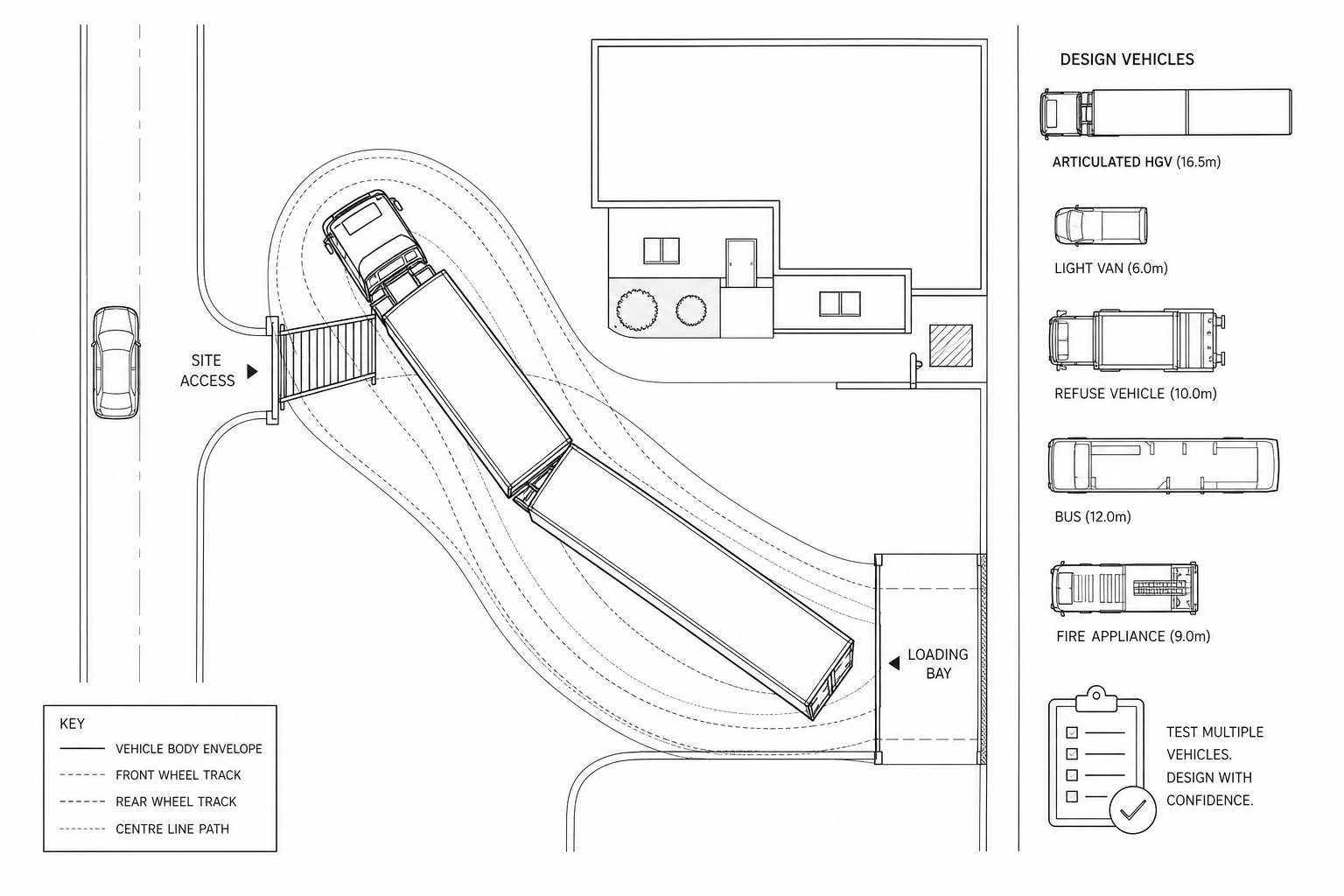
The right design vehicle depends on the land use, local authority expectations and the actual operation of the site. There is no universal template, and that is where some weak submissions go wrong: they test a vehicle that is convenient rather than realistic.
The most commonly assessed vehicles include:
- Cars for parking aisles, ramps and tight internal circulation
- Light vans for smaller service visits and residential access checks
- Refuse vehicles for housing schemes and mixed-use developments
- Rigid HGVs for servicing yards and medium-scale deliveries
- Articulated HGVs where larger logistics movements are expected
- Buses or coaches for education, leisure and public transport interfaces
- Emergency vehicles where fire access or operational access is relevant
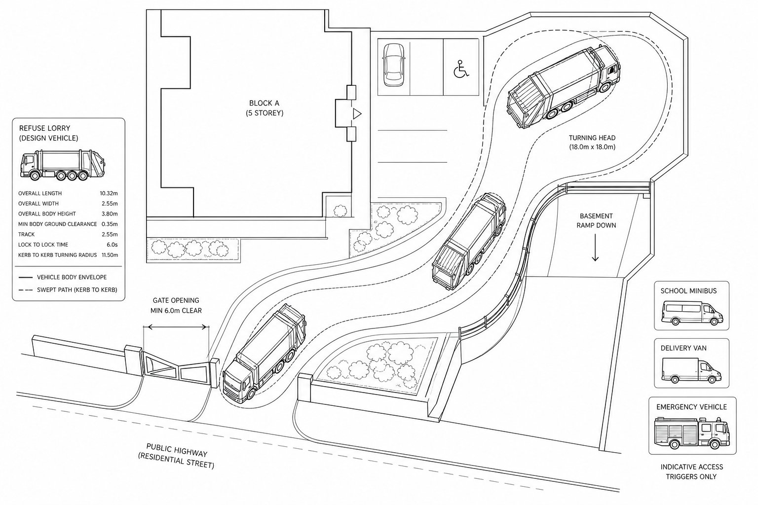
Many authorities and design teams pay particular attention to refuse vehicles, often around 11.2 metres, and articulated HGVs around 18.55 metres where freight access is relevant. But vehicle selection should never be guesswork. The correct approach is to confirm the likely operator type, collection method, servicing pattern and any authority-specific standards.
A suburban housing site, for example, may be driven mainly by refuse and fire access. A town-centre hotel might require coach set-down, delivery vans and emergency access checks. A trade counter or industrial unit may need rigid or articulated vehicle tracking at the gate, yard and loading bays.
In short, the chosen vehicle should reflect the site’s real use. If the wrong vehicle is tested, the analysis may look polished but still fail under scrutiny.
How Vehicle Tracking Works In Practice
In practice, vehicle tracking starts with a base drawing that is accurate enough to rely on. Engineers import the site layout into specialist software, select a design vehicle library entry or create a custom vehicle, and then simulate the manoeuvre through the proposed geometry.
The software calculates:
- wheel paths:
- body envelope:
- front and rear overhang:
- tail swing:
- clearance to kerbs, walls, bays, islands and street furniture.
That sounds straightforward, but good tracking is not just clicking a route through a plan. The operator has to apply sensible assumptions about steering behaviour, lane position, entry angles and repeatability. A “successful” movement that only works with a perfect one-off steering input is not much use in the real world.
We typically review whether the vehicle can complete the movement naturally, whether it stays within acceptable bounds, and whether any part of the route creates conflict with pedestrians, parked vehicles or opposing traffic. In constrained schemes, several iterations may be needed before the layout is workable.
Outputs are usually shown as plotted tracking curves over the site plan, often with separate colours for body and wheel paths. These drawings become part of the planning evidence base, helping all parties understand the practical implications of the design.
Where that evidence is presented clearly, it reduces ambiguity. Instead of debating whether a lorry “should probably fit”, the team can assess a visible, measurable manoeuvre.
Key Inputs That Affect The Accuracy Of A Swept Path Assessment
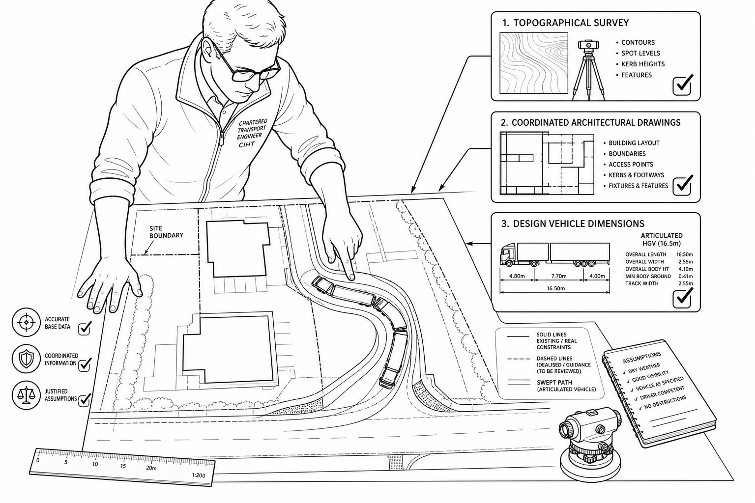
The reliability of a swept path assessment depends on the inputs. If the drawing is inaccurate, the vehicle is wrong, or the assumptions are unrealistic, the output may be technically neat but practically misleading. This is why highways reviewers often look past the coloured tracking lines and ask a harder question: were the inputs robust enough to trust?
A strong assessment is usually built on recent topographical information, coordinated architectural drawings and a clearly justified design vehicle. It also needs enough detail to capture the real constraints of the site rather than an idealised version of it.
Site Layout Geometry
Site geometry is the backbone of the exercise. Kerb lines, carriageway widths, radii, gate positions, parking bay depths, boundary walls, building corners, bins stores, islands, ramps and footways all affect the manoeuvre.
Even small discrepancies matter. A corner shown 300 mm differently on the drawing can alter whether a refuse truck clears a wall. A parking bay that projects slightly into an aisle may turn a comfortable movement into a repeated overrun. Street furniture, bollards, trees and visibility splays can also become critical pinch points.
This is especially important on constrained brownfield sites, town-centre infill schemes and retrofit developments where space is already spoken for. In those settings, we often find that a design appears compliant at a broad level but becomes awkward once every physical feature is mapped properly.
Good site geometry means using coordinated plans and checking that all disciplines are drawing the same thing. There is little value in a tracking plan prepared from an earlier revision if the architect has since shifted a wall, enlarged landscaping beds or altered parking.
Put simply: accurate geometry produces useful conclusions: approximate geometry produces arguments.
Vehicle Dimensions And Manoeuvring Assumptions
The other major variable is the vehicle itself, together with the assumptions used to drive it through the layout. Vehicle length matters, of course, but so do wheelbase, axle spacing, steering lock, body overhang and articulation characteristics.
A generic HGV may not represent the actual servicing vehicle likely to visit the site. Likewise, a refuse vehicle used by one authority or contractor may differ from another. Where local standards or operator details are available, those should guide the model.
Then come the manoeuvring assumptions. Was the vehicle allowed to use the full carriageway width? Was there opposing traffic? Were parked cars present? Is a reversing movement realistic in daily operation, or merely possible in an empty yard at low speed with no pressure?
This is where professional judgement really shows. A tracking result can be made to “work” by giving the driver ideal approach positions and unlimited road space, but highways officers will often challenge that if it does not reflect actual conditions.
For that reason, we prefer assumptions that are defendable, legible and proportionate. If a layout only succeeds under perfect circumstances, it probably needs redesign rather than a more optimistic drawing. A robust Swept Path And exercise should demonstrate practical operation, not just theoretical clearance.
Typical Manoeuvres Assessed On Development Sites
Most planning-related vehicle tracking focuses on a fairly consistent set of manoeuvres, though the exact combination depends on the development type. The aim is to test the key operational moments where geometry and vehicle movement collide.
On a residential site, that may centre on refuse collection and turning. On a commercial scheme, servicing and loading access may dominate. On larger mixed-use sites, we may need to consider access, circulation, set-down, emergency routes and service yard operations together.
The important point is that swept path analysis is rarely about movement in the abstract. It is about the manoeuvres that matter operationally and that planning officers are most likely to scrutinise.
Access And Egress
Access and egress checks test whether vehicles can enter from and leave to the public highway safely, without excessive overrun, awkward positioning or conflict with oncoming traffic and pedestrians.
This often involves more than simply proving that a vehicle can physically get through the gate. We need to understand approach angles, kerb radii, visibility, lane discipline and whether the driver has enough room to align naturally. A wide vehicle entering a narrow access may swing into the opposing lane. A vehicle exiting may have to edge out in a way that compromises footway safety or blocks the carriageway.
On constrained plots, the first few metres inside the site are often the hardest part. Gates, walls, level changes and immediate internal turns can create a sequence of movements that is technically possible but operationally poor.
For highways review, these are often among the most sensitive drawings because they affect not just the site user but everyone on the adjoining road network. If the access only works by taking excessive road width or mounting kerbs, the issue quickly becomes one of highway safety as well as layout design.
Turning, Servicing And Refuse Collection
Internal turning and servicing assessments look at what happens after a vehicle enters the site. Can it reach the loading point? Can it turn without repeated shunting? Can refuse collection take place in the expected manner? Can the vehicle leave in forward gear if that is the authority’s preference or requirement?
Refuse collection is a frequent pressure point on housing schemes. Bin store locations, parking courts and narrow internal roads can combine to leave too little room for a realistic collection movement. The result is often one of three problems: the vehicle cannot enter at all, it can enter but cannot turn, or it can turn only by overrunning kerbs and using areas not intended for vehicle movement.
Servicing yards have their own traps. Dock positions may be acceptable individually but fail once circulation is considered. Turning heads can look adequate until a parked van or a security island is included. And reversing routes need particular care: some are normal operational practice, others are exactly what a review should help eliminate.
These checks are often the difference between a layout that is merely drawable and one that can function day after day without ad hoc workarounds.
Common Design Problems Revealed By Swept Path Analysis
The biggest value of swept path analysis is often diagnostic. It reveals design issues early, while they are still fixable in a drawing package rather than on site.
Typical problems include:
- corners that are too tight for the selected vehicle:
- carriageways that are too narrow for turning movements:
- parking spaces that obstruct manoeuvring envelopes:
- loading bays that cannot be reached cleanly:
- gate positions that force excessive swing into the highway:
- layouts that require unsafe or impractical reversing:
- obstacles such as bollards, walls, trees or cabinets inside the tracking envelope.
Some of these problems are obvious once plotted. Others are subtler. A vehicle may clear a wall with millimetres to spare but do so only by taking the full width of a shared surface or clipping into pedestrian space. That may still be unacceptable.
Another recurring issue is overconfidence in nominal dimensions. Teams sometimes assume a standard width or radius will be enough because it has worked elsewhere. But site-specific constraints change everything: gradient, angle of approach, nearby parking, or a shifted boundary can all alter the outcome.
Done well, vehicle tracking does not merely identify failure. It points to solutions: adjust a kerb line, move a bay, widen a throat, relocate a store, or revise the servicing strategy. That is why it is so useful during design development, not just submission.
How Swept Path Analysis Supports Planning, Highways And Legal Teams
A swept path drawing is not just an engineering output. In planning and development work, it often becomes shared evidence across several disciplines.
For planning consultants and architects, it supports the credibility of the layout. It helps explain why road widths, corner radii, servicing areas and access positions have been chosen. For highway officers, it provides a visual, measurable basis for review rather than relying on assumptions from a general arrangement plan.
For legal teams, the value is slightly different. A robust manoeuvring assessment can help clarify whether a scheme is reasonably capable of operating as described, whether obligations tied to servicing or access are realistic, and whether technical concerns raised by third parties have objective foundation. On contentious schemes, that matters.
It also supports clearer communication. A planning case officer may not want a long technical note on turning geometry, but a clean tracking drawing can make the issue instantly understandable. Equally, where amendments are needed, the analysis shows exactly what changed and why.
At our end of the industry, speed matters too. Applicants often need concise, authority-aware reporting that aligns with local thresholds and planning expectations. That is where experienced transport input tends to make a real difference: not by adding complexity, but by producing evidence that is clear enough to withstand scrutiny and practical enough to keep the application moving.
What To Include In A Swept Path Analysis Report
A good swept path analysis report should be concise, clear and complete enough for a planning officer or highway reviewer to understand what was tested, why it was tested, and what the result means.
At minimum, we would expect it to include:
- the site address and development description:
- the purpose of the assessment:
- the base drawings and revision references used:
- the selected design vehicle or vehicles:
- a note on software methodology and assumptions:
- plotted tracking drawings for the relevant manoeuvres:
- commentary on clearance, overruns, reversing and operational practicality:
- any constraints identified:
- any design amendments made or recommended.
It also helps to explain the context. Why was that refuse vehicle selected? Is forward entry and exit required by policy or simply preferred? Were parking spaces assumed occupied? Was the access tested against realistic road conditions?
The best reports are not overloaded with jargon. They are visual, specific and defensible. If the manoeuvre works, the report should show that plainly. If it does not, it should identify the issue and the practical fix. That kind of clarity is what planners, developers and councils actually need.
Eventually, swept path analysis traffic is most useful when it answers the real planning question: can the site operate safely and credibly with the vehicles it is expected to serve? When a report does that well, it becomes far more than a technical appendix: it becomes part of the case for approval.
In 2026, that remains the standard worth aiming for, especially on sites where a single turning movement can decide whether a layout survives scrutiny.
Frequently Asked Questions about Swept Path Analysis Traffic
What is swept path analysis and why is it important in traffic planning?
Swept path analysis is a vehicle manoeuvring check used to confirm if a proposed site layout can safely accommodate designated vehicles without conflicts or overruns, ensuring road widths, bend radii and access geometry are practical for real-world use.
When is swept path analysis typically required for planning applications?
It is commonly needed when larger or specialised vehicles must access or circulate within a site, including for new residential developments needing refuse collection, commercial servicing, emergency access, or constrained car parks.
Which vehicles are most commonly assessed in swept path analysis traffic?
Typical design vehicles tested include cars, light vans, refuse collection trucks (around 11.2m), rigid and articulated HGVs (up to 18.55m), buses, coaches, and emergency vehicles depending on the site’s usage and local authority standards.
How does vehicle tracking software simulate vehicle manoeuvres for swept path analysis?
Engineers input accurate site plans and select design vehicles in specialist software that calculates wheel paths, body envelopes, front and rear overhangs, and tail swing to visualise the vehicle’s route through the layout, highlighting any conflicts or spatial issues.
What common design problems can swept path analysis reveal on development sites?
It often identifies tight corners, insufficient carriageway widths, obstructive parking bays, unreachable loading areas, gate positions causing excessive road encroachment, unsafe reversing routes, and conflicts with kerbs or street furniture.
How does swept path analysis support planning and highway teams during application reviews?
By providing clear, visual evidence of vehicle manoeuvring capability, it helps planning consultants, highway officers and legal teams verify that layouts are operationally sound, guiding design revisions and supporting approvals with measurable technical data.