A planning application can look perfectly sound on paper and still run into trouble once transport impacts come under scrutiny. We see it often: a scheme is commercially viable, policy-aligned in broad terms, and even well designed architecturally, yet progress slows because the likely effect on junctions, road safety, parking stress, or sustainable travel has not been worked through in enough detail.
That is where mitigation measures traffic issues become decisive. In planning terms, mitigation is not a box-ticking exercise or a late-stage drawing note. It is the practical package of interventions that makes a development acceptable in transport terms. If the residual cumulative impact on the road network would otherwise be severe, or if a proposal would undermine local policy objectives around safety, walking, cycling, or public transport, local authorities will expect robust evidence and proportionate solutions.
For architects, planners, lawyers, surveyors, developers and councils, the challenge is usually not whether mitigation exists, but whether it is properly evidenced, policy-led, deliverable, and capable of being secured through conditions or legal agreements. In this guide, we set out what traffic mitigation measures mean in a planning context, when they are typically required, and which strategies are most likely to help schemes move from objection to approval in 2026.
What Traffic Mitigation Measures Mean In A Planning Context
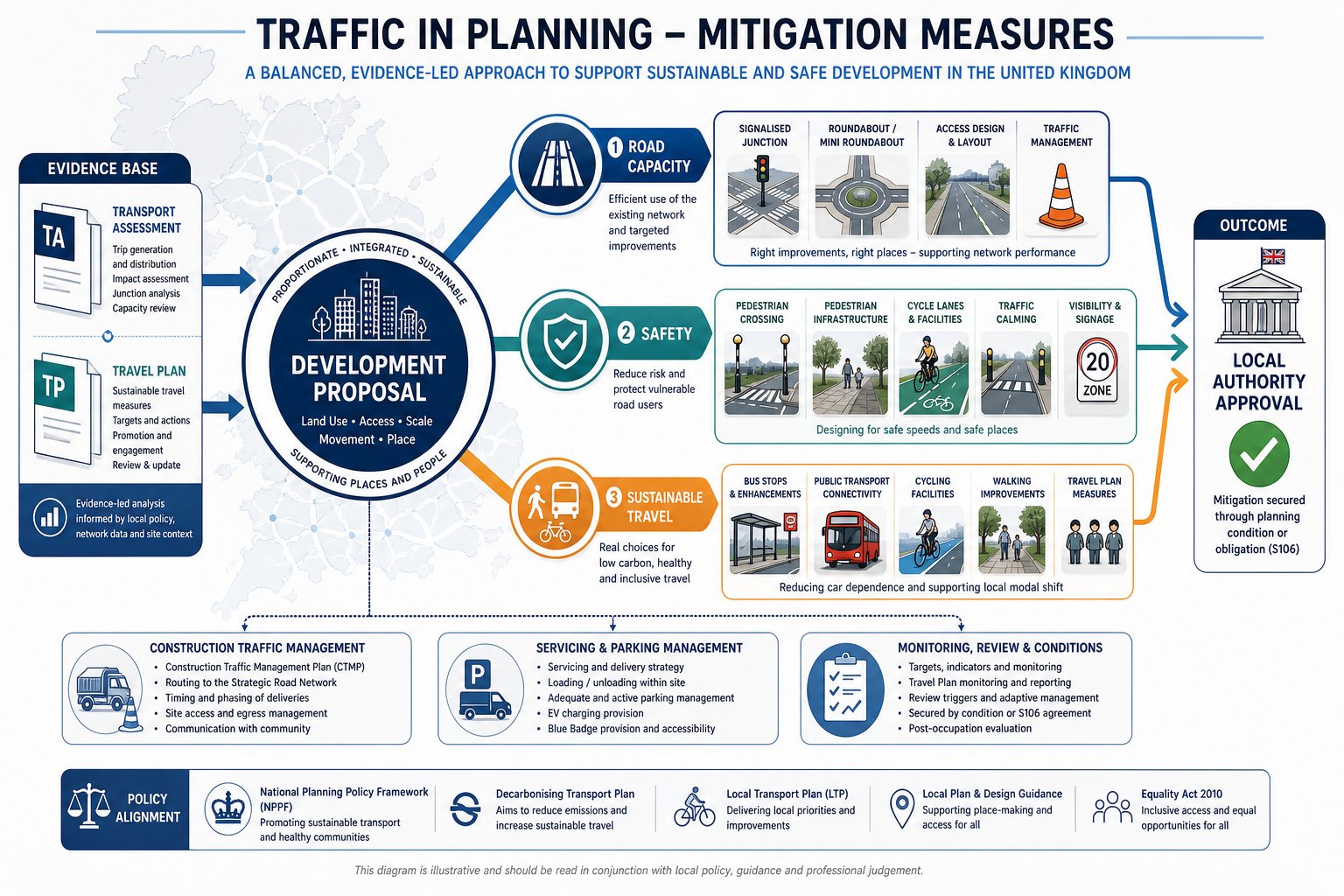
In planning, traffic mitigation measures are the interventions used to reduce or offset the transport impacts of development so that a proposal can operate safely and acceptably within the surrounding network. That can include physical highway works, changes to access arrangements, pedestrian and cycle improvements, bus-related measures, parking controls, or travel planning initiatives aimed at reducing car trips at source.
The key point is proportionality. Mitigation should respond to impacts that are identified through evidence, usually a Transport Assessment or Transport Statement, and it should do enough to address those impacts without drifting into unrelated infrastructure wish-lists. Local planning authorities and highway authorities are usually asking a fairly direct question: once this development is built and occupied, will the remaining transport effects still be acceptable?
In practice, good mitigation usually does three jobs at once:
- protects capacity where pressure is expected
- improves safety for all users
- supports policy goals around sustainable travel and decarbonisation
That matters because planning decisions are rarely based on congestion alone. A set of works that slightly improves queue lengths but does nothing for walking routes, crossing points, bus access or cycle storage may still feel incomplete. The strongest packages are balanced. They treat vehicle movement as one part of a wider transport system, not the whole story.
When Mitigation Is Required For A Development Proposal
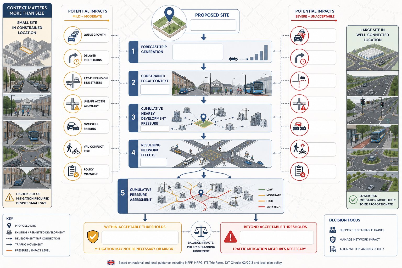
Mitigation is normally required when the forecast trips from a proposal would otherwise create unacceptable effects on the local or strategic network. Those effects may include longer queues at junctions, delayed right-turn movements, rat-running risk, unsafe access geometry, overspill parking, conflict with vulnerable road users, or a clear mismatch with adopted transport policy.
The trigger is not always the scale of a site on its own. Sometimes a modest scheme in a constrained location creates more planning concern than a larger site with excellent multimodal access. A few flats on a narrow road near a school entrance can generate sharper objections than a bigger mixed-use proposal next to a town-centre bus corridor. Context matters.
We also need to think cumulatively. Highway authorities will often review not just the trips from one site, but how those trips interact with committed development nearby. Underestimating this is a common weakness. Where a proposal sits in an area already experiencing pressure, even relatively modest extra demand can tip junction performance or parking conditions into something the authority considers unacceptable.
As a rule, mitigation becomes central when the evidence shows that without intervention the development would:
- worsen safety or visibility conditions
- materially increase delay or queueing
- undermine sustainable transport objectives
- create servicing, access or parking stress
- conflict with local plan or design policy requirements
At that point, mitigation stops being optional and becomes part of the planning case itself.
How Transport Assessments And Travel Plans Shape Mitigation
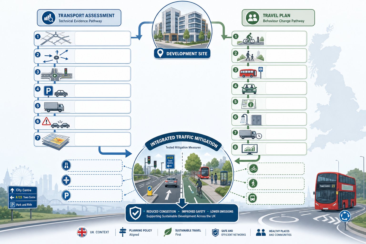
A Transport Assessment tells us what the development is likely to do to the network. A Travel Plan tells us how we can influence that outcome. Together, they shape the mitigation strategy.
The assessment side is the technical backbone. It usually covers trip generation, trip distribution, assignment, baseline traffic conditions, junction modelling, sustainable accessibility, accident records, servicing, parking demand and cumulative effects. If the analysis is robust, it gives us a realistic picture of where pressure will arise, when it will happen, and whether the impact is severe in policy terms. For many schemes, that is the point at which mitigation moves from broad discussion to tested options.
For residential and mixed-use sites, the quality of baseline assumptions matters hugely. Weak trip rates or generic assumptions can distort the whole package. That is why a properly scoped residential traffic impact study often makes the difference between a defensible strategy and a fragile one.
Travel Plans work differently. They target behaviour rather than geometry. Measures can include cycle facilities, welcome packs, public transport information, car-share promotion, subsidised bus travel, shower provision, freight management, delivery booking systems, and monitoring targets. On some sites, especially those with decent public transport or walkable catchments, these softer measures can materially reduce peak vehicle demand.
The best mitigation packages use both tools well: technical evidence to identify the problem, and targeted travel planning to reduce the need for engineering fixes alone.
Junction And Highway Capacity Improvements
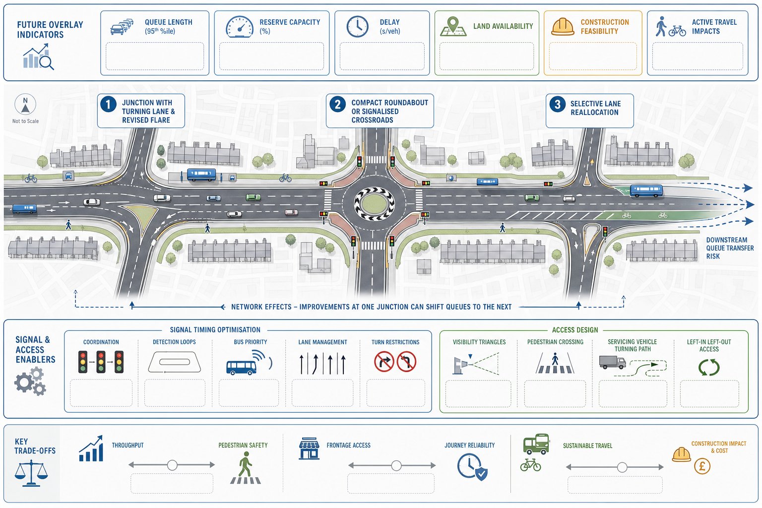
Junction and highway capacity improvements are often the most visible form of mitigation because they appear directly on plans and can be modelled with before-and-after outputs. Typical measures include added or lengthened turning lanes, revised flare lengths, new ghost islands, compact roundabouts, signalisation, carriageway widening, or selective reallocation of road space.
But capacity works should not be treated as the default answer. Extra width can improve one movement while worsening pedestrian crossing distance, increasing vehicle speeds, or creating downstream queue transfer. We have all seen schemes where one junction is “fixed” only for the bottleneck to move 150 metres along the corridor.
That is why the design objective should be corridor performance and network balance, not simply maximum throughput. In some locations, modest geometric changes combined with sustainable mode measures produce a better planning outcome than major widening works. In others, especially where there is a clear operational pinch point, physical junction improvement is unavoidable.
Authorities will usually expect evidence on:
- existing and forecast queue lengths
- reserve capacity and delay
- practical land availability
- stage-by-stage construction feasibility
- effects on active travel and frontage access
Where works extend beyond the red line, deliverability becomes just as important as technical benefit. A brilliant mitigation drawing that depends on third-party land, utility diversions and a two-year legal process is not, in truth, robust mitigation.
Signal Timing, Lane Allocation, And Access Design
Signal optimisation can be remarkably effective where spare green time exists or coordination between nearby junctions is poor. Revised staging, MOVA-style optimisation, queue-detection, bus priority, and better intergreens can all reduce delay without major civil works. Sometimes that is the smartest option because it is faster to deliver and less disruptive.
Lane allocation matters too. Reassigning approach lanes, extending storage, or tightening turn restrictions can improve operation where poor lane discipline is the real issue. Access design is equally important. A development access with weak visibility, awkward spacing from an existing junction, or unrestricted turning movements can undermine an otherwise acceptable proposal.
Good access design normally addresses spacing, radii, tracking, pedestrian priority, visibility splays, refuse and servicing movements, and whether all-turn access is actually necessary. In constrained urban settings, a left-in/left-out arrangement or a simpler priority access can sometimes work better than an overengineered solution.
Walking And Cycling Measures That Reduce Vehicle Demand
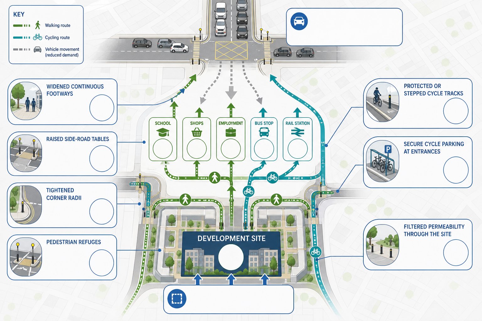
Some of the most effective traffic mitigation measures do not add road capacity at all. They reduce the number of vehicle trips that reach the junction in the first place.
Walking and cycling interventions are especially powerful where a site sits within realistic reach of schools, shops, employment, bus stops or rail stations. If people can leave the site comfortably on foot or by cycle, car dependence falls. Not dramatically overnight, perhaps, but enough to matter in peak periods.
The details are what count. Useful measures include:
- widened and continuous footways
- raised tables at side roads
- reduced corner radii to slow turning traffic
- pedestrian refuges on busier links
- protected cycle tracks or stepped facilities
- secure, convenient cycle parking near entrances
- filtered permeability through larger sites
We should be honest here: painting a few cycle symbols on a carriageway rarely changes behaviour. People respond to safety, directness and convenience. If the route to the local centre involves poor crossings, hostile turning traffic and awkward severance, mode shift forecasts will look optimistic.
That is one reason sustainable access analysis should be done early. A sound mitigation measures traffic strategy often starts with how people enter and leave on foot or by cycle, not with how many cars can be stacked at a junction. Authorities are increasingly alert to this, particularly where local plans and LCWIP-style priorities place active travel high on the agenda.
Public Transport Enhancements And Connectivity Measures
Public transport mitigation is sometimes overlooked because it can sit outside the highway engineer’s immediate focus. Yet for many schemes, especially larger residential, education, employment or mixed-use proposals, bus accessibility is central to whether car trip forecasts are credible.
Enhancements can range from relatively modest stop upgrades to more substantial interventions such as relocated stops, raised kerbs, shelters, real-time information, improved walking links to stops, bus gate access, queue-jump lanes, signal priority, or financial support for service improvements in the early years of occupation.
The planning question is simple enough: does the development make public transport a realistic everyday choice, or just mention it in the documents?
That depends on frequency, reliability, legibility and journey time. A stop within walking distance is not much use if crossing routes are poor or if buses get trapped in the same congestion the development is creating. This is where targeted bus priority can be more valuable than raw junction widening.
We also need to think about connectivity, not merely proximity. Can residents or staff reach key destinations without awkward interchange? Is there a safe and direct route to the station? Are timetable and occupation triggers tied together sensibly? Authorities will be far more receptive where enhancements are linked to measurable demand and secured clearly through conditions or obligations, rather than left as a vague aspiration.
Parking, Servicing, And On-Site Layout Changes
A surprising number of off-site traffic problems are generated by poor on-site planning. Parking stress, delivery conflicts, blocked aisles, awkward refuse movements and informal turning all spill onto the highway quickly.
That is why mitigation often starts inside the site boundary. Parking provision should reflect local standards, accessibility, likely car ownership, and the proposed tenure or land use mix. Too much parking can encourage vehicle demand: too little, in the wrong location, can push overspill into surrounding streets and trigger immediate neighbour objections. The right answer is usually more nuanced than either extreme.
Servicing deserves the same attention. If delivery vehicles cannot enter, turn, wait and leave safely, they will stop where they can. And where they can is often the worst possible place. Swept-path analysis, loading bay design, refuse collection arrangements, gate control, and internal routing all matter.
On larger sites, internal layout can also support mode shift by making walking and cycling the easiest choice. Direct pedestrian desire lines, overlooked routes, cycle hubs near entrances, and limited vehicle dominance around front doors all influence travel behaviour.
For planning teams preparing evidence, a focused residential traffic impact review often reveals that layout, parking management and servicing refinements can remove objections before more expensive off-site works are even discussed.
Construction Traffic And Temporary Mitigation Measures
Permanent mitigation is only half the story. A development can be acceptable in operation and still cause major short-term problems during demolition, enabling works and construction. Local authorities know this, and neighbours definitely know it.
Construction traffic mitigation is usually secured through a Construction Management Plan or Construction Logistics Plan. The aim is to control temporary effects on capacity, safety, amenity and road condition. Typical measures include approved HGV routes, delivery timing restrictions, marshalled access, temporary signage, wheel washing, contractor parking controls, holding areas, booking systems, and temporary traffic management around the site frontage.
Good plans are specific. They identify likely vehicle numbers, abnormal loads if relevant, school peak constraints, nearby sensitive receptors, banksman arrangements, and communication protocols with the highway authority. They also deal with the awkward practical questions that often spark complaints: where do vehicles wait, what happens if they arrive early, and how do pedestrians pass safely when the gate is busy?
For complex urban sites, temporary mitigation may need phased road orders, footway diversions, bus stop relocation or signal amendments during works. If so, those dependencies should be acknowledged early. A neat sentence saying “details to follow” rarely reassures a planning officer when the route is already congested and politically sensitive.
Road Safety, Visibility, And Speed Management Measures
Safety-led mitigation is often where transport objections become most serious. If a proposal introduces intensified use of a substandard access, worsens turning conflict, or places more vulnerable users into an already hostile environment, planning risk rises quickly.
The response may involve visibility improvements, access realignment, localised widening, removal of roadside obstructions, improved street lighting, formal crossing points, gateway features, speed cushions, tables, chicanes, lane narrowing, or signed and lined changes that clarify priority. In village and edge-of-settlement locations, speed management is often central because posted limits do not always reflect actual driver behaviour.
A useful principle here is that safety mitigation should match the mechanism of risk. If collisions are linked to speed, tackle speed. If they are linked to poor crossing opportunity, improve crossing provision. If they arise from confusing access arrangements, simplify the geometry. Throwing generic traffic calming at the issue can create fresh problems if the evidence base is thin.
Authorities will often review recent collision data, site visibility, recorded speeds, pedestrian desire lines, school routes and audit findings. A road safety audit does not replace planning judgement, but it can expose details the broader assessment misses. And sometimes it is the small things that determine acceptability: a tighter radius, a refuge in the right place, or a few metres of unobstructed visibility.
How Local Authorities Assess Whether Mitigation Is Acceptable
Local authorities do not assess mitigation on a single metric. They weigh a package against policy, evidence, engineering practicality and legal certainty.
First, they look at performance. Does the proposal, with mitigation in place, keep queues, delay and network effects within an acceptable range? The answer is not always a perfect number. Planning is more rounded than that. But if residual impacts remain clearly severe, approval becomes difficult.
Second, they look at safety. Access visibility, pedestrian movement, cycling conditions, servicing conflict and speed environment all feed into the judgement. A mitigation package that improves capacity but worsens active travel conditions may struggle, especially under current policy emphasis on sustainable and inclusive movement.
Third, they look at compliance and deliverability. Is the package aligned with local transport policy, climate objectives, design guidance and place-making aims? Can it be funded, designed and built when needed? Is land control in place? Are trigger points sensible? Can outcomes be monitored?
This is where experienced reporting helps. At ML Traffic, our approach is to match mitigation to local authority thresholds and planning context rather than dropping in generic wording. That tends to produce shorter negotiations, because officers can trace the line from evidence to impact to intervention to securing mechanism.
In practical terms, acceptable mitigation is usually mitigation that is:
- evidence-based
- proportionate to impact
- feasible to deliver
- properly secured
- monitored where behaviour change is relied upon
Common Mistakes That Weaken A Mitigation Strategy
The most common mistake is relying on capacity increases alone. Extra lane space can be necessary, but if the site has poor walking links, weak cycle access and no credible public transport strategy, the package can look one-dimensional and policy-light.
Another frequent problem is optimistic forecasting. If trip rates are understated, distribution assumptions are convenient rather than realistic, or cumulative development is brushed aside, every mitigation conclusion built on that base becomes vulnerable. Highway authorities spot this quickly.
We also see strategies that are technically sound but procedurally weak. Works are described, but not secured. Funding is implied, but not identified. Triggers are too vague. Off-site land is needed, but control is uncertain. Travel Plan measures are ambitious, yet monitoring and remedial mechanisms are missing. In planning terms, that is often fatal.
Other weak points include:
- poor integration between transport and site layout teams
- non-car measures added too late to be effective
- generic Travel Plans with no local tailoring
- ignoring servicing and refuse operations
- failing to test temporary construction effects
- presenting mitigation as fixed before officer feedback is considered
The stronger approach is iterative. We should test, refine, discuss with the authority, and make sure the final package is both technically credible and realistically deliverable. That sounds obvious, but in live planning programmes it is exactly where schemes can wobble.
Conclusion
Traffic mitigation is rarely about one drawing or one junction fix. For planning applications in 2026, the schemes that stand up best are the ones that combine network efficiency, road safety and sustainable travel in a single, evidence-led package.
That means starting early, scoping properly, and using the Transport Assessment and Travel Plan as genuine decision-making tools rather than supporting paperwork. It also means being realistic: some impacts need physical works, some need demand management, and many need both.
When mitigation is proportionate, policy-aware, deliverable and properly secured, it does more than answer consultee comments. It helps turn a development into something the authority can support with confidence. And in a tighter planning environment, that can be the difference between delay and permission.
Traffic Mitigation Measures FAQs
What are traffic mitigation measures in planning and why are they important?
Traffic mitigation measures are interventions designed to reduce or offset the transport impacts of a development, ensuring safe operation within the existing network. They protect capacity, improve safety, and support sustainable travel policies, helping developments gain planning approval.
When are traffic mitigation measures typically required for a development proposal?
Such measures are needed when a development’s forecast trips would cause unacceptable congestion, safety issues, parking problems, or conflict with local transport policies, as demonstrated by a detailed Transport Assessment or Transport Statement.
How do Transport Assessments and Travel Plans influence traffic mitigation strategies?
Transport Assessments quantify trip generation and network impacts, identifying where mitigation is needed. Travel Plans aim to reduce car trips through behaviour change measures like promoting cycling or public transport, helping shape balanced and effective mitigation packages.
What types of walking and cycling measures can reduce vehicle demand around a development?
Effective measures include widened footways, raised crossings, pedestrian refuges, protected cycle tracks, and secure cycle parking. These improve safety and convenience, encouraging mode shift away from car use and reducing congestion and parking pressures.
How do local authorities judge the acceptability of traffic mitigation measures?
Authorities assess if the mitigation keeps network performance and safety within acceptable levels, aligns with policies on sustainable travel and climate, is feasible, proportionate, properly secured, and monitored to ensure it delivers intended outcomes.
What common mistakes weaken a traffic mitigation strategy?
Common errors include relying solely on capacity improvements, underestimating trips or cumulative effects, neglecting non-car modes, failing to secure or fund measures properly, and presenting mitigation without iterative engagement with authorities.