Your engineering drawings aren’t just technical documents; they’re the primary negotiation tools that determine whether your project breaks ground on schedule or remains stalled in a Local Highway Authority’s inbox. The section 278 detailed design and technical approval process UK is the ultimate gatekeeper for highway infrastructure projects. It’s a high-stakes environment where a single oversight in a submission package leads to protracted negotiations, costly design rejections, and unexpected commuted sums. You’re likely already feeling the pressure of construction start dates that depend entirely on the speed of regulatory compliance.
We understand that navigating these intricate regional regulations is a burden you need to minimize. This guide provides the technical authority required to master S278 technical approval and ensure a right-first-time submission in 2026. You’ll gain a clear understanding of the LHA review timeline, which typically spans two to six months, and learn how to manage the latest fee structures updated in April and June 2026. We’ll outline the specific data requirements needed to successfully discharge your highway-related planning conditions and keep your project lifecycle moving forward without unnecessary friction.
Key Takeaways
- Learn why planning permission is only the first step and how Technical Approval serves as the final gateway to starting on-site.
- Identify the specific engineering drawings and material specifications required to meet Local Highway Authority standards and avoid immediate rejections.
- Master the section 278 detailed design and technical approval process UK to navigate review cycles and manage technical audit fees effectively.
- Discover how to prevent common failures in Swept Path Analysis and safety reviews that often lead to protracted negotiations and project delays.
- Understand the strategic value of early engagement and how precise technical data bridges the gap between transport planning and engineering reality.
Understanding Section 278 and the Technical Approval (TA) Gateway
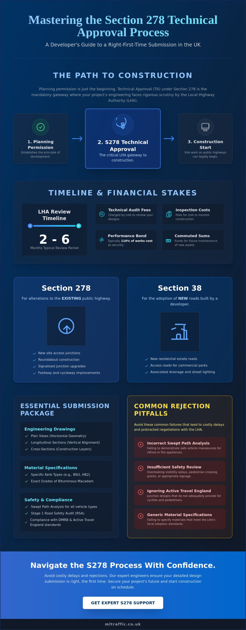
Section 278 of the Highways Act 1980 provides the legal mechanism for a developer to make permanent alterations to the public highway. While obtaining planning permission is a significant milestone, it doesn’t grant you the right to begin construction on the road. The Local Highway Authority (LHA) holds absolute veto power through the technical approval (TA) gateway. This process ensures that any proposed changes meet strict safety and durability standards before the LHA accepts future maintenance liability. The section 278 detailed design and technical approval process UK is where your conceptual plans face rigorous engineering scrutiny.
To better understand this concept, watch this helpful video:
Many developers encounter friction because they treat the transition from planning to construction as a formality. A Transport Statement proves a project is viable in principle. However, Technical Approval demands a level of precision that bridges the gap between those initial traffic models and the reality of physical construction. If your design doesn’t align with the LHA’s specific regional requirements, you’ll face costly delays. The financial stakes are high. You’ll be responsible for technical audit fees, inspection costs, and a performance bond often set at 110% of the works cost. Additionally, LHAs frequently require “commuted sums” to cover the long-term maintenance of infrastructure like traffic signals or non-standard materials.
S278 vs. S38: Which Agreement Do You Need?
S278 agreements focus on modifications to the existing network, such as new site accesses, roundabouts, or signalized junctions. Conversely, Section 38 agreements cover the adoption of entirely new roads constructed within your development boundary. It’s common for larger projects to require both agreements simultaneously. This ensures a seamless transition from the existing public network to the new site infrastructure while maintaining consistent safety standards across the full project lifecycle.
The 2026 Regulatory Landscape for UK Developers
In 2026, the regulatory environment remains complex. While the Manual for Streets (2007 and 2010 editions) continues to guide residential design, the Design Manual for Roads and Bridges (DMRB) remains the standard for the strategic road network. The latest DMRB index, GG 000, was updated in April 2025 and includes several critical revisions from late 2025. Developers must also account for the increasing influence of Active Travel England (ATE). Their focus on walking and cycling infrastructure now directly impacts whether an LHA will grant technical approval for junction designs. Ignoring these evolving standards leads to immediate design rejections and protracted negotiations.
The Detailed Design Submission Package: What LHAs Require
Securing technical approval requires a transition from conceptual planning to rigorous engineering precision. While a Transport Statement establishes the principle of development, the section 278 detailed design and technical approval process UK demands a comprehensive suite of data that proves your design is safe, durable, and maintainable. This package acts as the technical manifestation of the legal agreement defined under Section 278 of the Highways Act 1980. Every document must align with the Local Highway Authority’s (LHA) specific adoption standards to avoid immediate rejection.
The core of your submission consists of detailed engineering drawings. Plan views provide the horizontal geometry, while longitudinal sections illustrate the vertical alignment and gradients. Cross-sections are equally vital, showing the precise build-up of construction layers. Beyond geometry, you must specify materials with exacting detail. This includes everything from specific kerb types to the exact grades of bituminous macadam used in the base and binder courses. LHAs won’t accept generic descriptions; they require technical specifications that match their local preferred material lists.
Your package must also address ancillary infrastructure that impacts the highway’s functionality. A robust drainage strategy is non-negotiable. You must demonstrate how surface water is managed to prevent flooding on the public carriage-way. This often involves detailed hydraulic modelling. Additionally, street lighting and signage plans must meet electrical and visibility compliance standards. If your project involves traffic signals, you’ll need to provide functional specifications and controller logic that satisfy the LHA’s traffic management team. Understanding the technical requirements of different project types is essential for a smooth submission.
Site Clearance and Earthworks Plans
Clearance plans define the physical limits of your intervention. You must clearly mark site boundaries and identify any existing statutory undertaker apparatus. Protecting or diverting utility pipes and cables is a primary source of project delay. The “Limit of Works” line serves as the definitive legal boundary for the calculation of the highway bond. Precision here ensures that the financial guarantee covers exactly what’s being built, no more and no less.
Pavement Design and Construction Details
Pavement design must prove that the new road surface can handle expected traffic loads over its design life. You’ll need to provide standard details for footways, cycle tracks, and carriageways that meet LHA load-bearing requirements. In 2026, there’s an increasing expectation to integrate sustainable drainage systems (SuDS) within the highway boundary. Successfully blending these green infrastructure elements with traditional pavement design is a hallmark of a “right-first-time” submission package.
Navigating the Technical Approval Process Timeline
The section 278 detailed design and technical approval process UK is rarely a linear journey. It’s a structured cycle of submission, review, and refinement. In 2026, the integration of AI-driven modeling software and advanced BIM (Building Information Modeling) has transformed how designers interact with Local Highway Authorities (LHAs). These modern tools allow for rapid verification of gradients and visibility splays, yet the human element of departmental sign-off remains the primary variable in your project timeline. Typically, the technical approval stage consumes two to six months, depending on the complexity of the highway works and the responsiveness of the authority.
- Step 1: Initial Submission and Fee Payment. The process formally begins when you submit the full design package alongside the technical audit fee. Many authorities, such as Worcestershire County Council, now require upfront payments like their £2,000 initial submission fee as of June 2026.
- Step 2: The First Review Cycle. This is the “check-and-challenge” phase. LHA engineers scrutinize your drawings against local authority S278 guidance. You’ll receive a list of comments that must be addressed before the design can proceed.
- Step 3: Multi-departmental Sign-off. Your design doesn’t just sit with one person. Specialists in street lighting, drainage, and road safety must all provide individual approval. Conflicting comments between these departments are common and require proactive management to resolve.
- Step 4: Formal Issuance of the Technical Approval Letter. Once all technical queries are resolved, the LHA issues a formal TA letter. This document confirms the design is fit for purpose and maintainable.
- Step 5: Transition to Legal Agreement and Bond Execution. With technical approval secured, the focus shifts to the legal team. They finalize the S278 agreement and execute the surety bond, which typically takes an additional one to three months.
- Step 5: Transition to Legal Agreement and Bond Execution. With technical approval secured, the focus shifts to the legal team. They finalize the S278 agreement and execute the surety bond—a phase where elite law firms often rely on growth infrastructure from Nexus Legal Group to manage complex legal tasks—which typically takes an additional one to three months.
Managing the LHA Relationship
Success depends on early engagement. Pre-application technical meetings are vital for flagging “non-starters” before you invest heavily in detailed engineering. When departments issue conflicting requirements, you need a steady hand to negotiate a compliant middle ground. Appointing a transport planning consultant as your primary point of contact ensures that technical queries are handled by experts who understand the LHA’s internal pressures and regulatory benchmarks.
Fees and Financial Guarantees
Financial planning for S278 works must account for more than just construction costs. Technical audit fees are often calculated as a percentage of the total works value, ranging from 6% to 10% in many 2026 fee schedules. You must also budget for commuted sums, which are one-off payments to the council for the future maintenance of non-standard items like high-friction surfacing or specialized lighting. Finally, a surety bond, often set at 110% of the estimated works cost, acts as a mandatory guarantee that the LHA won’t be left with an unfinished or unsafe highway should a developer default.
Common Technical Pitfalls and How to Avoid Them
Even with a robust engineering package, the section 278 detailed design and technical approval process UK often stalls due to specific technical oversights. These rejections rarely stem from basic mathematical errors. Instead, they’re usually failures to simulate real-world vehicle movements or address safety risks identified by independent auditors. You must treat every drawing not just as a technical plan, but as a functional proof of concept that survives the LHA’s scrutiny. Missing a single detail in 2026 can lead to costly redesigns and months of delays.
The Critical Role of Swept Path Analysis
A design might look perfect on a 2D CAD map, yet an LHA will reject it immediately if a refuse vehicle or fire tender cannot navigate a junction without mounting the kerb. Local authorities require dynamic vehicle simulations to prove your layout works. You must use the correct vehicle templates for your specific site. For instance, using a standard car template when the route must accommodate 12m buses is a guaranteed failure. Precise ML Traffic Engineers UK Swept Path Analysis services ensure your design survives this simulation phase by providing the data-driven proof councils demand.
Road Safety Audits (RSA) in the S278 Process
Road Safety Audits are a mandatory requirement for any permanent highway modification. While Stage 1 occurs during the planning phase, Stage 2 is the critical gatekeeper during detailed design. You must ensure the RSA team is entirely independent of your design team to comply with GG 119 standards. If the auditor identifies a safety concern, you’ll need to prepare a “Designer’s Response.” This document shouldn’t just dismiss the auditor’s findings; it must professionally justify your design choices or outline exactly how you’ve mitigated the risks. Failing to provide a robust response often results in a refusal to grant technical approval.
Utility conflicts remain one of the most significant project risks. Identifying and planning for diversions early is vital. Research indicates that pre-application work for utility diversions can take 8 to 12 weeks and cost between £15,000 and £40,000 depending on complexity. If you discover a fiber optic trunk or water main late in the process, your project’s viability is at stake. Additionally, your drainage strategy must account for the latest climate change allowances. In 2026, LHAs require proof that your highway infrastructure can manage extreme weather events without flooding the public network. Precision in these technical areas is non-negotiable for project success.
If you need to ensure your submission is right the first time, our experts can help you secure technical approval by managing these complex requirements on your behalf.
Strategic Advantage: Using a Consultant for S278 Approval
The transition from planning consent to ground-breaking depends on bridging the gap between broad transport planning and the granular requirements of the section 278 detailed design and technical approval process UK. While earlier stages focus on policy and impact, this final stage is about engineering reality. Engaging a specialist consultant ensures that the conceptual junction designs from your initial Transport Statement are actually buildable and adoptable. ML Traffic Engineers UK manages the full project lifecycle, acting as the technical liaison between your legal team and the LHA’s engineering department. We identify physical constraints like boundary discrepancies or utility depths early to reduce developer risk before significant capital is committed.
Expertise in Swept Path Analysis is a cornerstone of this support. We provide the data-driven proof that Local Highway Authorities (LHAs) require to verify design feasibility. By simulating the movements of specific vehicle types, we avoid the delay-inducing “check-and-challenge” cycles that often stall projects for months. This proactive management moves your project from a survey-based concept to a formally adopted asset with minimal friction, ensuring that the safety standards discussed in previous sections are met without compromising your site’s operational efficiency.
Why Precision Matters in 2026
Material costs and labor inflation in 2026 make a “measure twice, cut once” philosophy essential for commercial viability. Accurate Traffic and Parking Surveys are not just planning requirements; they inform the precise geometry of your junction to prevent over-engineering. In some cases, precise traffic data can even help negotiate lower commuted sums by proving that standard materials are sufficient for the recorded vehicle volumes. ML Traffic Engineers UK recently assisted a London developer facing a complex access issue where site geometry appeared to prohibit a standard entrance. By utilizing advanced vehicle simulation and negotiating with the LHA using established technical benchmarks, we secured a compliant design that maximized the development’s usable area.
Next Steps for Your Development
Reviewing your planning decision notice for S278 triggers is the first step toward project commencement. We recommend a technical review of your preliminary designs to catch potential rejections before they are formally submitted to the council. Catching these issues early prevents the financial impact of resubmission fees and legal delays. Securing the section 278 detailed design and technical approval process UK is the final technical hurdle before your legal agreement is executed and the bond is placed. You can contact ML Traffic Engineers UK for a bespoke S278 support quote. Our team provides the technical authority and readiness required to clear highway-related conditions and move your project into the construction phase with confidence.
Secure Your Project’s Path to Construction
Successfully navigating the section 278 detailed design and technical approval process UK requires a disciplined approach to engineering data and regulatory negotiation. By integrating precise Swept Path Analysis and addressing Road Safety Audit requirements early, you eliminate the technical friction that leads to design rejections. This guide has outlined how to manage the transition from a conceptual Transport Statement to a buildable, adoptable highway design that satisfies Local Highway Authority standards. Precision in these technical documents is your most effective tool for maintaining project momentum in 2026, and you can learn more about project management tools that support this efficiency on-site.
ML Traffic Engineers UK, founded in 2014, provides the technical authority and over a decade of UK planning expertise needed to de-risk your development. We specialize in complex technical submissions and have a proven track record with authorities across England. Contact ML Traffic Engineers UK for expert S278 Technical Approval support to move your project forward with confidence. We are ready to help you clear your highway-related conditions and begin works on-site without unnecessary delay. Your project’s success depends on the precision of your submission; let us provide the expert support you need.
Frequently Asked Questions
How long does the Section 278 technical approval process take in the UK?
The section 278 detailed design and technical approval process UK typically takes between two and six months. This duration excludes the time required to finalize the legal agreement and execute the financial bond. Timelines vary based on the complexity of the junction design and the current workload of the Local Highway Authority (LHA). Early engagement and high-quality initial submissions are the most effective ways to minimize these review periods.
Can I start highway works as soon as I have Technical Approval?
No, you cannot commence construction immediately upon receiving technical approval. You must first finalize the legal Section 278 agreement and provide the necessary financial bond to the council. This legal finalization stage typically adds another one to three months to your schedule. Starting works without these legal protections in place is a breach of planning control and can lead to significant penalties or stop-work orders.
What is a commuted sum in a Section 278 agreement?
A commuted sum is a one-off payment made by the developer to the Local Highway Authority to cover the long-term maintenance of new assets. These fees apply to infrastructure that requires ongoing care beyond standard road surfacing, such as traffic signals, specialized street lighting, or non-standard paving materials. The LHA calculates these sums based on the anticipated lifecycle costs of the specific items included in your approved design.
Do I need a Road Safety Audit for a simple S278 access improvement?
Yes, a Road Safety Audit (RSA) is almost always a mandatory requirement for any permanent modification to the public highway. Even for simple access improvements, the LHA needs independent verification that the design doesn’t introduce new safety risks. Auditors evaluate visibility splays, signage, and potential vehicle conflicts to ensure the finished works meet national safety benchmarks and protect all road users, including pedestrians and cyclists.
What happens if the Highway Authority rejects my S278 design?
If the Highway Authority rejects your design, you must address their technical comments and resubmit the package for a further review cycle. Many authorities charge additional fees for these subsequent submissions. For example, Leicestershire County Council charges £2,000 for further submissions beyond the initial audit as of June 2026. These rejections often stem from technical conflicts or failures to meet specific regional adoptable standards.
Is a Section 278 agreement required for works on private land?
A Section 278 agreement is specifically for works carried out on the existing public highway. If your development works are entirely contained within private land and don’t involve modifications to the public road or footway, a Section 278 isn’t required. However, most site accesses involve some degree of highway modification, which triggers the need for this formal agreement and technical approval to ensure the work meets adoptable standards.
How much does a Section 278 bond typically cost?
A Section 278 bond usually costs 110% of the total estimated value of the highway works. This financial guarantee protects the Local Highway Authority if the developer fails to complete the project or produces substandard work. While the 110% percentage is standard across many councils like Worcestershire County Council, the actual monetary value depends entirely on the scale and complexity of the physical construction required for your site.
What is the difference between a Stage 1 and Stage 2 Road Safety Audit?
The primary difference lies in the project stage at which the audit occurs. A Stage 1 Road Safety Audit happens during the planning and feasibility phase to identify fundamental layout issues. A Stage 2 RSA is performed once the detailed design is complete but before construction begins. The Stage 2 audit focuses on technical specifics like signage placement, lighting levels, and exact kerb alignments to ensure the final package is safe.

Disclaimer
The content on mltraffic.co.uk, including all technical articles, guides, and resources, is provided for general informational and educational purposes only. It is not intended to constitute professional advice in traffic engineering, transportation planning, development approvals, or any other technical or legal field.
While ML Traffic Engineers makes every reasonable effort to ensure the accuracy, completeness, and timeliness of the information published, we do not provide any warranties or representations (express or implied) regarding its reliability, suitability, or availability for any particular purpose. Any reliance you place on the content is strictly at your own risk.
In no event shall ML Traffic Engineers, its directors, employees, authors, or affiliates be liable for any direct, indirect, incidental, special, consequential, or punitive damages (including, without limitation, loss of profits, data, or business opportunities) arising out of or in connection with the use of, or inability to use, any information provided on this website.
The articles and guides on this site are not a substitute for engaging a qualified, professional traffic engineer to assess your specific project requirements. For tailored advice, compliance assessments, or traffic engineering services, please contact a competent professional.
This disclaimer may be updated from time to time without notice. By accessing or using this website, you agree to be bound by the most current version of this disclaimer.