A planning application can look perfectly sound on paper and still run into trouble the moment highways comments come back. We’ve all seen it: a scheme with commercial promise, a sensible layout, even broad policy support, but then questions land about junction capacity, queueing, access safety, or whether the local network can actually absorb the extra traffic. That’s where a Traffic Impact Assessment, or TIA, stops being a technical afterthought and becomes a project-critical document.
For developers, architects, planners, surveyors, and local authorities, a good TIA does more than count cars. It explains how a development will function in the real world. It shows whether traffic effects are acceptable, what mitigation is needed, and how transport evidence aligns with the design, phasing, and planning strategy. Done early, it can save redesign time, reduce objections, and prevent expensive late-stage surprises.
In 2026, expectations are if anything tighter: local thresholds are more closely applied, modelling assumptions are scrutinised, and supporting transport evidence needs to be clear, defensible, and tailored to the site. In this guide, we set out what traffic impact assessment developers need to understand, when a TIA is typically required, what authorities usually expect, and how to keep the planning process moving rather than stalling over avoidable transport issues.
What A Traffic Impact Assessment Means For Developers
A Traffic Impact Assessment is a technical study that tests how a proposed development will affect the surrounding highway network and what should be done if those effects are material. For developers, that usually means answering a few practical questions early: will the roads and junctions still operate acceptably, will the access work safely, and will off-site improvements or contributions be needed?
That matters because transport concerns can alter a scheme far beyond the highway boundary. A weak assessment can trigger redesign, added conditions, delayed determination, or refusal. A strong one gives the project team something much more useful: evidence. It helps us understand whether a site access is in the right place, whether phasing is realistic, whether a signal upgrade is likely to be requested, and whether the planning case is vulnerable at committee or appeal.
For developers in particular, the value of a TIA is risk control. It turns transport from a vague planning concern into a defined workstream with a scope, programme, assumptions, and mitigation path. And when it’s aligned with wider Property Development Transport Advice:, it often saves far more time and cost than it adds.
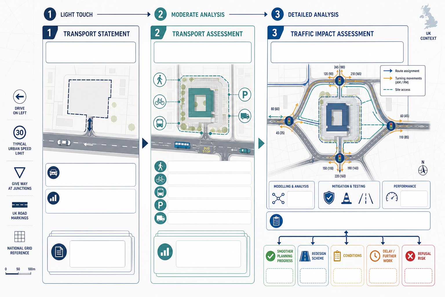
How A Traffic Impact Assessment Differs From A Transport Statement And Transport Assessment
A Transport Statement, Transport Assessment, and Traffic Impact Assessment are related, but they are not interchangeable.
A Transport Statement (TS) is usually the lightest-touch document. It suits smaller developments where transport impacts are expected to be limited. It may summarise site accessibility, existing conditions, and likely trip effects without detailed modelling.
A Transport Assessment (TA) is broader. It covers multi-modal transport matters: walking, cycling, public transport, travel patterns, parking, servicing, and wider accessibility as well as traffic. For larger or more complex schemes, the TA often becomes the main transport evidence base.
A Traffic Impact Assessment (TIA), sometimes called a Traffic Impact Study, is more specifically focused on vehicular effects. It tends to involve detailed capacity analysis, turning counts, trip distribution, route assignment, and junction modelling. In practice, a TIA may sit within a TA or be submitted alongside one.
The distinction matters because authorities usually expect the level of evidence to match the scale and sensitivity of the scheme. Calling something a statement when it really needs network analysis rarely ends well.
When A Traffic Impact Assessment Is Required For A Planning Application
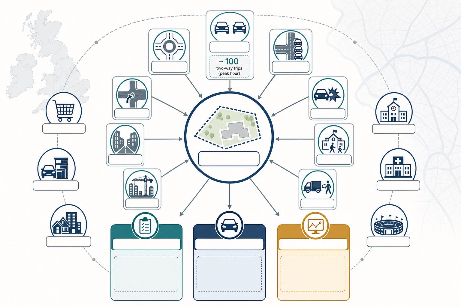
There isn’t a single national trigger that applies to every site in exactly the same way, which is why developers sometimes get caught out. In general, a TIA is required where a proposal is likely to create significant traffic effects, put pressure on sensitive junctions, alter access arrangements, or raise local highway safety concerns. A commonly used rule of thumb is around 100 two-way peak-hour vehicle trips, but that is only a guide, not a universal pass-fail test.
In reality, local planning authorities and highway authorities rely on their own validation requirements, transport guidance, and network knowledge. A scheme below 100 peak-hour trips may still need a TIA if it sits on a constrained urban corridor, beside a school, near a poor accident record, or on an already stressed roundabout. Equally, some lower-impact proposals may justify a more proportionate submission.
That’s why we usually advise scoping the requirement before the application strategy hardens. Early transport input helps determine whether a concise statement is enough, whether a full TA is needed, or whether traffic modelling will be central to the planning case. On more complex sites, specialist support from a Traffic Engineer In Manchester: or an equivalent local consultant can be the difference between a clean submission and a prolonged highways debate.
Typical Development Types And Triggers That Lead To A TIA
Some development types repeatedly lead to TIAs because their trip generation profile is high, peaky, or operationally complex.
Typical examples include:
- supermarkets and retail parks
- drive-thrus and roadside food uses
- larger residential schemes
- employment and industrial parks
- schools, colleges, and hospitals
- stadiums, event venues, and major leisure schemes
But land use alone doesn’t decide it. Authorities usually look at a cluster of triggers, including:
- high forecast vehicle trip generation
- a congested or capacity-sensitive local network
- new or materially altered access points
- collision history or visibility constraints
- interaction with nearby consented developments
- unusual servicing, coach, or pick-up/drop-off demand
A 60-unit housing site in a lightly trafficked location may be straightforward. A smaller drive-thru near an over-capacity junction may not be. The planning issue is never just “how big is the scheme?” but “what happens on this network, at these times, under this form of access?”
What Local Planning Authorities And Highway Authorities Usually Expect
Most authorities are not looking for a glossy report full of traffic jargon. They want a clear, proportionate, technically sound assessment that answers the right questions.
Usually, that means five things.
First, an agreed scope. If the study area, survey periods, growth assumptions, and modelling tools have not been discussed early, the authority may challenge the whole foundation of the work.
Second, robust and current data. Turning counts, queue observations, speed data, collision records, active travel context, and committed development information all need to be relevant and recent enough to support the analysis.
Third, transparent methodology. Authorities want to see where trip rates came from, how reductions were applied, how trips were distributed, and why certain scenarios were modelled. Hidden assumptions are one of the fastest ways to invite objections.
Fourth, credible impact testing. That includes assessing the base year, future year without development, and future year with development, then explaining whether the differences are material. Sensitive junctions usually need detailed capacity testing, and safety concerns need more than a passing mention.
Finally, deliverable mitigation. If a report suggests off-site works, travel planning, or access changes, authorities will expect those measures to be proportionate, fundable, and tied directly to the development’s impacts.
In short, local planning and highway teams usually expect a TIA to behave like evidence, not advocacy. It can support a proposal strongly, but only if the technical case is honest, traceable, and site-specific.
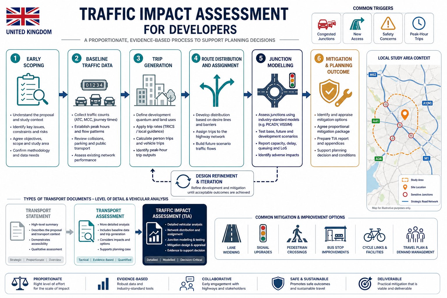
The Core Stages Of A Traffic Impact Assessment
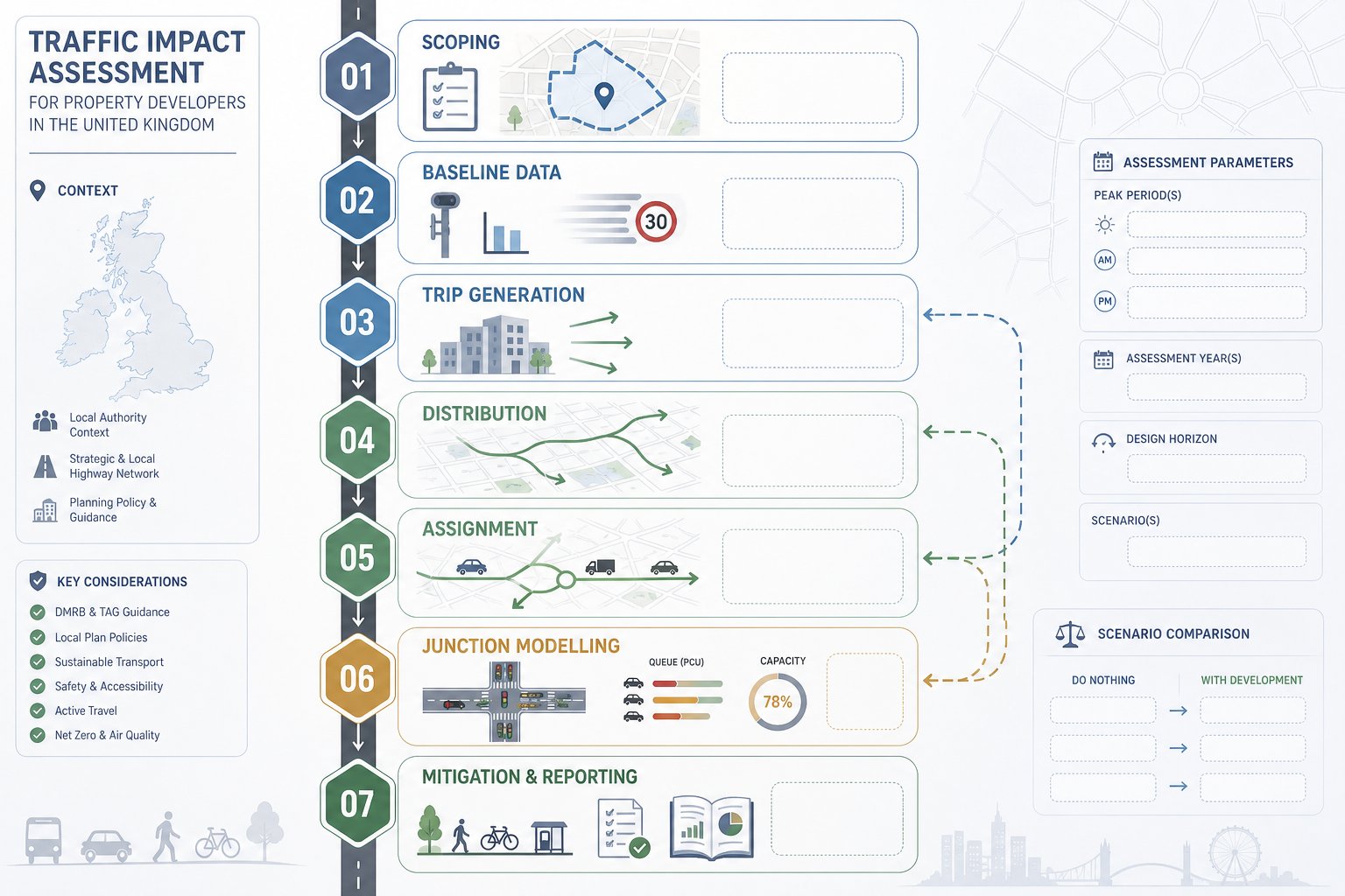
A well-prepared TIA follows a fairly consistent sequence, even though the detail varies by site and authority. Understanding that sequence helps developers programme surveys, design work, and planning submissions more sensibly.
The process usually begins with scope, then moves through baseline evidence, trip forecasting, routeing, network testing, and mitigation. If any of those stages are rushed, problems tend to appear later, often when revisions are more expensive.
We also find that the best assessments are iterative rather than linear. The modelling might reveal that an access arrangement needs refinement. A revised layout may alter internal circulation or servicing. A mitigation option may improve a junction enough to support a later phase. So while the stages are technical, they’re also design tools.
For teams handling multiple planning inputs at once, this is where experienced transport consultants earn their fee: not by producing a long report, but by making each stage answer a development question before it becomes a planning objection.
Scoping, Baseline Data, Trip Generation, Distribution, Assignment, And Junction Modelling
Scoping comes first. We agree the study area, peak periods, future assessment years, development scenarios, committed developments to include, and the software or calculation methods likely to be accepted by the authority.
Baseline data comes next. That may include classified turning counts, queue lengths, journey times, speed surveys, collision analysis, parking stress, and observations of pedestrian and cycle movement. Existing conditions matter, but so do committed schemes that will change the network before the development opens.
Trip generation estimates how many journeys the proposal is likely to create, often using accepted databases, survey comparators, and professional judgement. For mixed-use schemes, this can get nuanced quite quickly.
Distribution and assignment then tests where those trips come from and where they go. A poor assignment pattern can undermine an otherwise competent report.
Finally, junction modelling assesses how the network performs in different scenarios: base year, future year without the scheme, and future year with it. This is where capacity issues, queueing effects, and mitigation needs usually become most visible. The output is then pulled into a report that explains impacts in plain planning terms, not just technical tables.
What Developers Need To Provide At The Start Of The Process
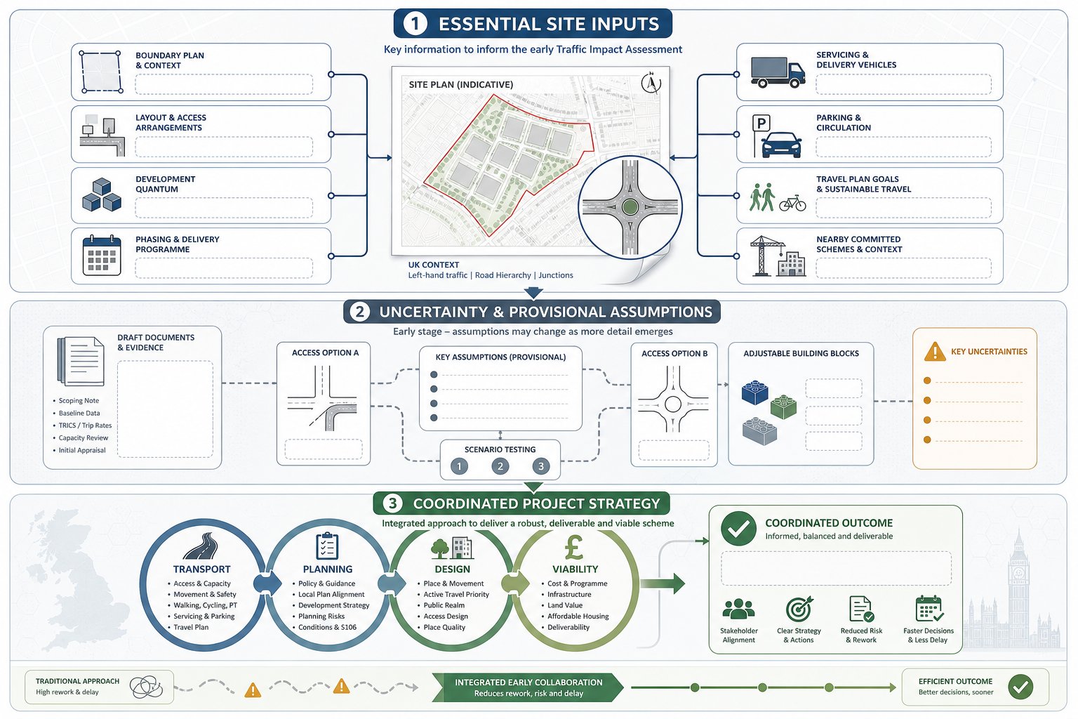
The quality of a TIA is heavily influenced by what the developer team provides in the first week or two. If key information arrives late, transport work becomes reactive, and that often means duplicated modelling, revised figures, or avoidable delays.
At the outset, we generally need:
- the red-line boundary and any wider land control plan
- a draft site layout and access strategy
- the development quantum by land use, such as dwellings, gross floor area, pupils, beds, or seats
- proposed phasing and likely opening years
- expected servicing arrangements and vehicle types
- parking provision and internal circulation assumptions
- any travel plan ambitions or mode-share targets
- details of nearby committed or related schemes
Even rough information is better than silence, provided everyone understands what is provisional. The key is to flag uncertainty early. If the residential mix may change, if the commercial floorspace is only indicative, or if a signalised access is being considered alongside a priority option, that should be stated upfront.
This early briefing stage is also where broader traffic impact assessment developers strategy pays off. When transport assumptions align with planning, design, and viability from the beginning, the TIA becomes part of project coordination rather than a late technical hurdle.
Common Issues That Delay Approval Or Trigger Objections
Highways objections are often presented as if they arise from deep technical disputes. Sometimes they do. But more often, the root cause is procedural: the wrong scope, the wrong data, or the wrong assumptions.
One common issue is no early scoping with the authority. If the applicant team proceeds on its own view of the study area or survey hours and gets that wrong, the authority may ask for fresh analysis after submission. That can add weeks.
Another is out-of-date or thin baseline data. Traffic conditions change. Nearby schemes get built. Signal timings are revised. What looked acceptable six months ago can become questionable if the evidence is stale.
A third problem is underestimating trip rates or smoothing awkward peaks. Authorities are quick to challenge selective comparisons, optimistic reductions, or weak assumptions around linked trips and pass-by traffic, especially for retail and roadside uses.
Then there’s ignoring committed development. A junction may appear to cope until approved housing, employment, or education growth is added to the model.
And finally, we regularly see mitigation that isn’t deliverable. If proposed works sit outside highway control, lack land, rely on uncertain third-party consent, or are not proportionate to the impact, they can weaken rather than strengthen an application.
In practice, the fastest route to approval is not trying to make impacts disappear. It’s identifying them honestly, testing them properly, and resolving them before submission where possible.
Mitigation Measures That Can Strengthen A Development Proposal
Mitigation should do one thing above all: address the actual transport effect of the development in a way that is proportionate, deliverable, and understandable to decision-makers. Not every scheme needs major highway works. Some need none. But where impacts are identified, vague promises rarely satisfy anyone.
Common mitigation measures include:
- junction geometry changes, such as flare extensions or lane widening
- signal optimisation or signal-controlled junction upgrades
- revised site access arrangements and visibility improvements
- right-turn lanes, ghost islands, or splitter islands
- speed management, crossing facilities, and local safety measures
- improved footways, cycle links, and bus stop infrastructure
- travel plans and demand management measures to reduce single-occupancy car trips
- delivery and servicing controls
- construction traffic management plans
The strongest mitigation packages are usually layered. A residential scheme might pair a junction improvement with pedestrian crossing upgrades and a travel plan. A school may need pick-up/drop-off management, walking routes, and timed operational controls. A logistics or industrial site could depend heavily on swept-path design, routing arrangements, and peak management.
Authorities also tend to respond better when mitigation is tied to evidence rather than offered as a generic wish list. If the TIA shows a specific arm of a roundabout deteriorating beyond acceptable operation, the solution should address that precise issue. Good mitigation feels engineered, not improvised.
How A Strong TIA Supports Planning, Design, And Delivery Decisions
A strong TIA doesn’t just help us get through validation or answer a consultee response. It improves the scheme itself.
At planning stage, it gives the applicant team a credible evidence base. That can support statements of case, committee reports, negotiations over conditions, and, where needed, appeal submissions. It also helps explain why certain design choices were made, which is valuable when objections focus on traffic, safety, or local congestion fears.
At design stage, a TIA often influences access location, internal road hierarchy, parking layout, servicing space, and phasing. Sometimes a modest layout tweak avoids an expensive off-site junction upgrade. Sometimes the analysis confirms that a proposed access is too close to a constrained node and should move before drawings are fixed.
At delivery stage, transport evidence can shape section 106 and section 278 discussions, trigger points for works, and the timing of occupation relative to mitigation delivery. It also gives project managers something solid to work from when contractors, legal teams, and highways officers need the same answer to the same question.
That’s especially true on sensitive or urban sites, where concise local knowledge matters as much as modelling. We often see better outcomes when transport input is treated as part of place-making and delivery planning, not a separate technical appendix.
Choosing The Right Time To Commission A TIA
The best time to commission a TIA is almost always earlier than the team first thinks.
In most cases, that means the concept or early planning design stage, before the layout is fixed and well before submission. At that point, transport evidence can still influence access design, land take, parking strategy, servicing, and phasing. Leave it too late and the TIA becomes a test of a nearly finished scheme rather than a tool for shaping one.
Early instruction also matters because transport work has lead-in time. Surveys must be commissioned, school holidays and abnormal periods avoided, baseline data reviewed, committed development tracked, and authority scope discussions allowed to happen. Then comes modelling, internal review, design coordination, and reporting. None of that is impossible under pressure, but compressed programmes tend to generate avoidable risk.
For complex sites, we usually suggest commissioning once there is a workable site plan, a broad development quantum, and a realistic planning route. That is enough to scope properly without waiting for every design detail. In some cases, especially where local junction sensitivity is obvious, an initial feasibility review can start even earlier. That kind of front-loaded thinking is often what keeps planning on track rather than trying to rescue it later.
Conclusion
For developers, a Traffic Impact Assessment is rarely just a planning document. It is a decision-making tool that tests whether a scheme can work on the network around it, what needs to change if it can’t, and how transport evidence should support the wider application.
The practical takeaway is simple enough: scope early, use current data, be realistic about trip generation, and make sure mitigation is directly tied to the impacts identified. When a TIA is commissioned at the right stage, it can guide layout, strengthen negotiations with authorities, and reduce the risk of avoidable delay.
In 2026, that matters more than ever. Authorities expect transport submissions to be proportionate, transparent, and technically robust. Developers who treat the TIA as an early project input rather than a late compliance exercise usually put themselves in a much stronger planning position.
Frequently Asked Questions About Traffic Impact Assessment for Developers
What is a Traffic Impact Assessment and why is it important for developers?
A Traffic Impact Assessment (TIA) is a detailed study evaluating how a proposed development will affect nearby roads and junctions. It helps developers understand if the local network can handle additional traffic safely, informs access design, identifies required mitigation, and reduces risks of refusal or costly redesign.
How does a Traffic Impact Assessment differ from a Transport Statement or Transport Assessment?
A Transport Statement is a brief overview suitable for small developments with limited impact. A Transport Assessment covers wider transport modes like walking and public transit. A Traffic Impact Assessment specifically focuses on vehicular traffic effects, involving detailed capacity and junction modelling usually for larger or complex projects.
When is a Traffic Impact Assessment typically required for a planning application?
A TIA is usually required when development is expected to generate around 100 or more two-way peak-hour vehicle trips, or when there are sensitive network conditions, altered access points, or local highway safety concerns. Local authorities provide specific guidance, so early scoping is recommended.
What information should developers provide when commissioning a Traffic Impact Assessment?
Developers should provide the red-line boundary, draft site layout, access strategy, quantum of development by land use, proposed phasing and opening years, servicing plans, parking layout, any travel plan targets, and details of nearby committed developments to ensure accurate and timely assessment.
What common issues cause delays or objections in Traffic Impact Assessment approvals?
Delays often stem from lack of early scoping with authorities, outdated or insufficient traffic data, underestimated trip rates, ignoring committed developments, inadequate junction modelling, and mitigation proposals that are undeliverable or unrelated to actual impacts.
How can mitigation measures improve the chances of development approval in a Traffic Impact Assessment?
Effective mitigation addresses identified impacts directly with deliverable solutions such as junction improvements, access changes, safety enhancements, and travel demand management. Clear, evidence-based mitigation tied to specific issues strengthens planning applications and helps meet local authority expectations.