In Bradford, planning approval rarely turns on architecture alone. A scheme can look commercially sound, policy-led and perfectly viable on paper, yet still stall if the transport case is weak. That’s especially true in 2026, when highway impacts, active travel, public transport connectivity, servicing, air quality and carbon all carry more weight than they did a few years ago.
For developers, architects, planners and legal teams, transport planning Bradford requirements are no longer a box-ticking exercise. They’re often central to whether a site can be unlocked, whether conditions stay proportionate, and whether a proposal moves smoothly through consultation with Bradford Council Highways and wider West Yorkshire stakeholders.
We see this most often at the points where good projects become difficult: an access that hasn’t been tested properly, parking that doesn’t reflect the location, a town-centre scheme with no clear servicing plan, or a Transport Assessment that misses the junction everyone in the room is worried about. None of those issues are unusual. But they are avoidable.
In this guide, we set out what developers need to know about transport planning in Bradford in 2026: when evidence is likely to be required, which reports matter, the local issues that often influence decisions, and how to prepare a submission that stands up technically and reads well to officers, consultees and committees alike.
Why Transport Planning Matters For Bradford Development Projects
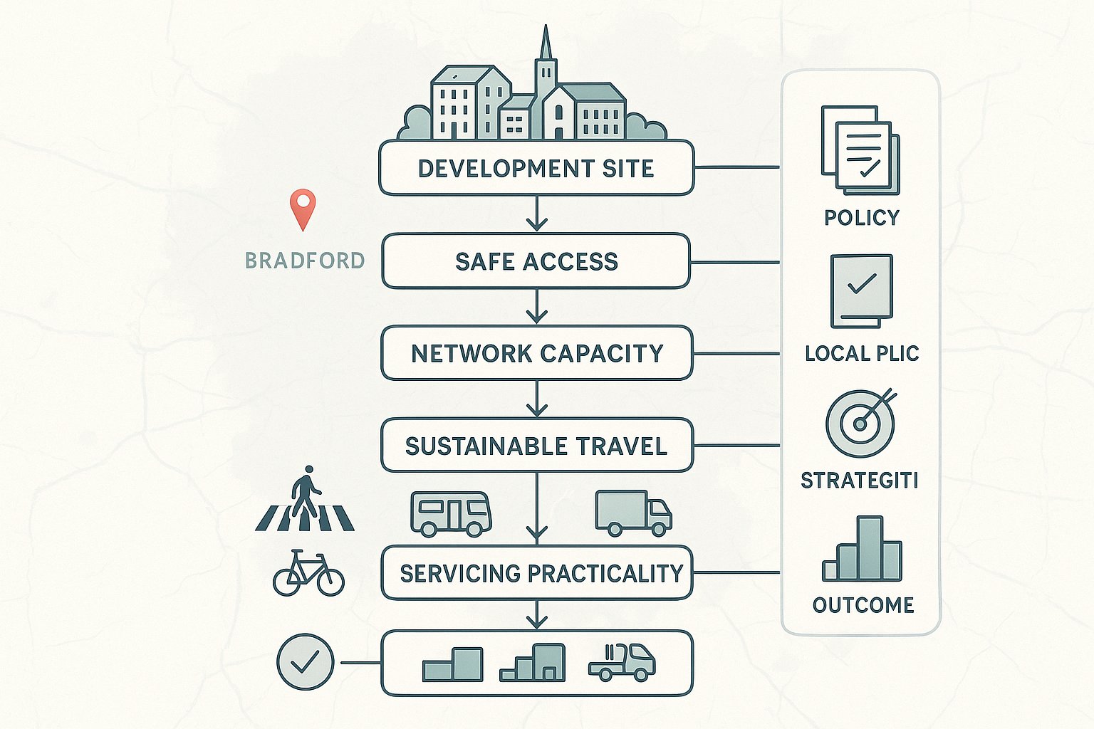
Transport planning matters because it does more than measure vehicle movements. At its best, it shows that a development can function safely, connect properly to its surroundings, and avoid creating impacts that decision-makers would regard as severe.
In Bradford, that matters across a wide range of schemes: housing, retail, industrial, education, healthcare and mixed-use regeneration. The city centre, district centres and growth corridors all have different transport characteristics, but the same core questions tend to arise. Can people get to the site safely? Will the local highway network cope? Does the proposal support walking, cycling and public transport in a credible way? And is servicing practical without spilling problems onto surrounding streets?
Those questions tie directly into planning policy. National policy expects safe and suitable access for all users and resists development only where transport impacts would be severe. Local policy and West Yorkshire transport strategies then add another layer, particularly around regeneration, integrated movement networks, accessibility and emissions reduction.
For developers, strong transport planning can unlock a site early. It can identify whether an access is realistic, whether junction mitigation is likely, whether parking will be contentious, and whether a phased strategy is needed. For us, that’s the real value: not producing a report for its own sake, but reducing planning risk before a project has gone too far down the line.
When A Bradford Scheme Is Likely To Need Transport Evidence
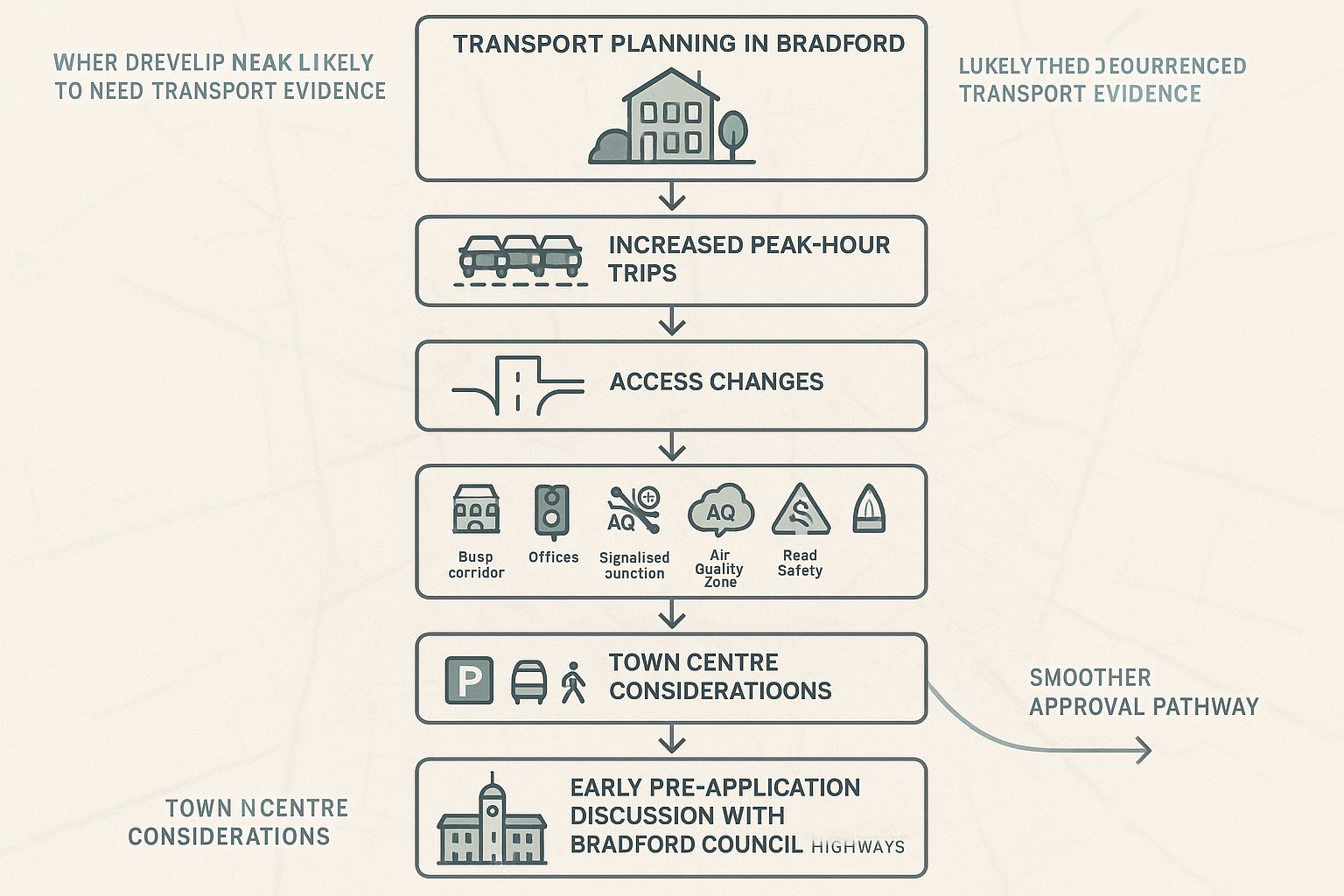
Not every proposal needs a full technical package, but many more schemes need transport evidence than applicants first assume.
In Bradford, a scheme is likely to need transport input where it generates noticeable additional trips, particularly in the peak hours. As a rule of thumb, once a development starts creating around 30 to 50 extra peak-hour movements, officers will usually expect at least a proportionate review. That doesn’t mean every project above that threshold needs an exhaustive Transport Assessment, but it does mean transport planning should be considered early.
Evidence is also commonly needed where a proposal introduces a new access, alters an existing access, changes turning movements, or relies on constrained frontage conditions. Even relatively modest developments can attract detailed highways scrutiny if the site sits on a busy corridor, near a sensitive junction, within or close to an Air Quality Management Area, or in a location with a known road safety record.
Larger housing schemes, employment sites, retail development, schools, healthcare facilities and mixed-use proposals almost always need supporting transport documentation. Town-centre projects may also need focused evidence around parking restraint, public transport accessibility and servicing.
In practice, pre-application engagement with Bradford Council Highways is often the point where scope becomes clearer. If that conversation happens early, the application usually moves faster.
The Main Transport Planning Reports Used In Bradford Applications
Bradford planning applications can involve several transport documents, and each serves a different purpose. Choosing the right mix matters. Too little evidence creates avoidable objections. Too much, oddly enough, can bury the key points.
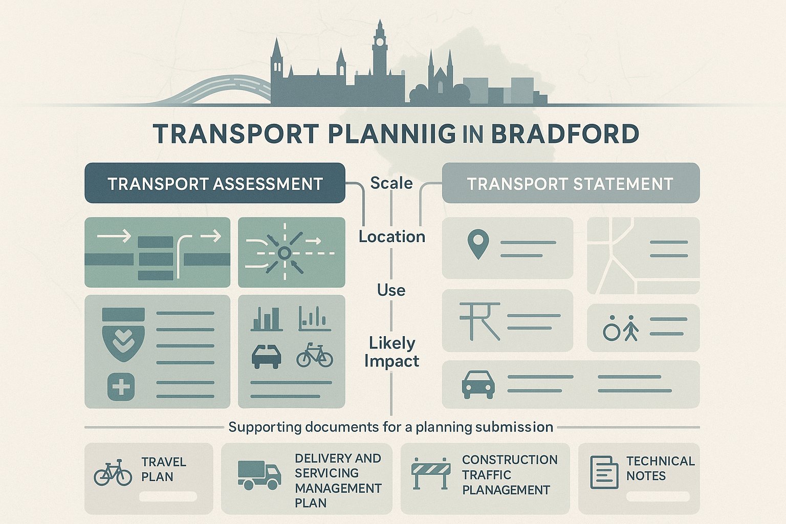
The most common reports are a Transport Assessment (TA), Transport Statement (TS), Travel Plan, Delivery and Servicing Management Plan, Construction Traffic Management Plan, and shorter technical notes covering specific issues such as junction modelling, swept path analysis, parking review or revised trip rates.
The right package depends on scale, use, location and likely impact. A residential scheme on a quiet suburban site may need a straightforward TS with access drawings and a Travel Plan. A city-centre mixed-use scheme might need a TA, public transport accessibility review, servicing strategy and targeted modelling. An industrial or logistics proposal may turn heavily on HGV routing, turning and yard operation rather than commuter traffic alone.
What Bradford officers and consultees usually want is proportionate, reliable evidence. They need to understand what the proposal does, how people and vehicles will reach it, what the surrounding network conditions are, and whether practical mitigation is available. When those points are clear, determination tends to be more straightforward.
Transport Assessment Vs Transport Statement
A Transport Assessment is the more detailed document and is typically used for larger or higher-impact schemes. It normally includes traffic surveys, trip generation, trip distribution and assignment, junction capacity testing, road safety review, sustainable travel analysis and a package of mitigation where needed. It is the report used when the scale of impact could materially influence planning judgement.
A Transport Statement is lighter-touch and intended for smaller developments with limited transport effects. It still needs to be competent and evidence-based, but the emphasis is on proportionality. A TS may explain existing site conditions, review accessibility, assess access arrangements, estimate trips at a simpler level and confirm why wider modelling is unnecessary.
The mistake we sometimes see is treating a TS as an informal note. It isn’t. If a scheme’s effects are genuinely modest, a TS can work very well. But if the development is likely to affect a sensitive junction or create a contested access issue, a full TA is usually the safer route.
Travel Plans, Delivery Plans, And Supporting Technical Notes
A Travel Plan explains how the development will encourage sustainable travel. For residential schemes, that might include welcome packs, cycle storage, public transport information and monitoring. For workplaces, it may extend to shower facilities, car-share measures, travel coordinators and targets for reducing single-occupancy car trips.
A Delivery and Servicing Management Plan becomes important where servicing could disrupt nearby streets, especially in town centres or constrained urban locations. It can cover delivery hours, vehicle types, loading locations, routing and management arrangements.
Supporting technical notes are often used to answer specific comments or refine an evolving design. For example, we may issue a note on revised junction modelling, updated traffic counts, parking accumulation, refuse vehicle tracking or emergency access. These shorter documents can be very effective because they deal directly with the officer concern rather than forcing everyone back through a full report.
Key Bradford Transport Issues That Can Affect Planning Decisions
Some transport issues appear again and again in Bradford applications, and they’re worth addressing head-on.
The first is junction capacity and corridor congestion. Bradford has several busy radial routes, constrained urban links and pressure points around town centres, schools and employment areas. If a scheme adds traffic to a location already known for queueing and delay, officers are likely to ask detailed questions about baseline conditions, committed development and the realism of mitigation.
The second is road safety, especially where vulnerable users are involved. That includes pedestrian crossing opportunities, visibility at accesses, cycle conflicts, turning movements near schools, and collision history on the surrounding network. A proposal can be modest in traffic terms yet still struggle if the access design is poor.
Third, public transport and active travel connectivity carry real weight. Bradford is pushing regeneration alongside better bus, rail, walking and cycling integration across West Yorkshire. A site that relies almost entirely on the private car will face harder questions than one that can demonstrate practical links to bus stops, rail stations, footways and cycle routes.
Then there’s air quality and carbon. In some locations, especially on more heavily trafficked corridors, decision-makers will want confidence that the proposal does not worsen local conditions without mitigation.
In short, transport planning Bradford decisions often turn less on one dramatic flaw and more on whether these linked issues have been handled with enough realism.
Access, Parking, And Servicing Expectations For Different Site Types
Different uses attract different transport expectations, and a one-size-fits-all approach usually causes trouble.
For residential schemes, the basics still matter: safe vehicular access, convenient pedestrian routes, suitable visibility splays, refuse and emergency vehicle access, cycle parking and parking provision that reflects the site’s context. In more accessible locations, especially near centres and corridors with good bus links, excessive parking can be questioned just as much as under-provision. EV charging is now part of the discussion almost by default.
For town-centre development, expectations shift. Car parking is often lower, and the supporting case needs to lean more heavily on walkability, bus and rail access, and a workable servicing strategy. Officers will want to know how deliveries happen, where loading takes place, and whether taxis, drop-offs or short-stay activity will obstruct already busy streets.
For employment, industrial and warehousing sites, HGV movement becomes central. Routing, access geometry, internal turning, yard depth, loading arrangements and the relationship with neighbouring land uses all need careful thought. A site can meet parking standards on paper yet still be operationally weak if HGVs have to reverse awkwardly or wait on the highway.
Across all site types, drawings and reports must tell the same story. If the swept paths, parking schedules and written assumptions don’t align, confidence drops quickly.
How Local Policy And Highway Authority Requirements Shape Submissions
A good transport submission for Bradford isn’t built on generic national wording. It needs to reflect the local policy and highway context.
The starting point is the Bradford Local Plan and related guidance, alongside national policy and design principles. Those local documents shape expectations on access quality, parking, layout, placemaking and the relationship between development and the wider movement network. They also influence how much weight is given to public transport accessibility, active travel connections and regeneration aims.
Highways requirements are then filtered through Bradford Council’s own standards and design expectations, often informed by highway design guidance on matters such as visibility, geometry, adoptability, parking layout and service access. Depending on the proposal, West Yorkshire Combined Authority (WYCA) may also be relevant, particularly where bus movement, corridor improvements, strategic transport interventions or active travel objectives are affected.
This matters because transport evidence is not judged in isolation. A technically competent access can still face resistance if it undermines a wider scheme for bus priority, prejudices a committed junction improvement, or ignores nearby walking and cycling proposals.
We’ve found that the strongest submissions do two things at once: they satisfy the detailed highway checks, and they show how the development fits the direction of travel for Bradford and West Yorkshire more broadly. That can make the difference between a defensive report and a persuasive one.
The Transport Planning Process From Feasibility To Planning Decision
The transport process works best when it starts before the application is drafted. By the time a red line boundary is fixed and the layout is politically sensitive, options are already narrowing.
A typical Bradford process begins with a feasibility review of the site, surrounding network, policy position and likely evidence needs. From there, the key task is agreeing scope: what level of report is required, which junctions need review, which survey periods are appropriate, and what assessment years should be tested. Once that is settled, survey work, trip forecasting, access design and mitigation can proceed on a sensible basis.
After submission, the process doesn’t stop. Highways officers may ask for clarifications, updated figures, further sensitivity testing or a more explicit mitigation commitment. Developers who plan for that stage, rather than seeing submission as the finish line, usually manage the programme better.
Early Site Appraisal And Pre-Application Advice
Early appraisal is where we can save the most time and cost. At this stage, we review the highway context, nearby junctions, collision history, public transport accessibility, walk and cycle links, parking constraints, servicing practicality and any obvious policy risks.
For a developer, this is often the moment when a site’s hidden transport issues become visible. A frontage may look generous until tracked refuse movements are tested. A route may appear sustainable until the nearest usable crossing is found to be several minutes away on an unpleasant road. Or a seemingly simple intensification may sit beside a junction already operating close to capacity.
Pre-application discussion with Bradford Council Highways is usually worthwhile, particularly for anything beyond a minor scheme. It helps establish whether a TA or TS is appropriate, which locations need modelling, what baseline year should be used, and whether there are local concerns around schools, bus operations, air quality or committed schemes.
Getting that scope agreed in writing is one of the simplest ways to reduce later delay.
Survey Work, Forecasting, And Junction Assessment
Once scope is clear, evidence gathering begins. That generally includes traffic counts, queue observations, site access surveys, parking beat surveys where relevant, personal injury collision review and accessibility mapping. Data needs to be recent and representative. Old counts are one of the quickest ways to trigger challenge.
Trip generation is then forecast using recognised sources such as TRICS, with sensible adjustments for location, use class and internalisation where justified. The next step is distribution and assignment: understanding where trips are likely to come from and go to, and which parts of the network matter most.
Where capacity is an issue, standard junction modelling tools may be used, such as PICADY, ARCADY or LinSig, depending on the junction type. The point isn’t to drown the authority in software output. It’s to test the real questions: does the network operate acceptably, are impacts material, and what mitigation would make the proposal workable?
Done properly, this stage gives the application a technical backbone rather than just a hopeful narrative.
Common Reasons Transport Planning Submissions In Bradford Are Delayed
Most delayed submissions are not delayed because transport is unusually complex. They are delayed because relatively ordinary issues were left unresolved.
A common problem is limited pre-application engagement. If the applicant has not discussed scope with Bradford Council Highways, the authority may come back asking for extra junctions, updated surveys or a different assessment approach after submission. That can add weeks quickly.
Another frequent issue is a report that does not follow the agreed scope or omits obvious local factors such as committed development, nearby highway changes or school-related peak conditions. Officers tend to notice those gaps immediately.
We also see delays caused by outdated or weak data. Traffic counts that are too old, surveys taken in unrepresentative conditions, or unsupported assumptions on mode share can undermine an otherwise solid submission. The same goes for insufficient junction modelling where a known pressure point has been left untested.
Then there are the avoidable presentation issues: inconsistent trip numbers between drawings and text, parking figures that don’t match the layout, mitigation described vaguely with no delivery route, or a Travel Plan that reads as boilerplate.
None of that is dramatic. But in planning, small inconsistencies have a habit of becoming large objections.
How To Prepare A Stronger Transport Planning Submission In Bradford
The strongest submissions are usually not the longest. They are the clearest, best-scoped and easiest to trust.
First, engage early with Bradford Council Highways and, where relevant, wider West Yorkshire stakeholders. That early conversation helps define what level of evidence is actually needed and avoids spending time on the wrong issues.
Second, agree the scope and methodology in writing. If the study area, peak periods, junctions, forecast years and assessment approach are set out clearly from the start, later debate becomes narrower and more manageable.
Third, use robust and current data. Recent surveys, transparent TRICS analysis and recognised modelling tools matter. So does professional judgement. Authorities are generally receptive to proportionate assessments, but they are less forgiving of unsupported assumptions.
Fourth, make the submission readable. A concise non-technical summary, clear figures, legible plans and direct explanations of mitigation all help. Officers and consultees should not have to work hard to find the answer.
Finally, link the scheme to Bradford’s wider objectives. Show not only that impacts are acceptable, but that the development supports safer access, realistic travel choice, regeneration and climate goals.
That’s the approach we favour at ML Traffic: concise, accurate transport engineering reports, delivered quickly, and tailored to local authority thresholds and planning context. In Bradford, that combination tends to give projects the best chance of a smoother route to approval.
Strong transport planning doesn’t guarantee consent, of course. But weak transport planning can derail an otherwise good scheme. In 2026, that gap matters more than ever.
For developers, the practical takeaway is simple: start early, scope properly, test the right issues, and present the evidence in a way that is both technically sound and easy to follow. When we do that well, transport stops being a late-stage obstacle and becomes part of how a site is successfully unlocked.
Transport Planning in Bradford: Frequently Asked Questions
What is the importance of transport planning for development projects in Bradford?
Transport planning in Bradford ensures developments provide safe access, manage congestion, support active travel and public transport, and comply with local and national policies to avoid severe transport impacts, thereby helping to unlock sites and support regeneration.
When is transport evidence required for a Bradford planning application?
Transport evidence is typically needed when a development generates around 30–50 or more peak-hour trips, introduces new or altered site access, involves large scale housing, retail, employment, education, or healthcare uses, or affects busy junctions and Air Quality Management Areas.
What is the difference between a Transport Assessment and a Transport Statement in Bradford?
A Transport Assessment is detailed, for larger or higher-impact developments including surveys, traffic modelling, and mitigation. A Transport Statement is a lighter, proportionate report for smaller schemes with limited transport impact, still requiring competent evidence but less complexity.
How does Bradford’s local policy influence transport planning submissions?
Bradford’s Local Plan, Supplementary Guidance, and Highway Design Guide set standards on access, parking, visibility, and layout. Submissions must align with these and West Yorkshire transport strategies, ensuring developments support wider regeneration, active travel, public transport, and do not prejudice committed highway schemes.
What are common reasons for delays in transport planning submissions in Bradford?
Delays often arise from inadequate pre-application engagement, failures to follow agreed scope, missing committed development in assessments, outdated traffic data, insufficient junction modelling, unclear mitigation plans, and inconsistent data between reports and drawings.
How can developers prepare a stronger transport planning submission in Bradford?
Developers should engage early with Bradford Council Highways, agree scope and methodology in writing, use recent survey data and recognised modelling tools, provide clear non-technical summaries, and demonstrate how their proposals support local transport, climate, and regeneration objectives.