If you’re promoting a scheme in Liverpool in 2026, transport is rarely a box-ticking exercise. It can be the difference between a smooth planning determination and months of avoidable back-and-forth. We see it all the time: a strong design team, a viable site, solid planning arguments, then the application slows because the transport case wasn’t scoped early enough, the surveys were too thin, or the report didn’t quite reflect Liverpool’s local realities.
That matters even more now. Transport planning Liverpool projects sit within a city region shaped by regeneration, constrained highway corridors, busy pedestrian environments, major visitor activity, and a policy push toward public transport, walking and cycling. In practice, that means decision-makers want more than a simple vehicle access note. They want evidence that a development can work safely, sustainably, and without causing unacceptable impacts on the wider network.
For architects, planners, surveyors, developers, lawyers and local authorities, the real challenge is knowing what level of transport input is proportionate, and what Liverpool-specific issues are likely to be scrutinised. A city centre student scheme is not assessed like an edge-of-centre retail unit. A waterfront site is not the same as a suburban housing parcel. Context changes everything.
In this guide, we set out what developers need to know about transport planning in Liverpool, when a Transport Assessment or Transport Statement is likely to be required, what a robust report should include, and how to reduce the risk of delays on the route to approval.
Why Transport Planning Matters For Liverpool Developments
Transport planning matters because it answers a basic planning question: can a development be accessed safely and efficiently by the people who will use it, without creating unacceptable effects on the surrounding network?
In Liverpool, that question has extra weight. The city sits within the Liverpool City Region Combined Authority framework and the Merseyside Local Transport Plan context, with a clear policy direction toward mode shift, better public transport integration, healthier streets and lower car dependence. So when we prepare evidence for a scheme, we’re not just looking at traffic counts and turning movements. We’re also looking at how the proposal fits wider transport and regeneration objectives.
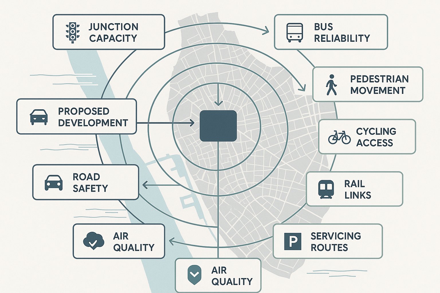
That has practical implications. A development can affect junction capacity, bus reliability, pedestrian comfort, servicing patterns, road safety, air quality and parking stress. On constrained approaches to the city centre, around major destinations, or near tunnel routes and waterfront corridors, even modest changes in demand can attract scrutiny.
Done properly, transport planning reduces uncertainty. It helps identify whether junction modelling is needed, whether access geometry works, whether parking levels are defensible, and whether a Travel Plan or mitigation package should accompany the application. It can also strengthen the planning narrative by showing how a site benefits from existing rail, bus, cycling and walking links.
In short, robust transport planning Liverpool applications need is about risk management as much as policy compliance. It gives the local planning authority and highway stakeholders confidence that the proposal has been tested properly, and that confidence often speeds decisions.
Liverpool Planning Context And Local Transport Considerations
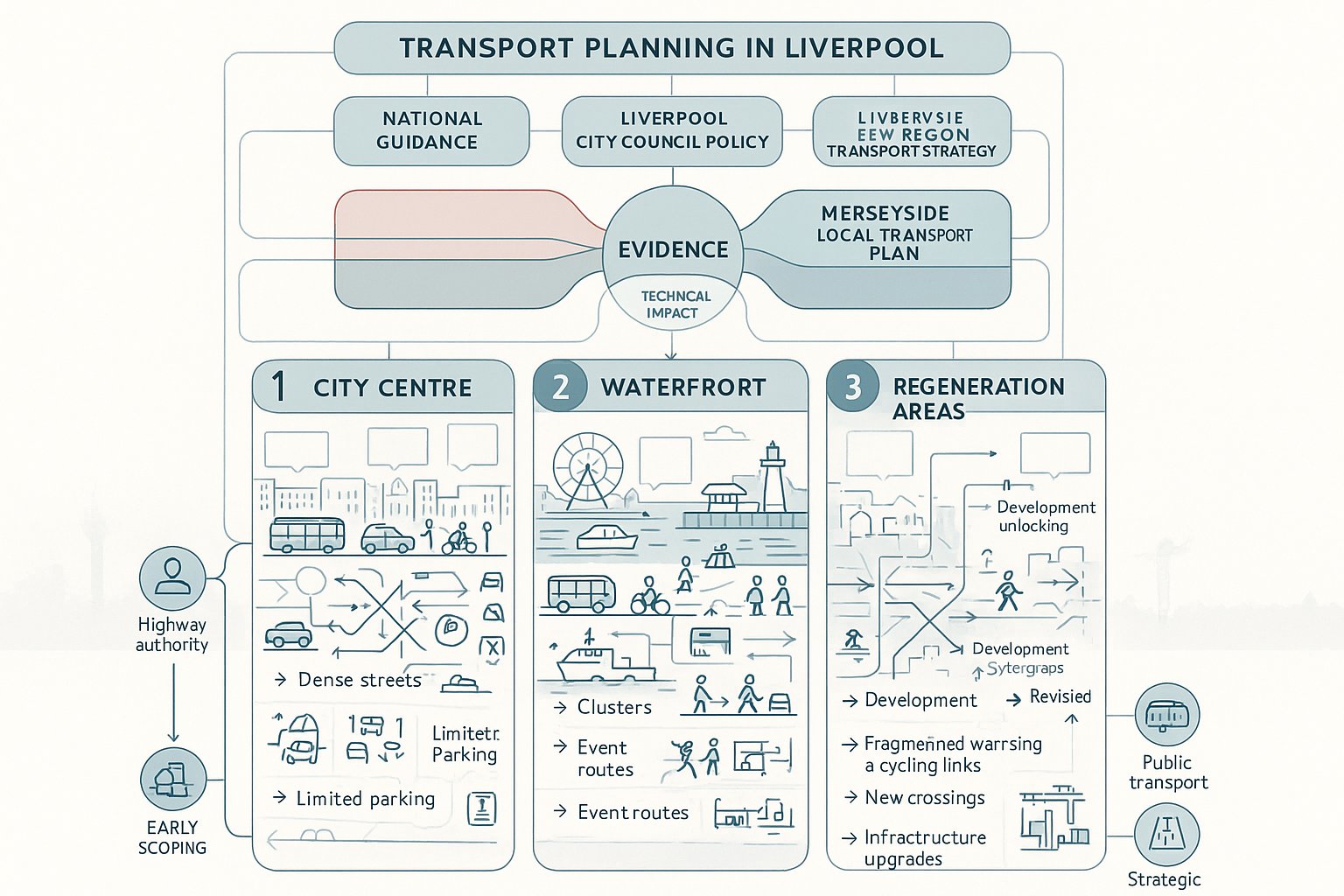
Liverpool developments are assessed against a layered planning and transport policy background. At the broadest level, there’s national planning and transport guidance. Locally, the key context includes Liverpool City Council planning policy, the Liverpool City Region Combined Authority transport agenda, and the Merseyside Local Transport Plan, with the emerging LTP4 continuing the emphasis on sustainable growth, connectivity and regeneration.
For applicants, that means transport evidence has to do two things at once. First, it must quantify impact in a technically robust way. Second, it must show policy alignment. A report that only focuses on vehicle movements, while saying little about walking, cycling, public transport access or wider place objectives, can feel incomplete in Liverpool’s current planning climate.
Local conditions also vary sharply from one part of the city to another. Some sites sit in dense mixed-use areas with strong non-car accessibility and limited appetite for additional parking. Others are in former industrial or regeneration locations where new infrastructure, improved crossings or revised servicing arrangements may be needed to unlock development.
We also need to be alert to the authority and stakeholder landscape. Depending on the site, comments may come from the local highway authority, combined authority transport teams, public transport interests, and in some cases National Highways where strategic routes are affected. That’s one reason early scoping matters so much: it helps us match the evidence to the real issues rather than guessing what will be asked for later.
How City Centre, Waterfront, And Regeneration Locations Affect Requirements
Location changes the entire transport story.
In the city centre, the focus is often less about raw parking provision and more about pedestrian movement, servicing hours, access management, taxi activity, bus operations, and interactions with a dense urban network. High footfall, constrained carriageways and nearby rail stations can support reduced car reliance, but they also create design and safety challenges that need careful treatment.
Waterfront sites bring another layer. They may be close to major visitor destinations, event routes, ferry connections or sensitive urban corridors where peak conditions fluctuate. The transport case may need to consider event-day traffic, coach activity, pedestrian surges and the quality of links back into the wider city centre.
Regeneration areas, former docklands, industrial estates, edge-of-centre opportunity sites, often require more enabling work. Existing street layouts may be poor, active travel routes fragmented, public transport access weaker, and baseline travel patterns less settled. Here, a transport planning report often needs to do more than assess impact: it needs to explain how the development can help structure future movement, support infrastructure upgrades and align with regeneration objectives.
That’s why template reporting rarely works. In Liverpool, the same land use can trigger very different requirements depending on where it sits and how the surrounding network operates.
When A Transport Assessment Or Transport Statement Is Needed
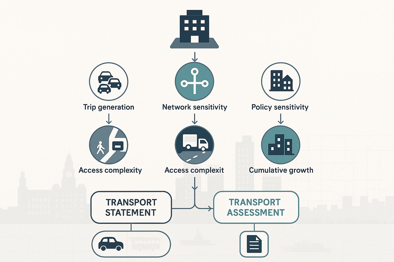
A Transport Assessment (TA) or Transport Statement (TS) is usually needed where a proposal is likely to generate a material amount of movement or where the site sits in a sensitive location. National guidance sets the overall direction, but local policy and authority expectations influence what is considered proportionate in practice.
As a rule of thumb, a TS suits smaller developments with limited transport effects, while a TA is appropriate for schemes with higher trip generation, more complex access issues, or potential network impacts that need deeper testing. In Liverpool, sensitivity of location can matter just as much as scale. A modest scheme on a constrained city centre street may justify more analysis than a larger proposal in a lower-pressure suburban context.
We normally advise clients to think about five early triggers:
- Trip generation: Will the development create a noticeable number of person trips or vehicle movements?
- Network sensitivity: Are there constrained junctions, event routes, schools, or major pedestrian flows nearby?
- Access complexity: Is a new access proposed, or does servicing create conflict?
- Policy sensitivity: Is the site in a location where sustainable travel measures will be closely tested?
- Cumulative growth: Are nearby schemes likely to compound impacts?
The safest route is early scoping with the relevant authority. That can confirm whether a TA, TS, Travel Plan, Delivery and Servicing Plan, Construction Traffic Management Plan or parking survey is expected. It also helps define survey extents, assessment years and modelling assumptions before the design is fixed.
Getting that call wrong can be expensive. Under-scoping often leads to late requests for more evidence, while over-scoping can waste time and budget. A good transport planning team finds the proportionate middle ground.
What A Liverpool Transport Planning Report Should Cover
A robust Liverpool transport planning report should be concise, evidence-led and tailored to the site, not a generic document with a local place name inserted at the top.
At minimum, we’d expect it to cover the planning and policy framework, the site context, baseline transport conditions, accessibility by all modes, proposed access arrangements, forecast trip generation, likely traffic distribution, and the development’s effect on the surrounding network. It should also explain parking, servicing, refuse collection, cycle provision, and any mitigation or Travel Plan measures.
Just as important is the narrative. Decision-makers need to understand why the level of analysis is proportionate, how assumptions were selected, and how the findings relate back to Liverpool’s policy priorities. If a site is highly accessible by rail and bus, that should feed through into mode share assumptions and parking strategy. If the area experiences heavy footfall or constrained servicing conditions, that should be addressed head-on.
A good report is auditable. Survey data should be current and clearly presented. Junction models should be explained, not dropped in without context. Drawings must align with the architectural and highways package. And recommendations should be realistic enough to be secured by condition or obligation if required.
In other words, the report should help officers and consultees say “yes” with confidence, not leave them with a list of unanswered questions.
Trip Generation, Distribution, And Junction Impact
This is where many applications either gain credibility or lose it.
Trip generation should be based on defensible evidence, typically using recognised databases and comparable local context. But numbers alone aren’t enough. In Liverpool, mode share assumptions need to reflect actual accessibility, site type and land use. A central student accommodation scheme beside major public transport links should not be assessed like an out-of-centre suburban development.
From there, trips need to be assigned logically across the network. We usually draw on observed turning patterns, local highway hierarchy, committed development data and known route choices. If the site sits near constrained corridors or busy junctions, distribution assumptions need particular care because small changes can alter the impact story.
Junction assessment should then focus on the locations that matter. That may involve priority junction assessments, signal modelling, capacity software or broader network review, depending on scale and sensitivity. The aim is not to model everything for the sake of it: it’s to show whether the development creates severe or unacceptable effects and whether mitigation is needed.
And mitigation doesn’t always mean major road works. Sometimes the answer is access refinement, signal timing changes, servicing controls, travel demand measures or a clearer pedestrian arrangement.
Sustainable Travel, Access, Servicing, And Parking
This part of the report often carries more weight than applicants expect.
Liverpool authorities are looking closely at how development supports walking, cycling and public transport use. So the report should explain pedestrian routes, crossing opportunities, cycle access, cycle parking quality, bus stop proximity, rail connectivity and any barriers to non-car travel. If improvements are needed, better footways, dropped crossings, wayfinding, or cycle links, they should be identified clearly.
Access arrangements must be safe and workable for all users. That includes visibility, swept paths, inclusive design, emergency access and day-to-day usability rather than just technical compliance on a plan.
Servicing deserves special attention, especially for city centre, student, hotel, retail, leisure and mixed-use schemes. If delivery vehicles will stop in the street, if refuse collection is constrained, or if servicing overlaps with pedestrian peaks, the authority will want reassurance. A Delivery and Servicing Plan can sometimes resolve concerns before they harden into objections.
Parking strategy also needs local realism. Too much parking can undermine policy and place objectives: too little, if unsupported by evidence, can trigger overspill concerns. A robust case explains why the proposed level is appropriate, how disabled parking is handled, where cycle parking sits, and how operational parking, pick-up/drop-off and car club measures fit the wider transport approach.
Common Development Types That Require Transport Planning Input
In Liverpool, transport planning input is needed across a wide range of development types, not just the obvious large-scale schemes.
Residential development often requires analysis of access design, parking, traffic generation, walking links, school-related effects and, for larger sites, internal street hierarchy and bus accessibility. Apartment schemes in accessible areas may also need a strong reduced-parking justification.
Student accommodation is a frequent feature of the Liverpool market and brings its own transport profile: lower car ownership, concentrated arrival/departure periods, servicing, taxi activity and high pedestrian movement.
Office, hotel, retail and leisure schemes can create time-specific peaks, servicing demands and interactions with city centre footfall or event patterns. The transport case needs to reflect actual operating characteristics, not generic land-use assumptions.
Education and healthcare developments often attract scrutiny because of pick-up/drop-off activity, vulnerable users, and peak overlap with existing network pressure.
Logistics, industrial and employment schemes may require more detailed access and swept-path work, HGV routing review, yard operation analysis and junction testing.
And then there are mixed-use regeneration schemes, which are often the most demanding. They combine multiple trip purposes, phased delivery, changing background traffic conditions and infrastructure dependencies. For these, transport planning becomes part of the masterplanning process rather than a report added at the end.
In our experience, developers benefit most when transport input starts as soon as site capacity and concept design are being tested. That’s when it adds value, not just paperwork.
Typical Issues That Delay Planning Applications
Most transport-related delays are avoidable. They usually happen because the evidence is incomplete, inconsistent or submitted too late to influence the scheme properly.
A common issue is weak baseline data. Traffic counts may be out of date, collected in school holidays, undertaken during abnormal network conditions, or too limited in extent. Parking stress surveys can also be poorly timed or too narrow to support the conclusions being made.
Another regular problem is underestimated trip generation. If assumptions look optimistic, consultees tend to lose confidence quickly and may ask for sensitivity testing or a full reassessment. The same goes for unconvincing distribution patterns that don’t match local route choice.
Then there’s insufficient junction analysis. Some reports identify likely pressure points but stop short of testing them properly. Others model junctions but ignore pedestrian effects, queue interaction or servicing conflict.
Design disconnects cause trouble too. We’ve seen transport reports describe one access arrangement while the planning drawings show another, or parking numbers change between submissions without the assessment being updated. That’s a guaranteed route to delay.
Other frequent sticking points include:
- non-compliant or poorly justified parking provision
- inadequate cycle parking or weak active travel links
- failure to address servicing and refuse collection properly
- no clear Travel Plan strategy where one is expected
- little reference to local policy, LTP priorities or regeneration context
For transport planning Liverpool schemes, the fastest approvals usually come from coordinated teams. When architects, planning consultants and transport advisers are working from the same assumptions early on, objections become far easier to avoid.
How Transport Planning Supports Planning Applications And Appeals
Transport planning supports planning applications by turning a broad claim, “this development works”, into a technical case that decision-makers can rely on.
At application stage, that means demonstrating policy compliance, showing that access is safe, quantifying likely movement, identifying any significant effects, and setting out mitigation where needed. Sometimes the value lies in proving impact is limited. In other cases, it lies in showing that a scheme with real impacts is still acceptable because those impacts are understood, managed and outweighed by wider benefits.
Good transport evidence also helps shape conditions and obligations. If mitigation is likely, it’s better to define it clearly than leave vague concerns hanging over the application. Travel Plans, junction improvements, footway works, servicing controls and monitoring measures can all help move an authority from concern to acceptance.
At appeal, the standard rises. Reports may be picked apart by opposing experts, so methodology, assumptions and policy references must stand up to scrutiny. A well-prepared TA or TS can become key evidence, especially where refusal reasons relate to highway safety, capacity, parking or sustainability.
This is where experience matters. Clear expert judgment, grounded in data, local knowledge and proportionate analysis, often carries more weight than a long report packed with unnecessary modelling. For clients using specialist consultants such as ML Traffic, the benefit is usually speed and clarity: evidence tailored to local thresholds and planning realities, rather than boilerplate analysis that invites challenge.
Working With Local Authorities And Highway Stakeholders
In Liverpool, early and practical engagement with stakeholders can save weeks, sometimes months.
The key bodies may include Liverpool City Council as local planning authority and highway authority functions, the Liverpool City Region Combined Authority in relation to broader transport strategy and public transport priorities, and National Highways where the strategic road network could be affected. Depending on the site, there may also be dialogue with public transport operators, regeneration teams or neighbouring authorities.
The point of engagement is not simply to “have a meeting”. It’s to agree the scope of work before positions harden. We want to know: is a Transport Statement enough, or is a full Transport Assessment expected? Which junctions need to be surveyed and modelled? What survey dates are acceptable? Is a Travel Plan required? Are there known local concerns around parking, servicing or pedestrian safety?
Those questions sound basic, but agreeing them early can prevent major redesign later.
It also helps to approach consultation with a realistic understanding of stakeholder priorities. Authorities are balancing development growth with network resilience, public realm quality, decarbonisation goals and political commitments around active travel and regeneration. If our evidence responds to those priorities rather than treating them as an afterthought, the conversation tends to be more constructive.
One final point: records matter. Scoping notes, meeting summaries and agreed methodologies create a clear audit trail. If personnel change during the application, that paper trail can be invaluable.
Preparing For A Smoother Application: Timing, Surveys, And Supporting Evidence
If we had to give one piece of advice, it would be this: start transport work earlier than you think you need to.
By the time an application is nearly ready, it’s often too late to commission ideal surveys, test alternative access options, or redesign a weak parking and servicing arrangement without affecting programme. Early transport input gives the team choices. Late input usually just reveals problems.
A smoother application generally starts with scoping. That means confirming the likely submission requirements, assessment years, study area, junctions, survey types and any local sensitivities. From there, we can commission the right evidence, which may include:
- traffic turning counts
- queue length observations
- parking accumulation and stress surveys
- pedestrian and cycle counts
- public transport accessibility review
- personal injury collision analysis
- servicing observations and swept-path checks
Supporting evidence should then be assembled into a coherent package. The transport report needs to align with the site layout, planning statement, Design and Access Statement, drainage and highways drawings, and any environmental material. If the scheme promotes sustainable travel benefits, those claims need to be visible in the design, not just written into the report.
For larger or more sensitive sites, we should also think ahead about mitigation deliverability. Can off-site works be implemented? Is there land control? Could a planning condition secure the details, or does the authority need more certainty at submission stage?
In 2026, the strongest Liverpool applications are usually those that connect transport evidence to wider place-making aims: regeneration, accessibility, public realm, and realistic travel behaviour. That’s what makes the package feel planning-led rather than purely technical.
Conclusion
Liverpool remains one of the UK’s most opportunity-rich development locations, but planning success depends on more than a good site and a workable scheme. Transport is often where technical confidence is won, or lost.
For developers, consultants and councils, the lesson is fairly simple: treat transport planning as an early strategy tool, not a late validation document. Scope the work properly. Use robust surveys. Respond to Liverpool’s city-centre pressures, regeneration priorities and sustainable travel expectations. And make sure the report speaks clearly to both policy and real-world operation.
When that happens, applications tend to move faster because fewer questions are left unanswered. And where schemes are more challenging, a well-built transport case can still create a credible route to approval or appeal success.
In a competitive 2026 planning environment, that’s the real value of good transport planning Liverpool projects need: fewer surprises, better evidence, and a smoother path through the system.
Transport Planning Liverpool: Frequently Asked Questions
Why is transport planning important for development projects in Liverpool?
Transport planning ensures developments can be accessed safely and efficiently across all travel modes, preventing unacceptable impacts on Liverpool’s constrained highways, busy pedestrian areas, and supporting city-wide regeneration and sustainable travel goals.
When is a Transport Assessment or Transport Statement required for Liverpool developments?
A Transport Assessment (TA) or Transport Statement (TS) is needed when a development generates significant traffic or is in a sensitive location. Smaller projects may require a TS, while larger or complex schemes with higher trip generation typically need a TA, following national guidance and local Liverpool transport policies.
How do city centre, waterfront, and regeneration site locations affect transport planning requirements in Liverpool?
Location alters transport needs: city centre sites focus on pedestrian movement and public transport integration; waterfront areas consider peak event traffic and visitor flows; regeneration sites often need infrastructure upgrades and sustainable travel strategies to unlock development potential.
What key elements should a comprehensive Liverpool transport planning report include?
A robust report covers policy frameworks, baseline transport conditions, trip generation and distribution, junction impact analysis, sustainable travel and access strategies, servicing and parking provisions, all tailored to Liverpool’s local context and aligned with city region objectives.
How can early engagement with Liverpool authorities benefit the transport planning process?
Early collaboration with Liverpool City Council, Liverpool City Region Combined Authority, and relevant stakeholders clarifies scope, survey needs, and mitigation measures, reducing delays and ensuring the transport evidence aligns with local priorities for a smoother planning approval process.
What common issues cause delays in transport planning approvals in Liverpool?
Delays often arise from outdated or insufficient survey data, underestimated trip generation, incomplete junction analysis, non-compliant parking strategies, weak sustainable travel links, and failure to address Liverpool’s Local Transport Plan policies effectively.