Planning consent in Derby rarely turns on architecture alone. A scheme can look right on paper, fit the site allocation, and still slow down because the transport case is thin, badly scoped, or out of step with local policy. We see this a lot: applications that could have moved more smoothly if transport planning had been dealt with earlier and with better local focus.
That matters even more in 2026. Derby City Council’s approach is shaped by its Local Transport Plan, wider growth ambitions, congestion pressures, road safety duties, and a clear expectation that new development should support walking, cycling and public transport rather than simply add car trips to an already constrained network. In a compact urban area, small technical gaps can become very visible.
For developers, architects, planners and land teams, good Transport Planning in Derby is not just a validation exercise. It is part evidence base, part risk management, and part negotiation tool. Done properly, it can show that access is safe, impacts are understood, mitigation is proportionate, and the proposal aligns with Derby’s transport priorities from the outset.
In this guide, we set out what usually triggers transport work, what Derby decision-makers tend to look for, where submissions commonly run into trouble, and how to prepare a stronger planning application first time.
Why Transport Planning Matters For Development In Derby
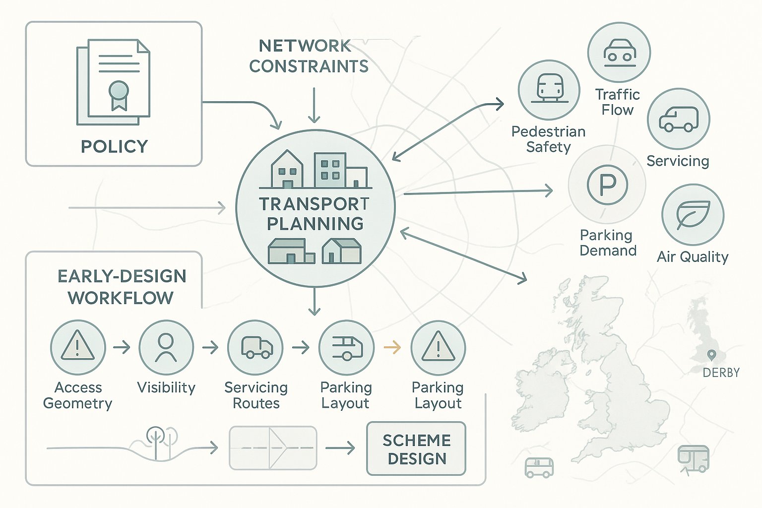
Transport planning matters in Derby because it sits at the point where growth meets real-world network constraints. The city needs housing, employment space, education facilities and regeneration. But every new scheme also affects traffic movement, pedestrian safety, servicing, parking demand, bus accessibility and, in some locations, air quality. Planning officers and highway consultees hence need evidence that development can function without creating unacceptable impacts.
Derby City Council’s Local Transport Plan 3 provides the policy backdrop. Although prepared for the 2011–2026 period, its core themes remain highly relevant to current applications: supporting economic growth, making best use of existing infrastructure, improving safety, and encouraging lower-carbon travel choices. In practice, that means a planning submission must do more than count vehicle trips. It must explain how a site connects into the wider transport system.
For applicants, transport planning also helps avoid expensive redesign. If access geometry is wrong, visibility is constrained, servicing conflicts with pedestrian routes, or parking is undercooked, those issues can derail a scheme surprisingly late. We prefer to treat transport evidence as an early design input, not a report to be commissioned once everything else is fixed.
That early-stage approach is especially useful in Derby, where local context can make a technically modest issue feel strategically important.
How Derby’s Local Transport Context Shapes Planning Decisions
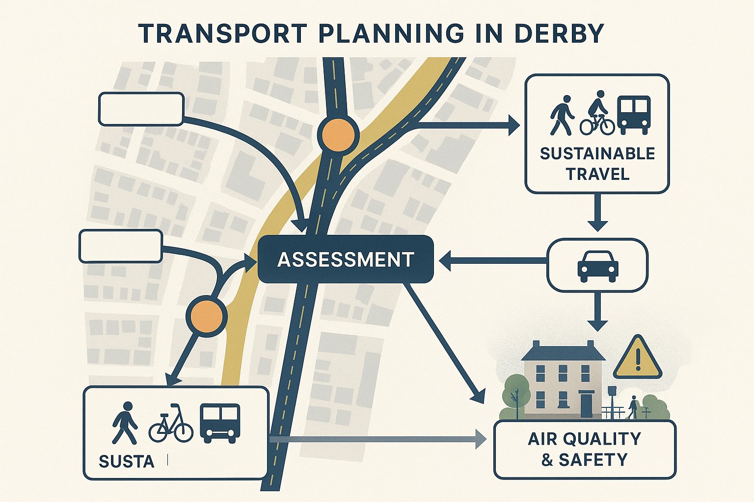
Derby’s planning decisions are shaped by a transport context that is quite specific: a compact urban area, established highway corridors, mixed-use neighbourhoods, and recurring pressure on key junctions and commuter routes. That combination means highway and transport comments often focus on cumulative impact rather than just the effect of one site in isolation.
Local policy places clear weight on reducing congestion and promoting sustainable travel. So if a proposal depends almost entirely on private car access, the supporting case needs to work harder. The question is not simply whether the junction still operates within capacity. It is whether people can realistically walk to nearby services, cycle safely, reach bus stops conveniently, and access the site without undermining Derby’s broader transport objectives.
Air quality can also shape the level of scrutiny, particularly on busier routes or where background conditions are already sensitive. Schemes close to constrained corridors may need more careful trip assumptions, stronger mitigation, or firmer Travel Plan measures. The same applies where there are known safety concerns, awkward frontage conditions or competing demands for kerbside space.
This is where local knowledge helps. At ML Traffic, we tend to find that Derby applications move more cleanly when the assessment is tailored to the authority’s likely concerns rather than lifted from a generic national template. That sounds obvious, but plenty of reports still miss the local nuance.
Common Development Types That Trigger Transport Planning Work
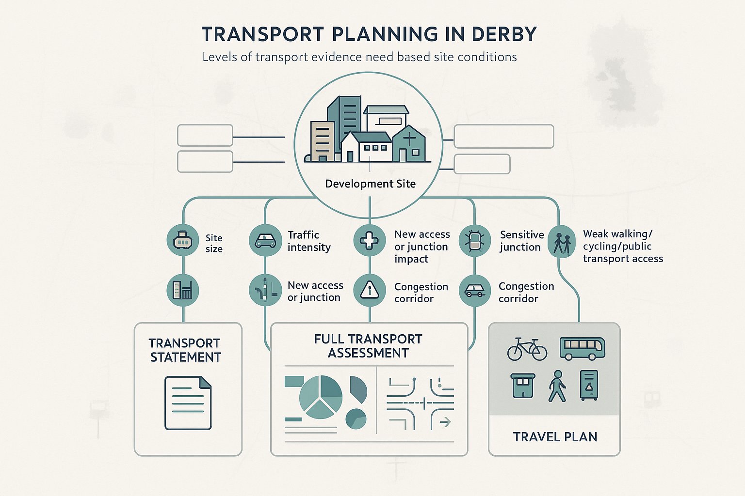
Not every planning application in Derby requires a full suite of transport documents, but many developments do trigger at least some form of transport evidence. Larger residential schemes are a common example, especially where new access points, internal roads, parking courts or off-site mitigation are involved. Employment developments, logistics sites, foodstores, drive-throughs, schools, healthcare uses and leisure schemes also tend to attract closer review because their trip profiles can be more intense or less predictable.
Mixed-use schemes deserve particular care. A proposal may appear balanced overall, yet the transport effects can vary sharply by time of day. A school near a busy commuter route, a care facility with shift patterns, or a town-centre leisure use with evening peaks all raise slightly different questions.
In Derby, trigger points are not purely about floor area. Location matters just as much. A relatively modest development on a constrained urban street, near a sensitive junction, or in an area where sustainable access is weak may need more supporting evidence than a larger scheme in a less problematic setting.
The main issue is proportionality. The right level of work depends on likely transport impacts, highway safety implications and policy sensitivity. That is why the first conversation is usually about whether the application needs a Transport Statement, a full Transport Assessment, a Travel Plan, or a combination of all three.
When A Transport Statement Is Appropriate
A Transport Statement is usually appropriate for small to medium developments where the transport effects are limited but still need to be demonstrated clearly. Think smaller housing sites, modest commercial changes, light industrial units, or redevelopments where traffic generation is not expected to rise sharply.
A good Transport Statement is not a cut-down document in the sloppy sense. It should still explain the local highway context, describe the proposed access arrangements, review collision history where relevant, and set out why the impact is likely to be acceptable. It may also cover parking provision, servicing arrangements, walking and cycling links, and the site’s accessibility to public transport.
In Derby, this level of assessment often works well where the proposal is straightforward and the surrounding network is not highly sensitive. But the analysis still needs to be credible. If the statement understates trip rates or skips a local issue that officers already know about, it can quickly lose weight.
When A Full Transport Assessment Is Needed
A full Transport Assessment is generally needed for major developments or for sites with material traffic, safety or network effects. Larger housing allocations, substantial employment schemes, retail parks, education campuses and healthcare facilities are typical candidates.
The threshold is not only size. A smaller application may also need a full assessment if it sits on a congested corridor, affects an Air Quality Management Area, relies on a difficult access, or could alter operation at a nearby junction. In those cases, Derby’s decision-makers will usually want more than a broad narrative. They will expect evidence on trip generation, distribution, assignment, baseline conditions, committed development, and likely junction performance with and without the scheme.
This is often where weak applications begin to wobble. If the modelling assumptions are not agreed early, or if peak periods are chosen badly, applicants can end up revisiting work after submission.
When A Travel Plan Supports The Application
A Travel Plan is often required for developments that generate a meaningful volume of regular trips and where behaviour change is realistically possible. Schools, major employment uses, hospitals, large residential schemes and some mixed-use developments are the obvious examples.
In Derby, the value of a Travel Plan is closely tied to LTP3’s emphasis on lower-carbon travel. The council is not simply looking for a paragraph saying residents or staff might cycle. It will usually expect practical measures: cycle parking, welcome packs, bus information, personalised travel advice, shower and locker facilities, car club provision where suitable, monitoring, targets and named responsibility for delivery.
A Travel Plan should feel grounded in the site, not copied from the last application. If bus frequencies are poor, say so and address it honestly. If walking links need upgrading, build that into the package. Realistic plans tend to be taken more seriously than glossy but generic ones.
The Core Elements Of A Transport Planning Assessment
A robust transport planning assessment normally starts with policy and context, then moves steadily from baseline evidence to forecast impact and mitigation. In Derby, that usually means aligning the report with national guidance while clearly responding to local transport priorities.
Most assessments will include a review of relevant policy, an overview of the surrounding highway and movement network, site accessibility by different modes, collision history, existing traffic conditions, and the characteristics of the proposed development. From there, the analysis turns to trip generation, trip distribution, assignment, and any junction or network modelling needed to understand impact.
But numbers are only part of the story. A strong report also explains design logic. Why has the access been placed where it has? How will delivery vehicles enter and leave? Can pedestrians cross safely? Is parking provision balanced, or is it likely to create overspill? How does the proposal support sustainable travel in a way that is practical for future users?
The better assessments in Derby are the ones where these strands connect. Policy, design, evidence and mitigation all point in the same direction. The weaker ones feel assembled in separate parts by different teams that barely spoke to each other.
Site Access, Visibility, And Highway Safety Considerations
Site access is usually the first thing people look at, and with good reason. If vehicles cannot enter and leave safely, or if pedestrians and cyclists are squeezed into an afterthought, the application will struggle. Derby’s highway reviewers will typically want to see that access points are appropriate for the road type, traffic speeds, likely turning movements and expected user mix.
Visibility splays matter, but they are only one piece of the puzzle. The wider questions are often more telling: are footways continuous, can cycles move safely across the access, is there enough stacking space within the site, and will larger vehicles overrun kerbs or block opposing traffic? On constrained urban sites, these details can make or break the design.
Where a new junction or altered access is proposed, swept path analysis and, in some cases, Road Safety Audit input may be needed. Existing collision records should also be considered in context rather than treated as a box-ticking exercise. A low collision history does not automatically mean a poor layout is acceptable.
Sustainable Travel, Parking, And Servicing Requirements
Derby’s transport policy context puts real emphasis on sustainable travel, so assessments should demonstrate how people can reach the development without defaulting to the car every time. That usually means mapping walking routes, identifying nearby cycle connections, reviewing bus accessibility, and explaining how the site layout supports those options in practice.
Parking is rarely just a numbers debate. Too little can lead to overspill and neighbour objection: too much can undermine sustainability goals and consume valuable land. The right solution depends on use class, location, accessibility and operational need. Residential parking often needs a different balance from office or education parking, and disabled parking, electric vehicle charging and secure cycle parking should not be tacked on at the end.
Servicing can be just as contentious. If refuse vehicles, delivery vans or articulated lorries cannot manoeuvre efficiently, the impacts spill onto the public highway very quickly. A clear servicing strategy, backed by tracking where needed, helps avoid late concerns from officers and technical consultees.
Scoping, Surveys, And Evidence Needed For Derby Planning Applications
Early scoping saves time. That is probably the single most useful lesson in transport planning, and it applies strongly in Derby. Before surveys are commissioned or modelling assumptions are fixed, it is worth agreeing the broad approach with the local authority where possible: study area, key junctions, survey dates, peak periods, committed developments, and the likely form of assessment.
Without that step, applicants can spend money gathering data that does not answer the right questions. We have all seen it happen. A consultant collects turning counts in neutral months when the council expected school-term conditions, or models the weekday AM peak when the real stress point is Saturday retail traffic. Technically competent work can still miss the mark.
Typical evidence for Derby planning applications may include:
- classified traffic counts and turning counts:
- queue length or journey time data:
- parking beat surveys:
- pedestrian and cycle observations:
- collision data review:
- accessibility audits for walking, cycling and public transport:
- swept path analysis:
- junction modelling: and
- a framework or full Travel Plan.
The scope should match the risk profile of the site. A straightforward infill scheme may need only targeted surveys and a concise statement. A strategic scheme may require more extensive baseline work and iterative discussion with officers. Either way, the evidence needs to be current, transparent and clearly tied to the application drawings. If the layout changes, the transport package usually needs to change with it.
Working With Derby City Council And Highway Stakeholders
Good transport planning in Derby is rarely produced in isolation. The strongest applications are usually those where the project team engages early with Derby City Council’s transport and highway officers and treats that dialogue as part of the design process, not as a hurdle to clear at the end.
Pre-application discussions can help confirm what level of assessment is needed, whether particular junctions should be tested, what survey information is likely to be acceptable, and whether wider issues such as walking links, parking controls or servicing need attention. That can prevent a lot of back-and-forth later, especially on more sensitive or higher-profile schemes.
Some sites also require discussion beyond the council. If the development affects the strategic road network, National Highways may need to be involved. If bus access, stop upgrades or service diversion is relevant, operators may need early input. And for larger schemes, there may be overlap with travel planning, public realm and drainage design in ways that are easy to underestimate.
The practical point is simple: coordination matters. Highway officers do not like discovering that the architect has shifted the access, the landscape team has narrowed the footway, and the transport report still describes the old layout. Neither do planning case officers. Clear communication between disciplines is one of the cheapest ways to improve approval prospects.
Common Reasons Transport Planning Submissions Are Delayed Or Challenged
Most delays are not caused by one dramatic flaw. They come from a pile-up of smaller weaknesses that undermine confidence in the submission. In Derby, a common issue is poor scoping at the beginning. If the wrong study area is used, key junctions are omitted, or survey periods are not representative, officers may have little choice but to ask for more work.
Trip generation is another frequent pressure point. Applicants sometimes choose database comparisons that flatter the scheme, fail to justify reductions for linked trips, or ignore how local conditions could affect travel behaviour. That can become especially problematic where there are committed developments nearby and cumulative impact has not been properly addressed.
Modelling quality also matters. Junction assessments need to be transparent, sensibly calibrated and based on assumptions that can be followed. If results look overly optimistic, reviewers will usually probe. And they should.
Other recurring reasons for challenge include:
- weak or generic Travel Plans:
- unresolved access geometry or visibility issues:
- missing swept path analysis or Road Safety Audit input where needed:
- parking layouts that do not function operationally:
- insufficient attention to walking, cycling and public transport access: and
- failure to align the overall strategy with Derby’s lower-carbon transport aims.
Often, the underlying problem is that transport has been treated as a standalone report rather than part of the planning strategy. Once that happens, objections from highways, planning, urban design and neighbours can start to reinforce each other.
How To Prepare A Stronger Planning Application From The Start
If we want smoother planning approvals in Derby, the best move is to start transport work earlier than feels strictly necessary. Not months after the layout has been fixed. Right at the point when site constraints, access options and land use assumptions are still flexible enough to change.
A stronger application usually has a few things in common. First, the scope is agreed early and reflects Derby’s local transport context rather than a generic checklist. Second, the design team and transport team are working from the same drawings and assumptions. Third, the evidence is proportionate but robust: current surveys, clear trip logic, realistic modelling, and a candid explanation of impacts.
It also helps to frame the application around what decision-makers actually need to know. Can the site be accessed safely? Are impacts understood and acceptable? Is mitigation deliverable? Does the proposal support walking, cycling and public transport in a meaningful way? If those questions are answered plainly, applications tend to move more smoothly.
For many schemes, that means securing the basics early: pre-app engagement, access review, visibility checks, parking and servicing strategy, Road Safety Audit input where appropriate, and a Travel Plan that reflects how the site will really operate. A polished report is useful, of course. But in Derby, credible local evidence and joined-up thinking usually carry more weight than polished wording alone.
And that is the real point. Better transport planning does not guarantee consent, but it does reduce avoidable friction. In a planning system where delay is expensive, that is no small advantage.
Transport Planning in Derby: Frequently Asked Questions
Why is transport planning important for development projects in Derby?
Transport planning ensures new developments in Derby support safe access, manage traffic impacts, promote sustainable travel, and align with the city’s Local Transport Plan objectives on congestion, air quality, and road safety.
When is a full Transport Assessment required in Derby planning applications?
A full Transport Assessment is needed for major developments or sites with significant traffic, safety, or network impacts, especially on congested corridors or in Air Quality Management Areas, as per Derby City Council’s policies.
What developments typically trigger transport planning requirements in Derby?
Larger housing schemes, employment parks, schools, healthcare facilities, retail and leisure developments commonly require transport assessments due to their potential impact on traffic, parking and sustainable access.
How does Derby’s Local Transport Plan (LTP3) influence transport planning decisions?
LTP3 guides planning decisions by promoting economic growth while prioritising low-carbon travel modes like walking, cycling and public transport, reducing congestion, improving safety, and controlling traffic impacts of new developments.
What is the role of a Travel Plan in Derby’s transport planning?
Travel Plans support developments generating significant trips by encouraging sustainable travel behaviours through practical measures such as cycle parking, bus info, car clubs, and monitoring, aligning with Derby’s low-carbon transport goals.
How can developers ensure smoother planning approvals related to transport in Derby?
Engaging early with Derby City Council’s transport officers, aligning proposals with LTP3, providing robust, locally-tailored transport assessments, addressing access, parking, and sustainable travel comprehensively helps avoid delays and objections.