Planning applications in Stoke-on-Trent rarely fall over because of one dramatic issue. More often, they stall because transport has been left too late, scoped too narrowly, or presented without enough local context. A scheme can look sound on paper, yet still hit resistance if access is awkward, junction impacts are unclear, or sustainable travel measures feel like an afterthought.
That is why transport planning in Stoke-on-Trent matters well before validation. In this part of Staffordshire, transport evidence is tied closely to growth, regeneration, decarbonisation, and the practical performance of real roads, junctions, bus routes, footways, and cycle links. The local picture is shaped by the joint strategic transport approach across Stoke-on-Trent and Staffordshire, alongside national planning and highways guidance. In other words, decision-makers are not only asking whether a site can be reached: they are asking whether development will function safely, fit the network, and support better travel choices.
In this guide, we set out what applicants, architects, planners, surveyors, lawyers, and developers need to know in 2026. We cover when a Transport Assessment, Transport Statement, or Travel Plan is likely to be needed, how local policy shapes expectations, the technical issues that commonly arise, and the avoidable mistakes that tend to slow decisions. The aim is simple: help you prepare evidence that is proportionate, credible, and far more likely to move an application forward smoothly.
What Transport Planning Means In The Stoke-On-Trent Planning Context
Transport planning in Stoke-on-Trent is not just about measuring extra vehicle movements. In practice, it is the process of showing how a development will connect to the surrounding network, operate safely, and support wider local objectives around regeneration, accessibility, and lower-carbon travel.
That local context matters. Stoke-on-Trent City Council acts in a planning and highway role for the city, while wider strategic transport thinking is influenced through joint working across Staffordshire and Stoke-on-Trent. The Joint Strategic Transport Statement sets the broad direction: growth should be supported, but not in a way that worsens resilience on key corridors or undermines access to jobs, services, town centres, and public transport interchanges.
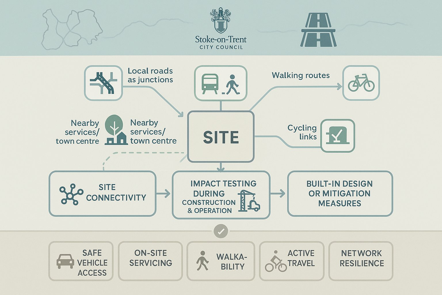
For applicants, this means transport evidence needs to do three things well. First, it must explain the site’s relationship with nearby roads, junctions, public transport, walking routes, and cycling links. Second, it must test whether the development would create material effects during construction and operation. Third, it should show what design or mitigation measures are being built in from the start.
In Stoke-on-Trent, officers and consultees tend to look closely at practical outcomes: can vehicles enter and leave safely, can people walk to nearby services, will servicing work on-site, and does the scheme align with active travel and network improvement ambitions? Those are the questions that shape planning decisions far more than generic transport wording copied in from another authority area.
When A Transport Assessment, Transport Statement, Or Travel Plan Is Likely To Be Required
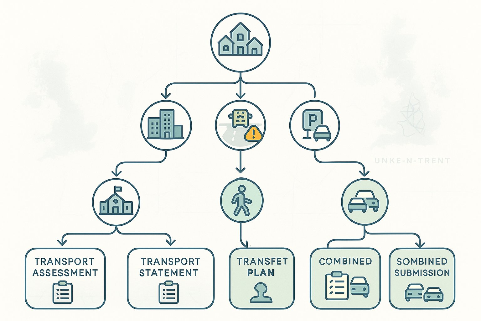
The starting point is always proportionality, but proportionality does not mean guesswork. In Stoke-on-Trent, whether you need a Transport Assessment (TA), a Transport Statement (TS), a Travel Plan, or a combination of these will usually depend on the scale of development, likely trip generation, the sensitivity of the local network, and the nature of the proposed use.
A Transport Assessment is generally expected for major development, or for schemes that could materially affect junction performance, safety, or capacity on key corridors. That includes sites with significant employment floorspace, larger residential schemes, education uses, logistics, roadside development, and proposals near known congestion points.
A Transport Statement is more common for smaller schemes where the transport effects are likely to be limited, but still need to be evidenced properly. It is shorter and lighter than a TA, though it still needs to address access, parking, sustainable travel, and local highway conditions in a credible way.
A Travel Plan is often required where the council wants clear, enforceable measures to reduce single-occupancy car trips and encourage walking, cycling, public transport, car sharing, or smarter travel choices. Major schemes are the obvious candidates, but medium-sized proposals can also trigger this requirement where local sustainability objectives are important.
The real point, frankly, is not the label. It is whether the submitted work matches the likely planning risk. Early scoping with the authority is usually the quickest way to avoid producing too little evidence, or too much of the wrong kind.
How Local Planning Policy And Highway Authority Expectations Shape Applications
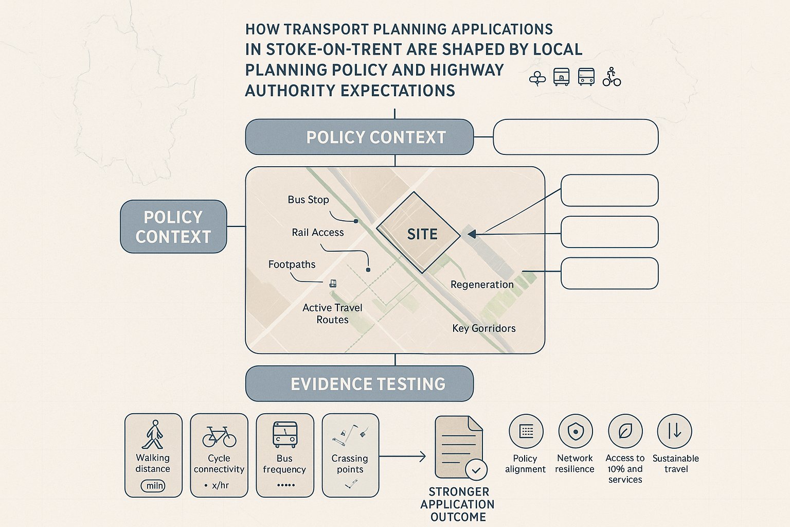
Local policy does not sit in a separate box from technical transport work. In Stoke-on-Trent, policy expectations shape the scope of transport planning from the outset, especially where a site sits on an important corridor, within a regeneration area, or near public transport assets.
The joint strategic transport approach across Stoke-on-Trent and Staffordshire emphasises network resilience, access to employment and services, bus and rail integration, and a gradual shift toward more sustainable travel patterns. That means applications are not assessed solely on whether residual traffic impacts are severe in a narrow highway sense. They are also judged on whether they help deliver better movement outcomes.
This is where local authority expectations become very practical. Officers may expect applicants to reflect current and planned investment in roads, footpaths, bridges, active travel links, or public transport facilities. A scheme that ignores nearby improvement programmes can look undercooked. Equally, one that plugs into them intelligently often reads as more credible and policy-aligned.
We also see a clear preference for site-specific evidence rather than broad assertions. If a development claims to be sustainable, the submission should show real walking distances, crossing points, bus service availability, cycle connections, and likely user behaviour. If it claims negligible highway impact, the analysis should demonstrate why.
For teams preparing planning applications, the lesson is straightforward: transport work should be framed around local policy intent as well as technical compliance. That tends to produce stronger narratives, fewer consultee queries, and fewer awkward late-stage revisions.
Key Transport Issues That Commonly Affect Development Sites In Stoke-On-Trent
Some transport issues turn up again and again in Stoke-on-Trent planning applications. The details vary by site, but the pressure points are familiar: safe access, constrained junctions, the quality of walking and cycling links, public transport realism, and whether the internal layout actually works in day-to-day operation.
Older urban form, mixed land uses, radial routes, local topography, and existing congestion all play a part. A site may appear well located in broad terms, but if it relies on a substandard access, poor visibility, awkward servicing, or broken pedestrian links, concerns emerge quickly. Equally, sites on strategic or busy local roads may face scrutiny simply because there is limited tolerance for extra turning movements or unmanaged conflict.
For applicants, this section is where transport planning becomes less theoretical and more design-led. Small layout decisions can have planning consequences. So can assumptions about how people will actually travel.
Access Design, Visibility, And Highway Safety Considerations
Access design is usually one of the first transport issues examined, and with good reason. If a site cannot be accessed safely by all expected users, the rest of the transport case becomes much harder to defend.
In Stoke-on-Trent, officers will generally expect access arrangements to align with recognised highway design standards, appropriate visibility splays, sensible junction spacing, and a layout that minimises unnecessary conflict between vehicles, cyclists, and pedestrians. On busier roads, new direct accesses may be resisted if they introduce turning movements that harm safety or flow.
Visibility is often treated too casually at concept stage. But boundary features, parking positions, gradients, and the actual speed environment can all affect what is achievable. It is not enough to draw a bell-mouth and assume the details will be solved later.
Road safety evidence can also be pivotal. If there is a history of collisions nearby, or if the design introduces unusual manoeuvres, the authority may want a more detailed safety review. Getting ahead of that issue early is far easier than trying to retrofit a defence after objections land.
Sustainable Travel, Public Transport, Walking, And Cycling Expectations
Stoke-on-Trent transport planning now places clear weight on sustainable travel. That is not just a policy slogan. Decision-makers increasingly expect developments to show genuine opportunities for walking, cycling, and public transport use, particularly where schemes are intended to support regeneration and lower-carbon travel patterns.
A credible submission should assess more than straight-line distances. We need to look at route quality, gradients, crossing opportunities, footway continuity, lighting, surveillance, cycle parking, and whether bus stops are actually convenient and usable. A bus route nearby is helpful, yes, but less so if the stop is difficult to reach or the service pattern is weak.
Walking and cycling links should feel direct and safe, not theoretical. If off-site improvements are needed to make that happen, it is better to identify them openly than gloss over the problem. In some cases, modest interventions such as dropped crossings, footway links, wayfinding, or cycle access upgrades can materially strengthen the planning balance.
Parking, Servicing, And Operational Layout Requirements
Parking and servicing are often underestimated because they seem routine. They are not. Poor internal layout can trigger operational conflict, overspill parking, unsafe reversing, blocked accesses, and objections from both highways officers and neighbours.
A robust transport submission should show that car parking, cycle parking, disabled provision, servicing areas, refuse collection points, and turning space all work together as a coherent arrangement. For commercial and mixed-use schemes especially, swept path analysis and realistic servicing assumptions are usually essential.
Authorities in Stoke-on-Trent will typically expect vehicles to enter, manoeuvre, load if necessary, and leave in a safe and policy-compliant manner. If large vehicles need to reverse onto the public highway, or if parking pressures are simply pushed into surrounding streets, concerns are likely.
And there is a broader point here: operational layout is not separate from placemaking. Efficient parking and service design should support legible pedestrian movement and a safer, less vehicle-dominated environment across the site.
How Trip Generation And Traffic Impact Are Typically Assessed
Trip generation is the backbone of most transport planning evidence. If the forecast number of trips is weak, every downstream conclusion about capacity, safety, sustainability, and mitigation becomes vulnerable.
In Stoke-on-Trent applications, trip rates are usually derived from comparable development data, often supported by established database evidence and tempered by local context. That local context matters a lot. A town-centre site near bus services and walkable facilities should not necessarily be assessed in the same way as an edge-of-network site with heavier car dependence.
Good practice usually involves setting out person trips and vehicle trips clearly, identifying peak periods, and explaining any modal assumptions rather than presenting them as fact. For residential schemes, school travel patterns, commuter peaks, and weekend effects may all be relevant. For employment, retail, or roadside uses, operational peaks can be more nuanced.
Trip distribution and assignment then map those movements onto the surrounding network. This should reflect observed travel patterns, route hierarchy, committed development, and known constraints. If a proposal is likely to load traffic onto already sensitive junctions or corridors, that needs to be shown honestly.
The strongest assessments are transparent. They explain data sources, justify assumptions, include sensitivity testing where appropriate, and avoid the temptation to artificially suppress forecast trips. Highway authorities tend to spot optimistic forecasting very quickly. A realistic assessment, even where impacts need mitigation, is usually far easier to progress than a defensive one that understates the obvious.
Junction Capacity, Network Performance, And Mitigation Strategies
Once trips have been forecast and assigned, the next question is simple: what happens on the network? In practice, this is where many planning discussions become more technical, because junction capacity and network performance can make or break the acceptability of a scheme.
Capacity testing usually considers existing conditions, forecast future baseline conditions, and the scenario with development traffic added. Depending on the site and network, this may involve priority junction modelling, signal junction analysis, roundabout assessment, or broader network-based review. What matters most is choosing methods that fit the real transport issue rather than defaulting to a standard package.
In Stoke-on-Trent, attention often focuses on delay, queue lengths, reserve capacity, and whether effects fall on already pressured links or strategic routes. But interpretation is important. A model output on its own does not tell the whole story. We need to understand whether a change is material in planning terms, how reliable the assumptions are, and whether practical mitigation is available.
Mitigation can take several forms:
- localised junction improvements
- amended access design
- signal optimisation or traffic management measures
- pedestrian and cycle infrastructure upgrades
- public transport support measures
- financial contributions toward wider schemes
The best mitigation is usually proportionate and directly linked to the impact. Not every scheme needs an expensive highway intervention. Sometimes a better internal layout, a refined access, or stronger sustainable travel measures will do more than a headline engineering fix. The key is to show a clear chain between identified impact and proposed response.
The Role Of Travel Plans In Supporting New Development
A Travel Plan should not be treated as a generic appendix bolted on at the end of a transport report. In Stoke-on-Trent, it is often an important part of the planning case because it shows how the development will actively support mode shift rather than merely avoid unacceptable harm.
A good Travel Plan sets out practical measures tailored to the site and the likely occupiers or users. That might include welcome packs, personalised travel information, cycle parking and showers, public transport information boards, car-share initiatives, discounts or ticketing support, electric cycle measures, or the appointment of a Travel Plan coordinator. The exact package depends on land use and scale.
Targets and monitoring are usually critical. Authorities often want to see baseline assumptions, mode share objectives, survey timings, review triggers, and a process for updating measures if performance is weaker than expected. In many cases, these commitments are secured through planning conditions or legal agreement.
The useful thing about a well-written Travel Plan is that it can strengthen several parts of the application at once. It supports sustainability policy, helps justify trip assumptions, demonstrates operational intent, and signals that the applicant is taking transport outcomes seriously.
We find that Travel Plans work best when they are written early enough to influence design. Secure cycle stores, pedestrian links, bus stop improvements, and legible internal routes are much more convincing when they are embedded in the scheme, not added as afterthoughts once objections start to appear.
Common Pitfalls That Delay Planning Decisions
Most delayed transport responses are not caused by unusually difficult sites. They are caused by avoidable mistakes in scoping, evidence, or design coordination.
One common pitfall is insufficient early engagement with the relevant authority. If the scope of the TA, TS, or Travel Plan has not been discussed early, applicants can spend time and money preparing material that does not answer the authority’s actual concerns.
Another is underestimating trip generation or failing to account properly for committed developments and local background growth. That tends to trigger challenge from highways officers very quickly, especially where local junctions are already sensitive.
We also regularly see issues with poor access design: inadequate visibility, substandard geometry, unclear pedestrian priority, or servicing arrangements that do not work in reality. Even where these points can be fixed, they create delay because the transport evidence and the site layout need to be revised together.
A further weakness is thin sustainable travel evidence. Saying a site is in a sustainable location is not enough. If walking routes are discontinuous, bus access is weak, or cycle connections are poor, the report needs to address that head-on.
Finally, road safety evidence is sometimes overlooked. Existing collision patterns, turning conflicts, speed environment, and operational risk should be reviewed properly. If this is missing, consultees may ask for additional analysis late in the process.
None of this is glamorous. But getting the basics right early saves a surprising amount of time.
What To Prepare Early For A Stronger Submission
Stronger applications usually have one thing in common: the transport work starts early enough to influence the scheme, not just justify it.
At the front end, we would typically want to prepare a clear scoping position for discussion with Stoke-on-Trent City Council and, where relevant, Staffordshire County Council or other transport stakeholders. That should cover the likely report type, study area, assessment years, key junctions, committed developments, and whether a Travel Plan is likely to be required.
Next comes baseline evidence. That often includes traffic counts, queue observations, speed data where access design is sensitive, collision records, parking stress if relevant, and a realistic review of walking, cycling, and public transport conditions. Without a solid baseline, later conclusions feel speculative.
Early access options and layout sketches are just as important. These allow us to test visibility, swept paths, servicing logic, pedestrian routes, and parking arrangement before the design hardens. A small change at concept stage is cheap. The same change after submission can be painful.
It also helps to prepare an initial Travel Plan framework early, aligned with local sustainable transport priorities. This can shape cycle parking, footway links, bus stop improvements, and occupier management arrangements from the outset.
At ML Traffic, this is exactly where concise, locally aware reporting tends to add value. Fast turnaround matters, but accuracy and authority-specific judgement matter more. In Stoke-on-Trent, a stronger submission is usually the result of early coordination, local realism, and evidence that feels designed for the site rather than borrowed from somewhere else.
Conclusion
Transport planning in Stoke-on-Trent works best when it is treated as part of development strategy, not a final technical hurdle. The schemes that move more smoothly through planning are usually the ones that engage early, scope properly, test trips honestly, and deal with access, safety, sustainability, and operation in one coherent package.
For architects, planners, lawyers, developers, and local authorities, the practical takeaway is straightforward. Start with the local transport context. Understand which report type is proportionate. Build the site layout around safe access and workable servicing. Assess junction and network effects transparently. And use a credible Travel Plan to support real mode shift, not just policy wording.
In 2026, that joined-up approach matters more than ever. Stoke-on-Trent’s planning context is shaped by regeneration, resilience, and decarbonisation at the same time. Applications that reflect those priorities tend to be easier to defend and faster to progress. The earlier the transport strategy is put in place, the stronger the planning submission usually becomes.
Frequently Asked Questions on Transport Planning in Stoke-on-Trent
What does transport planning in Stoke-on-Trent involve?
Transport planning in Stoke-on-Trent focuses on how a development connects safely to the local highway network, supports regeneration corridors, improves traffic reliability, and encourages sustainable travel such as walking, cycling, and public transport, aligned with local and national policies.
When is a Transport Assessment or Travel Plan required for a development in Stoke-on-Trent?
Major developments or sites generating significant vehicle trips, especially near sensitive junctions, usually require a Transport Assessment and Travel Plan. Smaller schemes may need a lighter Transport Statement, based on local and national guidance and the likely transport impact.
How do local policies influence transport planning applications in Stoke-on-Trent?
Applications are assessed against joint strategic transport priorities like network resilience, access to jobs, and integration with bus and rail. They must align with local active travel and infrastructure investment programmes, ensuring proposals contribute to wider transport and sustainability goals.
What are the common transport issues affecting development sites in Stoke-on-Trent?
Common issues include safe access design, impact on congested junctions and corridors, realistic access to bus and rail services, and the provision of continuous, safe walking and cycling links supporting sustainable travel options.
How is trip generation and traffic impact assessed in Stoke-on-Trent transport planning?
Trip rates are derived from comparable developments and adjusted for local context. The assessment maps peak travel periods and routes onto the local network, using junction or wider traffic models to forecast impacts and identify if mitigation is needed.
What key measures should a Travel Plan include to support sustainable travel in Stoke-on-Trent?
Effective Travel Plans include tailored measures such as personalised travel information, cycle parking, public transport incentives, car-sharing schemes, and monitoring targets. These plans promote mode shift away from single-occupancy cars, supporting local sustainability and regeneration objectives.