In Doncaster, transport planning can make the difference between a planning application that moves smoothly and one that stalls on highway queries, redesigns, or late-stage objections. We see it all the time: a scheme may look strong in land-use terms, but if access is weak, parking is unresolved, or the traffic evidence doesn’t match the site context, the application quickly becomes harder to defend.
That matters because Doncaster is balancing several priorities at once. It wants growth, regeneration, housing delivery, employment land, and better connections to jobs and services. At the same time, the City of Doncaster Council has to protect the safe and efficient operation of its road network, support sustainable travel, and respond to congestion, road safety and air quality concerns. In practice, that means transport evidence needs to be proportionate, locally informed, and technically sound.
This guide explains how transport planning in Doncaster typically works in 2026: what policy context matters, which developments usually trigger a Transport Statement or full Transport Assessment, how sites are reviewed, and where applications often come unstuck. We’ve written it for architects, planners, surveyors, developers, legal teams and local authorities who need a practical picture rather than vague theory. And because every council has its own nuances, we’ll keep the focus firmly on Doncaster’s planning and highways context.
Why Transport Planning Matters For Development In Doncaster
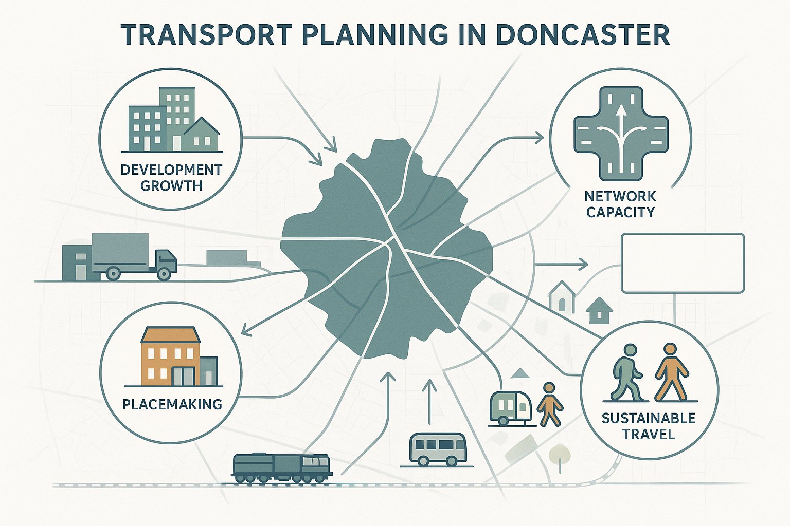
Transport planning matters in Doncaster because growth here is not abstract: it lands on real junctions, school routes, industrial roads, town centre streets and residential areas that already carry pressure at peak times. When a development adds trips, changes vehicle movements, or alters how people reach a site, the council needs confidence that the network can cope safely and efficiently.
At a strategic level, transport supports the borough’s economic role. Doncaster has long been important for logistics, rail, distribution and regional connectivity, and that makes highway performance especially relevant for employment sites, warehousing, mixed-use regeneration and major housing allocations. A poorly considered access strategy on the wrong route can create knock-on effects far beyond the red line boundary.
But it is not only about traffic flow. Good transport planning also helps answer wider planning questions: can residents walk to shops and schools, is there realistic bus access, are cycle connections usable, will servicing work without conflict, and does the design reduce avoidable safety risk? Those issues often shape officer recommendations as much as raw trip numbers do.
In our experience, the strongest applications treat transport as part of placemaking, not a late technical add-on. That approach is particularly valuable in Doncaster, where development is expected to support growth while respecting local network constraints, sustainable travel objectives and the practical realities of day-to-day highway operation.
The Local Planning And Transport Context In Doncaster
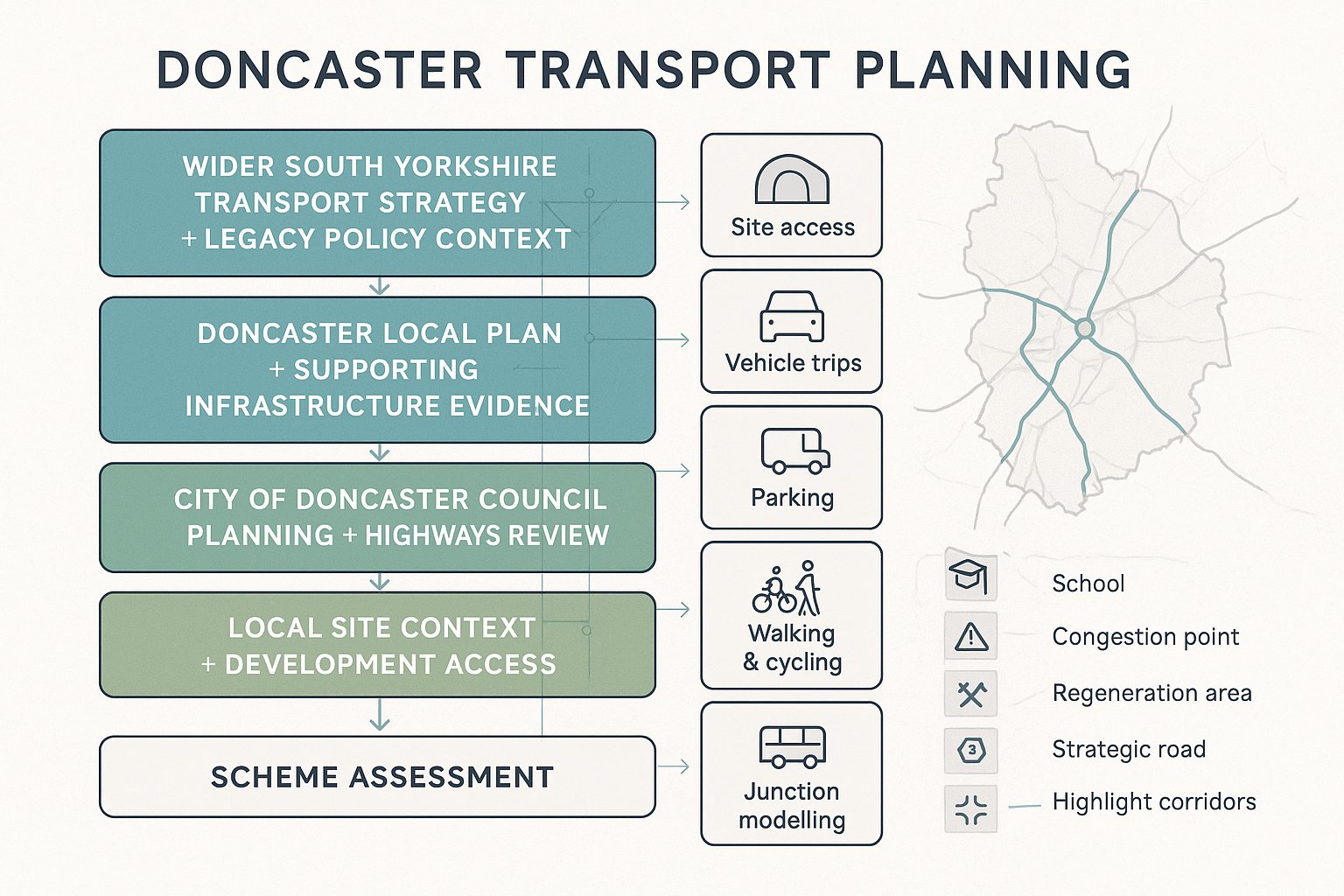
Transport planning in Doncaster sits within a layered policy framework. The starting point is usually the City of Doncaster Council’s own planning and highways processes, but the wider context includes the South Yorkshire Local Transport Plan, the Doncaster Local Plan and, in some circumstances, legacy transportation policies within the Unitary Development Plan that still help explain local expectations around integrating land use and transport.
The council’s Transportation Unit plays a central role in shaping strategy and reviewing how development interacts with the network. For applicants, that means transport evidence needs to do more than tick a national policy box. It should show an understanding of local allocations, corridor pressures, accessibility patterns, and the ambitions behind regeneration and infrastructure planning.
The Doncaster Local Plan is particularly important because it is underpinned by transport and infrastructure evidence. If a site is allocated, that does not remove the need for technical work: it simply means the principle may already have been considered at a broad level. The detailed impacts still need to be tested through access design, trip generation, parking, servicing, sustainable travel and, where necessary, junction modelling.
We also advise clients not to overlook local interpretation. Two schemes of similar size can face very different transport requirements depending on nearby schools, constrained frontage conditions, strategic road sensitivity, or existing congestion. That is why early review of Doncaster-specific policy and site context usually saves time later.
Key Development Types That Commonly Trigger Transport Evidence
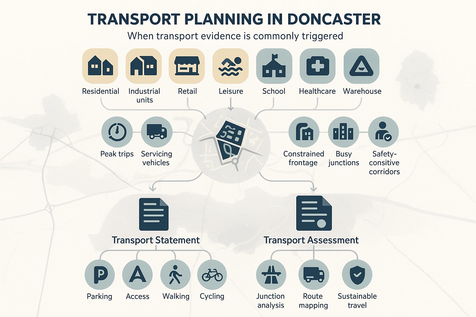
Not every planning application in Doncaster needs a lengthy transport document. But many do require some level of evidence, especially where the use is likely to generate noticeable trips, affect highway safety, or raise questions around accessibility and layout.
The development types that most commonly trigger transport input are fairly predictable: larger residential schemes, employment and industrial development, retail parks, foodstores, leisure uses, schools, healthcare facilities and logistics or warehouse proposals. These uses can create concentrated peaks, higher servicing demand, or significant turning movements at specific times of day.
Mixed-use schemes also deserve close attention because their impacts are often more complicated than a single-use proposal. A site may need to accommodate residents, deliveries, staff parking, short-stay visitors and pedestrian desire lines all at once. In those cases, transport planning becomes the thread that ties the whole layout together.
There is also a sensitivity point that applicants sometimes miss. A scheme does not need to be huge to justify transport evidence. Even modest development can trigger review where it sits on a constrained frontage, near a school, close to a busy junction, or along a corridor with an existing safety record.
When A Transport Statement Is Usually Appropriate
A Transport Statement is usually suitable for smaller or less complex schemes where the traffic impact is expected to be limited and the issues can be addressed proportionately. In Doncaster, that often means development below major application thresholds, with no obvious strategic highway concern and no need for extensive junction modelling.
A good Transport Statement still needs substance. We would expect it to cover site context, access arrangements, parking and servicing, sustainable travel opportunities, and a reasoned view of likely traffic effects. If the proposal relies on assumptions that are too light-touch, the document can quickly lose credibility.
When A Full Transport Assessment May Be Needed
A full Transport Assessment is more likely for major schemes, developments with significant trip generation, or sites in sensitive locations. That includes proposals near congested junctions, on important distributor routes, close to schools, or where HGV movements are material.
In Doncaster, a full assessment is often needed where the council must understand not just whether trips increase, but how they route, which junctions are affected, whether mitigation is required, and how sustainable travel will be supported. Travel Plans commonly sit alongside these submissions, especially for employment, education, larger residential and mixed-use development.
How Doncaster Sites Are Typically Assessed
Most transport assessments in Doncaster follow a recognisable sequence, although the depth varies by scheme. First, we review the policy and planning context: local plan status, nearby allocations, road hierarchy, sustainable travel expectations, and any site-specific constraints already identified through planning history or pre-application discussions.
Then comes the baseline. That normally includes the surrounding highway layout, speed environment, existing access conditions, personal injury collision data where relevant, traffic flows, nearby junction performance, and the availability of walking, cycling and public transport links. This stage matters more than many applicants think. If the baseline is poorly captured, the rest of the assessment can wobble.
Trip generation and assignment follow. Depending on the development type, this may involve using survey databases, local census context, committed development review, and professional judgement to estimate arrivals and departures. For larger schemes, we usually test how those trips distribute across the surrounding network and whether key junctions need modelling.
Just as importantly, Doncaster site assessments tend to look beyond vehicles. Officers will often want to understand whether people can realistically reach the site by foot, cycle or bus, whether internal routes are legible and safe, and whether the proposed design creates obvious conflict points.
The practical point is simple: a robust assessment in Doncaster is rarely just a traffic note. It is an integrated review of access, capacity, safety, layout and sustainable travel.
Access, Visibility, And Highway Safety Considerations
Access design is usually one of the first things reviewed by highway officers, and for good reason. If vehicles cannot enter and leave safely, or if visibility is inadequate for the speed environment, the rest of the transport case becomes much harder to support.
In Doncaster, applicants should expect close scrutiny of access geometry, junction spacing, radii, gradient, boundary treatment and the effect on existing highway assets such as footways, verges, signs, lighting columns and drainage features. Visibility splays are a recurring issue. On paper, an access may appear feasible: on site, walls, vegetation, parked vehicles or vertical alignment can reduce what is actually achievable.
Highway safety is broader than simple compliance with visibility standards. We also need to consider how pedestrians cross the site entrance, whether cyclists are put into conflict with turning vehicles, whether servicing blocks sightlines, and whether driver behaviour is likely to be affected by nearby junctions, bends, schools or bus stops.
Collision data can be useful here, though it needs careful interpretation. A clean record does not automatically prove an arrangement is acceptable, and a cluster does not always mean a new scheme is unacceptable. What matters is whether the proposal introduces or worsens a credible safety problem.
This is often where early measured surveys earn their keep. We’d far rather identify an access constraint before the layout is fixed than try to explain away a design that was always marginal.
Parking, Servicing, And Internal Site Layout Requirements
Parking and servicing regularly decide whether a scheme feels operationally realistic. A site may satisfy gross policy requirements, but if the internal layout is awkward, over-tight or conflict-heavy, the council may still push back.
In Doncaster, parking provision is usually reviewed against the nature of the use, likely demand, accessibility by non-car modes, and local standards or guidance. Too little parking can displace vehicles onto surrounding streets: too much can undermine sustainability objectives and weaken the site layout. The right answer is rarely just ‘more spaces’. It is the right mix of spaces, in the right place, with safe manoeuvring and good pedestrian routes.
Servicing deserves equal attention. Refuse vehicles, delivery vans and HGVs need to enter, turn, load and leave without unsafe reversing onto the highway wherever possible. Swept path analysis is often essential for commercial, industrial, education and apartment schemes, yet it is still surprisingly common to see it left until late in the process.
Internal circulation should work for everyone: cars, larger vehicles, cyclists, pedestrians, and people with mobility impairments. That means considering aisle widths, tracking, crossing points, kerb lines, secure cycle parking, footway continuity and the relationship between entrances and parking courts.
Where we see applications struggle is when parking, servicing and layout are designed separately. In reality, they are one operational system. If one part fails, the whole transport strategy starts to look less convincing.
Sustainable Travel Expectations For New Development
Doncaster does not assess development only through a car-based lens, and neither should applicants. Sustainable travel expectations are now embedded in local and regional transport thinking, particularly through the South Yorkshire Local Transport Plan and wider planning policy emphasis on reducing unnecessary car dependence.
For most schemes, the council will want to know whether future users can walk, cycle or use public transport in a realistic, everyday way. That means looking at actual route quality rather than simply drawing lines on a plan. Is the footway continuous? Can people cross safely? Are bus stops within a sensible distance and served at useful times? Is cycle parking secure and convenient rather than tucked away as an afterthought?
This matters for all kinds of development, but especially housing, schools, offices and town-centre or edge-of-centre schemes where mode choice can materially influence trip patterns. Even logistics and employment sites, which are often more vehicle-oriented, need to show how staff can access the location without relying entirely on private cars.
In practical terms, sustainable travel measures can include improved pedestrian links, cycle parking and changing facilities, bus stop upgrades, route signage, crossing improvements and information packs for future users. The strongest submissions tie these measures to the actual deficiencies of the site, not generic sustainability language.
Travel Plans And Measures To Support Mode Shift
Where a Travel Plan is required, it should be more than a standard appendix. In Doncaster, a credible Travel Plan explains who will use the site, how they are likely to travel, what barriers exist to mode shift, and which measures can realistically influence behaviour over time.
Typical measures include public transport information, discounted ticket initiatives, cycle facilities, car-share promotion, welcome packs, appointment of a Travel Plan coordinator, and monitoring with review triggers. For residential schemes, the emphasis may be on local information, cycle storage and route awareness. For schools or employment uses, management actions and survey-based monitoring tend to carry more weight.
A weak Travel Plan often fails because it is too generic. A useful one is tailored, phased, and linked to the design of the site itself.
Junction Capacity, Traffic Impact, And Mitigation Options
Once a scheme reaches a certain scale, or sits in a sensitive location, junction capacity becomes central to the planning discussion. The key question is not just whether traffic increases, but whether that increase would create severe effects, worsen existing operational problems, or undermine safety and reliability on the surrounding network.
In Doncaster, that often means assessing priority junctions, roundabouts, signalised intersections or site access points that already experience stress in peak periods. The methodology should fit the problem. Some schemes need only a proportionate review and reasoned forecast. Others require formal modelling, queue assessment and sensitivity testing, especially where nearby committed development may alter future background flows.
Trip generation is where many transport reports are won or lost. If assumptions are too optimistic, every downstream conclusion becomes vulnerable. We usually advise a transparent approach: explain survey sources, justify modal assumptions, account for pass-by or linked trips carefully, and sense-check the results against the local context.
Where impacts are identified, mitigation can take several forms. Sometimes it is geometric: a ghost island right-turn lane, altered lane markings, improved visibility, a revised access arrangement or an upgraded junction. Sometimes it is behavioural or strategic: crossing improvements, bus stop enhancements, Travel Plan measures, traffic management changes, or financial contributions to wider network schemes.
The best mitigation is proportionate and deliverable. There is little value in proposing an impressive package that cannot be funded, approved or physically accommodated.
Common Transport Planning Risks That Delay Applications
Most transport-related delays in Doncaster are avoidable. They tend to arise not from unusual technical disputes, but from fairly ordinary gaps in preparation.
One of the biggest problems is submitting the wrong level of evidence. If a scheme clearly needs a Transport Assessment and only a brief statement is provided, officers will ask for more, consultation periods may stretch, and confidence in the application can dip. The reverse can also happen: an overblown document that never gets to the real local issues. Proportion matters.
Another common risk is leaving transport too late. We often see site layouts fixed before vehicle tracking, access geometry, parking demand or refuse collection are properly tested. By that point, transport advice starts to feel like bad news rather than useful design input.
Safety and sustainable travel are also frequent weak spots. Applicants may focus heavily on junction capacity while giving little attention to walking routes, bus accessibility, visibility splays or collision history. In Doncaster, those omissions are rarely overlooked.
Then there is local nuance. A technically polished report can still struggle if it ignores council-specific expectations, nearby committed development, local school peak conditions, or the practical operation of the frontage road.
For us, the lesson is straightforward: strong transport planning is not about producing the thickest report. It is about asking the right questions early, with evidence that matches the scale and sensitivity of the scheme.
What To Prepare Before Submitting A Planning Application
Before submitting a planning application in Doncaster, we recommend treating transport as a submission package rather than a single report. That usually starts with early engagement. Pre-application discussion with the council’s transportation and highway development control teams can clarify likely scope, key junctions, access concerns, and whether a Travel Plan or specific modelling will be expected.
The core documents often include a draft Transport Statement or Transport Assessment, depending on the scale of the proposal. Alongside that, access drawings should be sufficiently developed to demonstrate geometry, visibility and relationship to the existing highway. If larger vehicles are involved, swept path plans are normally essential.
Parking and servicing strategy should also be prepared before submission, not improvised afterwards. We would usually want to see parking numbers and types, cycle parking, disabled provision, servicing arrangements, turning strategy and refuse collection assumptions clearly set out. For many schemes, an initial Travel Plan is also sensible at application stage, even if detailed monitoring arrangements are secured later.
It is equally helpful to assemble baseline evidence early: traffic counts where needed, site photographs, speed data if visibility is a live issue, and a concise review of walking, cycling and bus accessibility. This up-front work often shortens determination because it reduces the number of basic questions officers need to ask.
At ML Traffic, this is exactly where concise, locally tailored reporting makes a difference. With the right evidence in place from the start, applications stand a much better chance of moving through Doncaster’s planning process without unnecessary transport-related friction.
If there is one practical takeaway, it is this: in transport planning in Doncaster, early coordination beats late correction nearly every time. A well-scoped report, workable access design, credible parking and servicing strategy, and realistic sustainable travel measures will usually do more for planning success than pages of generic technical wording. Doncaster’s framework is not impossible to navigate, but it does reward preparation, local knowledge and proportionate evidence. Get those pieces aligned early, and the transport element of an application becomes far easier to defend.
Transport Planning FAQs for Doncaster Developments
Why is transport planning important for development in Doncaster?
Transport planning supports Doncaster’s economic growth, regeneration, housing, and employment goals while ensuring the road network operates safely and efficiently. It addresses congestion, road safety, air quality, and access to jobs, education, and healthcare.
What types of developments in Doncaster typically require transport evidence?
Key developments needing transport evidence include larger residential schemes, employment and industrial sites, retail parks, leisure uses, schools, healthcare facilities, and logistics or warehouse proposals, especially those generating significant traffic or service demand.
When is a Transport Statement sufficient for a Doncaster planning application?
A Transport Statement is usually appropriate for smaller or less complex schemes with limited traffic impact and no major highway or junction concerns, often below local or national thresholds and without the need for detailed junction modelling.
Under what circumstances does Doncaster require a full Transport Assessment?
Major developments with significant trip generation, sites near congested junctions, strategic routes, schools, or with heavy goods vehicle movements require a full Transport Assessment, often accompanied by a Travel Plan to manage sustainable travel and mitigation measures.
How does Doncaster assess the impact of a development on transport?
Assessment includes reviewing policy context, baseline traffic and collision data, trip generation and assignment, junction modelling if needed, plus evaluating walking, cycling, and public transport accessibility to ensure safe and efficient site layout and operation.
What measures does Doncaster expect to promote sustainable travel in new developments?
Developments should provide good walking and cycling links, accessible bus stops, secure cycle parking, and travel plans encouraging public transport use and mode shift, aligning with South Yorkshire Local Transport Plan objectives to reduce car dependency.