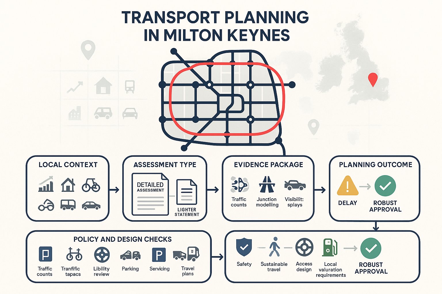
Milton Keynes has always done transport a little differently. Wide grid roads, grade-separated junctions, redways, generous spacing between neighbourhoods, on paper, it can feel like a planner’s dream. In practice, though, that very structure creates a demanding test for new development. If a scheme adds traffic in the wrong place, misses a safe access detail, or leans too heavily on car travel without credible alternatives, planning friction arrives fast.
That’s why transport planning in Milton Keynes matters so much in 2026. For architects, developers, planning consultants, land promoters, legal teams and local authorities, the transport work behind an application is rarely a box-ticking exercise. It often shapes whether a proposal is considered acceptable at all, what mitigation is needed, and how quickly an application moves.
We see this regularly: a modest scheme that needs only a proportionate Transport Statement can progress smoothly with the right evidence, while a larger site with unclear trip impacts, weak access design or poor alignment with local policy can stall. Milton Keynes City Council expects transport submissions to be grounded in local validation requirements, realistic assumptions and the city’s wider growth strategy.
In this guide, we set out the practical essentials, when a Transport Assessment or Statement is likely to be needed, which policy documents matter most, what technical evidence typically supports an application, and where the common delay points sit. The aim is simple: help you prepare transport planning work that is robust, proportionate and far more likely to succeed.
Why Transport Planning Matters In Milton Keynes
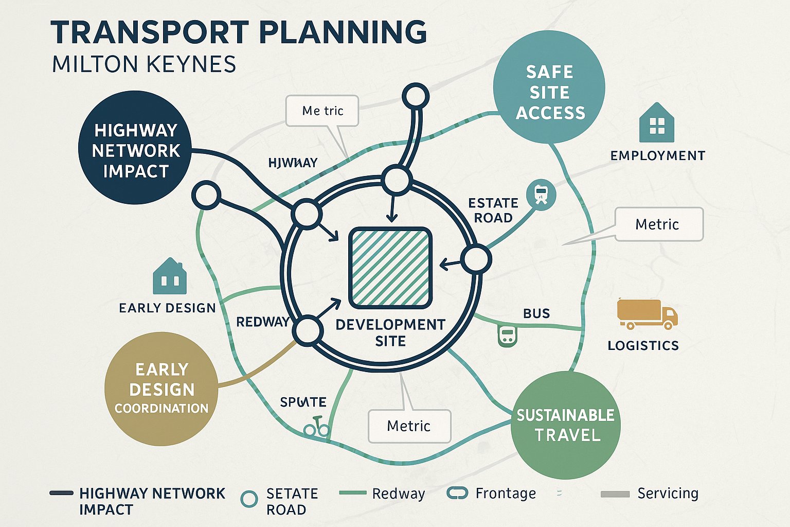
Milton Keynes is not a place where generic transport planning advice always travels well. The city’s road hierarchy, development pattern and growth ambitions create a very specific planning context. For applicants, that means transport is often central to the decision-making process rather than a secondary technical appendix.
At application stage, the key questions are usually straightforward, even if the analysis behind them is not: will the development create unacceptable impacts on the highway network, can people reach the site safely, and does the scheme genuinely support sustainable travel rather than simply rely on private car use? Those tests sit at the heart of both local and national planning decision-making.
This is especially important in Milton Keynes because the transport network has historically been designed around efficient movement. That strength can become a weakness if growth is layered onto the network without careful assessment. High-speed approaches, major roundabouts, multiple turning movements and dispersed land uses mean even relatively ordinary-looking sites can need detailed access and junction work.
For project teams, early transport planning also reduces risk elsewhere. It informs site layout, servicing strategy, parking design, frontage treatment, travel planning commitments and often viability conversations around off-site works. In short, it helps avoid the expensive situation where a scheme is designed first and tested second.
The Milton Keynes Context: Growth, Grid Roads, And New Development Pressures
Milton Keynes was planned as a new town with freedom of movement built into its DNA. The grid road system, estate roads, separated walking and cycling routes and strategic land allocations all reflect that original logic. It still works in many ways, but it also means transport evidence has to engage with a network that is fast-moving, highly structured and sensitive to cumulative growth.
The pressure point is growth. Milton Keynes has continued to expand through housing, employment and logistics development, while also trying to reduce car dependency and improve conditions for walking, cycling and public transport. That balancing act is not simple. Car ownership remains high compared with many urban areas, and dispersed destinations can make modal shift harder unless developments are planned carefully from the outset.
This is where local knowledge becomes valuable. A site may appear close to a grid road and hence “well connected”, but that says very little on its own. We need to consider crossing points, redway continuity, bus accessibility, nearby junction performance, and whether the surrounding street network actually supports the kind of travel behaviour policy now expects. Milton Keynes rewards detailed, place-specific transport planning, and tends to expose vague or standardised submissions quite quickly.
When A Transport Assessment Or Statement Is Needed
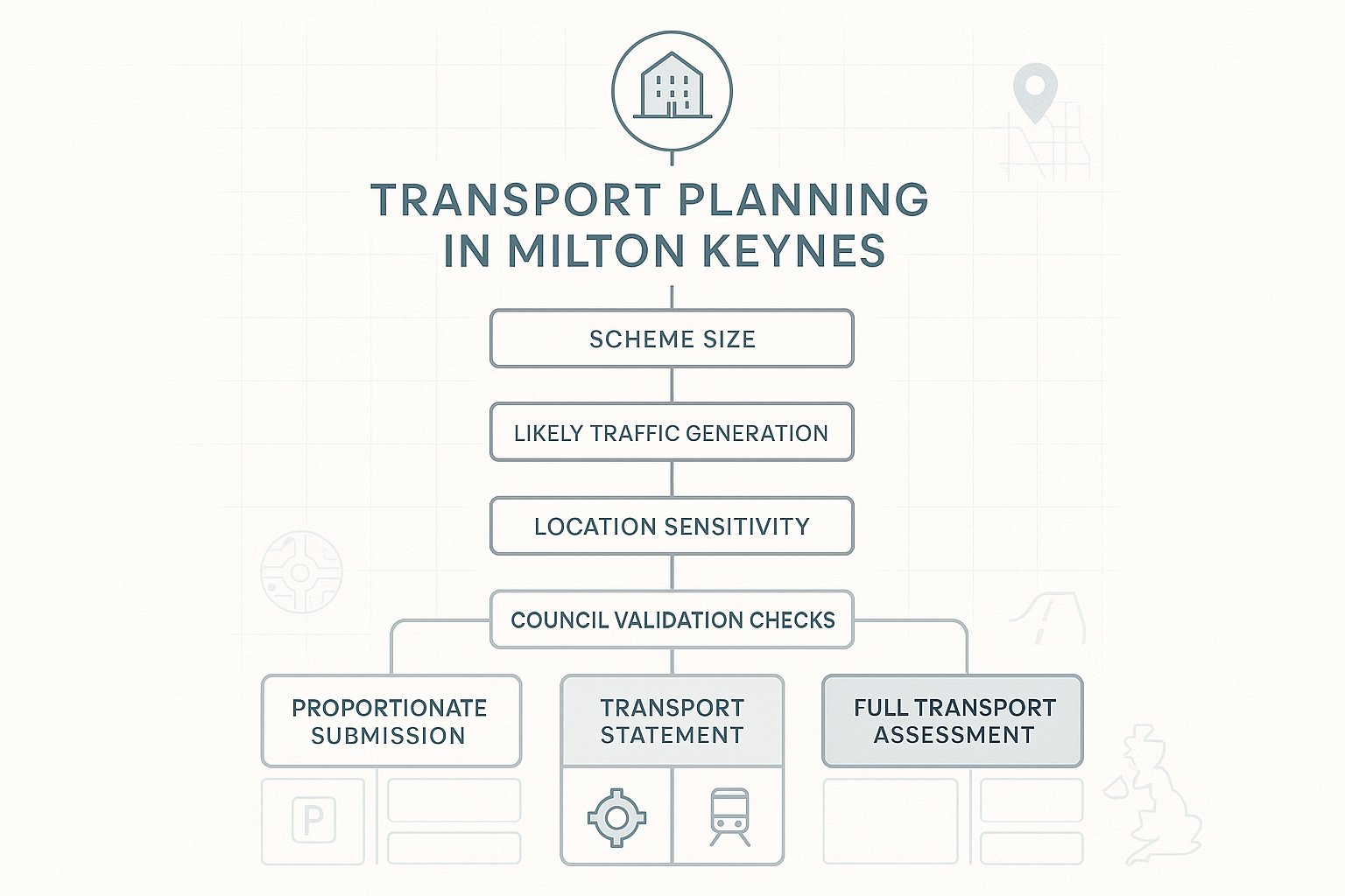
One of the first questions on any planning project is whether the application needs a full Transport Assessment (TA), a lighter-touch Transport Statement (TS), a Travel Plan, or a package of supporting transport material. In Milton Keynes, the answer depends on the scale and type of development, the likely trip impact, and the sensitivity of the location.
As a rule, larger schemes or those likely to generate material traffic effects will require a TA. Smaller or lower-impact proposals may only need a TS. But we would strongly caution against relying on broad national assumptions alone. Milton Keynes City Council’s local validation requirements are critical, and they can trigger transport documents based not only on size thresholds but also on site-specific considerations such as constrained access, local highway conditions or sustainable travel expectations.
That means two schemes of similar floor area may not need exactly the same level of assessment. A small infill development on a simple urban frontage may justify a proportionate submission. A similar-sized proposal fronting a busier road, affecting a roundabout, or creating servicing conflicts may require more detailed analysis. Context matters.
From a practical perspective, the earlier this is scoped, the better. Waiting until submission is being assembled often leads to rushed surveys, poor-quality assumptions and avoidable validation delays.
How Local Validation Requirements And Thresholds Shape Applications
Local validation lists are not glamorous documents, but in Milton Keynes they can save weeks of delay if taken seriously at the start. They set out what supporting material is expected for planning applications, including transport assessments, statements, travel plans, parking details, access information and technical drawings.
These requirements shape applications in three main ways.
First, they determine what must be submitted for the application to be validated. If the right transport documents are missing, the application may simply not progress.
Second, they affect the quality threshold. A transport report that technically exists but fails to address local requirements, say, parking strategy, servicing arrangements or sustainable access expectations, may trigger further information requests and slow determination.
Third, they influence proportionality. Applicants sometimes assume that “smaller scheme” automatically means “minimal transport work”. Not always. In Milton Keynes, a smaller application in a sensitive location can still require robust evidence on access geometry, traffic impact, collision history, parking stress or active travel links.
Our approach is usually to check the local validation position, review likely trip rates and access issues, then agree scope early with the local authority where possible. That front-loads the effort a little, but it tends to produce cleaner applications and fewer surprises later.
Core Transport Planning Documents For Planning Applications
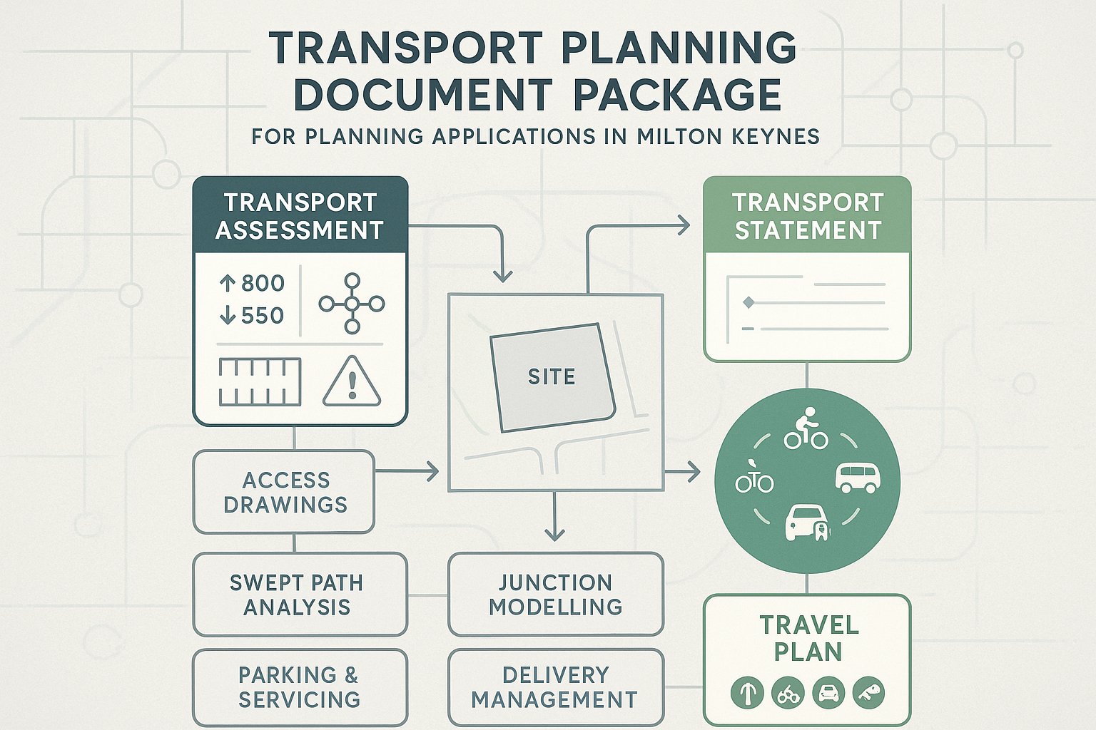
Most transport planning submissions in Milton Keynes revolve around a fairly familiar set of documents, but the quality of those documents, and how well they fit together, makes all the difference. A strong package is proportionate, policy-led and specific to the site. A weak one is generic, over-optimistic and disconnected from the development proposals.
The usual core documents include:
- a Transport Assessment for developments with more substantial traffic and transport implications:
- a Transport Statement for lower-impact schemes where a concise, evidence-based review is enough:
- a Travel Plan, often residential, workplace or school-related depending on the use:
- access drawings and swept path analysis:
- parking and servicing information:
- and, where necessary, junction modelling, road safety analysis or delivery management details.
Not every application needs every document. But the underlying principle is consistent: the planning authority needs enough evidence to judge whether the proposal is safe, suitable, policy-compliant and acceptable in network terms.
This is where concise technical writing matters. At ML Traffic, we’ve found that planning teams rarely benefit from over-engineered reporting for its own sake. What they need is a clear transport case: what the development does, what impacts arise, what standards apply, and what mitigation or management is proposed.
Transport Assessments, Transport Statements, And Travel Plans Explained
A Transport Assessment is the most detailed of the three. It typically covers baseline conditions, accessibility, trip generation, trip distribution, assignment, junction capacity, road safety, servicing, parking and mitigation. For larger housing, employment, mixed-use or education schemes in Milton Keynes, it is often the principal transport document and may be supported by appendices with traffic counts, modelling outputs and technical notes.
A Transport Statement is lighter but still evidence-based. It is generally appropriate where development impacts are modest and can be assessed without full modelling or extensive strategic analysis. That does not make it casual. A good TS still needs to explain site conditions, access arrangements, likely trips, parking strategy and sustainable travel opportunities in a way that gives officers confidence.
A Travel Plan is different again. It is less about measuring impact and more about influencing behaviour. In Milton Keynes, Travel Plans are often expected to set out practical measures to encourage walking, cycling, bus use, car-sharing and, increasingly, lower-emission travel choices. Targets, monitoring and implementation responsibilities matter here.
The mistake we sometimes see is treating the Travel Plan as a generic afterthought. In reality, it should connect closely to the development itself, who will travel, where they are likely to go, and what realistic alternatives to driving can actually be supported on that site.
Key Policy And Guidance To Consider In Milton Keynes
Transport planning in Milton Keynes sits at the intersection of local policy, transport strategy and national planning guidance. If an application is to stand up well, the transport case needs to do more than present data: it must show how the proposal aligns with the policy framework that decision-makers are using.
At local level, Milton Keynes’ transport direction is shaped by the Local Transport Plan 5 (LTP5), which sets priorities around network performance, active travel, public transport, safety and supporting growth. For applicants, this matters because it frames the authority’s expectations. It is not enough to avoid severe traffic impact: schemes are also expected to contribute positively to a more sustainable and connected transport system.
The Transport Infrastructure Delivery Plan (TIDP) is also important. It links planned growth with infrastructure needs and funding mechanisms. On larger sites especially, this can affect whether a proposal is expected to provide on-site measures, off-site highway works, public transport support or financial contributions.
Then there is the development plan and national policy context. The National Planning Policy Framework (NPPF) remains central, particularly its tests around safe and suitable access, promoting sustainable transport, and the familiar threshold that development should only be refused on highways grounds if there would be an unacceptable impact on highway safety or the residual cumulative impacts on the road network would be severe.
That wording matters. In practice, but, getting to a comfortable planning position often requires more than just scraping under a severe-impact threshold. A scheme that aligns with local policy on walking, cycling, bus access, parking and place quality is usually in a much stronger position than one arguing narrowly from capacity numbers alone.
We also need to account for local standards and design guidance where applicable, parking requirements, cycle parking expectations, electric vehicle charging provision, servicing needs and access design principles. In Milton Keynes, policy compliance is rarely achieved through one headline point. It comes from showing that the whole transport strategy, from site access to mode share ambition, has been thought through coherently.
Site Access, Highway Safety, And Junction Capacity Considerations
This is often the section of transport planning that gets the most scrutiny, and with good reason. But sustainable a development may aspire to be, it still needs to function safely and efficiently on the ground. In Milton Keynes, that usually means close attention to access design, visibility, road hierarchy, roundabout operation and the relationship between the site and the wider grid road network.
The first test is whether access is safe and suitable for all users. That includes cars, service vehicles, refuse collection, pedestrians, cyclists and, where relevant, buses. Geometry matters. Visibility splays matter. Speed environment matters. And in Milton Keynes, where some roads operate at relatively high speeds and with generous carriageway widths, designing access that is technically compliant yet genuinely comfortable for vulnerable users can take more thought than expected.
Highway safety review should be more than a checklist exercise. We normally want to understand existing collision patterns, crossing opportunities, potential conflict points and whether the proposal introduces awkward manoeuvres or pressure on nearby junctions. If a site has constrained frontage, limited inter-visibility, unusual levels, or heavy servicing demand, these issues need addressing early, not buried in an appendix.
Junction capacity is the next major consideration. Depending on scale and location, affected roundabouts, priority junctions or signalised nodes may need assessment using recognised modelling tools. In Milton Keynes that often includes key grid road junctions and strategic roundabouts that can look resilient until cumulative traffic from committed development is layered in. The cumulative point is important: local authorities will expect analysis to account for consented and allocated growth where relevant, not just the development in isolation.
Mitigation can take many forms: access widening, lane marking changes, signal optimisation, pedestrian crossing improvements, travel plan measures, bus stop enhancements or financial contributions to wider works. But mitigation has to be credible. If the only way a scheme becomes acceptable is through vaguely worded future interventions, planners and highway officers are unlikely to be reassured.
Done properly, access and capacity work does two things at once: it reduces technical objection risk, and it gives the wider consultant team a more stable basis for design decisions. That’s a very worthwhile payoff.
Sustainable Travel Expectations For New Development
The planning conversation in Milton Keynes is no longer just about whether the roads can cope. It is also about whether a development supports a healthier, lower-car and more balanced pattern of movement. That is a significant shift from older assumptions about the city, and applicants who ignore it tend to find their transport strategy looking dated very quickly.
In practical terms, new development is generally expected to prioritise sustainable travel from the outset. That means more than adding a line in a report about nearby bus stops. The site layout, frontage design, cycle parking, walking routes, crossing provision, parking restraint and Travel Plan measures should all point in the same direction.
For residential schemes, the focus is often on whether people can realistically walk or cycle to schools, local centres, open space, employment and public transport. For commercial development, the emphasis may be on staff travel, shift patterns, servicing management and how non-car access works in practice. Different land uses generate different travel challenges, but the policy expectation is broadly consistent: make sustainable choices easier and more credible.
Milton Keynes has an advantage here in the form of its redway network and planned urban structure. But that advantage only counts if developments actually connect into it well. A redway half-near the site, reached via a poor crossing or indirect route, does not deliver the same benefit as a direct, legible and safe connection.
Walking, Cycling, Public Transport, And Parking Strategy
A convincing sustainable transport strategy usually needs four linked parts.
Walking comes first because it underpins almost every trip. We need to look at directness, footway continuity, crossing quality, accessibility for disabled users, lighting, surveillance and whether key local destinations are reached by routes people would realistically choose.
Cycling in Milton Keynes is shaped heavily by the redway network. That is a genuine asset, but developments should still provide strong on-site connections, clear links to surrounding routes, secure and convenient cycle parking, and layouts that don’t make cycling feel like an afterthought. End-of-trip facilities can also matter on employment sites.
Public transport requires an honest appraisal. How far are the stops? What service frequency exists? Are routes useful for likely trip destinations? Would bus penetration into the site improve accessibility? On some schemes, contributions toward stop upgrades, shelters, real-time information or service support may be necessary to make the offer credible.
Parking strategy often determines whether the rest of the sustainable narrative feels believable. Too little parking can create overspill and neighbour objection: too much can lock in car dependency and consume valuable land. Milton Keynes applications should address parking quantum, layout, disabled provision, cycle parking, servicing interfaces and EV charging in line with local standards. The best parking strategies are not just compliant, they are clearly integrated with the site’s broader movement plan.
The Role Of Technical Evidence And Surveys
Transport planning arguments are only as good as the evidence beneath them. In Milton Keynes, where applications may turn on a junction’s peak-hour operation, an access visibility constraint or the realism of non-car travel options, technical evidence is not decoration. It is the backbone of the planning case.
Typical survey work includes classified traffic counts, turning counts at nearby junctions, queue length observations, journey time surveys, speed data, parking beat surveys and site accessibility audits. Depending on the proposal, we may also need personal injury collision analysis, servicing observations, census travel-to-work data, TRICS-based trip generation analysis or public transport availability review.
The purpose of this evidence is not simply to produce tables. It establishes the baseline against which impact is judged. It allows trip generation to be tested against local conditions. It informs whether a roundabout is likely to operate within capacity, whether a crossing is needed, whether parking stress already exists, or whether a Travel Plan target is remotely realistic.
Quality control matters a lot here. Surveys need to be undertaken at appropriate times, in neutral conditions where possible, and with enough clarity that results can be defended. Old data, school holiday surveys, incomplete turning counts or poorly explained assumptions can undermine an otherwise solid application.
We also need proportionality. Not every proposal needs a mountain of appendices. But every application does need enough reliable evidence to support its conclusions. In our experience, the strongest submissions are those where the technical work is clearly tied back to planning judgment: this is what the surveys show, this is why it matters, and this is how the scheme responds.
That connection between data and decision is where transport planning earns its keep. A good report does not overwhelm officers with raw material: it interprets the evidence carefully and uses it to answer the real planning questions.
Common Transport Planning Risks And How To Avoid Delays
Most transport-related planning delays in Milton Keynes are not caused by one dramatic fatal flaw. They come from smaller issues compounding: unclear scoping, inconsistent assumptions, late survey work, weak access detail, or mitigation that is mentioned but not properly resolved. The good news is that these risks are largely manageable if identified early.
A common problem is insufficient pre-application engagement. Where the likely scope is uncertain, applicants benefit from opening a dialogue with the local planning authority and, where appropriate, highway officers. Agreeing the need for a TA or TS, likely study junctions, survey periods and broad methodology can prevent disputes later.
Another frequent issue is trip generation that feels too optimistic. If rates are selected without proper justification, or local context and committed development are ignored, confidence in the whole submission can drop. The same applies to distribution and assignment assumptions that appear convenient rather than evidenced.
We also see delays caused by access and layout design evolving separately from transport advice. A transport report may assume one form of access while the planning drawings show another. Parking numbers may not match. Swept path tracking may be missing for servicing. Those inconsistencies are surprisingly common, and entirely avoidable.
Mitigation is another pressure point. If a junction is shown to be stressed, but the proposed solution is vague, uncosted or left for a future stage without agreement, objections can harden quickly. A more effective route is to identify mitigation early, test it properly and present it as part of a coherent package.
Finally, there is the risk of generic reporting. Milton Keynes is distinctive enough that boilerplate transport text stands out. Reports should reflect the city’s grid roads, redways, growth context, local validation requirements and current policy direction.
In practice, avoiding delays comes down to a few disciplined habits: scope early, survey properly, align transport work with the design team, and write reports that answer local planning concerns directly. It sounds simple. It isn’t always easy. But it is usually what separates smooth applications from painful ones.
Conclusion
Transport planning in Milton Keynes is, above all, about fit: fit with the grid road network, fit with local validation requirements, fit with policy, and fit with the city’s push toward safer and more sustainable travel. When that fit is weak, delays and objections tend to follow. When it is strong, transport work can actively help unlock planning success.
For applicants in 2026, the message is fairly clear. Start early. Scope the right level of assessment. Build the transport strategy around the real characteristics of the site rather than generic assumptions. And make sure the evidence, design and policy narrative all point in the same direction.
Whether a scheme needs a concise Transport Statement or a more detailed Transport Assessment, the standard should be the same: clear reasoning, robust data and practical recommendations. That is usually what planning officers, highway authorities and project teams need most.
If the transport case is proportionate, locally informed and technically sound, Milton Keynes is a place where good development can be supported. But it rarely happens by accident.
Transport Planning in Milton Keynes: Frequently Asked Questions
Why is transport planning so important in Milton Keynes?
Transport planning in Milton Keynes is crucial due to its high car ownership and fast-moving grid road system. Proper planning ensures developments provide safe access, do not overload junctions, and promote sustainable travel, helping to manage congestion and maintain road safety amid rapid growth.
When is a Transport Assessment or Transport Statement required for developments in Milton Keynes?
A Transport Assessment is generally needed for larger developments or those likely to significantly impact traffic, while smaller or lower-impact schemes may only require a Transport Statement. The exact requirement depends on development size, location sensitivity, and local validation criteria set by Milton Keynes City Council.
How does Milton Keynes’ grid road system impact transport planning for new developments?
Milton Keynes’ grid road system, with its wide, fast roads and major roundabouts, creates unique challenges. Developments must carefully assess safe site access, junction capacity, and the integration with the network to avoid congestion or safety issues, making site-specific transport planning essential.
What sustainable travel measures are expected for new developments in Milton Keynes?
New developments are expected to prioritise walking, cycling, and public transport by providing strong connections to the redway network, safe crossing points, secure cycle parking, access to frequent bus services, and parking strategies that discourage car dependency, aligning with local policies promoting healthier travel choices.
What key transport policy documents should developers consider when planning in Milton Keynes?
Developers should refer to Milton Keynes’ Local Transport Plan 5 (LTP5), the Transport Infrastructure Delivery Plan (TIDP), local validation requirements, and national guidance like the National Planning Policy Framework (NPPF) to ensure transport plans align with strategic priorities, infrastructure funding, and safety standards.
How can applicants avoid common delays in Milton Keynes transport planning approvals?
To avoid delays, applicants should engage early with Milton Keynes Council for scope agreement, use realistic trip generation backed by local data, ensure access and parking layouts comply with standards, provide clear mitigation measures, and submit concise, locally tailored reports addressing policy and network specifics.