Manchester is not a place where transport can be treated as a bolt-on at the end of design. A scheme can look strong in planning terms, stack up commercially, and still run into avoidable delay if access, servicing, trip impact, active travel, or public transport links haven’t been addressed properly from the outset. That is why transport planning Manchester work has become such a central part of the planning application process.
For architects, planning consultants, developers, lawyers, surveyors and local authorities, the challenge is no longer just proving that a development can be accessed by car. In 2026, proposals are expected to show how they fit with Greater Manchester’s wider ambitions: the Bee Network, healthier streets, reduced car dependence, better bus and tram integration, and more compact, accessible development patterns.
In practice, that means transport planning in Manchester sits at the intersection of policy, engineering, placemaking and evidence. The right report can smooth a planning submission. The wrong scope, weak data, or an overly narrow highways-only view can slow everything down.
In this guide, we set out what transport planning means in the Manchester planning context, when input is likely to be required, which reports are usually needed, and how to build a robust evidence base that stands up to scrutiny. We also cover the mistakes we most often see delaying consent, and how to avoid them.
What Transport Planning Means In The Manchester Planning Context
Transport planning in Manchester is the process of assessing how a proposed development interacts with the surrounding transport network and demonstrating that the scheme aligns with local and city-region policy. That sounds straightforward. In reality, it is broader than a traffic exercise and much more strategic than simply counting vehicles at a junction.
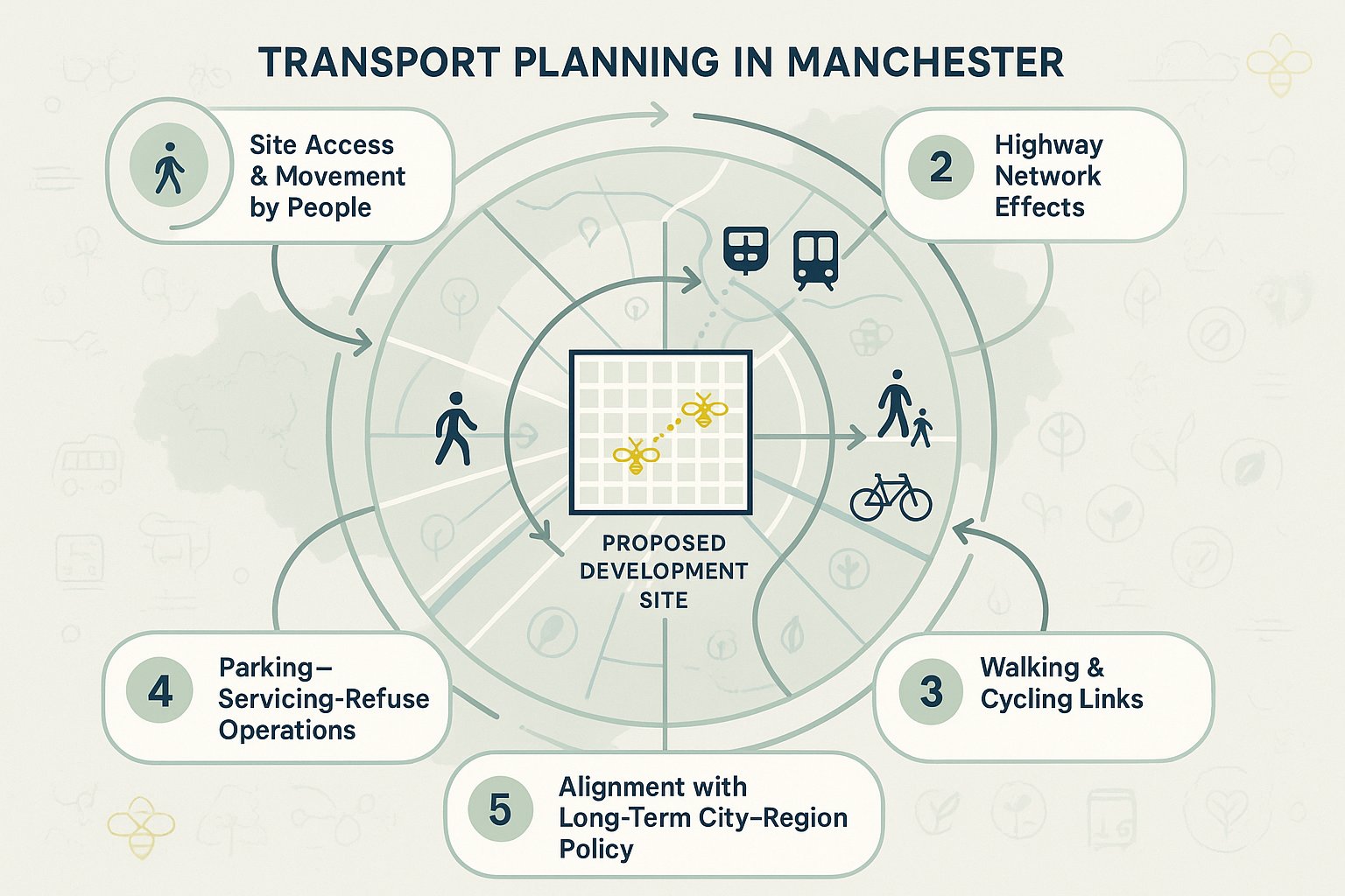
In Manchester, transport planning usually needs to address several overlapping questions:
- How will people get to and from the site?
- What effect will the scheme have on the highway network?
- Does the layout support walking, cycling and public transport use?
- Are parking, servicing and refuse movements workable and safe?
- Does the proposal support Greater Manchester’s long-term transport priorities?
That last point matters more than ever. The city-region’s transport agenda is shaped by the Bee Network and the wider Greater Manchester Transport Strategy 2040, with continuing emphasis on integrated public transport, active travel, carbon reduction and accessible growth. So a planning submission is rarely judged only on whether peak-hour traffic is severe. Decision-makers increasingly want to know whether a site is genuinely sustainable in transport terms.
For us, good transport planning Manchester work means joining up land use, movement and policy from day one. It should help shape a scheme, not just defend it after the design is fixed. On the strongest projects, the transport evidence informs access design, parking levels, servicing arrangements, cycle provision, route connections and Travel Plan measures well before submission.
When A Development In Manchester Is Likely To Need Transport Planning Input
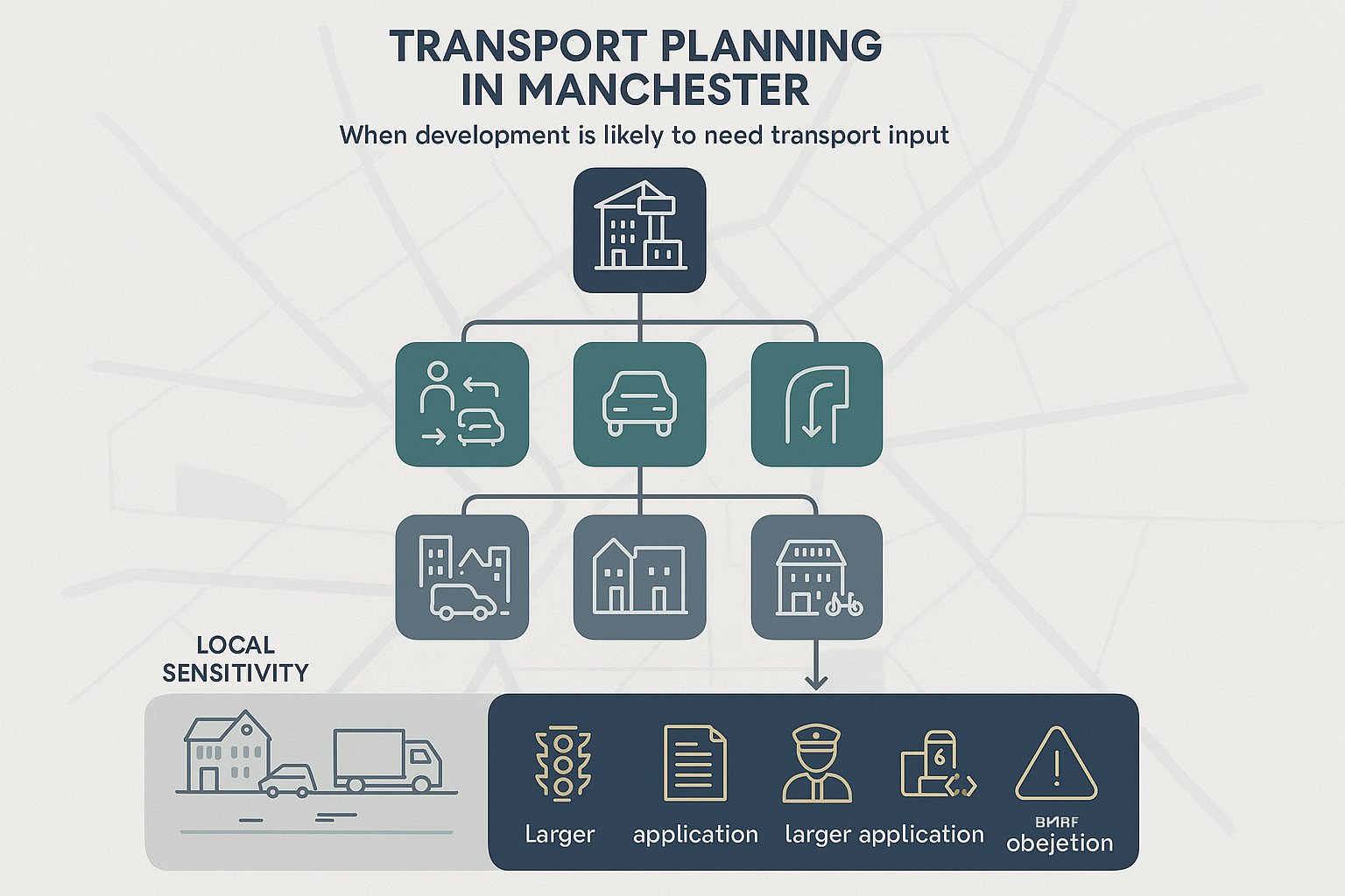
Not every application needs a lengthy technical package, but many more schemes need transport input than applicants first assume. In Manchester, the trigger is usually not one single threshold. It is the likely transport effect of the proposal and the degree to which transport issues could influence planning acceptability.
Typically, transport planning input is needed where development:
- generates notable person trips or vehicle trips:
- creates or changes access to the adopted highway:
- introduces servicing, delivery or refuse arrangements that need testing:
- affects parking provision or layout:
- sits on a constrained urban site with nearby junction or safety issues:
- forms part of a major residential, mixed-use, student, education, industrial or employment proposal:
- relies on sustainable travel credentials to support planning policy compliance.
Even relatively modest schemes can require a proportionate Transport Statement if there are local sensitivities, say, a school near a busy urban corridor, a warehouse intensification with added HGVs, or a town-centre conversion where cycle parking and servicing are tightly constrained.
And for larger applications, early transport planning is rarely optional. If the proposal needs junction modelling, formal scoping, Travel Plan commitments, access drawings or negotiations with the highway authority or Transport for Greater Manchester (TfGM), leaving transport work too late creates risk very quickly.
From our side, one of the most useful early questions is not “Do we need a TA?” but “Which transport issues could realistically become reasons for delay, objection or condition?” That framing usually leads to better decisions, faster.
Typical Reports Required For Manchester Planning Applications

The report package for a Manchester planning application depends on the scale, use, location and sensitivity of the site. Some submissions only need a concise transport note. Others need a fuller suite of assessments and drawings. The key is proportionality, enough evidence to satisfy policy and technical scrutiny, without burying the application in unnecessary paperwork.
At a broad level, the most common documents include:
- Transport Assessment (TA) or Transport Statement (TS):
- Framework Travel Plan or Full Travel Plan:
- access feasibility or highway design drawings:
- delivery and servicing strategy:
- swept path analysis, where relevant:
- junction modelling notes or other technical appendices:
- parking, cycle parking or accessibility notes where specific issues need justification.
The exact mix will vary. A city-centre office scheme might focus heavily on accessibility, parking restraint and Travel Plan measures. An edge-of-settlement industrial development may need more detailed junction testing, HGV routing and servicing evidence.
What matters is that the reports speak to one another. Too often, we see a TA saying one thing, the site layout implying another, and the servicing note quietly introducing a third assumption. Manchester applications are stronger when the transport narrative is coherent: the forecast demand, access geometry, parking levels, active travel provision and policy case all point in the same direction.
Transport Assessments And Transport Statements
A Transport Assessment is the more detailed option and is generally used for larger or more transport-sensitive proposals. It typically covers existing conditions, trip generation, trip distribution, assignment, accessibility by non-car modes, highway safety, parking, servicing, and the operational effect on surrounding roads or junctions. Where needed, it will include modelling for opening year and future year scenarios, plus mitigation.
A Transport Statement is shorter and more proportionate. It is still a technical planning document, not a light-touch letter, but it is usually suitable for smaller developments where impacts are limited and can be explained without extensive modelling.
The distinction is not just length. A TS should still address access, safety, policy and multimodal movement clearly. If the site has awkward visibility, constrained servicing, or poor pedestrian connectivity, those matters do not disappear because the scheme is smaller.
In Manchester, the decision between TA and TS should be agreed through early scoping wherever possible. That saves a lot of back-and-forth later.
Travel Plans, Delivery Strategies, And Supporting Technical Notes
Travel Plans are now a standard expectation on many developments across Greater Manchester, particularly where mode shift is part of the planning case. A good Travel Plan is not a box-ticking appendix. It sets out practical measures to encourage walking, cycling, bus, tram, rail, car sharing and smarter travel behaviour, alongside targets, management arrangements and monitoring.
For Manchester schemes, that means linking the site to Bee Network ambitions and real travel choices. If the nearest tram stop is ten minutes away, the document should explain how that route works in practice. If cycle use is being promoted, the design needs secure, convenient cycle parking and decent connections.
Delivery and servicing strategies are equally important, especially on constrained urban plots. These documents explain how goods, refuse and maintenance activity will be handled safely and efficiently, including routing, hours, turning, loading locations and on-site management.
Supporting technical notes then deal with site-specific issues, junction modelling, parking justification, swept path testing, construction access, or sensitivity checks. These shorter notes often make the difference between a submission that feels generic and one that feels thought through.
How Local Policy And Greater Manchester Transport Priorities Shape Applications
Manchester planning applications do not sit in a vacuum. Transport evidence is expected to show a clear understanding of both local development policy and city-region transport strategy. In practical terms, that means applicants must do more than show that vehicles can enter and leave the site. They need to demonstrate that the proposal contributes, or at least does not conflict with, Greater Manchester’s broader direction of travel.
That direction is well established: more trips by walking, cycling and public transport: better integrated networks: reduced carbon emissions: healthier streets: and development in locations where people are less dependent on private cars. The Bee Network has made those priorities more visible and more tangible. It is no longer enough to mention sustainable transport in passing. Decision-makers increasingly expect the site layout, access strategy and mitigation package to reflect it.
Local plan policies, parking standards, accessibility requirements and design guidance all feed into this. So do corridor studies, active travel priorities, bus improvement measures and public transport investment plans. For some sites, especially around strategic growth areas, district centres, major routes or public transport nodes, those policy layers can shape the entire transport response.
This is why policy-led transport planning matters. If the evidence is framed only around highway capacity, it can feel out of step with how Manchester now assesses growth. A stronger approach is to show how the proposal supports compact, accessible development: realistic walking links, good cycle provision, sensible parking levels, clear servicing, and a credible strategy for reducing unnecessary car trips. That tends to land much better with officers, consultees and committees alike.
Key Issues That Commonly Affect Site Promotion And Planning Consent
The transport issues that influence planning outcomes in Manchester are often predictable, but they still catch teams out. In our experience, the most contentious matters are rarely hidden technical oddities. They are usually the basics done poorly, or done too late.
At site promotion stage, transport can affect whether land is seen as genuinely deliverable. A location may look attractive on paper but struggle once access geometry, junction operation, bus accessibility, walking routes, parking restraint or servicing constraints are tested. By the time an application is live, those same points can become formal objections, holding comments or onerous conditions.
The key questions usually include:
- can safe and suitable access be achieved?
- will the local network operate acceptably?
- does the scheme fit policy on sustainable movement?
- are parking and servicing realistic on the site?
- is there a credible case for mode shift?
Manchester is especially sensitive to the balance between growth and movement. Some proposals fail because they overpromise sustainable travel while providing a car-dominant layout. Others fail because they focus so narrowly on traffic impact that they ignore active travel and public transport altogether.
Good site promotion and planning strategy deal with both. We need robust technical evidence, yes, but also a transport narrative that makes sense in planning terms.
Access Design, Highway Safety, And Junction Capacity
Access design is often the first hard test. Can vehicles enter, exit and manoeuvre safely? Are visibility splays compliant? Is the geometry suitable for the intended users, including larger service or refuse vehicles? Does the arrangement work for pedestrians and cyclists, not just drivers?
In Manchester, constrained urban frontages are common, so these questions matter. A scheme with weak access detail can lose credibility fast, even if the land use principle is acceptable.
Highway safety is another recurring issue. Existing collision patterns, awkward turning movements, school pick-up conflicts, or poor pedestrian crossing conditions can all trigger requests for further work. Safety does not have to be a showstopper, but it does need honest analysis and, where necessary, mitigation.
Then there is junction capacity. For major schemes, modelling may be needed to assess operation in the opening year and a future assessment year, often with committed development in the background. The goal is not always to eliminate all delay, that is unrealistic in urban Manchester, but to demonstrate that impacts are understood, proportionate and manageable.
Mitigation might include access amendments, signal optimisation, localised highway works, travel demand measures, or staged delivery. But the modelling has to be transparent and based on defensible assumptions. If not, expect questions.
Parking, Servicing, Active Travel, And Public Transport Connectivity
Parking can be one of the most politically sensitive elements of an application. Too much parking can undermine a site’s sustainability case. Too little, badly justified, can spark concern about overspill and operational failure. In Manchester, that balance often depends on context: city centre, district centre, suburban edge, employment area, student catchment, it all matters.
Cycle parking is no longer a token afterthought either. The quality, quantity, security and convenience of cycle provision can influence whether a site’s active travel claims are taken seriously.
Servicing is equally important. We often see layouts where servicing technically fits on a drawing but would be awkward in real operation. Delivery bays blocked by parked cars, refuse vehicles reversing excessively, or on-street loading assumptions with no practical management plan, these issues can derail progress.
Public transport connectivity also carries weight. Applicants should understand not just the presence of bus, Metrolink or rail services, but the quality of access to them. Is the route direct? Is it safe at night? Does it involve hostile crossings? Those details affect whether mode shift assumptions feel credible.
The best Manchester schemes treat parking, servicing, active travel and public transport as one joined-up movement strategy, not four separate checklist items.
The Transport Planning Process From Early Appraisal To Decision
A strong transport planning process starts before the application pack is assembled. By the time a layout is fixed and the planning statement is drafted, options are already narrowing. That is why early appraisal is so valuable.
Stage one is usually a high-level review of the site and proposal: existing access conditions, surrounding highway constraints, nearby public transport, active travel links, local collision history, policy context, likely trip intensity and whether formal transport submissions are likely to be needed.
Stage two is scoping. This often involves discussion with the local highway authority, and where relevant TfGM, on the likely scope of assessment, data requirements, study area, junctions to test, modelling expectations, Travel Plan needs and any site-specific concerns. A good scoping note can save weeks.
Next comes data collection and analysis. That may include traffic counts, queue observations, speed surveys, parking beat surveys, accessibility mapping, TRICS-informed trip generation, census data review, servicing demand estimates and accident data analysis. Larger schemes may require junction modelling and sensitivity testing.
Then comes reporting and design iteration. This is the stage where the transport evidence should influence the scheme, not simply document it. Access geometry might change. Cycle parking may be improved. Servicing routes may be redesigned. Parking levels may be refined. Travel Plan measures may become more specific.
Finally, the application moves to determination, where transport consultees review the evidence and negotiations may continue around conditions, obligations, off-site works, Travel Plan monitoring or phasing. If the groundwork has been done properly, this stage is usually far smoother. If not, it can become a scramble of late technical notes and revisions.
How To Prepare A Strong Evidence Base For Manchester Sites
A strong evidence base is not just a large appendix pack. It is a set of transport documents that are current, proportionate, locally relevant and internally consistent. In Manchester, where policy expectations are evolving and site contexts can be highly urban and constrained, weak evidence is spotted quickly.
The first ingredient is good data. Traffic counts should be recent enough to reflect current conditions and suitable for the type of assessment being undertaken. Accessibility analysis should look at real travel opportunities, not generic assumptions. Parking and servicing evidence should reflect how the area actually operates.
The second is robust forecasting. Trip generation, distribution and assignment need to be transparent and sensible. If assumptions are optimistic, they should be tested. If mode share claims are ambitious, they need to be backed by site context, design quality and Travel Plan measures.
The third is policy alignment. The submission should clearly explain how the development responds to local planning policy, parking standards, accessibility expectations and Greater Manchester priorities around mode shift, carbon reduction and integrated transport. That does not mean quoting policy at length. It means showing its practical effect on the scheme.
The fourth is clarity. Officers and consultees should be able to follow the logic. Why were certain junctions tested? Why is the parking level appropriate? How will servicing work? What mitigation is proposed and why?
This is also where experienced, locally aware reporting makes a difference. At ML Traffic, for example, the focus is on concise, accurate transport engineering reports tailored to local authority thresholds and planning contexts. That kind of proportionality matters. Long reports do not automatically make strong reports.
For Manchester sites, the best evidence base usually combines technical rigour with plain speaking. It anticipates the obvious questions before they are asked.
Common Mistakes That Delay Transport Planning Submissions
Most transport delays are avoidable. They happen because important questions were left too late, assumptions were not tested, or the submission treated transport as a compliance exercise rather than a live planning issue.
One common mistake is poor early scoping. If the local highway authority or TfGM would clearly expect a TA, junction modelling, or a Travel Plan, it is better to establish that early than argue about it after validation. Ambiguity rarely speeds things up.
Another is using weak or outdated data. Old counts, limited survey days, or borrowed assumptions from unrelated sites can undermine an otherwise solid application. Reviewers notice.
A third is design and report mismatch. We have all seen it: the TA assumes service vehicles can turn on site, but the drawing does not show it convincingly: the Travel Plan promises active travel, but cycle parking is hidden in a corner behind bins: the parking note justifies restraint, but the layout still prioritises car access over pedestrian movement. Those inconsistencies invite challenge.
There is also the persistent problem of focusing only on cars. Manchester applications are expected to address walking, cycling, bus, tram and rail connectivity where relevant. A highway-only mindset can make a submission feel dated and out of step with policy.
Other frequent issues include:
- non-compliance with local parking standards without a credible justification:
- unrealistic servicing assumptions:
- lack of sensitivity testing in capacity work:
- overlooking construction access and temporary impacts:
- presenting generic Travel Plans with little site-specific substance.
The fix is usually simple, though not always easy: start earlier, scope properly, use current evidence, and let the transport work influence design while change is still possible.
Conclusion
Transport planning in Manchester has become more exacting, but also more useful. Done well, it does not just satisfy a planning requirement: it helps shape better development, safer access, cleaner servicing, more realistic parking, stronger active travel links, and a clearer fit with Greater Manchester’s long-term movement strategy.
For project teams, the practical lesson is straightforward. Start early. Scope properly. Build the evidence around the actual site, not a template. And make sure the transport story reflects how Manchester now evaluates growth: through accessibility, mode shift, network performance and placemaking together.
That is the difference between a submission that merely answers transport questions and one that moves the planning process forward. In our experience, the strongest transport planning Manchester submissions are policy-led, technically robust and proportionate to the scheme. They give decision-makers confidence, and that, more than anything, is what keeps applications moving.
Transport Planning in Manchester: Frequently Asked Questions
What does transport planning in Manchester involve?
Transport planning in Manchester assesses how a development interacts with the transport network and ensures alignment with Greater Manchester’s Transport Strategy 2040/2050 and local policies, focusing on access, active travel, public transport integration, and reduced car dependence.
When is transport planning input required for a Manchester development?
Transport planning input is typically needed when a development generates significant trips, alters highway access or parking, involves major residential, mixed-use or employment schemes, or relies on sustainable travel credentials to meet planning policy.
What types of transport reports are commonly required for Manchester planning applications?
Common reports include a Transport Assessment or Transport Statement, Framework or Full Travel Plan, access and highway design drawings, delivery and servicing strategies, and technical notes such as junction modelling or parking justification, scaled to the development size and complexity.
How does the Bee Network influence transport planning assessments in Manchester?
The Bee Network shapes transport planning by promoting integrated walking, cycling, and public transport connections, supporting compact, accessible development and mode shift away from private cars, which developments must demonstrate alignment with in their transport submissions.
What are common mistakes that delay transport planning approvals in Manchester?
Delays often stem from inadequate early scoping with TfGM or highway authorities, outdated or weak data, ignoring active travel and public transport, non-compliance with parking standards, and inconsistent design and reporting, all of which can undermine a planning submission.
How should a strong transport evidence base be prepared for Manchester planning applications?
A strong evidence base uses up-to-date traffic and multimodal data, robust trip generation and distribution assumptions, clear links to Greater Manchester’s 2040/2050 strategy and Bee Network priorities, transparent modelling with sensitivity tests, and coherent integration of design and policy.