Planning applications in Nottingham rarely succeed on design alone. If a scheme changes how people arrive, leave, park, service, cross the street, catch a bus, reach the tram, or affect a nearby junction, transport evidence quickly moves from “supporting document” to a central planning issue. And in 2026, that matters even more.
Transport planning in Nottingham sits at the meeting point of national policy, local validation requirements, regeneration priorities, and the day-to-day realities of a busy urban network. The city has long pushed for an integrated approach built around sustainable travel: buses, NET tram, rail, walking and cycling, with highway capacity considered in that wider picture rather than in isolation. That means developers can’t rely on a generic report lifted from another authority area and hope it lands well here.
We’ve seen the difference a properly scoped, locally informed submission makes. Strong transport work can reduce objections, focus negotiations, and help planning officers and highway officers reach a view faster. Weak work does the opposite: extra questions, delayed decisions, expensive redesigns, and sometimes avoidable refusals.
In this guide, we set out what developers, architects, planners, lawyers and consultants need to know about transport planning in Nottingham: when evidence is likely to be needed, which documents matter, the local issues that shape decisions, and where applications most often run into trouble. The aim is simple, smoother planning applications, with fewer surprises.
What Transport Planning Means In The Nottingham Planning Context
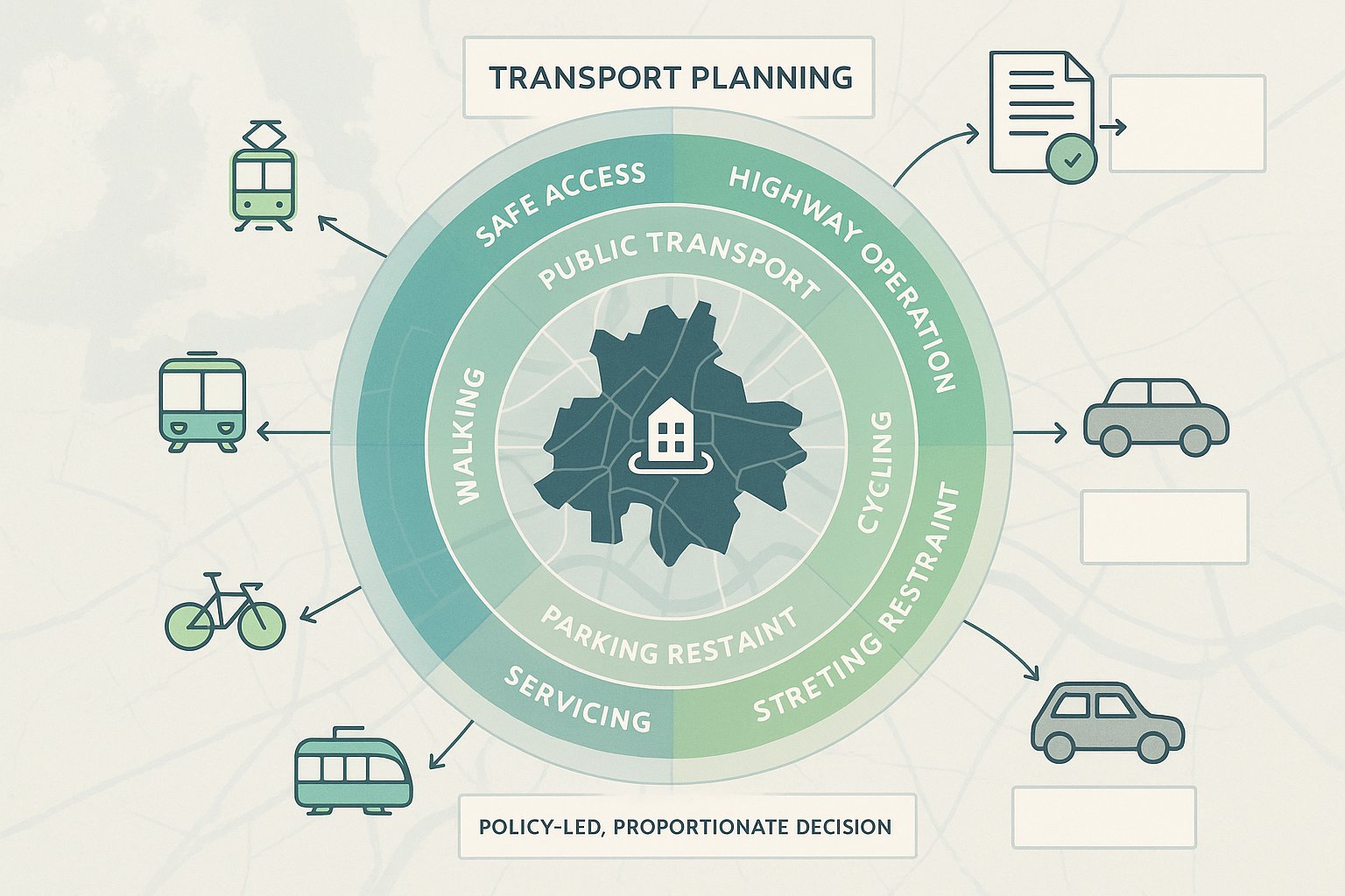
Transport planning in Nottingham is not just about measuring traffic queues outside a site. In practice, it is the process of showing that a development can be accessed safely, function effectively, and support the transport priorities set by national and local policy.
At the top level, the National Planning Policy Framework expects developments to provide safe and suitable access for all users and to assess transport impacts where they are likely to be significant. Locally, that sits alongside the transport strategies of Nottingham City Council, Nottinghamshire County Council, and the wider Greater Nottingham planning area. Together, those frameworks push in a clear direction: reduce unnecessary car dependence, support growth in the right places, and make better use of public transport, walking and cycling infrastructure.
That local context matters. Nottingham is not an authority area where a purely car-led argument usually feels comfortable, especially for central or well-connected sites. The presence of the NET tram, strong bus corridors, rail links, regeneration zones and long-standing policy support for mode shift means transport planners need to think in layers. Yes, highway operation still matters. But so do accessibility, sustainable travel opportunities, parking restraint, servicing practicality, and street design.
For developers, the key point is this: transport planning here is most persuasive when it is policy-led and proportionate. We need to show not only what trips a scheme may generate, but also how the site fits into Nottingham’s wider transport objectives and whether the proposal has been designed to align with them.
When A Development In Nottingham Is Likely To Need Transport Evidence
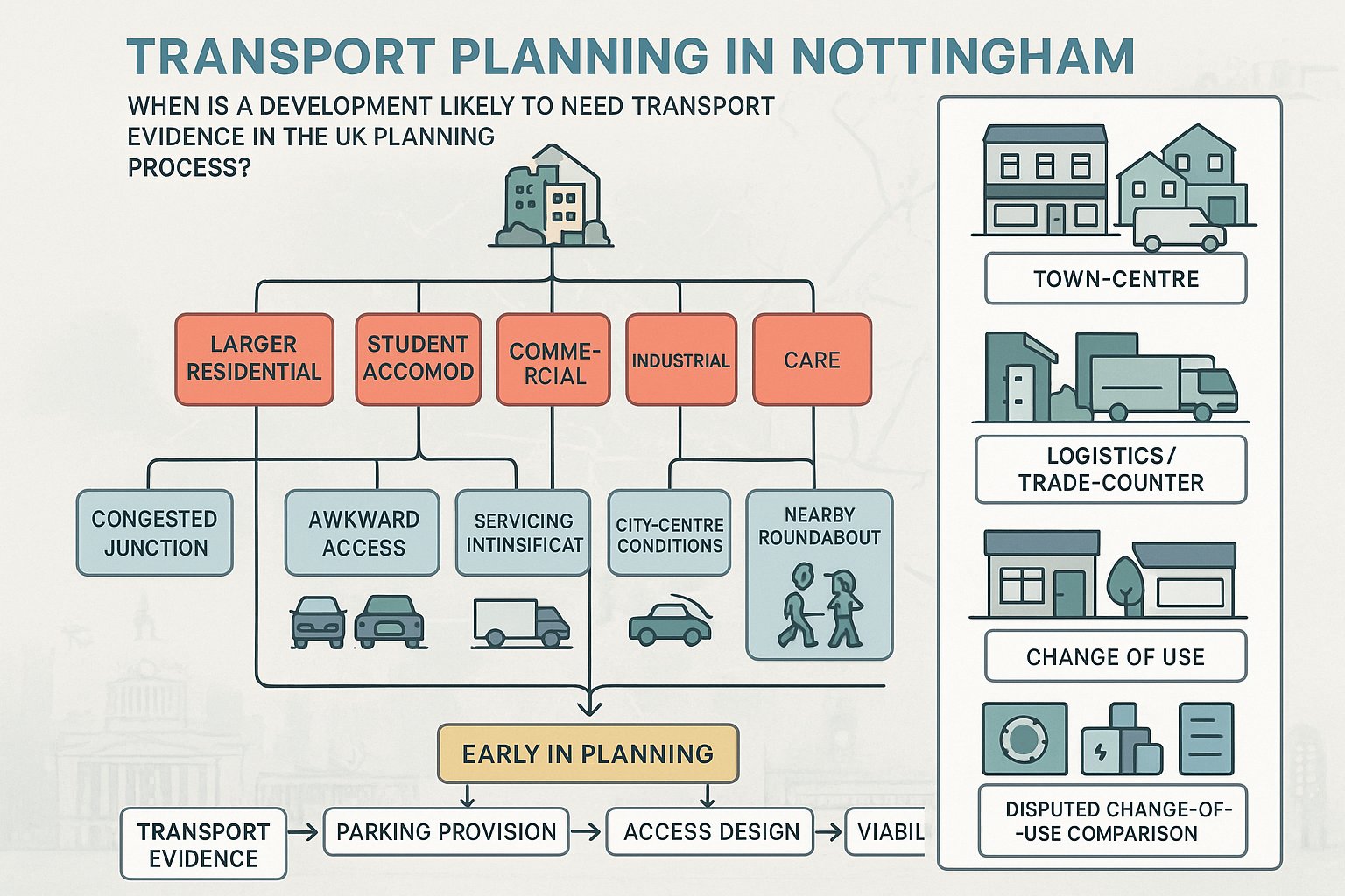
Not every planning application in Nottingham needs a full transport package. But many more schemes need some level of transport evidence than applicants initially assume.
The trigger is usually whether the development has significant transport implications, in line with the NPPF and local validation expectations. That often includes larger residential schemes, student accommodation, commercial development, industrial sites, care uses, mixed-use proposals, and applications on constrained or sensitive sites. Even modest schemes can need evidence if they sit near a congested junction, involve awkward access arrangements, alter parking supply, intensify servicing, or are located in a busy district or city-centre environment.
A few practical examples make this clearer:
- A town-centre scheme with limited parking may need evidence on public transport accessibility and servicing even if traffic generation is relatively low.
- A suburban redevelopment may trigger assessment because of turning movements at a nearby roundabout or school-time pressure on the road network.
- A logistics or trade-counter use may need detailed servicing and swept path analysis because vehicle type matters as much as trip numbers.
- A change of use can still require transport evidence where the comparison between lawful existing use and proposed use is contested.
In Nottingham, we generally advise developers to ask the question early rather than late. If transport evidence is needed, the scope can affect site layout, parking provision, access design, and viability assumptions. Waiting until validation stage to think about transport is where many programmes start slipping.
Common Transport Planning Documents Required For Planning Applications
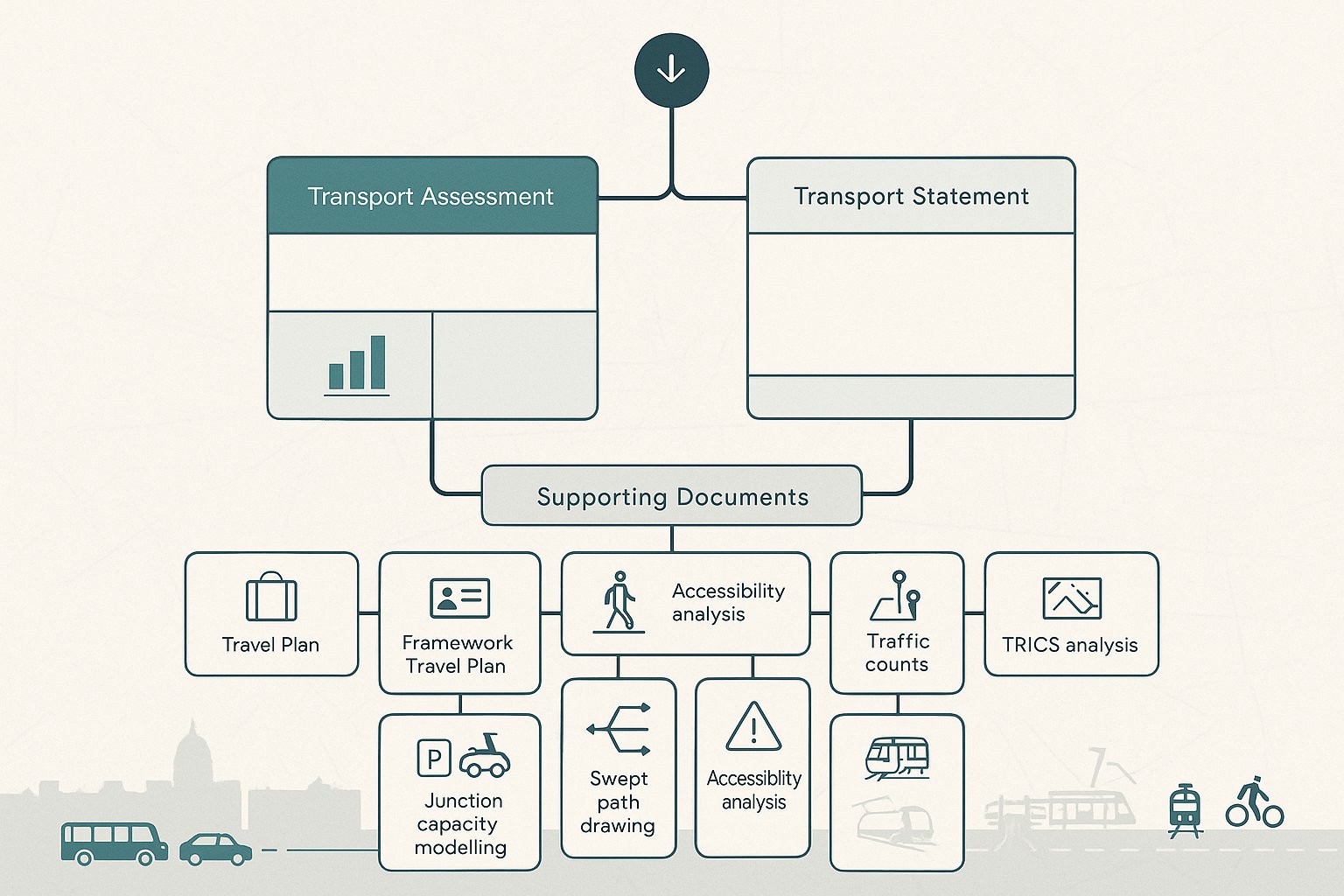
The documents needed for a Nottingham planning application depend on scale, location, and likely impact, but there is a familiar core set that appears again and again.
Most commonly, applications require either a Transport Assessment (TA) or a Transport Statement (TS). Depending on the scheme, those may be supported by a Travel Plan or Framework Travel Plan, technical notes on specific issues, junction capacity modelling, parking and servicing information, swept path drawings, accessibility analysis, and sometimes Road Safety Audit input where off-site highway works are proposed.
The strongest submissions are not the longest ones. They are the ones that answer the right questions, with the right evidence, in a form the local authority can follow. That sounds obvious, but it’s where many reports go wrong. An overblown document can obscure the key points. A thin report can leave highway officers filling in the gaps themselves, and they rarely do that in the applicant’s favour.
At ML Traffic, our approach is to tailor evidence to local thresholds and planning context rather than default to a standard template. Nottingham schemes often need a balanced package: enough technical detail to withstand scrutiny, but proportionate to what the authority actually needs to make a decision.
Transport Assessment Vs Transport Statement
A Transport Assessment is the fuller, more detailed document. It is usually appropriate where a development is expected to generate significant trips, affect peak-hour network operation, interact with sensitive junctions, or create notable impacts on public transport, walking, cycling, parking or servicing. A TA typically includes baseline conditions, accessibility review, trip generation, distribution and assignment, capacity testing, road safety review, and mitigation if needed.
A Transport Statement is lighter touch. It is still a technical planning document, but proportionate to schemes where impacts are expected to be limited. A TS may cover site access, local transport conditions, parking, sustainable travel options, and a reasoned case that transport effects are acceptable without extensive modelling.
The distinction matters because the wrong level of reporting can create avoidable friction. Submit a TS where a TA is clearly needed and you invite objections. Submit a TA for a minor low-impact scheme and you may spend money solving a problem nobody asked.
Travel Plans, Technical Notes, And Supporting Evidence
A Travel Plan explains how a development will encourage sustainable travel once built and occupied. In Nottingham, that usually means practical measures to increase walking, cycling, bus, tram and rail use, while reducing unnecessary single-occupancy car trips. Good Travel Plans include realistic targets, site-specific measures, management responsibility, monitoring, and review mechanisms. Weak ones read like generic wish lists.
Technical notes are often just as important as the headline report. A short note can deal with a specific issue such as a single junction, internal servicing, refuse collection strategy, car parking stress, cycle parking provision, or the transport effects of a design revision. These can be invaluable during determination, especially when consultation responses raise a focused concern.
Supporting evidence typically includes:
- traffic counts and queue observations
- TRICS trip rate analysis
- accessibility mapping for bus, tram, rail, walking and cycling
- parking accumulation or beat surveys
- collision data and road safety review
- junction capacity modelling
- swept path and tracking drawings for service vehicles
In other words, transport planning in Nottingham is rarely one PDF and done. It is usually a suite of coordinated evidence.
Key Nottingham Transport And Highways Issues That Shape Planning Decisions
Nottingham has a distinctive transport character, and planning decisions reflect it. The city and wider area are shaped by long-standing investment in integrated transport, strong policy support for regeneration, and a practical need to manage congestion, air quality and network resilience.
For applicants, that means transport submissions are usually judged through two lenses at once. First: does the scheme work technically? Second: does it support the direction of travel set by local policy? A proposal that technically “fits” but leans heavily on private car use in a highly accessible location may still attract challenge.
The local transport plans for the city and county, together with wider strategic planning across Greater Nottingham, consistently prioritise mode shift, better public transport use, active travel, and transport networks that support sustainable growth. So when highway and planning officers review an application, they are not just checking visibility splays or turning radii. They are also asking whether the development has been planned in a way that makes sustainable travel a credible first choice.
This is especially relevant in locations tied to regeneration objectives or where cumulative growth is already placing pressure on the network. In those cases, even seemingly ordinary topics, parking levels, servicing hours, pedestrian routes, crossing points, cycle storage, bus stop access, can carry more weight than applicants expect.
City Centre, Regeneration Areas, And Public Transport Accessibility
In Nottingham city centre and major regeneration areas, accessibility by non-car modes is often one of the defining planning issues. The combination of bus services, the NET tram, rail connections and dense walkable streets means authorities will usually expect lower reliance on private cars than they might in more peripheral or poorly connected locations.
That has several implications. Parking provision may be restrained. Travel Plans need to be more than boilerplate. Routeing to nearby stops and stations must be practical and legible. And applicants should be ready to explain why proposed occupiers would realistically choose sustainable modes.
This is not just policy theory. For central schemes, a car-dominant narrative can look out of step with the local evidence base. Where a site sits close to high-frequency public transport, the burden is often on the applicant to justify higher parking levels or assumptions that most trips will still be made by car.
Regeneration areas bring another layer. Councils often want development to reinforce broader investment in place-making and connectivity, not undermine it. So site access, frontage design, pedestrian permeability and cycle integration all become part of the transport story.
Parking, Servicing, Road Safety, And Network Capacity Considerations
Outside pure accessibility, four issues repeatedly shape outcomes in Nottingham: parking, servicing, road safety, and network capacity.
Parking is rarely just a numbers exercise. Authorities will look at whether provision is appropriate for the location, use class, likely demand profile, and sustainable travel alternatives. Under-provision can create overspill concerns: over-provision can conflict with policy aims and encourage unnecessary car use. The answer is usually evidence-led rather than ideological.
Servicing is another common flashpoint. Can delivery vehicles enter, manoeuvre and exit safely? Will loading occur on-street? Are bin stores and collection points workable? A scheme that looks fine on a site plan can fail quickly if servicing has been treated as an afterthought.
Road safety is equally important. Collision data review, visibility checks, internal layout assessment and, where required, Road Safety Audit input can all influence the authority’s view. If an access sits near a known collision cluster or difficult junction, expect questions.
Then there is capacity. Nottingham’s network contains busy corridors and sensitive junctions where small increases in traffic can become contentious, especially in peak periods. Where impacts may be material, robust modelling and clearly explained mitigation are usually essential.
How Trip Generation, Modal Split, And Junction Impact Are Typically Assessed
This is the part many teams think of first when they hear “transport planning”: how many trips will the development generate, how will people travel, and what happens at nearby junctions?
In Nottingham, trip generation is commonly assessed using TRICS-based analysis, informed by the proposed land use, scale, local context and comparable sites. But the database output is only the starting point. The real work lies in selecting appropriate sites, applying sensible filters, and explaining why the resulting rates make sense for Nottingham rather than for a generic UK average.
Existing lawful use also matters. For redevelopments and changes of use, we often compare the proposed scenario against a realistic existing-use baseline, not just a vacant-site assumption. That can materially affect the impact case.
Modal split is then considered using local evidence, often drawing on census data, local transport plan assumptions, accessibility to bus, tram and rail, walk and cycle links, and the characteristics of the likely occupier group. A city-centre apartment scheme near strong public transport is unlikely to justify the same car-driver share as an edge-of-settlement industrial site. If the assumed mode split feels disconnected from the site’s actual accessibility, officers will spot it.
Junction impact is usually tested where traffic changes could affect operation on nearby highway links or nodes. Depending on the scale and location, that may involve priority junction modelling, roundabout analysis, signal assessment, or wider strategic modelling within the Greater Nottingham context. The key is scoping: assess too little and the authority may ask for more: assess too much and you can drown the application in unnecessary technicality.
Good assessment is transparent. We show the assumptions, justify them, and explain the significance of the result in planning terms, not just model output terms.
Design And Access Considerations That Support A Strong Transport Case
A transport report can only defend the scheme that is put in front of it. If the layout is awkward, the access is unsafe, pedestrians are funnelled through a car park, cycle parking is tokenistic, or service vehicles can’t turn properly, even the best-written assessment will struggle.
That is why transport planning in Nottingham works best when it is fed into design early. We want site layouts that are walkable, permeable and inclusive, with direct routes to surrounding streets, public transport stops, and local facilities. We want access points that work for all users, not just drivers. And we want parking, servicing and cycle provision integrated into the design rather than squeezed into left-over space.
A few design points regularly strengthen the planning case:
- clear pedestrian desire lines from the site to nearby streets and crossings
- safe, convenient cycle parking in suitable quantities and locations
- access geometry that accommodates the right vehicles without over-engineering the frontage
- inclusive routes for wheelchair users and people with limited mobility
- internal layouts that reduce conflict between cars, service vehicles, cyclists and pedestrians
- realistic refuse and delivery arrangements
- legible links to bus stops, tram stops or stations
These issues matter because they bridge policy and lived reality. A report can claim a scheme supports sustainable travel, but if residents or staff have to navigate a hostile route to reach the nearest stop, that claim won’t carry much weight.
For architects and developers, this is often the most cost-effective lesson of all: small design decisions made early can prevent major transport objections later.
Working With Nottingham City Council, Nottinghamshire County Council, And Highway Stakeholders
One of the most practical parts of successful transport planning is knowing who needs to be engaged, and when.
Within the city boundary, Nottingham City Council acts as local highway authority. Elsewhere, Nottinghamshire County Council will often be the relevant highway authority. For some schemes, especially those touching strategic corridors, rail interfaces, tram operations, or wider public transport interests, other stakeholders may also need to be involved, including transport operators, Network Rail, or regional transport bodies.
This matters because each authority area has its own local pressures, consultation style and evidential preferences. The fundamentals may be similar, but the emphasis can shift depending on whether the site is in a dense urban location, a regeneration corridor, a market town, or a county-edge growth area.
Early engagement usually pays for itself. A well-scoped pre-application discussion can clarify:
- whether a TA or TS is expected
- which junctions should be assessed
- whether a Travel Plan is required
- what level of parking and servicing detail is needed
- whether road safety concerns are likely to be central
- if any local datasets or strategic modelling assumptions should be used
Without that conversation, applicants can end up producing evidence that is technically competent but procedurally misaligned.
We also find that collaborative engagement works best when it is candid. If there is a difficult junction, a constrained access, or a likely policy tension, it is usually better to put it on the table early and work through it than hope it slips past consultation. In Nottingham, highway stakeholders tend to respond well to applicants who understand the local context and come prepared with evidence, options and a realistic attitude.
Common Reasons Transport Planning Submissions Are Delayed Or Challenged
Most transport-related delays are not caused by genuinely impossible highway problems. They are caused by avoidable weaknesses in scope, evidence, or coordination.
The first common issue is poor scoping. A report may assess the wrong study area, omit a sensitive junction, or choose a TS where a TA was obviously needed. Once consultation responses land, the applicant then has to backfill missing work under time pressure.
Second, some submissions under-estimate trip generation or rely on optimistic assumptions without enough justification. That is especially risky in Nottingham locations where congestion, school traffic, constrained parking, or cumulative development effects are already live concerns. If the numbers feel engineered to reach a convenient conclusion, confidence drops quickly.
Third, Travel Plans are often weak. Authorities can usually tell the difference between a credible behaviour-change strategy and a generic appendix copied between projects. If targets are vague, measures are uncosted, responsibilities are unclear, or monitoring is absent, expect challenge.
Fourth, parking and servicing are regularly undercooked. A site may technically fit the use, but if vans cannot turn, loading blocks circulation, refuse collection is unclear, or overspill parking risk has not been addressed, those operational issues can derail progress.
Fifth, some applications lack enough safety or modelling evidence. Missing collision analysis, absent swept paths, limited accessibility review, or incomplete junction testing all create openings for objection.
And finally, there is simple coordination failure. When the transport case, site layout, Design and Access Statement, and planning narrative do not align, decision-makers notice. A smoother application usually comes from one integrated story, not a pile of disconnected reports.
Conclusion
For developers, consultants and project teams, the main lesson is straightforward: transport planning in Nottingham needs to be locally grounded, evidence-led and designed in from the start.
The schemes that move more smoothly through planning are usually the ones that recognise Nottingham’s policy direction early, support for sustainable travel, careful treatment of parking and servicing, safe access for all users, and a realistic understanding of network impacts. They also tend to involve early discussion with the relevant highway authority, proportionate technical work, and layouts that genuinely support the transport case rather than fight against it.
In our experience, that is where time is saved. Not by producing the biggest report, but by producing the right one.
If you are preparing a scheme in the city or wider Greater Nottingham area, it is worth scoping transport requirements before the application package is fixed. That early step can reduce redesign, avoid late technical disputes, and give planners and highway officers a clearer route to yes.
Transport Planning in Nottingham: Frequently Asked Questions
What is transport planning in Nottingham and why is it important for developments?
Transport planning in Nottingham involves demonstrating that a development is safely accessible, supports sustainable travel modes like walking, cycling, public transport, and aligns with local and national policies to manage congestion and support urban regeneration.
When is transport evidence required for a planning application in Nottingham?
Transport evidence is needed when a development has significant transport impacts, such as large residential or commercial schemes, changes near sensitive junctions, alterations to parking or servicing, or when located in busy or regeneration areas, as per NPPF and local validation standards.
What are the differences between a Transport Assessment (TA) and a Transport Statement (TS) in Nottingham planning applications?
A Transport Assessment (TA) is a detailed report for developments generating significant trips impacting peak hours or public transport, while a Transport Statement (TS) is a lighter, proportionate document for smaller schemes with limited transport effects.
How do Nottingham’s local transport policies influence planning applications regarding parking and servicing?
Local policies prioritise sustainable travel; therefore, parking must be evidence-led—neither too high, encouraging car use, nor too low causing overspill. Servicing arrangements must be safe, practical, and well-integrated into design to meet highway authority expectations.
Why should developers engage early with Nottingham City Council or Nottinghamshire County Council about transport planning?
Early engagement helps clarify transport evidence requirements, scope of assessments, parking and servicing standards, and local concerns, preventing delays, ensuring aligned submissions, and facilitating smoother, faster planning decisions.
How is trip generation and modal split assessed for developments in Nottingham?
Trip generation uses TRICS-based data tailored to local context and existing use comparisons. Modal split considers local census and transport plan data, accessibility to tram, bus, and rail, and likely occupier profiles to reflect realistic travel mode choices.