Wakefield is not a place where transport can be treated as a planning afterthought. Between housing growth, employment allocations, pressure on strategic routes, town-centre regeneration, school travel demand and the wider push toward lower-carbon movement, transport planning in Wakefield now sits right at the centre of whether an application moves smoothly or gets stuck in avoidable debate.
For architects, developers, planners, surveyors and legal teams, that matters. A scheme may look sound on land use, design and viability, yet still run into trouble if the transport evidence is thin, badly scoped or disconnected from local policy. We see this regularly: reports that rely on generic assumptions, omit the wrong junction, underplay servicing, or say very little about walking, cycling and bus access. That is usually where questions begin.
In Wakefield, the planning context combines national guidance, the Wakefield Local Plan, local validation expectations and the broader direction of the West Yorkshire Transport Strategy 2040. So the task is not simply to count vehicle trips. It is to show, clearly and credibly, how a development will function, how people will reach it, what effects it may have on the network, and what mitigation is needed.
In this guide, we set out the practical issues that usually matter most for planning applications in 2026, from deciding between a Transport Statement and a full Transport Assessment to dealing with parking, servicing, road safety and active travel expectations.
Why Transport Planning Matters In Wakefield Development
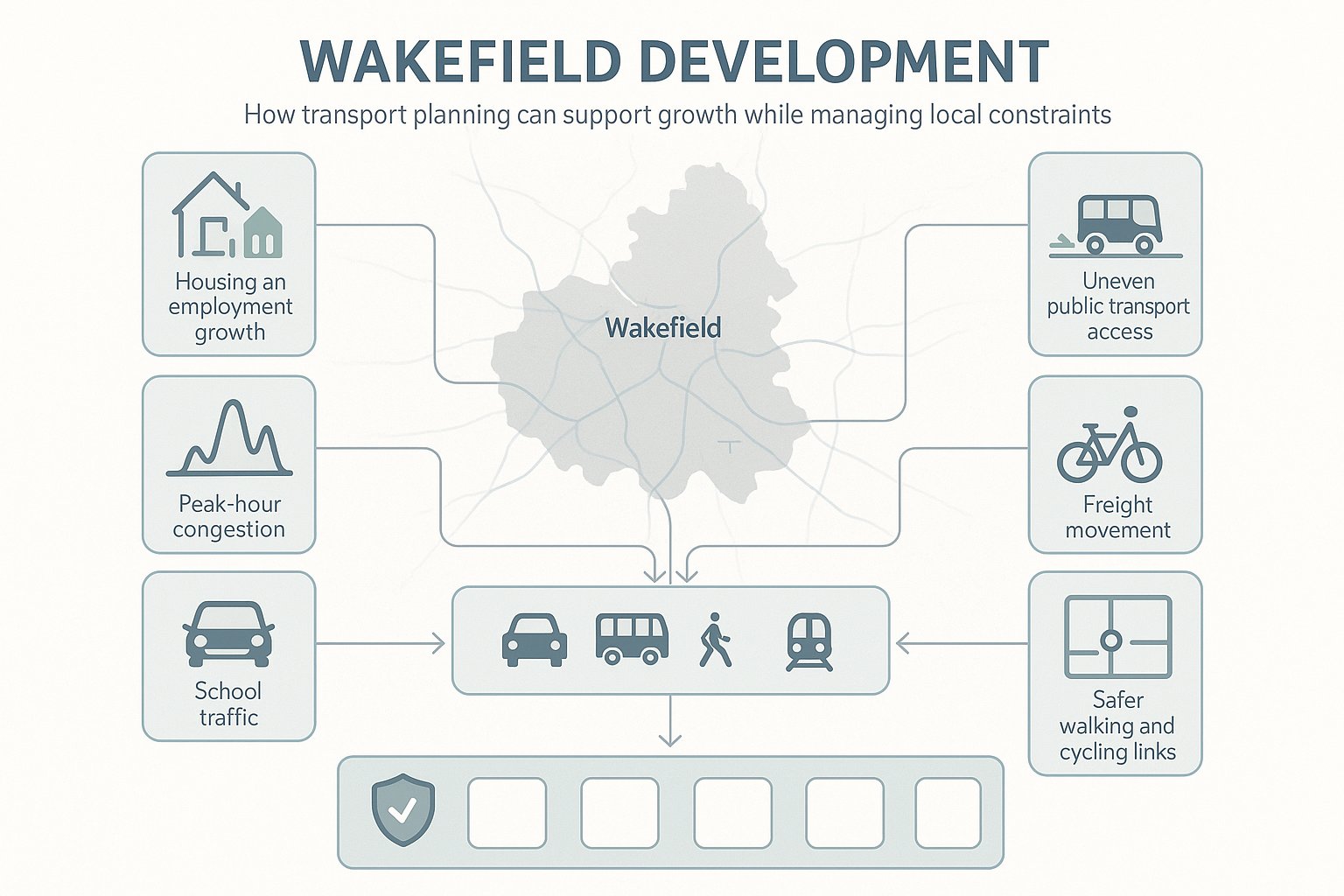
Transport planning in Wakefield plays a bigger role than many applicants first expect. It is not only about vehicle capacity at a nearby junction: it is about whether development supports the district’s growth strategy without creating unacceptable pressure on roads, streets and communities.
Wakefield continues to balance housing and employment growth across the city and the Five Towns while dealing with familiar transport constraints: peak-hour congestion, uneven public transport accessibility in some areas, school-related traffic, freight movement and the need for safer active travel connections. That means transport evidence often becomes one of the key technical strands in determining whether a proposal is acceptable in principle.
There is also a wider policy purpose. National planning policy expects development to promote sustainable transport, provide safe and suitable access, and mitigate significant impacts. Locally and regionally, the direction of travel is even clearer. West Yorkshire’s transport strategy pushes for better connectivity, lower emissions and more realistic alternatives to private car dependence. In practice, applicants need to demonstrate that schemes are not only workable for drivers, but also accessible for pedestrians, cyclists, bus users and, where relevant, rail users.
For us, the real value of good transport planning is simple: it turns risk into something manageable. A robust report can identify likely concerns early, shape the site layout, support negotiations with highways officers and reduce the chance of late redesign. On complex sites, that can save months, not just paperwork.
Wakefield Planning Context And Local Transport Considerations
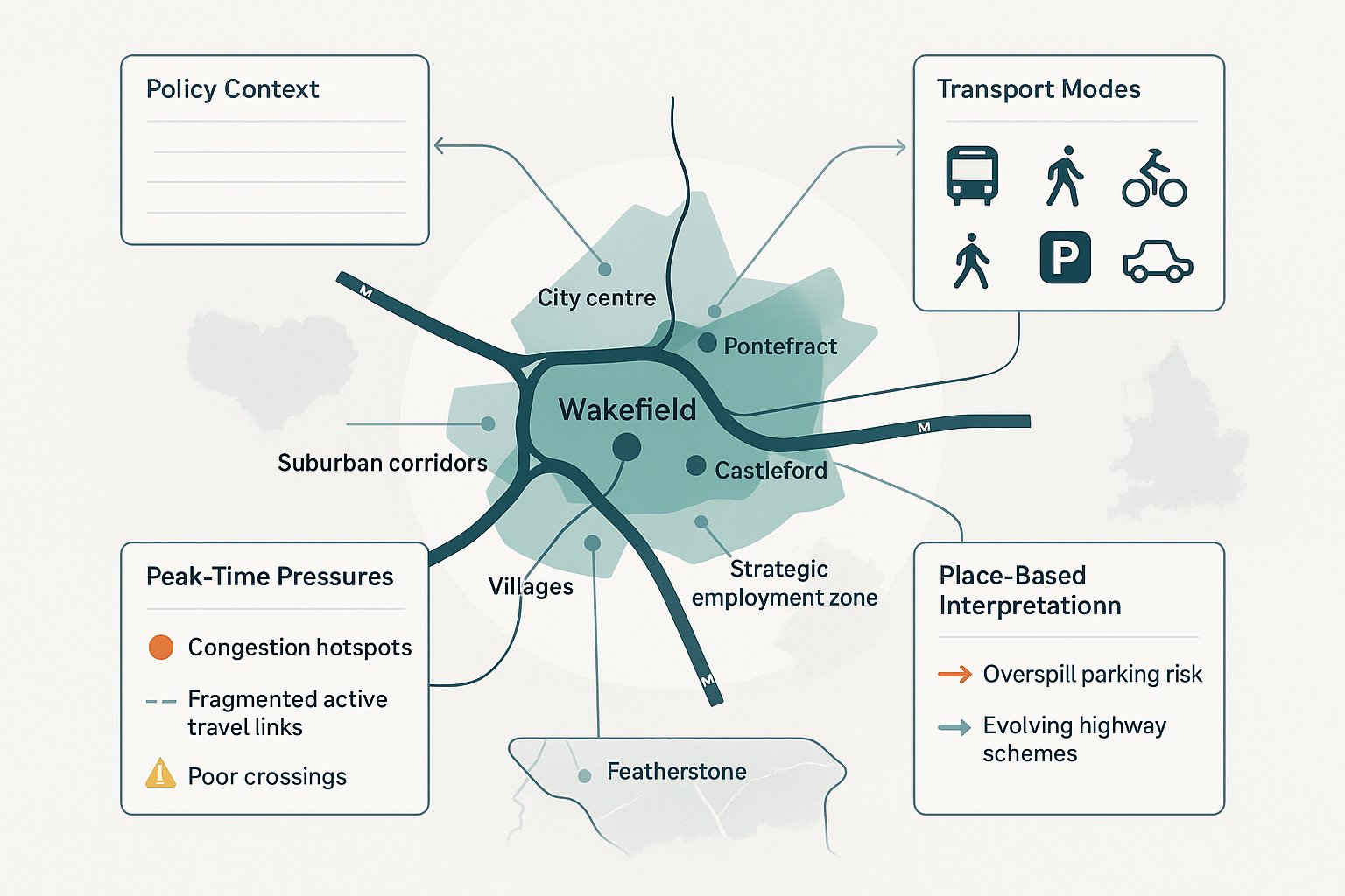
Any transport planning report for Wakefield should start with context, because local context drives scope. The district is shaped by a mix of urban centres, suburban corridors, villages, motorway influences and strategic employment locations. A site near Wakefield city centre raises different issues from one in Pontefract, Castleford, Featherstone or a more edge-of-settlement location.
At policy level, the main references usually include the National Planning Policy Framework, relevant planning practice guidance, the Wakefield Local Plan and the West Yorkshire Transport Strategy 2040. Depending on the proposal, we may also need to consider design guidance, parking standards, travel plan expectations and national highways or DMRB-based principles where the strategic road network is involved.
Several practical considerations come up again and again in Wakefield. Congestion on key corridors can be acute at school and commuter peaks. Bus accessibility varies significantly by location and time of day. Rail can be a strength for some sites, but irrelevant for others. Active travel routes may exist nearby yet be fragmented, indirect or uncomfortable to use. And proposed or emerging highway schemes can alter background traffic assumptions.
That is why local interpretation matters. A technically correct report can still feel weak if it does not reflect how people actually move around the area. We usually find that the strongest submissions combine policy compliance with a grounded reading of place: where congestion already bites, where crossing points are poor, where parking overspill is likely, and where sustainable mode opportunities are genuinely credible rather than just diagrammed onto a plan.
When A Development In Wakefield Needs Transport Evidence
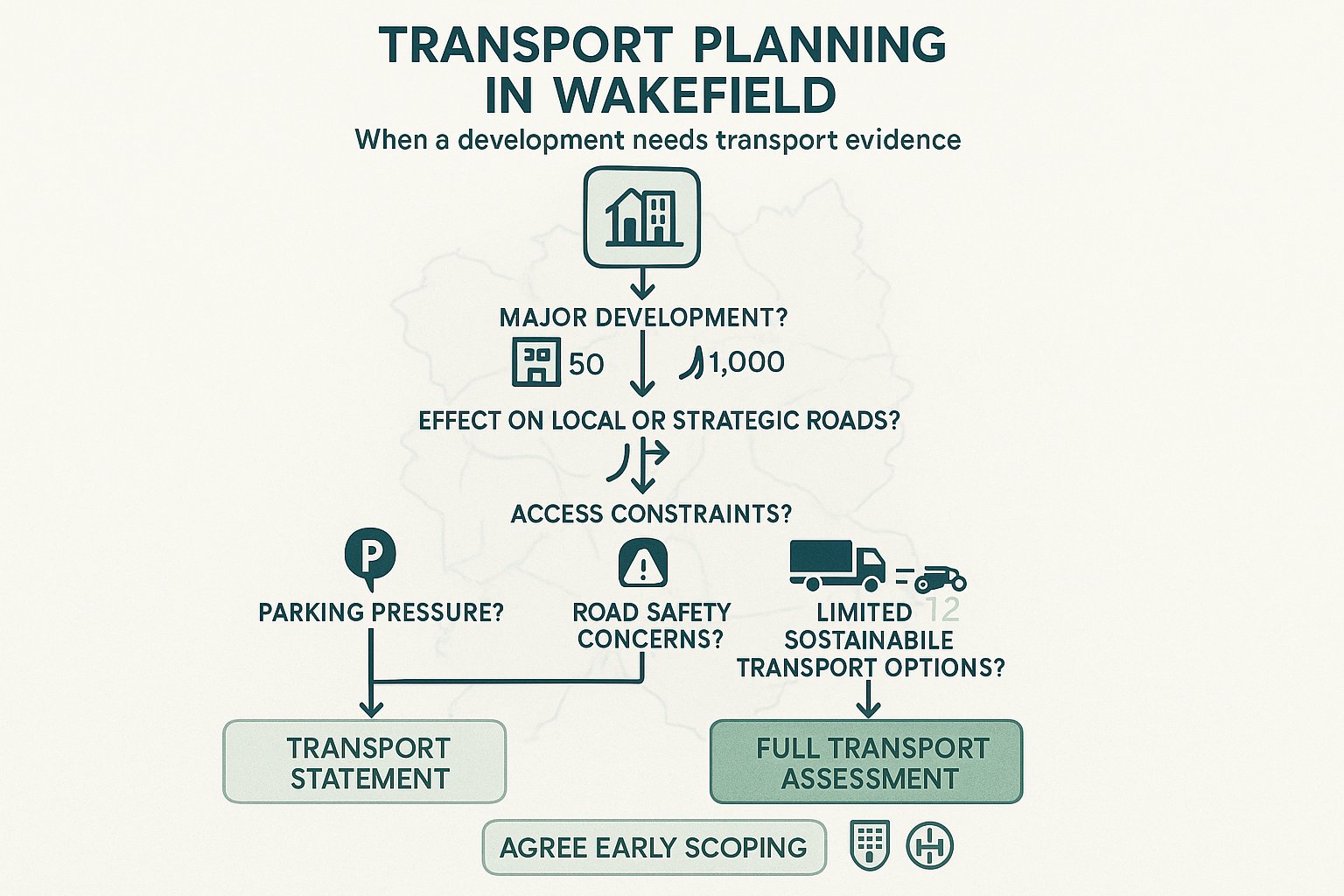
Not every planning application in Wakefield needs a lengthy transport document, but many more schemes need transport evidence than applicants assume. As a starting point, evidence is commonly required where a proposal amounts to major development, where it could materially affect the local or strategic highway network, or where there are specific concerns around access, parking, servicing or safety.
In broad terms, major development often means 10 or more dwellings, or non-residential floorspace of 1,000 square metres or more. But those are not magic numbers. A smaller scheme can still need a Transport Statement if it sits on a constrained frontage, near a sensitive junction, by a school, within an area of parking stress or in a location with limited sustainable transport options.
Likewise, some larger schemes may need a full Transport Assessment rather than a lighter statement because of their trip profile rather than just their size. A modest logistics use with concentrated HGV movements, for example, can create more technical concern than a larger but quieter office proposal.
The key point is that local validation requirements and pre-application feedback should guide the level of reporting. We generally advise clients not to guess. Early agreement with planning and highways officers on whether evidence is needed, and at what level, is usually far cheaper than submitting an application that later gets held up by an information request. In Wakefield, that early scoping step is often where the programme is won or lost.
Transport Assessment Vs Transport Statement: Choosing The Right Report
The difference between a Transport Assessment and a Transport Statement is less about branding and more about proportionality. In Wakefield planning applications, the right choice depends on likely transport effects, local sensitivity and what the council needs to determine the proposal with confidence.
A Transport Statement is usually appropriate for smaller or lower-impact schemes. It explains existing access conditions, estimates trip effects at a proportionate level, reviews parking and servicing, and addresses whether the development is likely to create material issues on the surrounding network. It should still be evidence-based, but the analysis is lighter and normally does not extend to detailed junction modelling unless there is a clear reason.
A Transport Assessment, by contrast, is the fuller option used for larger, more complex or potentially higher-impact developments. It typically includes a broader study area, more detailed baseline data, trip generation from TRICS or agreed local comparators, trip distribution and assignment, junction capacity assessments, sustainable travel analysis, and a more developed mitigation package. On some sites it will also feed into travel planning, road safety work and delivery planning.
The trap is choosing the lighter report simply to reduce upfront cost. If the site conditions or scale of impact point toward a TA, a thin TS rarely saves time. It tends to lead to challenge, rework and delay. Our usual approach is to agree the reporting level at pre-app stage, document the scope clearly, and make sure the submitted report answers the obvious questions before they are asked.
Typical Planning Thresholds And Triggers In Practice
In practice, Wakefield schemes often trigger transport evidence where they exceed major development thresholds, but that is only part of the picture. Schools, retail, roadside uses, employment sites and mixed-use proposals can all require detailed review even below headline thresholds if their traffic patterns are intense or awkwardly timed.
Typical triggers include:
- residential proposals above local major thresholds
- developments with notable peak-hour trip generation
- schemes with significant parking demand or likely overspill
- uses generating regular HGV or servicing activity
- proposals on constrained frontages or near sensitive junctions
- sites close to schools, town centres or established collision concerns
For example, a small foodstore may generate concentrated arrivals and servicing demand that justify more detailed assessment than a larger but lower-turnover use. A school expansion can also trigger strong scrutiny because pupil arrivals, parent parking and pedestrian safety often matter more than daily traffic totals.
So while thresholds are useful indicators, they are not a substitute for judgement. The practical test is whether the proposal raises transport questions that need structured evidence to answer.
What A Wakefield Transport Planning Report Should Cover
A good Wakefield transport planning report should read like a decision-making tool, not a box-ticking appendix. It needs to explain the proposal, the local network, likely effects and any mitigation in a way that planning officers, highways officers and third-party reviewers can follow without guesswork.
At minimum, we would expect the report to cover policy context, the site and surrounding highway network, local walking, cycling and public transport conditions, personal injury collision history where relevant, existing traffic conditions, the proposed site access arrangements, parking and servicing, and the expected trip impact of the development. The methodology should be transparent from the start: survey dates, agreed peak periods, traffic growth assumptions, committed development, assessment years and any software used.
In Wakefield, credibility often comes from proportionate local detail. A report should identify nearby bus stops and frequencies, but also whether those services are realistic for likely users. It should map pedestrian routes, but also mention if a crossing is inconvenient or a footway narrows to the point of discomfort. It should reference policy, but not hide behind policy language when a practical problem exists.
This is also where site design and transport evidence need to speak to each other. Access geometry, bin collection strategy, swept paths, cycle storage, EV charging, visibility splays and internal turning areas should align across all submitted drawings. Small inconsistencies are surprisingly common, and they undermine confidence quickly.
Trip Generation, Distribution And Junction Impact Assessment
Trip generation is often where technical scrutiny begins. For most Wakefield applications, that means using TRICS, agreed comparable sites or locally evidenced rates to estimate likely person and vehicle trips. The important word is likely. The exercise should reflect the actual development type, local context, day of operation and likely travel behaviour, not just whichever dataset produces the lowest numbers.
From there, trips need to be distributed and assigned through the network using a reasoned method. Census journey-to-work data, existing turning count patterns, local travel-to-school behaviour, committed developments and site-specific characteristics may all inform this stage. For mixed-use schemes, internal trip capture and linked trips may also need to be considered.
Junction impact assessment then tests whether key nodes can accommodate the additional demand. Depending on layout and control type, that may involve PICADY, ARCADY, LINSIG or another accepted modelling approach. The issue is not simply whether a ratio crosses a threshold: it is whether queues, delay, reserve capacity and network resilience remain acceptable in realistic scenarios.
Where impacts are material, mitigation should be specific. That could include access redesign, localised widening, signal optimisation, junction improvement, visibility enhancement, travel plan measures or, occasionally, a phased approach tied to occupation. Vague promises to “address matters later” rarely carry much weight.
Sustainable Travel, Accessibility And Active Travel Requirements
Wakefield policy expectations are no longer satisfied by adding a short paragraph on the nearest bus stop. Sustainable travel has become a central part of transport planning in Wakefield, particularly for residential, education, employment and mixed-use schemes.
A report should hence assess accessibility by walking, cycling and public transport in a realistic way. That includes route quality, directness, gradients where relevant, crossing opportunities, lighting context, cycle connections, bus stop infrastructure, service frequency and likely destination patterns. The question is not whether a footway exists on paper, but whether people would sensibly use it.
For larger schemes, a Framework or Full Travel Plan is often expected. Schools may need robust pupil and staff travel measures: workplaces may need incentives, monitoring and mode-share targets: residential schemes may need welcome packs, cycle provision, car club consideration or public transport support. The details vary, but the principle is consistent: sustainable access should be designed in from the start rather than offered as an afterthought.
This aligns with the wider West Yorkshire 2040 direction, which aims to make it easier to reach jobs, education and services by sustainable means. In planning terms, the strongest submissions are the ones that connect that strategic objective to the actual site experience, with deliverable measures rather than glossy aspiration.
Parking, Servicing And Highway Safety Considerations
Parking and servicing issues can derail an otherwise straightforward planning application, particularly in Wakefield locations where street capacity is already tight or where the development type has awkward peak demands. A transport report needs to do more than state a parking total: it should explain how the proposed provision relates to local standards, expected demand and site function.
That includes car parking, accessible spaces, cycle parking, motorcycle parking where relevant, EV charging and any operational overspill risks. If a scheme proposes below-standard parking, the justification must be more than “good sustainable location”. We need evidence on local accessibility, likely car ownership, permit controls if any, nearby on-street conditions and the nature of the intended occupiers or users.
Servicing deserves the same level of attention. Refuse vehicles, delivery vans, emergency access and, for commercial schemes, HGV routing all need to work safely and efficiently. Swept path analysis should match the actual vehicle types expected. If a delivery vehicle must reverse across a pedestrian route or wait on the highway, reviewers will notice.
Highway safety is the third pillar. Visibility splays, speed environment, crossing points, internal pedestrian priority and collision history all matter. On some schemes, a Road Safety Audit or independent review may be required. Even where not formally required, taking a safety-led approach usually strengthens the application. It shows that access has been designed for real users, including children, older people, disabled users and those arriving on foot or by cycle, not just for the turning radius of a car.
School, Residential, Commercial And Mixed-Use Schemes In Wakefield
Different land uses trigger different transport questions, and in Wakefield that distinction matters. A generic report written as if every site behaves the same is one of the easiest ways to lose credibility.
Schools usually attract the most sensitive review. The key issues are concentrated arrival and departure peaks, parent parking behaviour, school-street conditions, coach or minibus activity, staff parking and pupil walking routes. A good submission will look beyond gross traffic totals and deal with operational management, safeguarding and practical drop-off realities.
Residential schemes are often more straightforward, but not always. The council will usually want clear evidence on trip generation, access design, parking strategy and connections to local services, bus stops and, where relevant, rail stations. For larger residential sites, internal layout, pedestrian permeability and travel plan measures become more important.
Commercial and industrial developments tend to raise questions about servicing, HGV routing, staff travel, shift patterns and yard operation. Peak traffic may not align with commuter peaks, which can help, but heavy vehicles on unsuitable local roads can become a major concern. We usually find that routeing clarity and realistic servicing analysis make a big difference here.
Mixed-use schemes are the most nuanced. They require careful assessment of internal trip capture, shared parking, different peak profiles and cumulative effects on nearby junctions. Done well, mixed-use can reduce external travel demand. Done badly, it simply stacks multiple transport problems on one constrained site.
The lesson across all scheme types is the same: tailor the assessment to how the place will actually operate.
Common Reasons Transport Submissions Are Challenged Or Delayed
Most transport objections are not caused by one dramatic flaw. They usually build from smaller weaknesses that make the reviewing officer unsure whether the evidence can be trusted. And once that confidence slips, everything takes longer.
A common issue is poor scoping. The wrong assessment years, the wrong peak hours, too narrow a study area or failure to include a key junction can leave an otherwise competent report exposed. The same applies where baseline data is dated, collected in unusual conditions or not explained properly. If traffic counts were undertaken during abnormal operation, school holidays or network disruption, that needs to be addressed openly.
Another frequent problem is weak methodology. Trip rates may be selected without clear justification. Distribution assumptions can feel arbitrary. Sensitivity testing may be absent even where local conditions are volatile. Modelling outputs are sometimes appended without enough interpretation, as if pages of software printouts can speak for themselves. They can’t.
Sustainable travel is another pressure point. Reports are often challenged for giving too little attention to walking, cycling and public transport, or for making unsupported claims about likely mode share. In Wakefield, where policy is increasingly aligned with broader West Yorkshire objectives, that gap is more noticeable than it was a few years ago.
Then there is mitigation. If measures are vague, not costed, reliant on third-party land, or disconnected from the severity of impact, decision-makers may conclude the effects have not been properly resolved. A strong report does not avoid difficult issues: it names them early and shows how they can be dealt with.
How To Prepare A Strong Submission For Wakefield Planning Applications
The strongest Wakefield transport submissions are rarely the longest. They are the ones that are well scoped, technically sound and easy to interrogate. In practice, that starts before the application is submitted.
First, engage early with Wakefield Council planning and highways teams. Pre-application discussions can help confirm whether a Transport Statement or Transport Assessment is needed, what the study area should include, which junctions matter, whether committed developments need to be built in, and what level of travel planning or road safety work is likely to be expected. That early clarity is invaluable.
Second, align the report with the policy framework. National guidance matters, but local alignment matters just as much. The submission should show how the development responds to the Wakefield Local Plan, local transport policies and the West Yorkshire Transport Strategy 2040. A reviewer should be able to see that the methodology and conclusions fit the local decision-making context.
Third, make the evidence auditable. Use clear plans, consistent drawings, transparent assumptions and well-presented appendices. If we are relying on TRICS, census data, traffic surveys or modelling software, the logic chain from raw data to conclusion should be easy to follow. Ambiguity tends to invite challenge.
Fourth, set out realistic mitigation and implementation. That may include physical highway works, access amendments, parking controls, travel plan measures, delivery management or phased triggers tied to occupation. Timescales, responsibilities and deliverability should be clear.
This is where specialist support can genuinely save time. At ML Traffic, for example, the emphasis is on concise, accurate reporting tailored to local authority thresholds and planning contexts. That kind of focused approach tends to be far more useful than a generic national template dropped onto a Wakefield site.
Conclusion
Transport planning in Wakefield is, at heart, about showing that development can work in the real world. That means more than proving a junction still operates within modelled limits. It means understanding local growth patterns, policy expectations, travel behaviour, road safety, servicing realities and the increasing importance of sustainable access.
For applicants and their consultant teams, the practical route is clear: scope early, use evidence carefully, reflect Wakefield’s local context and be honest about impacts and mitigation. A well-prepared Transport Statement or Transport Assessment can do far more than satisfy validation requirements: it can improve site design, support negotiations and reduce planning risk.
And in 2026, that is exactly what good transport planning in Wakefield should achieve: development that aligns with the Local Plan and West Yorkshire’s wider transport vision while delivering safe, efficient and credible access for everyone who will use the site.
Frequently Asked Questions about Transport Planning in Wakefield
Why is transport planning important for development projects in Wakefield?
Transport planning in Wakefield is crucial because it manages local growth while addressing congestion, air quality and access to jobs and services. It supports sustainable, low-carbon travel aligned with the West Yorkshire Transport Strategy 2040, ensuring developments operate efficiently and safely for all users.
When does a development in Wakefield require transport evidence?
Transport evidence is typically required for major developments—such as schemes with 10 or more dwellings or non-residential floorspace over 1,000m²—or if a proposal materially affects the highway network, parking, servicing or raises safety/access concerns. Pre-application advice from Wakefield Council helps confirm requirements.
What is the difference between a Transport Assessment and a Transport Statement in Wakefield?
A Transport Statement is a lighter report for smaller, lower-impact schemes covering access and trip estimates, while a Transport Assessment involves detailed analysis, including junction modelling, for larger or high-impact developments. The choice is agreed with the council during pre-application discussions.
How does transport planning address sustainable travel and active travel modes in Wakefield?
Wakefield transport planning promotes sustainable travel by assessing realistic accessibility for walking, cycling and public transport. Larger schemes may require travel plans supporting mode shifts consistent with the West Yorkshire 2040 vision, ensuring developments are accessible and encourage low-carbon transport options.
What are common reasons for transport planning submissions being challenged or delayed in Wakefield?
Submissions often face delays due to poor scoping, omitting key junctions or peak periods, weak data or modelling quality, insufficient attention to sustainable travel modes, non-compliance with local policies, or vague, uncosted mitigation proposals lacking clear deliverability plans.
How can applicants prepare a strong transport planning submission for Wakefield planning applications?
Applicants should engage early with Wakefield Council to agree scope and methodology, align the report with local policy and the West Yorkshire Transport Strategy 2040, provide clear and auditable evidence and diagrams, and propose realistic mitigation and travel plan measures with defined responsibilities and timescales.