A college campus can create transport-planning questions before its first student arrives. A transport assessment for a new college campus in Harrow may be requested if the development is expected to generate additional travel demand or affect nearby roads, parking or public transport. Even a relatively modest proposal may need transport evidence when it is in a constrained area or near schools, town centres, or places with existing traffic and parking concerns.
It is understandable to focus on how many cars a campus might generate. Planning decisions also depend on how students, staff and visitors will travel to the site and how those journeys could affect the surrounding area. This article explains why Harrow Council may seek an assessment, what it examines and how public transport, walking and cycling fit into the picture. It also covers how traffic and parking impacts are assessed and how transport evidence can support a college planning application.
Key Takeaways
- Assess how students, staff and visitors can reach the campus by public transport, walking and cycling, not just by car.
- Use nearby bus routes and stops to understand the access options, while accounting for the campus’s location and site entrances.
- Identify how additional journeys could affect nearby junctions, parking demand and pedestrian access.
- Expect transport evidence to be relevant where a proposal could increase travel demand or affect roads, parking or public transport, including in constrained areas.
- Estimate college trips using the proposed campus activity and likely travel patterns, then present the assumptions clearly in the transport evidence.
Public transport, walking and cycling accessibility
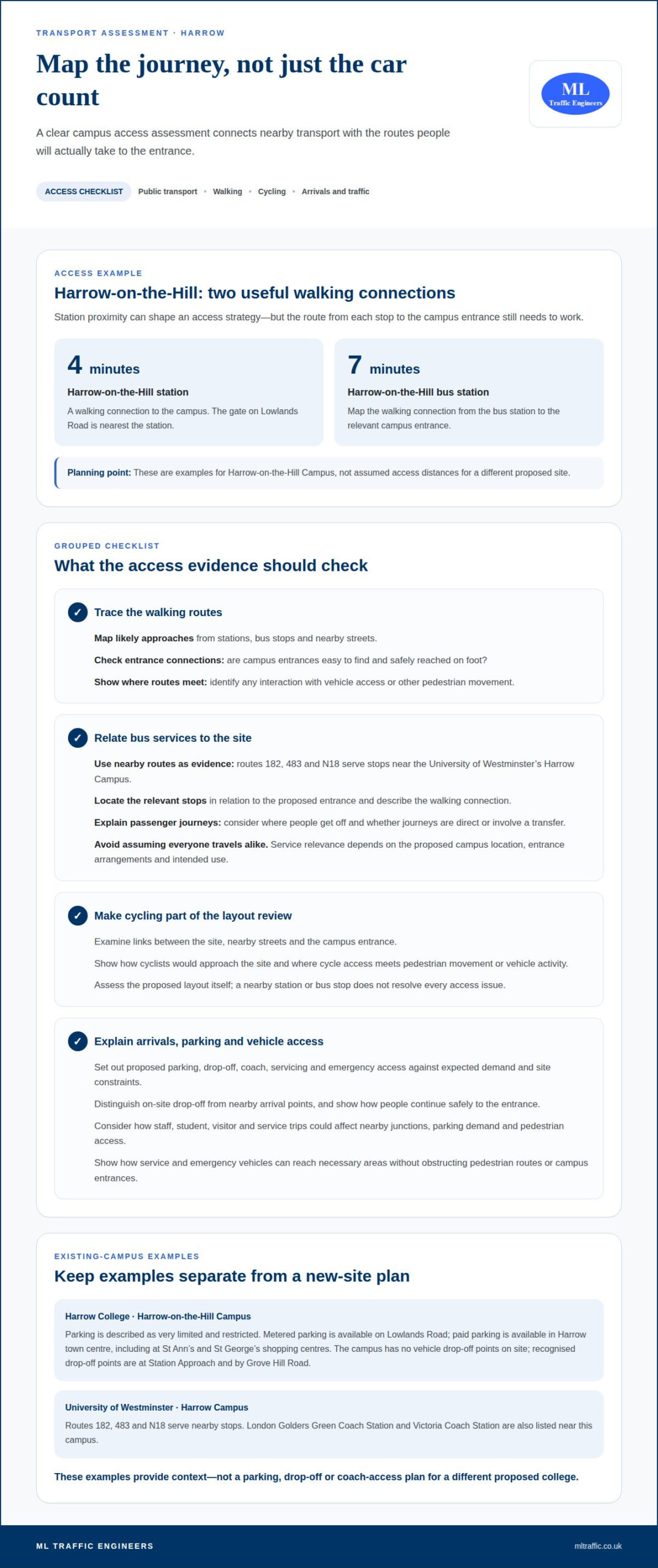
Harrow-on-the-Hill Campus shows how station proximity can shape a college access strategy. Harrow-on-the-Hill station is a 4-minute walk from the campus, while Harrow-on-the-Hill bus station is a 7-minute walk away. Pedestrians can use the gate on Lowlands Road nearest the station. These connections make the walking route between transport stops and the campus a practical part of access planning.
Distance alone does not show how accessible a campus will be. A transport assessment should map the routes students, staff and visitors are likely to use, including approaches from Harrow-on-the-Hill station and bus station. It should consider whether entrances are easy to find and can be reached safely on foot. The Lowlands Road gate illustrates how a campus entrance may connect with a nearby station.
Cycling should also be considered as a way to reach the campus. For a proposed Harrow campus, the assessment can examine links between the site, nearby streets and the entrance. It should identify how cyclists would approach the site and where cycle access meets pedestrian movement or vehicle activity. The analysis should reflect the proposed layout, rather than assume that a nearby station or bus stop resolves every access issue.
Existing campuses show why parking and arrival arrangements need careful attention. Harrow College advises visitors to use public transport because parking at its Harrow-on-the-Hill Campus is very limited and restricted. Metered parking is available on Lowlands Road, and paid parking is available in Harrow town centre, including at St Ann’s and St George’s shopping centres. These are examples, not a parking plan for a new campus.
For a new college in Harrow, the assessment should explain the proposed parking, drop-off, coach, servicing and emergency access in relation to expected demand and site constraints. The layout and provision depend on the development and its access arrangements, rather than on a figure that can be assumed for every campus.
Harrow College’s Harrow-on-the-Hill Campus has no vehicle drop-off points on campus. Its recognised vehicle drop-off points are at Station Approach and by Grove Hill Road. This example shows why a proposal should distinguish on-site drop-off from nearby arrival points and explain how people can continue safely to the entrance.
Coach access also depends on the particular campus. London Golders Green Coach Station and Victoria Coach Station are listed near the University of Westminster’s Harrow Campus. A transport assessment should explain the relevance of coach travel to the proposed site, alongside servicing and emergency vehicle access. For the latter, the site layout should show how vehicles can reach the necessary areas without obstructing pedestrian routes or campus entrances.
Bus stops and routes near Harrow Campus
Bus routes provide another part of the access picture around Harrow. Routes 182, 483 and N18 serve stops near the University of Westminster’s Harrow Campus. For a proposed college, route numbers alone don’t show whether bus travel will work well for students and staff. The assessment needs to relate nearby stops to the campus entrance, expected arrival patterns and the journeys people need to make. That distinction keeps the analysis focused on how the site functions, rather than simply listing services.
The location of bus stops matters as much as route coverage. An assessment should identify the stops closest to the proposed entrance and describe the walking connections between them. It should then consider whether people approaching from different directions can reach the site clearly. For example, a stop on one side of a road may serve one approach, while another may connect with a different entrance or campus destination. Mapping these relationships shows how bus access fits the site layout.
Route numbers 182, 483 and N18 offer concrete starting points for examining the University of Westminster’s Harrow Campus. For a new college, the transport professional considers which services are relevant to the proposed location and where passengers would get off. The analysis can also distinguish journeys made directly by bus from journeys involving a transfer. This gives the planning evidence a clearer account of how the campus relates to the surrounding public transport network.
Bus access should be considered alongside arrivals and pedestrian movement. The assessment can show where passengers would walk after leaving a stop and how those paths connect with campus entrances. It should consider whether the layout guides visitors to a clear entrance, rather than across vehicle access areas. These details show how bus travel connects with the campus, rather than treating a nearby stop as sufficient evidence on its own.
For planning, route and stop evidence can inform the wider account of expected travel choices. The proposed campus’s location, entrance arrangements and intended use all affect the relevance of nearby bus services. A transport professional can set out these factors and their implications without assuming that every student or staff member will use the same route. This gives the application a specific basis for explaining bus access.
Where routes, stops and campus access need to be considered together, the transport assessment planning guide explains how transport evidence supports a planning application.
Junction capacity and traffic impacts
A proposed college in Harrow can affect nearby junctions through staff, student, visitor and service trips. A transport assessment examines traffic generation and nearby junction performance, as well as parking demand and pedestrian access. Its purpose is to show how the development’s journeys relate to the existing highway network, rather than consider campus access in isolation.
The assessment begins by defining the roads and junctions relevant to the site. A junction belongs in the study area if campus traffic could use it on journeys to or from the college. For example, a road serving the main entrance may carry arriving cars, while another route may connect the site with nearby services. This focuses the analysis on connections associated with the proposal.
Traffic counts establish how people currently use the roads being assessed. The analysis then considers the additional vehicle trips associated with the college and how they could distribute across the network. For example, journeys entering from different directions may add pressure to separate approaches at the same junction. The assessment should explain the assumptions behind its trip estimates and route choices.
Junction capacity is not simply a matter of counting vehicles. The assessment considers how new traffic interacts with existing movements, including turning traffic and queues. A college entrance near a busy junction could affect how vehicles reach the site, while campus traffic joining an already constrained approach could influence wider movement. The report should link its findings to the specific junctions and routes examined.
Timing also shapes the analysis. Student arrivals and departures may coincide with staff journeys and the wider road network’s daily activity. If the campus timetable or travel patterns concentrate movements, the assessment should reflect that when examining traffic effects. It should not assume that every journey happens at the same time or follows the same route. The proposed operation and site access help determine the relevant scenarios.
Parking and pedestrian access form part of the same impact picture. If vehicles queue to enter the campus, they may interact with people walking near the entrance. If parking demand exceeds the proposed provision, additional vehicles may circulate nearby. Examining these connections shows how campus traffic, parking and access could affect neighbouring streets, rather than treating each issue separately.
For a new college in Harrow, the final account should identify the network studied, explain the traffic assumptions and present the junction findings. Where measured traffic data informs the analysis, its relationship to the assessment scenarios should be clear. This enables planning decision-makers to understand how the proposal could change local traffic conditions and which parts of the network need attention.
What transport assessment guidance and planning policies apply in Harrow and London?
For a college proposal in Harrow, transport evidence should address the development’s likely effects, rather than rely on its name or use alone. A Transport Assessment may be requested when additional travel demand could affect nearby roads, parking conditions or public transport infrastructure. The planning question is how the specific proposal relates to the surrounding transport network.
Scale is not the only consideration. Even a relatively modest development may need transport evidence if it is in a constrained area or near schools, town centres, or places with existing parking and traffic concerns. In Harrow, these circumstances can make the site’s context as important as the number of proposed buildings or campus users.
For a new college, planning evidence should connect the proposal with its access arrangements and expected journeys. The assessment can describe how students, staff and visitors may travel, then explain the implications for roads, parking and public transport. Its reasoning should reflect the proposed campus location and the network serving it, rather than offer a generic description of college travel.
Different planning documents can address different aspects of a development. Barnfield College commissioned a Transport Statement for its new college building and a Transport Assessment for the outline residential application on its Enterprise Way campus. Its Travel Plan was approved to discharge the relevant planning condition for the first phase of redevelopment. This example shows that the evidence submitted can vary with the application and its planning requirements.
A Travel Plan has a distinct purpose: it is a long-term plan to reduce car journeys and support walking, cycling and public transport, using targets and monitoring. For a Harrow college, it can complement transport evidence by setting out how sustainable travel will be encouraged after occupation. It does not replace analysis of the proposed development’s transport effects.
A clear planning submission should make the links between the proposal, evidence and identified effects easy to follow. For example, if a Harrow site is near a school or town centre, the assessment should explain why that context matters to travel demand or local conditions. If parking or public transport could be affected, the relevant analysis should address the issue directly. This distinguishes project-specific reasoning from broad claims about education developments.
The appropriate evidence depends on the application and its location in Harrow. A transport professional can align the assessment’s scope with the campus proposal, explain the assumptions and present findings to support planning consideration. This keeps the planning case focused on the development’s actual travel demand and potential effects.
How does a transport professional estimate student and staff trip generation for a college?
A transport professional starts with the proposed college’s operating profile. Student and staff numbers, course patterns and campus activities shape expected travel demand. The assessment uses these details to distinguish user groups and their likely arrival and departure patterns. A campus with varied teaching times may generate movements differently from one with concentrated class starts. Estimates should reflect the proposal, not a generic assumption about every college.
Next, the professional considers how often students and staff attend in person. Course timetables, attendance patterns and staff working arrangements help describe who travels and when. The assessment can distinguish journeys associated with teaching periods from other campus activity. For example, a changeover between classes may influence when people arrive or leave. Clear assumptions show how the college’s daily operation informs predicted travel demand.
Mode choice is another part of the calculation. The professional considers how students and staff may travel by car, bus, rail, cycling or walking, using the campus location and available access options. Harrow-on-the-Hill station and routes 182, 483 and N18 provide local examples of public transport connections already discussed. The analysis should explain how those connections relate to the proposed site, rather than assume every user chooses the same mode.
Trip generation distinguishes people from vehicle movements. Several students travelling together may generate fewer car movements than separate solo journeys, while a staff member driving alone makes a vehicle trip. The professional assesses likely travel modes and vehicle occupancy assumptions, then estimates vehicle movements separately from total person journeys. This distinction matters when considering effects on roads and junctions around a Harrow campus.
After estimating trips, the professional considers where journeys begin and end. The campus location, nearby connections and likely destinations inform how traffic may distribute across local roads. For example, vehicle movements approaching from different directions may affect different junctions. The assessment should link trip-generation assumptions to the routes examined, so predicted movements can be understood in the context of local network conditions.
Finally, the report records its inputs, assumptions and resulting estimates. If the proposed enrolment, timetable or access arrangements change, travel demand may change too. A transparent explanation lets planning decision-makers see how the estimate relates to the development submitted. For a college application in Harrow, this provides a project-specific basis for assessing student and staff journeys, rather than relying on an unsupported headline figure.
For a project-specific assessment of college travel demand, discuss transport assessment support.
ML Traffic Engineers UK: Transport Assessments
ML Traffic Engineers UK prepares Transport Assessments for college proposals that need evidence on travel demand, access and local traffic effects. For a smaller proposal, a Transport Statement may provide the relevant planning evidence. Parking Surveys can inform the analysis of campus parking demand, while Swept Path Analysis can assess how vehicles manoeuvre within the proposed layout.
Turn to ML Traffic Engineers UK when a Harrow campus proposal needs transport evidence tailored to its site, users and access arrangements. The assessment can connect trip estimates with parking analysis and nearby transport effects, helping present a project-specific case for planning consideration.
Contact ML Traffic Engineers UK to discuss transport evidence for your college proposal.
Move your college proposal towards its next stage
A well-scoped transport assessment for a new college campus in Harrow gives decision-makers a clear account of the proposal’s transport implications. The next step is to align the evidence with the site, planned campus activity and the questions raised by the planning application. This keeps the assessment focused on the development instead of broad assumptions.
ML Traffic Engineers UK supports this work through Transport Assessments and Transport Statements. Parking Surveys can inform the parking evidence, while Swept Path Analysis can assess vehicle movements within the proposed layout. The appropriate combination depends on the evidence needed for the proposal.
Bringing transport planning into the project at the right stage can help clarify what evidence the application needs and how its assumptions should be presented. Contact ML Traffic Engineers UK to discuss transport planning for your college proposal. With a clear scope and project-specific evidence, you can move forward with greater confidence.
Frequently Asked Questions
Why might Harrow Council request a Transport Assessment?
Harrow Council may request an assessment when a proposal could increase travel demand or affect nearby roads, parking or public transport. A college can generate journeys by students, staff, visitors and service vehicles, so the planning authority needs evidence about the proposal’s effects. A constrained location or a site near a school or town centre can also make transport considerations relevant, even for a modest development.
What is a transport assessment for a new college campus in England?
A transport assessment for a new college campus in Harrow is a planning document examining how the proposed development may affect travel and the surrounding transport network. It relates the campus’s expected journeys to access arrangements, nearby roads, parking and public transport. Its findings explain the transport implications of the application. The assessment is tailored to the proposal, rather than based on a universal template for every college.
When is a transport assessment or transport statement required for a college development in Harrow?
Whether a proposal needs a Transport Assessment or Transport Statement depends on its likely travel demand and effects. Harrow developments may need transport evidence where roads, parking or public transport could be affected. A constrained location or proximity to a school or town centre can also matter. The application’s scale alone does not determine the evidence needed; the development’s location, access and expected travel patterns inform its scope.
What are the traffic and highway conditions near the proposed campus site in Harrow?
Conditions vary between Harrow sites, so assess the proposed location in relation to its surrounding roads and junctions. Evidence can examine existing traffic movements, parking activity and pedestrian access, then relate those conditions to the college proposal. A site near a town centre may have different access considerations from one on a quieter road. Traffic Surveys can provide data to understand local movement patterns.
What public transport services and capacity are available near the Harrow campus site?
Public transport provision is site-specific. Routes 182, 483 and N18 serve stops near the University of Westminster’s Harrow Campus, while the services relevant to a new college depend on its location. A transport assessment can distinguish nearby route availability from the capacity to accommodate additional campus users. That requires considering the site’s connections and expected travel demand, rather than assuming proximity alone demonstrates sufficient service capacity.
What walking and cycling routes, facilities, and accessibility issues are near the site?
Consider walking and cycling access along the routes people are likely to use to reach the proposed campus entrance. For example, an assessment can examine whether approaches from nearby streets connect clearly with site access and where walking and cycling movements meet vehicle routes. Relevant facilities and accessibility considerations depend on the site layout and surroundings. This helps identify access issues specific to the proposal.
What traffic modelling, junction surveys, and assessment methods are required for a college transport assessment?
Choose methods to match the proposed development and the transport effects being examined. Traffic Surveys can collect evidence about existing movements, while junction analysis can assess how campus trips interact with nearby traffic. The assessment should explain its assumptions, including how trips are estimated and distributed across routes. The need for modelling or further survey work depends on the site, access arrangements and potential effects identified for Harrow.
What are the likely transport impacts, safety risks, and mitigation options for the campus?
Potential impacts include additional traffic, pressure on parking, changes to junction performance and conflicts between vehicles and people walking or cycling. The assessment should link each concern to the proposed campus layout and expected journeys. Mitigation can then address identified effects, such as encouraging travel choices through a Travel Plan or reviewing vehicle movement within the site through Swept Path Analysis. Measures should respond directly to the evidence.

Disclaimer
The content on mltraffic.co.uk, including all technical articles, guides, and resources, is provided for general informational and educational purposes only. It is not intended to constitute professional advice in traffic engineering, transportation planning, development approvals, or any other technical or legal field.
While ML Traffic Engineers makes every reasonable effort to ensure the accuracy, completeness, and timeliness of the information published, we do not provide any warranties or representations (express or implied) regarding its reliability, suitability, or availability for any particular purpose. Any reliance you place on the content is strictly at your own risk.
In no event shall ML Traffic Engineers, its directors, employees, authors, or affiliates be liable for any direct, indirect, incidental, special, consequential, or punitive damages (including, without limitation, loss of profits, data, or business opportunities) arising out of or in connection with the use of, or inability to use, any information provided on this website.
The articles and guides on this site are not a substitute for engaging a qualified, professional traffic engineer to assess your specific project requirements. For tailored advice, compliance assessments, or traffic engineering services, please contact a competent professional.
This disclaimer may be updated from time to time without notice. By accessing or using this website, you agree to be bound by the most current version of this disclaimer.