If a layout looks fine on paper but a refuse lorry can’t turn, the planning risk shows up fast. That’s why swept path and vehicle tracking sit at the centre of so many UK planning applications, transport statements and highway negotiations. They answer a very practical question: can the vehicles that need to use a site actually get in, manoeuvre safely, and leave without conflict?
For architects, planners, developers and local authorities, this isn’t a box-ticking exercise. A junction may appear generous, a service yard may seem workable, and a turning head may satisfy a rough rule of thumb. But until we test the movement of real vehicles against the proposed geometry, there’s no reliable evidence that the design works in day-to-day operation.
In practice, swept path analysis uses specialist software such as Autodesk Vehicle Tracking or AutoTURN on CAD-based site layouts to simulate wheel paths, body overhang, tail swing and overall clearance. The result is a set of drawings that can support planning submissions, respond to highway comments, and often prevent expensive redesign later.
In this guide, we’ll explain what swept path and vehicle tracking mean in practice, which vehicles usually need testing, the site design issues that most often affect the results, and what UK local authorities typically expect to see in 2026. We’ll keep it practical, planning-focused, and aligned with how these assessments are actually used on live development projects.
What Swept Path And Vehicle Tracking Mean In Practice
Swept path analysis and vehicle tracking are methods used to predict the physical space a vehicle occupies while turning or manoeuvring. That includes not only the line of the wheels, but also the wider area taken up by the body of the vehicle as it swings through a movement. In other words, we’re checking the true envelope of motion, not just whether a route looks wide enough by eye.
On live projects, this is usually carried out using specialist software linked to a CAD site layout. We input the relevant vehicle type, define the route or manoeuvre, and simulate how it moves through the proposed access, internal road, turning head, car park or service yard. The software then plots the inner wheel track, outer body sweep and key overhang points, which can be overlaid directly on the drawing.
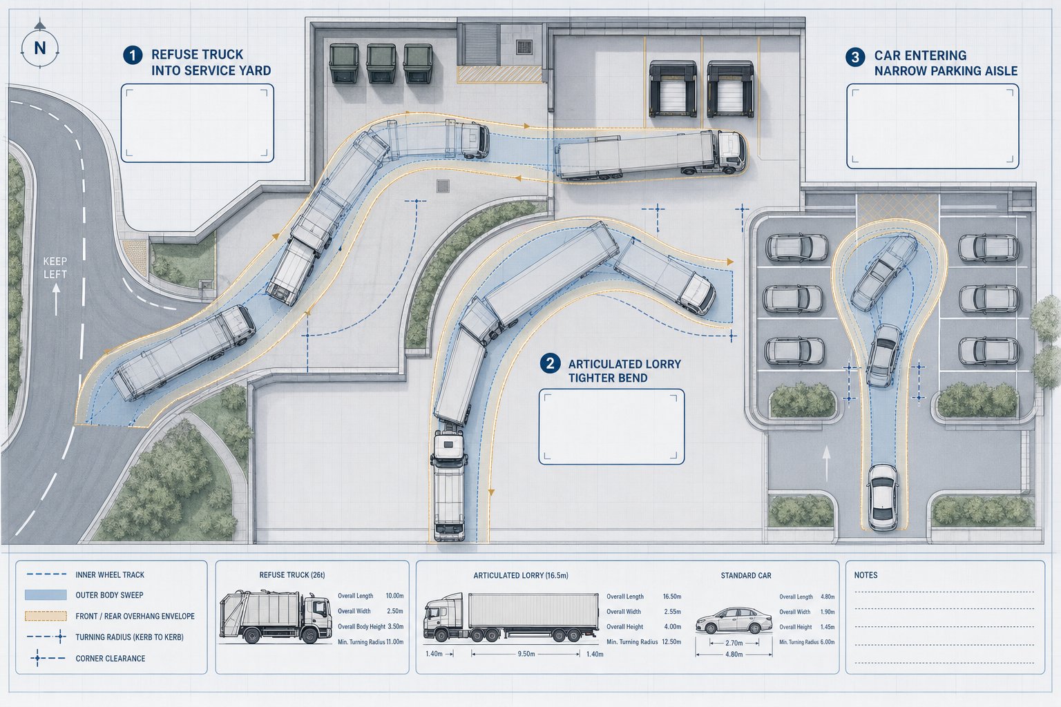
That matters because different vehicles behave very differently. A large rigid refuse vehicle cuts in sharply on turns. An articulated lorry creates a different tracking pattern again. Even a standard car entering a tight parking aisle can need more clearance than a simple dimension check suggests.
In practice, good swept path work is part engineering, part judgment. We need the right design vehicle, realistic assumptions, and a layout that is developed enough to test properly. Done well, it gives everyone involved a clearer answer to a deceptively simple question: will the site work once it’s built?
Why They Matter For Planning Applications And Highway Approval
Planning officers and highway authorities want evidence, not optimism. That’s the core reason swept path and vehicle tracking matter. Where a development depends on refuse collection, emergency access, deliveries, parking circulation or turning space, drawings need to show that those movements can happen safely and without unacceptable conflict.
For many UK schemes, that evidence is expected as part of a transport statement, transport assessment, servicing note or general planning pack. Residential developments often need to demonstrate that refuse vehicles can approach and turn. Commercial and mixed-use sites may need delivery and service vehicle tracking. And almost every scheme with internal access roads or constrained geometry raises the question of emergency vehicle access.
These drawings also help resolve the most common planning concerns. Will a lorry overrun the footway at the site entrance? Does a fire appliance need to reverse too far? Can a vehicle exit in forward gear? Will turning movements depend on using the opposing lane or clipping parked cars? Those are exactly the issues that can generate objections, conditions, or redesign requests.
From our perspective, early tracking work almost always saves time. It is far easier to adjust a kerb line, move a bay, or widen a service area before a submission goes in than after comments come back from the local highway authority. And when the layout is unusual or constrained, properly prepared tracking can justify a design decision that might otherwise be challenged.
How Vehicle Tracking Shows Real Vehicle Movement On A Site
Vehicle tracking turns a static site plan into something closer to real operation. Instead of looking at a junction, aisle or service yard as a set of dimensions, we test how a specific vehicle actually moves through it. The software models the geometry of the chosen vehicle and calculates the paths of the wheels, the outer swept envelope of the body, and the areas affected by overhang or tail swing.
That output is then placed over the proposed layout. We can see where a front corner swings towards a wall, where rear wheels cut across a kerb radius, or whether a long vehicle needs to take too much of the carriageway to complete the manoeuvre. Clearances to bollards, parking bays, gates, bin stores, boundary walls and other fixed features become visible very quickly.
It’s especially useful because site design rarely fails in one obvious place. A route may be acceptable at the entrance but break down at an internal bend. A delivery vehicle may be able to enter a yard but not leave it neatly. A refuse lorry may technically reach the collection point, yet only by sweeping across bays that are meant to remain parked. Tracking helps us see these pinch points before they become planning issues or operational problems.
The result is a drawing set that is visual, measurable and difficult to argue with when prepared properly.
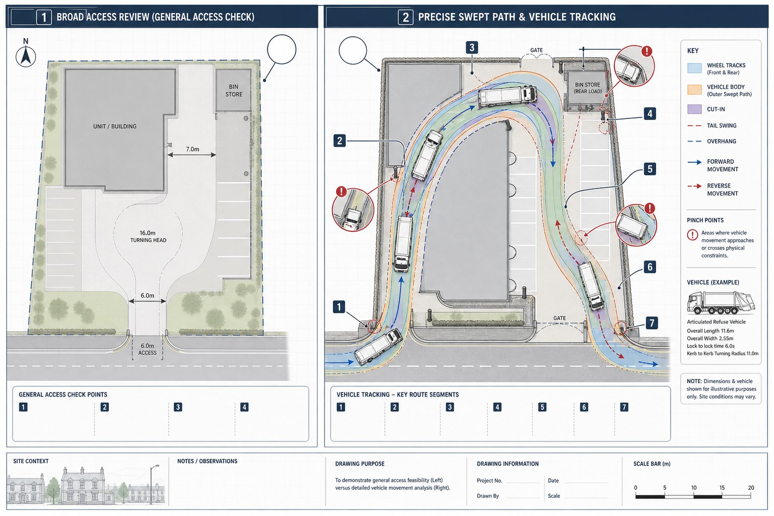
The Difference Between Swept Path Analysis And General Access Checks
A general access check asks broad questions: is there an access point, is the turning head present, does the road look wide enough? That level of review has its place early on, especially in concept design. But it is not evidence that a particular vehicle can complete a movement safely.
Swept path analysis is more precise. It tests a defined vehicle on a defined route and measures what happens as it turns, reverses, swings out and cuts in. It captures wheel tracking, body overhang, articulation where relevant, and the clearances left to surrounding features.
That distinction matters in planning. A scheme can pass a casual sense-check and still fail once a realistic refuse vehicle or fire appliance is tracked. We’ve seen layouts where the access looked generous until the tail swing clipped a boundary wall, and others where a turning area seemed adequate until the rear axle path showed repeated overrun of a footway.
So while general access checks are useful at feasibility stage, they should not be confused with swept path analysis. If the planning outcome depends on proving that vehicles can use the site, the quantitative test is the one that carries weight.
Which Vehicles Should Be Tested For A Development
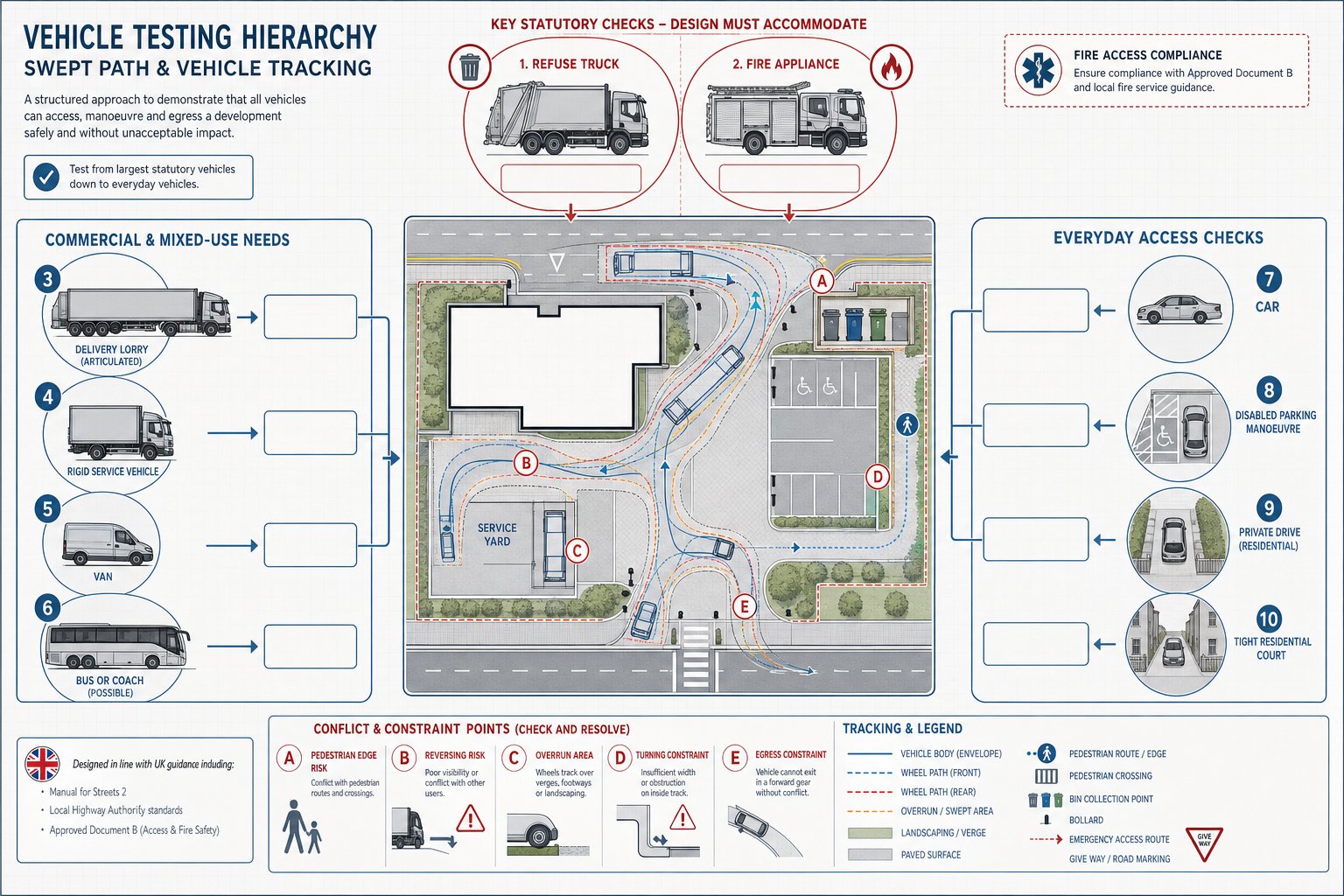
The right vehicle list depends on the use, scale and operational pattern of the development. But in UK planning practice, there are some recurring expectations. We need to test the vehicles that will realistically and routinely use the site, plus any emergency or statutory access vehicles that local guidance requires.
For residential schemes, that usually means at least a refuse vehicle and a fire appliance, alongside cars using access roads, parking courts and turning areas. For employment, retail, logistics or mixed-use projects, the list often expands to include delivery lorries, service vehicles, maintenance vans and sometimes articulated HGVs. Where public transport infrastructure is involved, buses or coaches may also need to be checked.
A common mistake is choosing a vehicle that is convenient rather than realistic. If the local authority or waste contractor uses a particular refuse vehicle type, that should usually be the starting point. Likewise, where servicing is central to the use of the site, a generic van model may not tell us much if the occupier will in reality rely on larger rigid lorries.
The aim is not to create the longest possible test list. It is to create the right one. Over-testing can muddy the picture, but under-testing creates planning risk and often leads to requests for further work.
Refuse Vehicles, Fire Appliances, Delivery Lorries, And Service Vehicles
These are the vehicles most likely to drive technical comments from highway officers. Refuse vehicles are critical on residential developments because collection arrangements need to be practical, not theoretical. Many authorities expect a standard vehicle around the 11.2 m class, though local fleet details can vary and should always be checked.
Fire appliance tracking is also commonly expected. Even where the highways role overlaps with building regulations or fire access considerations, planning teams often want confidence that emergency vehicles can approach appropriately and, where relevant, turn or leave without unsafe manoeuvres.
Delivery and service vehicles become especially important on commercial sites, care facilities, schools, retail units and mixed-use schemes. Here the question is not just whether a lorry can enter, but whether it can load, turn, and exit without blocking circulation or overrunning pedestrian areas. If servicing strategy depends on a specific vehicle type, the drawings should reflect that.
And this is where realistic operational assumptions matter. A service yard that only works if every driver steers perfectly at a crawl and no other vehicle is present may not satisfy an authority reviewing the scheme in practical terms.
Cars, Vans, Disabled Bays, And Residential Access Requirements
Smaller vehicles matter too, particularly where the design includes tight parking layouts, private drives, basement ramps, mews courts or constrained residential access roads. A site can accommodate a refuse vehicle at the entrance and still fail on ordinary day-to-day usability for residents.
Car tracking is often needed to show that vehicles can enter and leave spaces cleanly, manoeuvre within aisles, and exit in forward gear where required. Vans may also be relevant where trades, maintenance or light commercial activity form part of normal site use. This is particularly common on mixed-use and urban infill sites where circulation space is limited.
Disabled parking needs careful review. It’s not just a question of fitting a bay dimension onto the plan. We should consider approach angles, door opening space, nearby obstructions, and whether a vehicle can actually align and park without awkward multi-point movements.
For residential access, local authorities frequently focus on whether cars can turn within the site rather than reverse out onto the public highway. That issue comes up repeatedly on small developments. A simple turning diagram can be the difference between a smooth planning decision and a prolonged request for revisions.
Key Site Design Issues That Affect Tracking Results
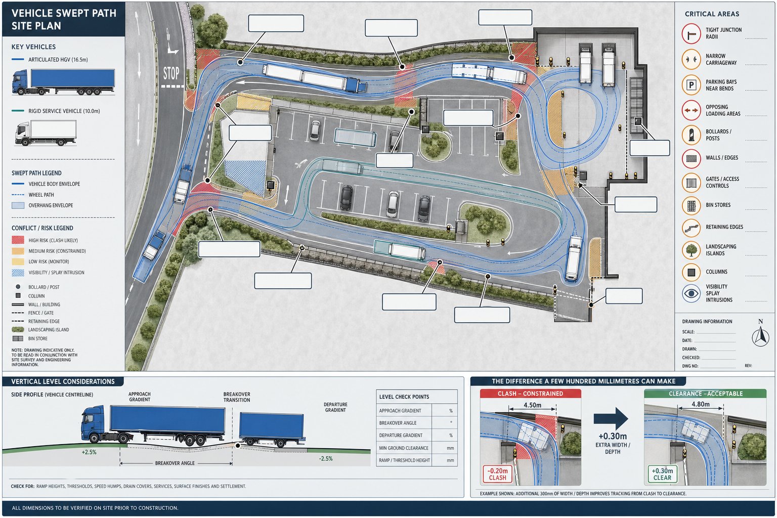
A vehicle tracking exercise is only as good as the layout it tests. Small geometric choices can produce major differences in the result, especially on constrained sites. The obvious factors are junction radii and carriageway width, but they’re only part of the picture.
Parking and loading layouts regularly influence tracking more than teams expect. A bay positioned close to a bend, a loading area placed opposite a turning movement, or an aisle narrowed by columns or landscaping can turn a workable route into a conflict point. The same goes for walls, gates, bollards, retaining structures, bin stores and visibility splays that reduce usable width even where the drawing seems generous overall.
Turning heads and service yards deserve particular care. Some look compliant in shape yet fail because a long vehicle needs more depth to straighten, or because the assumed route relies on sweeping across areas that will be occupied in normal use. Internal junction spacing is another common issue: when bends or access points are too close together, one manoeuvre can compromise the next.
Levels matter as well. Long wheelbase vehicles on steep gradients or at sharp vertical transitions can experience practical problems beyond a simple horizontal tracking diagram. That’s why near-final CAD information, including levels where relevant, gives much more reliable output than an early sketch.
In short, tracking results are shaped by details. A few hundred millimetres in the right place can resolve a planning comment: in the wrong place, it can create one.
Common Problems Found In Vehicle Tracking Assessments
The same issues appear again and again in swept path reviews. One of the most common is a manoeuvre that only works by taking the full width of the carriageway, including the opposing lane. In a quiet private yard that may be manageable. At a site access or shared internal road, it can create obvious conflict and attract highway concern.
Another regular problem is overrun. We see vehicles clipping kerbs, mounting footways, encroaching into verges, crossing into parking bays, or sweeping through pedestrian space that was never intended to be shared with large vehicles. Sometimes the conflict is small on paper but significant in practice, especially where formal footways or boundary features are involved.
Reversing is a further trigger point. Long reverse distances within a site are often discouraged, and reversing onto or from the public highway is rarely acceptable for larger vehicles. A layout that depends on extensive reversing by refuse or service vehicles usually needs redesign unless there is a very clear operational justification.
Then there’s the issue of realism. Some layouts can be made to work in software only by using idealised steering inputs, low-speed assumptions, or a route that ignores likely parked vehicles. Authorities are increasingly alert to that. A credible assessment should reflect how the site will actually operate, not just how it behaves in a best-case simulation.
The value of the assessment lies in exposing these weak points early enough to fix them.
How Swept Path Drawings Support Transport Statements And Planning Packs
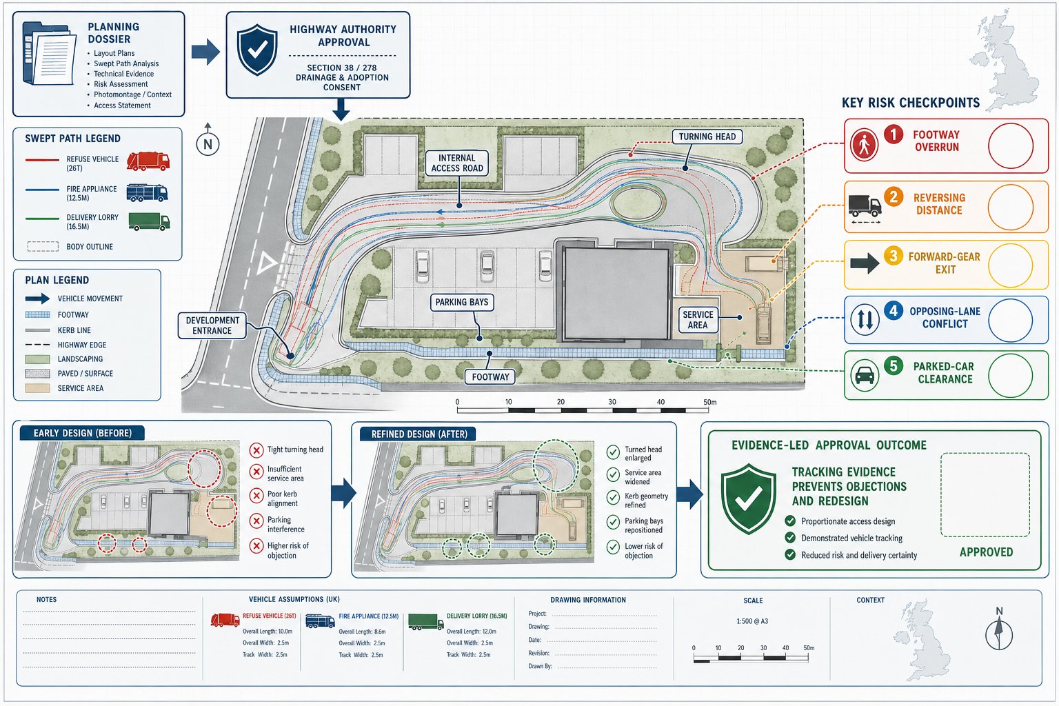
Swept path drawings are often one of the most useful pieces of technical evidence in a planning pack because they convert a design claim into something visible. Rather than stating that vehicles can access, turn and leave safely, we can show it. That has real value in transport statements, transport assessments, delivery and servicing notes, and planning responses.
For straightforward schemes, the drawings may simply confirm that standard vehicles can use the access and internal layout as proposed. For more constrained developments, they help explain why a design still functions even though tight geometry, unusual boundaries or departures from standard dimensions. In both cases, they support the narrative of the wider report.
They’re also practical when comments come back from the local authority. If an officer queries refuse access, emergency vehicle turning or servicing arrangements, a well-prepared tracking drawing lets us answer precisely rather than generically. It can show the tested route, the design vehicle used, and whether any accommodation measures are built into the proposal.
From our side at ML Traffic, this is where concise, authority-aware reporting matters. The best planning material doesn’t overwhelm readers with unnecessary graphics: it gives them the evidence they need to make a decision. Clear tracking plans, tied to the written assessment, often do that better than pages of loose commentary.
What Local Authorities Typically Expect To See
Although requirements vary between councils, the broad UK expectation is fairly consistent. Authorities want to see the right vehicle types, realistic manoeuvres, and clear drawings that identify whether conflicts occur at the key points of access and circulation.
That usually means plans covering the site entrance, internal junctions, turning heads, service yards, loading areas, emergency routes and any constrained parking movements. The drawings should show tracked wheel paths and the wider swept envelope of the vehicle body. If there are overruns or dependencies on non-standard operation, those should be obvious and explained rather than hidden.
Vehicle choice matters. Many councils expect the analysis to reflect local vehicle types, particularly refuse fleets. If a specific authority standard or vehicle library applies, we should use it. Speeds and assumptions should also be credible. Some authorities publish modelling parameters, such as low forward manoeuvring speeds and very low reverse speeds, and it makes sense to align with those where relevant.
Increasingly, reviewers also look beyond an empty-site scenario. If on-street parking, loading activity or likely parking behaviour will affect the manoeuvre, they may expect that to be acknowledged. A drawing that works only when every bay is empty can be less persuasive than one that reflects normal occupation.
Good submissions make the authority’s review easier. That usually improves the outcome.
How To Prepare Good Information Before Commissioning An Assessment
The quality of a tracking assessment depends heavily on the information provided at the outset. If the layout is too early, the levels are missing, or the vehicle assumptions are unclear, the output may be provisional at best. That can still be useful at feasibility stage, but it won’t always stand up well in a planning submission.
The ideal starting point is a final or near-final CAD layout showing kerbs, carriageways, parking, boundaries, buildings, gates, walls, landscaping features and any fixed obstructions. If gradients or vertical geometry may affect larger vehicles, levels should be included as well. Without that, horizontal tracking can give a false sense of confidence.
We also need an agreed vehicle list. That should cover refuse, fire, delivery, service, bus or car movements as relevant to the scheme. Where local highway authority standards or known refuse fleet details exist, those should be passed through before modelling begins. It saves revisions later.
Operational assumptions are just as important. Will servicing occur from a bay or on-street? Are parking spaces assumed occupied during the manoeuvre? Must vehicles exit in forward gear? Where are refuse collection points located? Those practical details shape the test.
In our experience, the fastest and cleanest assessments happen when the project team provides coordinated drawings, realistic vehicle requirements and any authority-specific guidance from day one. It sounds basic, but it makes an enormous difference.
Conclusion
For UK development projects, swept path and vehicle tracking are not decorative add-ons. They are one of the clearest ways to prove that a site will function safely and practically once built. When prepared properly, they show whether refuse vehicles, fire appliances, delivery lorries, cars and service vehicles can move through a layout without avoidable conflict.
That matters to architects, planners, developers, legal teams and councils alike because access problems have a habit of surfacing late and costing more than expected. Early, realistic analysis helps us catch design issues while they are still easy to solve, supports transport statements with hard evidence, and gives highway officers what they typically need to assess a proposal.
In 2026, the standard is simple: use the right vehicles, test the real movements, and present the results clearly. If we do that, planning applications are stronger, reviews are smoother, and the finished development is much more likely to work as intended in everyday use.
Frequently Asked Questions about Swept Path and Vehicle Tracking
What is swept path analysis and why is it important in UK planning applications?
Swept path analysis uses specialist software to simulate a vehicle’s wheel paths and body movement on a site layout. It provides evidence that vehicles like refuse lorries and fire appliances can manoeuvre safely, helping secure planning and highway approvals by showing practical, not just theoretical, access.
Which types of vehicles typically need to be tested in vehicle tracking assessments for developments?
Common vehicles include refuse vehicles (around 11.2 m), fire appliances, delivery lorries, service vehicles, buses or coaches where applicable, cars and vans, and disabled parking vehicles. Testing assures realistic, routine access for all relevant users as expected by UK local authorities.
How does vehicle tracking differ from general access checks in site design?
General access checks are broad reviews asking if access points or turning heads exist. Swept path analysis quantitatively simulates a specific vehicle’s movement, including wheel tracks and body overhang, providing precise proof that the vehicle can safely complete manoeuvres on the site.
What common site design issues can affect the results of swept path and vehicle tracking?
Key factors include junction radii, carriageway widths, positioning of parking and loading bays, geometry of turning heads, obstacles like walls or bollards, and gradients. Even small geometric details can cause conflicts or prevent safe manoeuvres if not carefully considered.
Can swept path drawings help address highway authority concerns during planning reviews?
Yes, swept path drawings visually and measurably demonstrate vehicle movements, highlight conflicts, and justify design decisions. They support transport assessments and servicing plans by providing clear evidence that vehicles can access, turn, and exit safely, helping resolve objections or redesign requests.
How should developers prepare before commissioning a swept path or vehicle tracking assessment?
Developers should provide a near-final CAD layout with all relevant features and levels, an agreed list of vehicles to be tested based on local requirements, relevant highway authority standards or vehicle libraries, and operational assumptions like parking occupation and servicing strategies to ensure accurate, credible analysis.