Getting transport wrong on a mixed-use scheme is expensive in all the predictable ways: delayed validation, awkward consultee comments, redesigns that ripple through the layout, and junction fixes that arrive far too late to be cheap. Getting it right does something more valuable. It gives the masterplan a logic people can actually move through.
That is what mixed use masterplan transport is really about. Not just traffic counts, and not just parking ratios, but the joined-up planning of movement, access and servicing across homes, employment, retail, community uses and public realm. In practice, that means deciding early how walking, cycling, buses, cars, deliveries and emergency vehicles will work together, then proving the strategy is robust enough for planning.
For architects, planners, developers, councils and legal teams, the transport piece often becomes the point where ambition meets delivery. A compact, policy-aligned scheme may look convincing on a drawing, but if access is weak, trip impacts are undercooked, or kerbside activity has been ignored, confidence drains quickly.
In this guide, we set out how we approach mixed use masterplan transport in 2026: what it means in the planning process, why it must be embedded early, how travel demand is shaped, what supporting documents matter, and where approvals most often come unstuck. The aim is simple, help teams build schemes that are easier to justify, easier to phase, and far more likely to secure consent without avoidable transport objections.
What Mixed-Use Masterplan Transport Means In The Planning Process
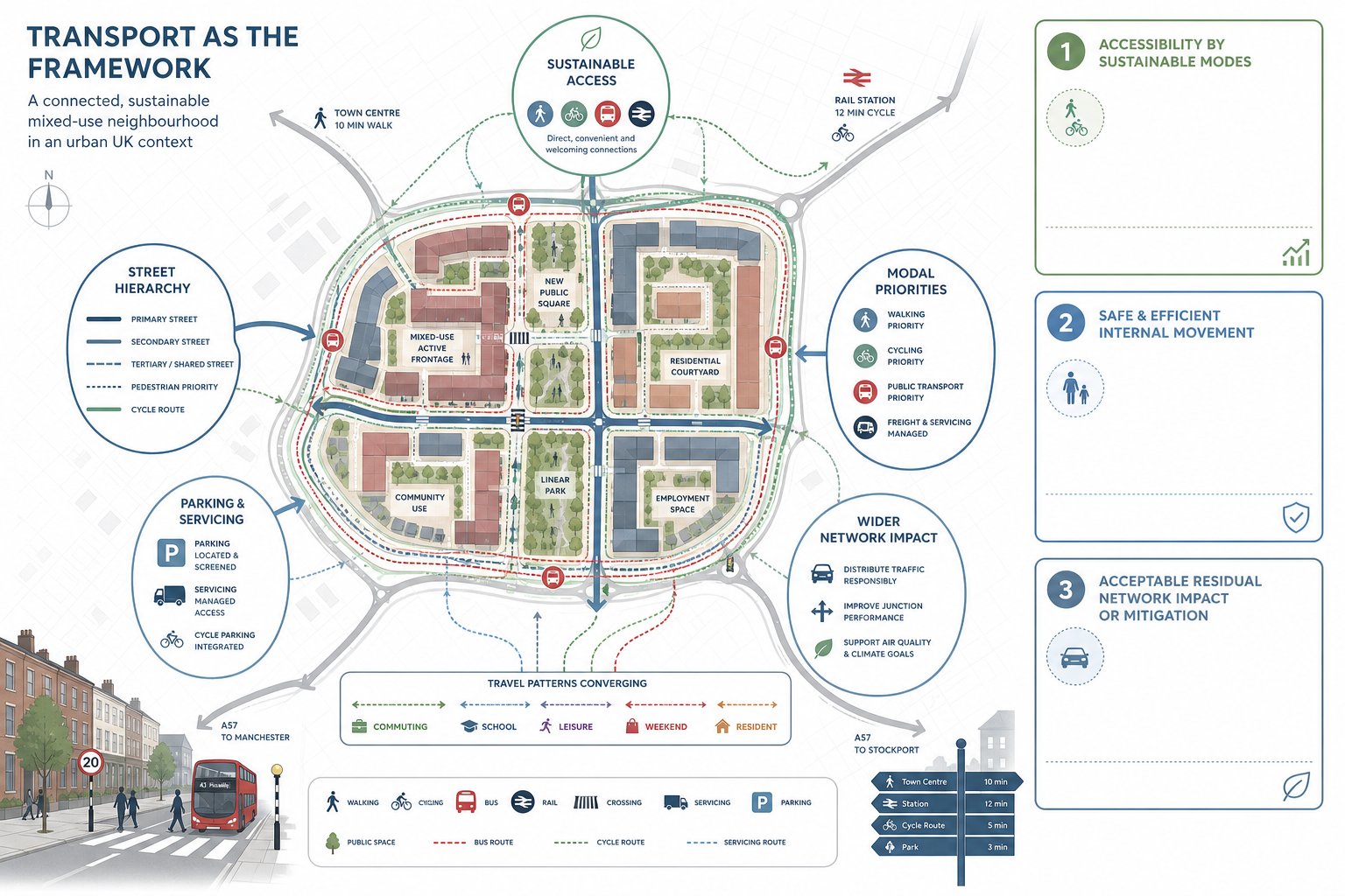
Mixed-use masterplan transport is the transport framework that sits underneath a large, often outline, planning proposal. It coordinates land use, access, street hierarchy, modal priorities, parking, servicing and network impact so the scheme can demonstrate a sustainable and policy-compliant pattern of movement.
That sounds technical because it is, but it is also spatial. Transport is not a separate appendix that appears once the design is finished. It affects block structure, frontage conditions, crossing points, where active uses sit, where bus routes can operate, how parking is distributed and whether daily trips can be made internally rather than by car.
For mixed-use schemes, this matters more than on single-use sites because the trip profile is more varied. Peak commuting flows, school-related trips, servicing windows, leisure activity, weekend footfall and resident parking demand all overlap. A credible transport strategy hence has to deal with person movement, not only vehicle movement.
In planning terms, we are usually trying to show three things at once:
- the site is accessible by sustainable modes
- the internal layout supports safe and efficient movement
- the residual impact on the wider network is acceptable, or can be mitigated
That is why transport input often needs to align with design coding, parameter plans, viability discussions and delivery strategy. On larger projects, it becomes a core part of the evidence base rather than a bolt-on report.
Why Transport Strategy Must Be Embedded At The Earliest Masterplanning Stage

The biggest transport mistake on mixed-use sites is leaving strategic movement questions until the layout already feels fixed. By that point, teams are often trying to retrofit bus penetration, cycle continuity, servicing yards or secondary access into a structure that was never designed for them.
Early transport input changes the fundamentals. It helps place density where public transport access is strongest, shape desire lines before blocks harden, and reserve enough corridor width for footways, cycle tracks, trees, utilities and servicing to coexist. It also reduces the risk of costly late-stage redesign.
We regularly find that early work on Access Strategy Transport clarifies whether a scheme should rely on one principal access, multiple points of entry, filtered routes, or phased connections tied to build-out. Those choices affect not only capacity and safety, but marketability, emergency resilience and planning confidence.
There is also a policy reason to start early. Current UK planning and design guidance increasingly expects development to prioritise walking, cycling and public transport. If those modes are only considered after the road layout is drawn, they tend to be squeezed into leftover space. And everyone notices.
A strong early strategy gives the whole consultant team something useful: a movement framework that informs design rather than chasing it.
Core Travel Demand Drivers In Mixed-Use Development
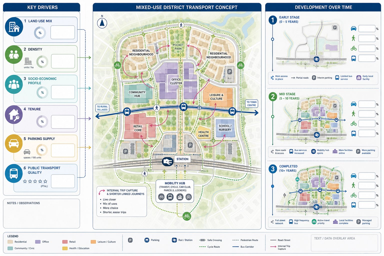
Travel demand on mixed-use sites is driven by more than raw floorspace totals. Yes, the amount of housing, employment and commercial space matters. But so do the relationships between those uses, the surrounding network, likely car ownership, parking controls, public transport quality and the timing of delivery.
Mixed-use schemes can reduce external vehicle demand because some trips are captured internally. Residents may walk to local retail, workers may use cafés on site, and community facilities can serve nearby neighbourhoods without generating long-distance movement. That internal capture is one of the major benefits of a well-composed masterplan, but it has to be evidenced carefully rather than assumed.
Density is another strong driver. Compact forms near stations or high-frequency bus corridors tend to support higher walking, cycling and public transport mode share. Lower-density schemes, especially on edge locations, often generate more car trips and longer trip lengths unless the transport offer is unusually strong.
Socio-economic profile and tenure also influence outcomes. Car ownership patterns are not the same across market housing, affordable housing, later living, student accommodation and urban build-to-rent. Nor are peak patterns identical across office, industrial, leisure and retail uses.
Parking supply and pricing can quietly reshape all of this. The transport strategy is hence not only about forecasting demand, but about designing the conditions that influence it.
How Land Use Mix, Density And Phasing Affect Movement Patterns
A scheme’s land use mix determines when people travel, why they travel and whether those trips can be linked or shortened. Homes plus local services can create daily internal walking trips. Offices plus food and convenience retail can flatten some lunchtime travel. Leisure uses may shift demand into evenings and weekends, when highway conditions differ from weekday commuter peaks.
Density changes the picture again. Higher density near good public transport usually supports frequent services, stronger footfall and more viable active travel investment. It can also justify lower car parking provision. But density without permeability, safe crossings and direct routes simply creates concentrated friction.
Phasing is where many masterplans become less elegant. Early phases often arrive before the full network, final bus service pattern or all local facilities are in place. That can mean temporary reliance on cars, different access arrangements or interim parking demand. If phasing is not considered properly, the first years of occupation can produce movement patterns very different from the completed vision.
So we need to test both the end state and the journey to it: what happens when only part of the site is built, when one access is operational, or when a mobility hub is delivered later than housing. Those details matter to planning officers and highway authorities because they affect real-world performance, not just the final illustration.
The Main Transport Principles That Shape A Strong Masterplan
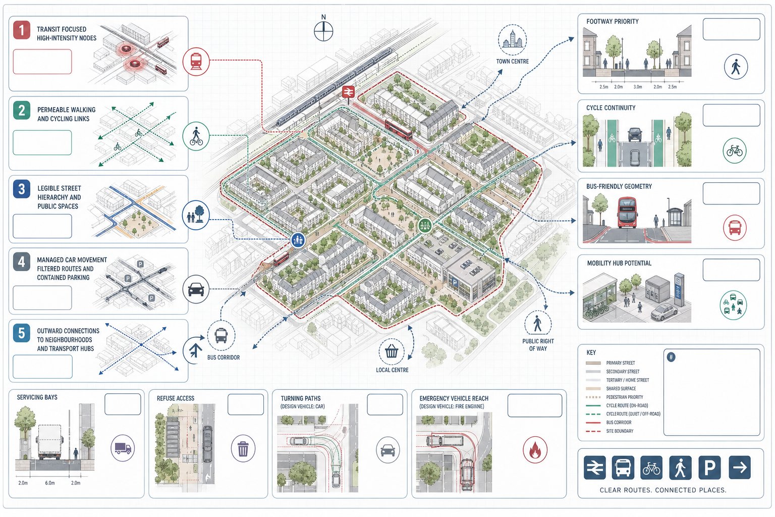
Strong mixed-use masterplans usually share a few transport principles, even when the sites themselves are very different.
First, they are transit-conscious. They place intensity near stations, key corridors or bus-ready streets and avoid dispersing trip generators into inaccessible corners. Second, they are permeable. People can move through them using more than one route, and active modes are typically given the shortest, simplest paths.
Third, they are legible. Street hierarchy, frontages, crossing points and public spaces make intuitive sense. Fourth, they manage car movement rather than letting it dominate. That does not mean cars are banned: it means carriageway width, parking location and junction design are proportionate to context.
Fifth, they connect outward as well as inward. A masterplan is not successful if it works only within the red line. It needs to stitch into surrounding neighbourhoods, transport hubs, rights of way and desire lines.
On more complex projects, these principles often sit alongside broader Private Sector Transport Planning advice, because planning risk is rarely caused by one isolated drawing. It is usually caused by inconsistencies between layout, access, policy position and evidence.
Designing Street Networks For Walking, Cycling, Public Transport And Vehicles
Street design is where transport strategy becomes visible. We generally want a network that is connected enough to distribute movement, clear enough to navigate, and calm enough to support place as well as flow.
For walking, that means wide footways where demand warrants them, frequent crossing opportunities, short waiting times, active frontages and routes that follow obvious desire lines. For cycling, continuity matters more than decorative fragments. If a route disappears at a key junction, people notice immediately.
Public transport needs streets that can physically and operationally support it: sensible geometry, stopping locations that connect to active uses, and layouts that do not trap buses behind preventable delay. On larger schemes, that may include mobility hubs or safeguarded corridors for future service enhancement.
Vehicle access still matters, of course. But right-sized carriageways, filtered permeability, low-speed environments and carefully chosen junction forms usually produce better outcomes than over-engineered roads that sever the place they are meant to serve.
Access, Servicing And Emergency Movement Requirements
Mixed-use sites do not function on resident and visitor trips alone. They need bins collected, shops stocked, plant maintained, parcels delivered and emergency services accommodated at all times.
That means access strategy has to consider swept paths, loading arrangements, vehicle waiting, turning, refuse operations and conflict points with pedestrians and cyclists. Dedicated loading bays may be essential for some uses: in other cases, timed servicing or shared facilities can reduce kerbside pressure.
Emergency movement requirements are equally important. Fire appliance access, hydrant reach, secondary routes where needed, and avoidance of dead-end vulnerabilities should all be tested early. A beautiful street hierarchy on paper can collapse quickly if the emergency geometry does not work.
The best schemes treat servicing as part of placemaking rather than an embarrassing afterthought hidden in the final week before submission.
Transport Assessments And Supporting Planning Documents For Mixed-Use Schemes
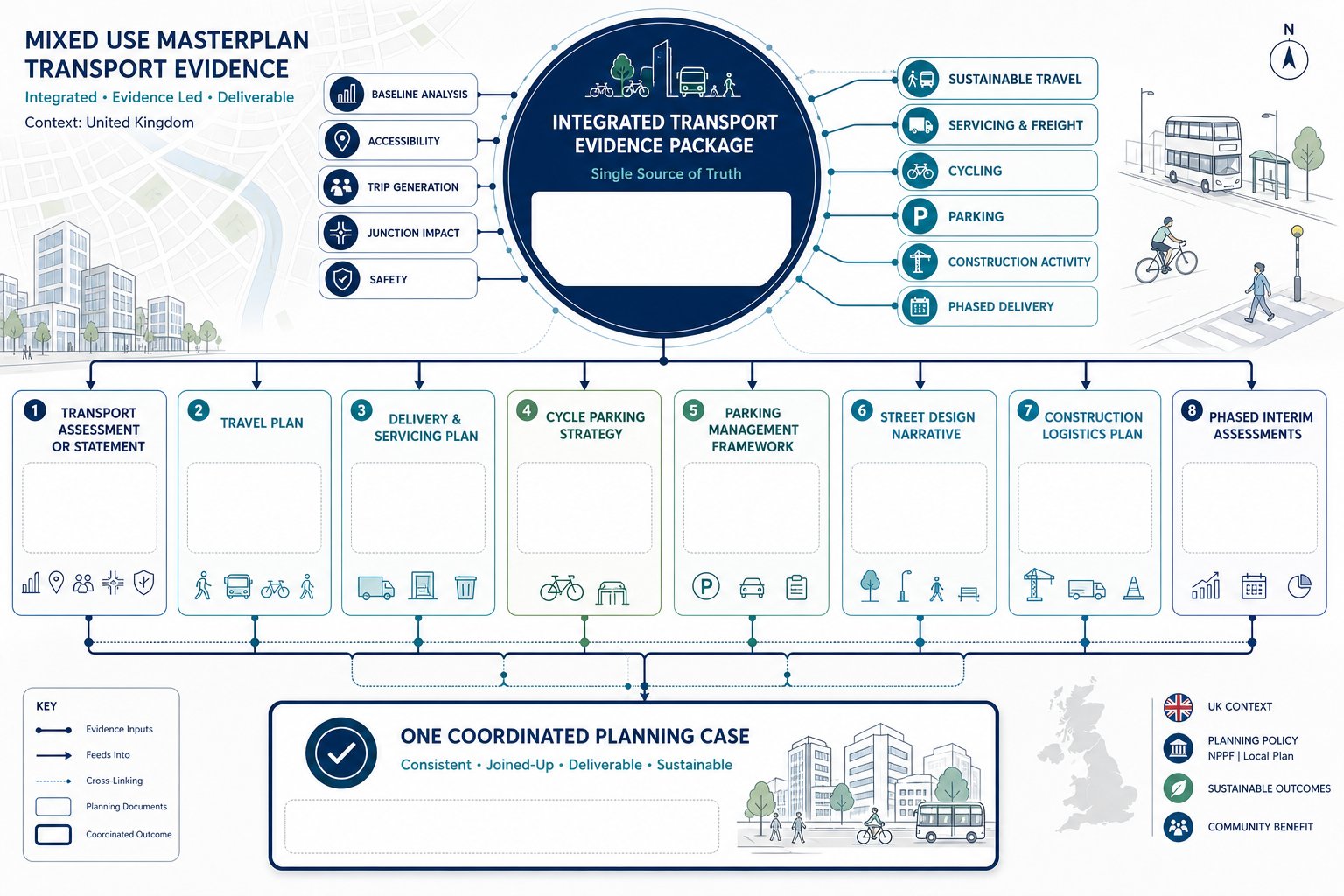
For most substantial mixed-use proposals, the transport evidence base extends well beyond a single Transport Assessment. The exact package depends on scale, use class mix, local authority thresholds and site sensitivity, but there is a fairly familiar toolkit.
A Transport Assessment or Transport Statement normally explains baseline conditions, accessibility, trip generation, distribution, junction impact, road safety context and mitigation. A Travel Plan sets out how sustainable travel will be encouraged over time, often through targets, measures, monitoring and management arrangements.
Mixed-use sites also commonly need a Delivery and Servicing Plan, cycle parking strategy, parking management framework, street design narrative and, where relevant, a Construction Logistics Plan. On phased schemes, we may also need interim assessments showing how each stage performs before the full network is complete.
The key is consistency. If the TA assumes low car mode share but the parking strategy is generous, the documents undermine each other. If the Travel Plan promises strong bus use but there is no realistic service route, consultees will spot the gap.
That is why Property Development Transport advice is often most valuable when it starts before drafting begins. The strongest submissions read as one joined-up argument, not five separate reports written in parallel.
Modelling Trip Generation, Distribution And Junction Performance
Trip modelling for mixed-use sites is part evidence, part judgement. We start with established trip-rate sources and local survey information where available, then adjust for land use context, multi-purpose trip linking, internal capture, sustainable accessibility and parking restraint.
The important point is that mixed-use development should not be assessed as a simple pile-up of standalone peak trip rates. If we do that mechanically, we can overstate some effects and miss others. Person trips, mode split and timing all matter. A foodstore, office building, residential block and gym do not all load the network in the same way, or at the same hour.
Distribution and assignment then need to reflect realistic routing choices based on network hierarchy, existing travel patterns and site access arrangements. For larger schemes, this can involve strategic models, junction modelling, queue analysis and scenario testing across different build-out stages.
Junction performance remains a central planning issue because it turns strategic debate into visible numbers: capacity, delay, reserve, queue length, practical impact. But we should not let junction modelling dominate the whole conversation. A masterplan can technically squeeze through a set of junctions while still being weak on walkability, bus penetration or street safety.
Good modelling hence supports design decisions: it should not substitute for them.
Parking Strategy, Servicing Strategy And Kerbside Management
Parking on mixed-use sites is rarely just a quantity question. It is a design, policy and operational question rolled into one. How much parking is provided, where it sits, who controls it, whether it is shared across uses, and how it interacts with active frontages all affect the success of the scheme.
In 2026, the direction of travel is fairly clear. Sites with strong public transport accessibility are generally expected to constrain private car parking, especially where that helps support mode shift and better use of land. More peripheral sites may justify higher provision, but even there, councils usually expect a stronger rationale than “people will drive”.
Cycle parking should be generous, secure, convenient and designed for actual use rather than compliance theatre. Micromobility storage, charging and visitor provision are becoming more relevant too, particularly on higher-density urban sites.
Servicing strategy needs equal attention. Retail, food and beverage, residential parcels, refuse collection, taxis and ride-hail can all compete for the same kerb space. Without management, the result is obstruction, unsafe manoeuvring and frustrated occupiers.
A good kerbside plan typically includes:
- dedicated loading where demand is regular
- timed windows for servicing activity
- clear controls for pick-up and drop-off
- short-stay visitor arrangements where appropriate
- enforcement and management responsibility
When parking and kerbside strategy are treated as one integrated system, mixed-use places work much better day to day.
Managing Delivery Phasing, Construction Traffic And Future Growth
Phasing is not just a programme issue: it is a transport risk issue. Early phases may depend on temporary accesses, reduced parking supply, interim pedestrian links or bus services that are not yet commercially viable. Unless that is planned carefully, the first phase can set poor travel habits that are hard to unwind later.
We usually advise testing transport arrangements by phase rather than relying only on the completed masterplan. That means asking practical questions. When does each access open? At what point is a secondary route needed for resilience? When is the first mobility hub delivered? Which junction upgrades are trigger-based, and what happens if occupation outpaces forecast?
Construction traffic needs its own strategy because build-out periods on mixed-use schemes can be long and disruptive. Routing agreements, compound locations, delivery timing, wheel washing, abnormal load procedures and worker parking controls all affect neighbouring streets and local acceptability.
Future growth should also be safeguarded. If a corridor may need bus priority later, do not design it so tightly that improvement becomes impossible. If adjacent land could come forward, consider whether the network can connect onward without tearing up the first phase.
The best phased transport strategies are realistic, not heroic. They acknowledge temporary compromises but make sure those compromises are controlled and reversible.
Common Risks That Delay Approval For Mixed-Use Masterplan Transport
The most common delays are surprisingly familiar.
One is underestimating trip generation or relying on optimistic mode share assumptions without enough supporting evidence. Another is weak active travel provision: routes that look acceptable on a parameter plan but fail under scrutiny because crossings are indirect, cycle links are discontinuous or surrounding connections are poor.
Over-reliance on car access is another frequent problem. That may show up as excessive parking, oversized internal roads, poor bus penetration or a layout that makes walking the slowest option. Highway authorities and planning officers increasingly recognise when a scheme says “sustainable” while drawing something else.
Junction design and road safety can also delay progress, especially where access geometry is awkward, visibility is compromised, or servicing conflicts with vulnerable road users. On larger sites, vague phasing is a serious issue too. If mitigation is promised “later” without clear triggers, trust tends to evaporate.
There is a softer risk as well: fragmented consultant coordination. When the architect, transport team, planning consultant and highways authority are effectively having different conversations, decisions drift and objections become harder to close. Many delayed applications are not undone by one fatal flaw but by a build-up of smaller inconsistencies that suggest the scheme is not yet ready.
Conclusion
A robust mixed use masterplan transport strategy is early, integrated and unapologetically practical. It should shape the masterplan from the start, not tidy it up at the end. And it has to do more than predict traffic. It needs to explain how people will move, how streets will function, how servicing will operate, how phases will be managed and why the overall pattern supports policy as well as delivery.
For teams promoting mixed-use development, that usually means keeping three priorities in balance: strong sustainable access, realistic network evidence, and operational detail that stands up under scrutiny. When those pieces align, planning discussions become sharper, design decisions become easier to defend, and the scheme has a better chance of progressing without unnecessary transport friction.
In our experience, the winning schemes are rarely the ones with the most paperwork. They are the ones where movement, access and parking were thought through early enough to become part of the place itself.
Frequently Asked Questions about Mixed Use Masterplan Transport
What does mixed use masterplan transport involve in the planning process?
Mixed use masterplan transport coordinates land uses, access points, street hierarchy, modal priorities, and parking to create a sustainable and policy-compliant movement framework supporting homes, jobs, and services.
Why is it important to embed transport strategy early in mixed use masterplanning?
Embedding transport strategy early allows land use and block layout to align with transit stations and quality walking or cycling routes, reducing car dependence, infrastructure costs, and supporting viable public transport integration.
How do land use mix, density, and phasing affect movement patterns in a mixed use development?
Compact, mixed-use areas near transit encourage walking, cycling, and public transport trips while reducing car trips. Phasing must ensure network capacity and transit services develop alongside the scheme.
What are the main transport principles shaping an effective mixed use masterplan?
Key principles include transit-oriented design, street permeability and legibility, safe and direct active travel routes, managed car access and parking, and integration with wider transport networks and hubs.
How should parking and servicing be managed in mixed use masterplan transport?
Parking should be constrained near transit with generous, secure cycle parking. Servicing requires dedicated loading bays, timed windows, and managed kerbspace to prevent conflicts and support smooth deliveries and pickups.
What common issues cause delays in approval of mixed use masterplan transport strategies?
Delays often arise from underestimating trip generation, insufficient active travel provision, excessive reliance on car access, poor junction or safety design, and weak phasing or construction traffic management.