Canterbury is one of those places where transport planning looks simple on a map and becomes complicated the moment you zoom in. A compact historic centre, narrow streets, major education sites, commuter movements, tourism, freight, edge-of-city growth and a strong policy push towards walking, cycling and public transport all pull in different directions at once. For developers and local authorities, that means transport evidence has to do more than count cars. It has to show that a scheme can work in a constrained network, align with local policy and support the wider direction of travel for the district.
In 2026, Transport Planning in Canterbury sits squarely within the framework of the Canterbury District Local Plan, the Draft Canterbury District Transport Strategy to 2042/43, Kent County Council’s transport role as highway authority, and the familiar national tests around severe impact, accessibility and sustainable development. In practice, we’re usually dealing with a sharper question: will this proposal make movement in Canterbury better, worse, or simply more difficult to manage?
That’s why early, locally informed transport input matters. Whether we’re advising on housing, student accommodation, retail, employment or mixed-use proposals, the strongest planning applications tend to be the ones that anticipate Canterbury’s constraints from the start rather than trying to explain them away later.
Why Transport Planning Matters For Canterbury Developments
Transport planning matters in Canterbury because growth is rarely judged on land use alone. A development may be acceptable in principle, but if access is poor, junction impacts are unclear, bus links are weak, or walking and cycling connections feel tokenistic, planning risk rises quickly.
The district’s policy direction is clear enough. Growth needs to support housing and jobs while also managing congestion, carbon emissions and air quality. That’s especially important in Canterbury, where the network is sensitive and the city centre cannot simply absorb more traffic forever. In other words, transport is not a side report. It often becomes one of the main tests of whether development is deliverable.
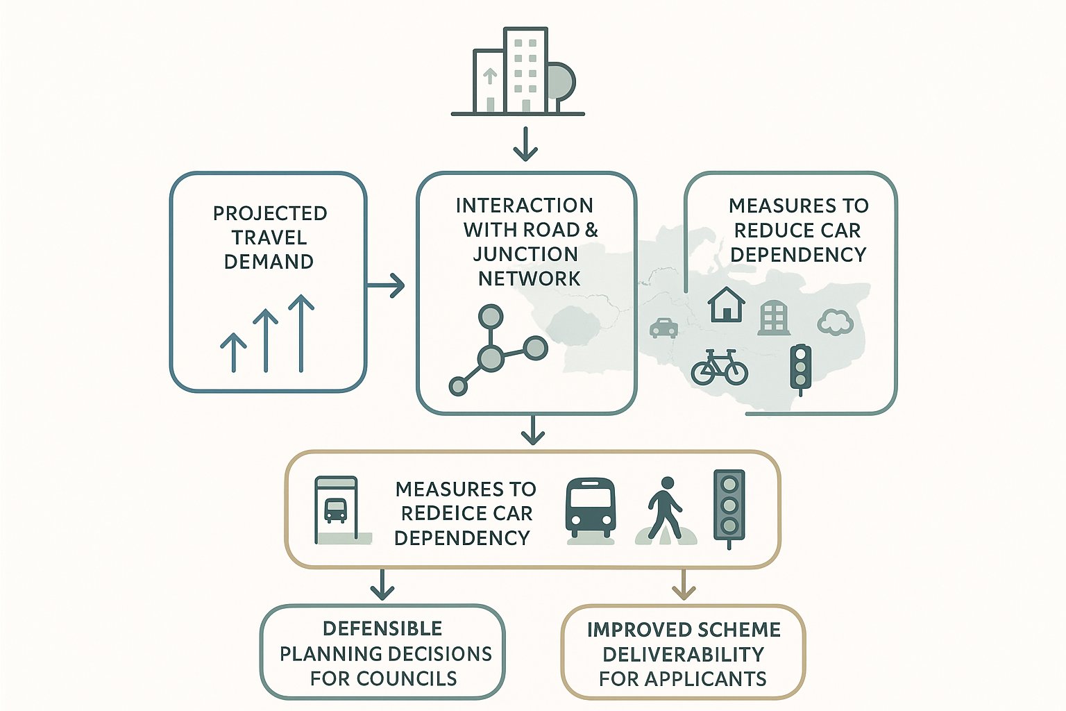
For applicants, good transport planning helps us demonstrate three things early: first, what travel demand a site is likely to create: second, how that demand interacts with the surrounding network: and third, what realistic measures can reduce car dependency. That might mean improved pedestrian links, cycle parking, bus stop upgrades, travel planning, servicing controls, parking restraint or junction improvements. Often it’s a combination.
For councils, transport evidence supports defensible decision-making. It helps planning officers and members understand whether impacts are acceptable, whether mitigation is proportionate, and whether a scheme genuinely supports local movement objectives rather than adding pressure to known trouble spots. In Canterbury, that’s not academic. It’s central to planning outcomes.
The Planning And Transport Context In Canterbury
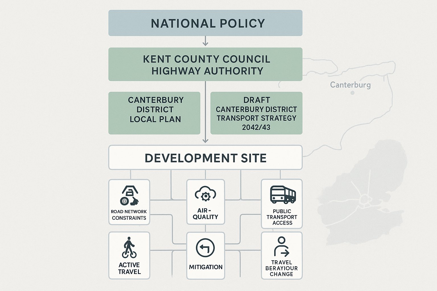
The planning and transport context in Canterbury is shaped by a layered policy structure. At district level, the Canterbury District Local Plan sets the development framework, including movement and transport policies that influence site allocation, access design, parking, sustainable travel and mitigation. Alongside that, the Draft Canterbury District Transport Strategy to 2042/43 sets out a longer-term direction for managing growth and changing travel behaviour across the district.
Then there is Kent County Council, acting as local highway authority. That matters because highway and transport responses to planning applications are filtered through county-level standards, evidence expectations and local transport strategy considerations. National policy still sits above all of this, but the local context usually determines what a robust submission actually looks like.
What we see in practice is that Canterbury schemes are rarely assessed in isolation. Officers will want to know how a proposal relates to committed developments, known network constraints, active travel ambitions, public transport accessibility and air quality concerns. The strongest reports connect those threads instead of treating them as separate technical boxes.
This is also where local experience helps. A concise report is useful only if it answers the authority’s real questions. On projects across Kent, we’ve found that speed alone is never enough: transport evidence has to be tailored to the local thresholds, sensitivities and policy wording that decision-makers are working with.
How Canterbury’s Historic Street Network Shapes Transport Strategy
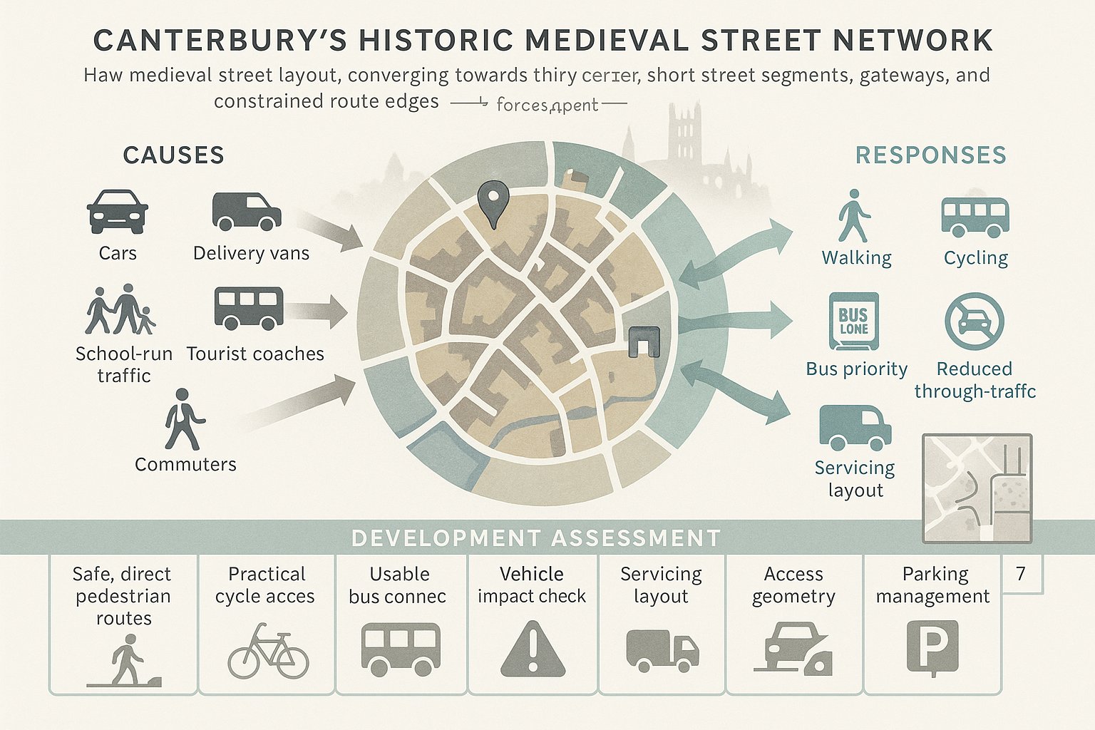
Canterbury’s historic street pattern is not a minor backdrop: it drives transport strategy. The medieval core was not designed for modern traffic volumes, large delivery vehicles, peak-period school runs, tourist coaches and everyday commuter movement all competing for space. Narrow carriageways, constrained junctions, short visibility in places and limited opportunities to widen routes mean conventional capacity-led solutions are often unrealistic.
That physical constraint is one reason local strategy leans heavily towards walking, cycling, bus priority and a reduction in unnecessary through-traffic in the city centre. Put bluntly, the city cannot build its way out of congestion in the traditional sense. It has to manage demand and rebalance street space.
For development proposals, this changes the emphasis of a transport assessment. We still need to understand vehicle impacts, of course. But we also need to demonstrate how people can reach the site without driving, whether pedestrian routes are genuinely direct and safe, how cycle access works in practice, and whether bus services are usable enough to support mode shift.
It also means small design choices matter more in Canterbury than they might on a less constrained network. A poor servicing arrangement, an awkward access geometry, or a parking strategy that encourages avoidable car trips can have an outsized effect when the surrounding streets already operate with very little slack.
When A Transport Assessment Or Transport Statement Is Needed
A Transport Assessment or Transport Statement is generally needed where a proposal is likely to have a material impact on movement. The exact threshold depends on scale, land use, location and sensitivity, but larger residential schemes, retail development, education uses, employment floorspace, healthcare sites and mixed-use proposals commonly trigger transport input.
In Canterbury, location can be just as important as size. A relatively modest scheme near the historic core, within an Air Quality Management Area, close to constrained junctions, or in a place with difficult servicing arrangements may need more evidence than a larger proposal in a less sensitive setting. That’s why relying on generic national thresholds alone can be risky.
As a rule, a Transport Statement is more appropriate where impacts are expected to be limited and straightforward to explain. A full Transport Assessment is usually required where trip generation is higher, junction effects are uncertain, mitigation is needed, or there are wider questions around sustainable access, cumulative impact or policy compliance.
Early scoping is the smart move. Before design has hardened, we should be asking: what is the highway authority likely to want tested, what survey data will be needed, what committed development should be included, and are there local issues such as school traffic, seasonal peaks or parking displacement that could become objections later? Getting that answer early can save months.
What A Canterbury Transport Assessment Typically Covers
A Canterbury Transport Assessment typically needs to do more than provide traffic diagrams and a few junction outputs. It should explain the policy context, describe baseline conditions, quantify travel demand, assess effects on the surrounding network and set out a credible package of mitigation and sustainable transport measures.
At minimum, we would expect to cover site location, existing access conditions, nearby walking, cycling and public transport infrastructure, collision history where relevant, parking context, servicing arrangements and the relationship to local and committed development. The report should also be explicit about the assessment years and why they are appropriate.
Policy alignment matters throughout. Decision-makers will expect the assessment to show how the scheme responds to the Canterbury District Local Plan, the emerging district transport strategy, Kent requirements and national planning policy. In Canterbury particularly, a weak policy narrative can undermine even technically competent modelling.
Mitigation should be practical rather than aspirational. If the scheme depends on mode shift, we need to show how that shift is supported. If a junction improvement is proposed, it has to be deliverable. If parking is restrained, there should be a coherent explanation of how overspill will be managed. Good assessments join evidence, design and policy into one argument, not three separate appendices.
Trip Generation, Distribution And Junction Impact
Trip generation is often where scrutiny begins. We need robust estimates of both vehicle trips and person trips, derived from suitable comparable sites, local census or travel behaviour evidence, and realistic assumptions about mode share. In Canterbury, using generic suburban comparators for a central or highly accessible site can quickly weaken credibility.
Distribution and assignment come next. It’s not enough to know how many trips are generated: we need to understand where they will go and which links and junctions they will affect. That usually means building a reasoned distribution pattern based on local travel attractors, strategic routes, existing turning data and the characteristics of the site.
Junction impact testing should focus on the locations that genuinely matter, including known congestion hotspots and sensitive nodes identified through local evidence. Depending on the proposal, that might involve priority junction modelling, signal modelling, roundabout assessment or microsimulation. But the software is only part of the job. The important question is whether the assumptions reflect how Canterbury actually operates.
And there’s a practical point here: authorities are often more persuaded by transparent, well-explained assumptions than by black-box complexity. If trip rates, growth factors, distribution and committed development have been selected carefully and justified clearly, the resulting assessment is far easier to defend during consultation and, if necessary, at appeal.
Active Travel, Public Transport And Accessibility Requirements
Canterbury places real weight on sustainable access. That means active travel and public transport are not optional extras to bolt on after the traffic work is finished: they are core to how a scheme is judged.
For walking and cycling, the test is practical usability. Are routes direct, legible and safe? Do they connect to the city centre, schools, universities, local centres and surrounding neighbourhoods without awkward detours? Is cycle parking secure, covered and convenient? Are crossings in the right place, or simply drawn on a plan because they looked neat? These details affect whether people actually change travel habits.
Public transport matters too, especially for larger residential, student and employment schemes. We need to demonstrate realistic access to bus corridors and, where relevant, rail stations. Frequency, journey time, service span and walking distance all count. A bus stop technically nearby but difficult to reach, poorly lit or lightly served may not carry much weight.
Accessibility analysis should show what people can reach and how. In Canterbury, that often means considering education sites, the historic centre, employment areas and healthcare destinations. Where mode shift is part of the planning case, a travel plan should back it up with specific measures, monitoring and review mechanisms. Vague promises about encouraging sustainable travel won’t get far anymore.
Key Local Factors That Can Affect Planning Approval
Several local factors can materially affect planning outcomes in Canterbury, even where headline traffic numbers appear manageable.
First, congestion hotspots matter. If a scheme adds pressure to already stressed corridors or junctions, officers will want to know whether the increase is noticeable, whether queues could spill back to affect wider movement, and whether any mitigation is realistic. In a constrained urban network, relatively small additions can become contentious.
Second, air quality remains an important consideration, particularly around the city centre and other sensitive corridors. Development that appears to encourage unnecessary vehicle movement, idling or poor routing can face sharper scrutiny where air quality concerns already exist.
Third, the quality of sustainable transport provision is increasingly decisive. A scheme that technically passes a capacity test but offers weak pedestrian links, poor cycle access or little meaningful public transport integration may still struggle because it conflicts with the wider local direction of travel.
There is also a broader strategic point. Canterbury’s emerging transport approach is not simply predict-and-provide: it is closer to a vision-led or vision-and-validate model, where development should support the future network the district wants, not just fit within old travel patterns. That changes the tone of transport planning. We are not only asking, “Can cars get in and out?” We are also asking, “Does this scheme help move Canterbury in the right direction?”
Common Development Types That Need Transport Input
Some development types almost always benefit from early transport input in Canterbury.
Strategic housing and urban extensions are the obvious examples. They generate multi-directional travel demand, raise questions about school access, bus service viability, phased mitigation and cumulative impact, and often require a broader movement strategy rather than a single-site fix.
Student accommodation is another key category. Canterbury’s higher education presence makes this locally significant. Student schemes may have lower car ownership than mainstream housing, but they still need careful work around servicing, arrivals and departures, coach activity, active travel demand and links to campus and the city centre.
Retail, leisure and town-centre uses can be sensitive because trip timing, parking demand, servicing and pedestrian interaction are often more important than gross floorspace alone would suggest. A site can be central and still function poorly if deliveries and customer access are not thought through.
Employment, industrial and business park development often requires a different lens: staff mode share, shift patterns, freight, HGV routing, access geometry and operational safety. Education and healthcare facilities also regularly need transport evidence because of peak concentration, safeguarding concerns and the way short-duration trips can affect local streets.
In short, if a scheme changes how people or goods move at a noticeable scale, transport planning should start early rather than halfway through a planning submission.
Typical Transport Planning Risks And How To Avoid Delays
The most common transport planning risk is underestimating how much evidence a Canterbury site will need. Teams sometimes assume a proposal is too small for detailed work, only to discover late in the process that the authority wants surveys, junction testing, swept paths, parking analysis, a travel plan and policy justification. By then, programme pressure has usually crept in.
Another frequent problem is relying on weak assumptions. Over-optimistic mode share, selective comparator sites, outdated traffic data or vague distribution patterns can all lead to objections. Once credibility slips, even sensible conclusions become harder to defend.
Late engagement is a third risk. If Kent County Council and the local planning authority are brought in only after the layout is fixed, opportunities to resolve concerns cheaply may already be gone. Early discussion about scope, methodology and likely pressure points can save redesign work later.
Mitigation can also be mishandled. Some applications identify impacts but offer responses that are either too generic, not clearly deliverable, or detached from local strategy. In Canterbury, mitigation needs to support sustainable travel goals as well as address direct network effects.
The best way to avoid delay is simple, if not always glamorous: scope early, use recent evidence, be realistic about constraints, and make sure the transport narrative matches the planning narrative. When those pieces align, consultation tends to be faster and less combative.
How To Prepare Strong Evidence For A Planning Application
Strong transport evidence starts with a clear strategy. Before writing a report, we need to understand what the application is trying to prove, what the likely transport objections are, and which policies the scheme must satisfy. In Canterbury, that usually means addressing movement and transport policies in the Local Plan, responding to the direction of the Draft Canterbury District Transport Strategy, and showing that the proposal supports sustainable, safe and accessible travel.
The evidence base should be current and proportionate. That may include traffic counts, queue surveys, pedestrian and cycle observations, parking beat surveys, personal injury collision data, public transport information and accessibility analysis. For larger schemes, we should also consider committed development, future year scenarios and realistic sensitivity testing. The key word is realistic. Authorities are unlikely to be persuaded by a best-case world that nobody expects to happen.
Presentation matters as well. A strong assessment is easy to follow. It explains assumptions, justifies data sources, maps trip routes clearly and links impacts to mitigation in a way non-transport readers can understand. Planning officers, lawyers, committee members and local stakeholders all need to see the logic.
Where appropriate, it helps to combine technical rigour with speed and local tailoring. That is exactly where experienced transport consultants add value: producing concise, accurate reporting that speaks to authority expectations rather than drowning the application in unnecessary volume. Good evidence does not just answer questions. It reduces the number of new ones.
Conclusion
Transport planning in Canterbury is rarely routine. The city’s historic form, constrained network, air quality concerns and strong policy emphasis on sustainable movement mean planning applications need transport evidence that is local, credible and forward-looking.
For developers, designers and councils, the message in 2026 is straightforward: treat transport as part of the scheme strategy from day one. Identify whether a Transport Statement or full Transport Assessment is needed, scope the work early, test realistic assumptions and build mitigation around how Canterbury actually functions rather than how we might wish it functioned.
The best outcomes usually come from evidence that is concise, policy-led and tailored to local authority expectations. That means showing not only that impacts are understood, but that the proposal contributes to a better pattern of movement across the district. In Canterbury, that is often the difference between a report that merely accompanies an application and one that actively helps secure permission.
Frequently Asked Questions about Transport Planning in Canterbury
Why is transport planning especially important for developments in Canterbury?
Transport planning in Canterbury is vital because growth impacts go beyond land use. Developments must manage access, congestion, air quality, and support sustainable travel modes in a constrained historic network, ensuring schemes align with local policies and deliverable movement improvements.
What policies shape transport planning decisions in Canterbury?
Canterbury transport planning follows the Canterbury District Local Plan, the Draft Canterbury District Transport Strategy to 2042/43, Kent County Council’s highway authority standards, and national planning policies, creating a layered framework for assessing development impacts and sustainable travel.
How does Canterbury’s historic street network influence transport strategy?
The compact medieval core with narrow streets restricts vehicle capacity, making conventional road expansion impractical. This leads to strategies prioritising walking, cycling, bus priority, and reducing through-traffic to manage congestion and improve sustainable travel accessibility.
When is a Transport Assessment or Transport Statement required in Canterbury?
A Transport Assessment or Statement is needed for developments likely to materially affect traffic, such as large residential, retail, education, employment or mixed-use proposals. Sensitive locations like the historic centre, Air Quality Management Areas, or constrained junctions often require detailed assessments.
What key elements should a Transport Assessment in Canterbury include?
It should cover compliance with local and national policies, baseline traffic and accessibility conditions, trip generation and distribution, junction impact, and a practical mitigation package promoting sustainable travel. The assessment horizon aligns with the Local Plan period and committed developments.
How can developers ensure strong transport evidence to support planning applications in Canterbury?
Early scoping with local authorities, using current and robust multimodal data, realistic mode shift assumptions, clear policy alignment, concise reporting, and credible, deliverable mitigation measures tailored to Canterbury’s transport context help avoid delays and improve application success.