Portsmouth can be a tricky place to get transport right. It’s a dense island city, the road network is heavily constrained, parking pressure is real, and air quality remains a live planning issue. So when a development proposal lands on a case officer’s desk, transport planning is rarely a box-ticking exercise. It often becomes one of the main factors in whether an application moves forward smoothly or gets bogged down in questions, revisions and delay.
That’s exactly why Transport Planning in Portsmouth needs a locally informed approach. The city’s planning decisions are shaped by Portsmouth City Council’s transport priorities, especially the direction set by Local Transport Plan 4, which pushes hard towards walking, cycling and public transport while managing congestion and supporting growth. In practice, that means developers need more than a generic report. They need evidence that is proportionate, defensible and tailored to Portsmouth’s streets, junctions and policy context.
In this guide, we set out what architects, planners, surveyors, solicitors, developers and local authorities need to know for 2026. We cover when a Transport Statement, Transport Assessment or Travel Plan is likely to be needed, the highways issues usually scrutinised by the council, and the common mistakes that slow applications down. We also explain what a robust transport planning package looks like in Portsmouth, the sort of practical, concise evidence base that helps schemes stand up to review and progress with fewer surprises.
Why Transport Planning Matters In Portsmouth
Portsmouth is not a city where highway impacts can be treated lightly. Its geography does most of the explaining: a compact island setting, limited routes in and out, constrained junctions, intense competition for street space, and neighbourhoods where walking, cycling, buses, servicing, resident parking and through traffic all collide.
That creates a planning environment in which transport evidence carries real weight. A scheme that might appear modest in another authority area can still attract scrutiny in Portsmouth if it adds turning movements at a sensitive junction, increases parking stress on surrounding streets, or fails to support sustainable travel choices.
Portsmouth City Council’s wider transport strategy is also important here. Through Local Transport Plan 4, the city is aiming to improve connectivity, reduce car dependency, tackle poor air quality and support healthier travel behaviour. Those goals feed directly into development management. In other words, the council is not just asking whether vehicles can technically get in and out of a site. It is asking whether the proposal supports the city’s long-term transport direction.
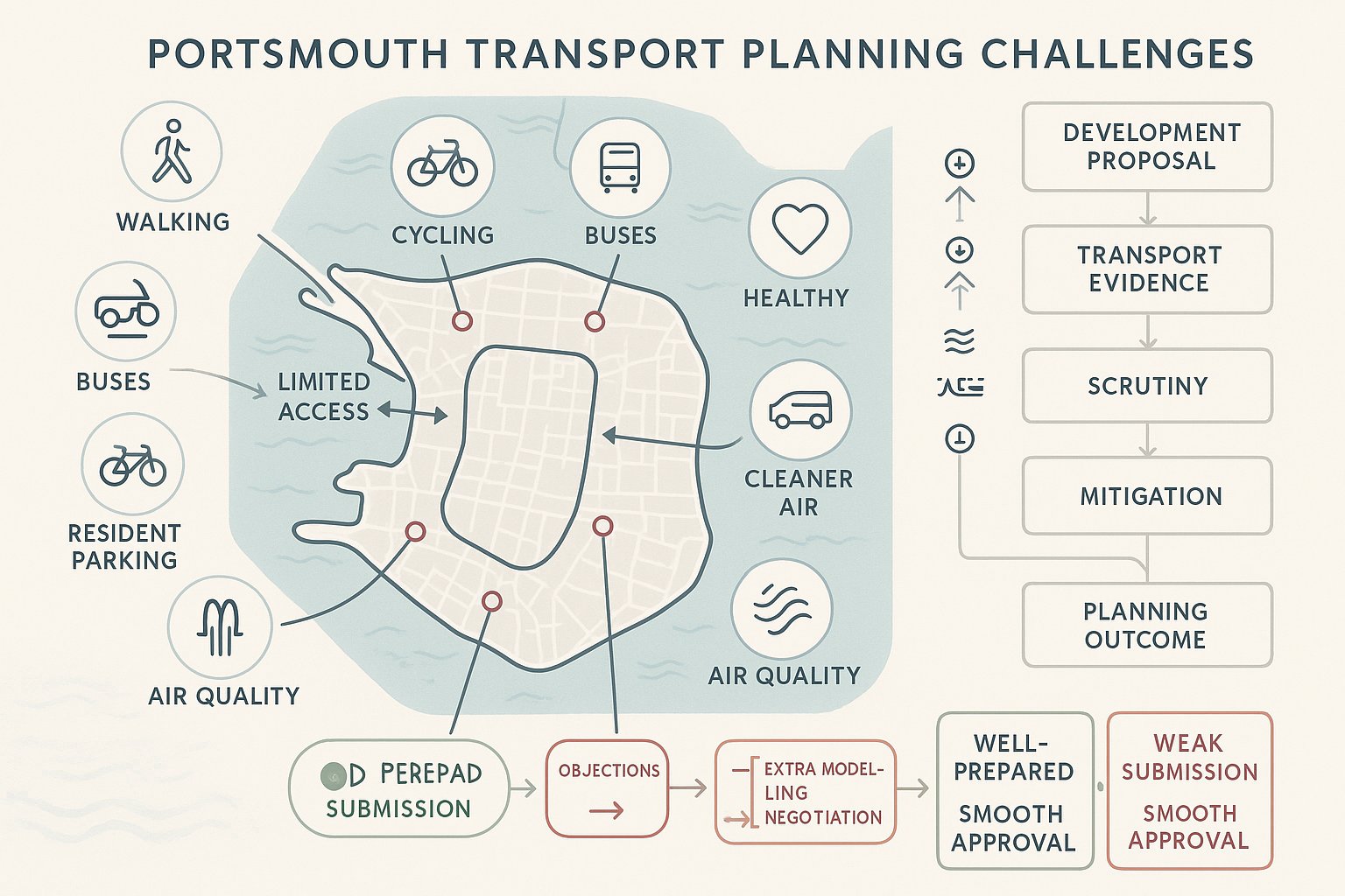
For developers, that means transport planning is often central to planning risk. A well-prepared submission can demonstrate that access is safe, impacts are acceptable and mitigation is credible. A weak one can trigger objections, additional modelling requests, delayed validation or awkward negotiation late in the process.
Portsmouth’s Local Transport Context And Planning Constraints
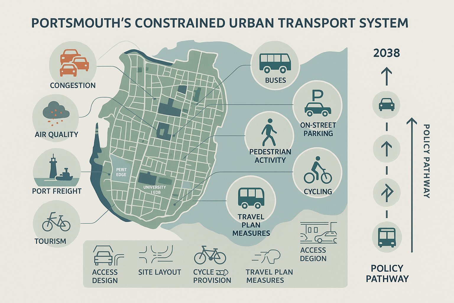
To understand transport planning in Portsmouth, we first need to understand the city itself. Portsmouth is unusually constrained physically. There is very limited room for major highway expansion, many routes already operate under pressure, and several locations experience recurring congestion at peak times. Add in high urban density, strong pedestrian activity, a major university presence, tourism, port-related movement and district shopping centres, and the network becomes finely balanced.
Policy reflects that reality. Portsmouth City Council’s Local Transport Plan 4 sets a clear direction to 2038: more trips by walking, cycling and public transport, better connectivity, improved health outcomes and reduced environmental harm. That is not a side note. It shapes expectations for site layout, parking restraint, cycle provision, access design and Travel Plan measures.
There are practical constraints too. Some streets have narrow frontages, restricted visibility, extensive on-street parking or frequent bus movements. In central and more urban areas, a development may be expected to function with lower car reliance than it would elsewhere. Air Quality Management concerns can also influence how trip impacts and mitigation are considered.
So context matters. A transport strategy that ignores Portsmouth’s compact urban form or assumes abundant highway capacity is unlikely to persuade. The strongest submissions respond directly to local conditions, not generic national assumptions.
How Development Type And Scale Affect Transport Requirements
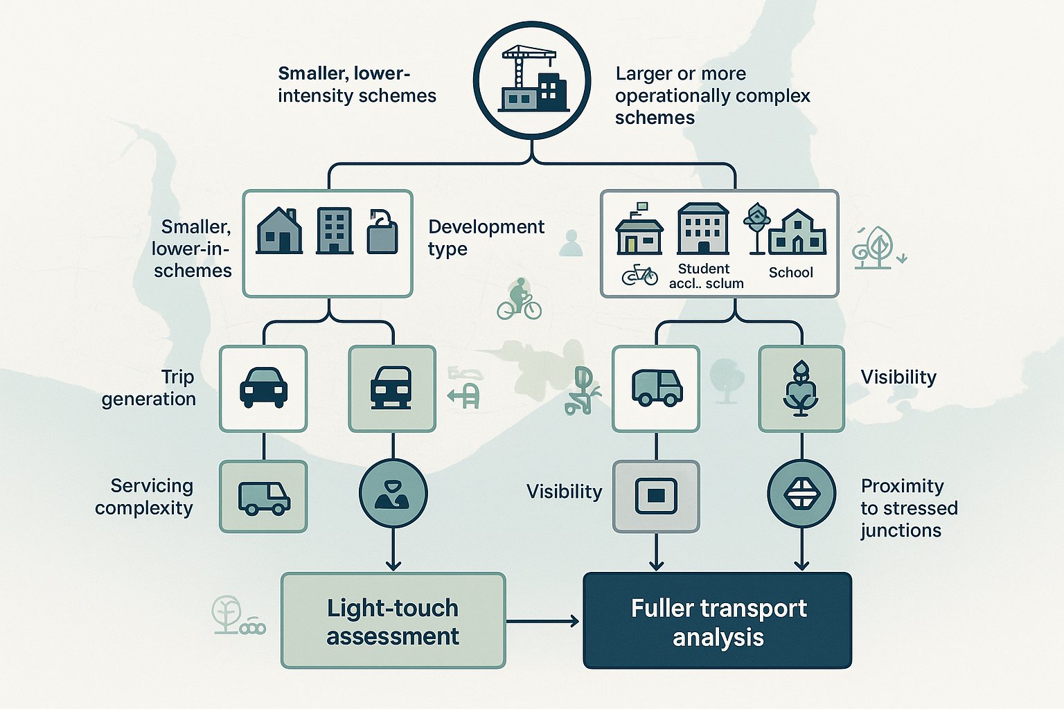
Not every proposal needs the same depth of transport evidence. In Portsmouth, the likely level of scrutiny depends heavily on both what is being proposed and how large or intensive it will be.
A small infill housing scheme, a modest office fit-out or a low-key change of use may only create limited additional trips. In those cases, a concise assessment may be enough, provided access, parking and servicing are straightforward. But once a scheme begins to generate more activity, more arrivals, departures, deliveries, refuse collection, pick-up and drop-off, or peak-time pressure, transport requirements usually become more detailed.
Some land uses tend to attract particular attention. Food retail, drive-thrus, student accommodation, HMOs, larger residential developments, schools, employment sites and leisure or stadium-related uses can all produce trip patterns that are more intense, more concentrated at specific times, or more operationally complex. A site near already-stressed junctions may also need fuller analysis even if the floor area looks relatively modest on paper.
Scale is only part of it. The pattern of movement matters just as much. A scheme with few daily trips but awkward servicing, poor visibility or high on-street parking demand can raise more concern than a slightly larger development with excellent sustainable links and clean internal layout.
That’s why we usually advise developers to assess likely transport effects early, before design assumptions harden. It’s much easier to solve a transport problem at concept stage than after submission.
When A Transport Statement, Transport Assessment, Or Travel Plan Is Needed
The key question is proportionality. Planning authorities generally expect transport submissions to match the likely scale and significance of impact.
A Transport Statement is typically used for smaller schemes where transport effects are expected to be limited. That might include minor residential development, a smaller change of use or redevelopment where trip increases are modest and there is no strong evidence of severe network consequences. A good Transport Statement still needs to be evidence-based: “small scheme” does not mean “light on justification”.
A Transport Assessment is usually needed for major development or proposals that could materially affect traffic patterns, junction performance, safety, servicing or sustainable access. If a scheme is likely to alter queuing, increase turning movements at constrained junctions, intensify use of a difficult access, or create meaningful cumulative impact, a fuller TA is often the right route.
A Travel Plan is commonly required where there is a realistic opportunity, and policy expectation, to influence how people travel. Schools, larger workplaces, student accommodation, higher-density residential schemes and other trip-generating uses often fall into this category. The purpose is not just to say sustainable travel is desirable: it is to set out measures, targets and monitoring that make mode shift credible.
In Portsmouth, these judgments are best discussed early with the council. Local thresholds, site sensitivities and surrounding network conditions can all affect whether a TS, TA or Travel Plan is considered necessary.
Typical Highways And Access Issues Reviewed By The Council
Portsmouth City Council will usually review whether a development offers safe and suitable access for all users, whether its highway effects are acceptable, and whether its design supports the city’s wider sustainable transport objectives. That broad test then breaks down into some very practical questions.
Is the access geometry appropriate? Will vehicles be able to enter and leave safely? Does the proposal create conflict with pedestrians or cyclists? Is there enough operational space on site for deliveries, refuse and emergency access? Will overspill parking worsen conditions on nearby streets? Are nearby junctions already under stress? And does the layout genuinely support non-car travel, or simply mention it?
This is where transport planning becomes very site-specific. The council will often look beyond headline numbers and focus on how the scheme actually functions day to day. A development can fail not because traffic generation is extraordinary, but because one awkward crossover, one blocked servicing arrangement or one badly located bin collection point causes repeated conflict on the public highway.
The most robust submissions anticipate those concerns rather than waiting for them to be raised in consultation.
Vehicle Access, Visibility, And Servicing Considerations
Access design is often the first transport issue people think about, and for good reason. If vehicles cannot safely and efficiently reach the site, the rest of the planning case becomes harder to defend.
In Portsmouth, councils and highway officers will usually expect access arrangements to align with the principles in Manual for Streets and other relevant Department for Transport guidance. That means suitable visibility splays, sensible junction geometry, safe spacing from nearby accesses or junctions, and layouts that reflect actual street conditions rather than idealised drawings.
Servicing is just as important. Delivery vans, refuse vehicles and, in some cases, larger rigid vehicles need a workable strategy. Can they stop without obstructing traffic? Is there enough turning space? Do vehicles need to reverse onto the highway? Can emergency access be maintained? These are not minor technical points. They often sit right at the heart of planning negotiations.
Swept-path analysis is frequently needed to prove that the proposed layout works in practice. And if forward gear entry or exit is expected, the design needs to show it clearly. In dense urban locations, even a small weakness in servicing logic can draw challenge because the surrounding street network has very little spare tolerance for bad manoeuvres.
Walking, Cycling, Public Transport, And Sustainable Travel Expectations
Portsmouth’s policy direction is clear: development should support a stronger sustainable mode share, not reinforce avoidable car dependence. That means the council is likely to look closely at how a site connects to walking routes, cycle infrastructure and public transport services.
For pedestrians, the basics matter. Are routes direct, legible, well lit and overlooked? Do they connect naturally to the surrounding network? Are crossings safe and convenient? For cycling, secure and usable parking is only part of the picture: access to and from the highway has to feel practical for everyday use.
Public transport accessibility also matters, particularly for higher-density residential, student and employment uses. Reasonable walking distances to bus stops, safe footway links and a decent waiting environment can all strengthen the case that car reliance will be lower. In some locations, developers may also need to consider travel information packs, car club provision, low-car or car-free arrangements, EV charging and incentives that encourage residents or staff to choose alternatives.
And here’s the key point: sustainable travel measures need to be designed in, not bolted on. A scheme that offers token cycle spaces but poor site permeability or awkward pedestrian access will not feel convincing.
Parking, Cycle Storage, And Operational Layout Expectations
Parking is often one of the most sensitive transport topics in Portsmouth. The city has areas of acute on-street pressure, but it also has strong policy reasons for avoiding excessive car provision, especially in accessible urban locations. So the right answer is rarely “more spaces by default”. It is usually a carefully evidenced balance.
Developments should align with local parking expectations while recognising the council’s broader air quality and modal shift objectives. In central or well-connected areas, restrained parking provision may be appropriate, but only if the wider transport strategy genuinely supports it. If reduced car parking is proposed, the submission should explain why that is realistic and how impacts will be managed.
Cycle storage is no longer an afterthought. The expectation is usually for secure, covered, convenient and step-free cycle parking that people will actually use. Resident, staff and visitor needs may all need to be addressed separately.
Operational layout matters too. Internal circulation should be clear. Loading, servicing, refuse collection and emergency access should work without conflict. Parking courts should not dominate the public face of the site if better design options exist. In short, the site should function cleanly from arrival to departure, not just look compliant on a plan.
The Role Of Traffic Surveys, Trip Generation, And Junction Capacity Testing
Transport evidence is only persuasive if the baseline is sound. That is why traffic surveys, trip generation and junction modelling remain central to many Portsmouth planning applications.
Surveys establish what is happening on the network now. Depending on the scheme, that may include weekday AM and PM peak turning counts, queue observations, automatic traffic counts, parking beat surveys, pedestrian and cycle counts, or weekend surveys where retail or leisure uses are involved. Timing matters: outdated or unrepresentative data can quickly weaken a submission.
Trip generation then estimates how many movements the development is likely to create. In most cases, that will involve TRICS evidence, carefully selected and sensibly adjusted where local context justifies it. The crucial thing is transparency. If assumptions are optimistic, unexplained or detached from Portsmouth conditions, they are likely to be challenged.
Where a scheme affects key junctions, capacity testing may be needed using tools such as PICADY, ARCADY or LINSIG. The aim is not just to model the development in isolation, but to test operation with and without development, and often with relevant committed schemes included. Done properly, this helps answer the question decision-makers actually care about: will the local network continue to operate acceptably, or are mitigation measures required?
How Transport Evidence Supports Planning Applications
Good transport evidence does far more than satisfy a validation requirement. It helps build the planning case.
At national level, the familiar test is whether there would be safe and suitable access for all users, and whether the residual cumulative impacts on the road network would be severe. Local transport reporting is what allows a planning authority to make that judgment with confidence.
A clear, proportionate TS or TA can demonstrate that a site is accessible, that expected trip effects have been properly assessed, that junction impacts are understood, and that mitigation is either unnecessary or deliverable. A robust Travel Plan can show how mode shift will be supported in practice. Technical drawings can prove that servicing, refuse collection, turning and cycle provision actually work on the ground.
This evidence also gives shape to planning conditions and obligations. Travel Plan monitoring, access works, construction traffic management measures, off-site highway changes and legal agreements under Section 106 or Section 278 often flow directly from transport analysis.
Just as importantly, good reporting reduces ambiguity. If officers and consultees can see the logic, assumptions and conclusions clearly, there is less room for avoidable dispute. That tends to mean fewer late queries, more focused negotiation and, quite often, a smoother route to determination.
Common Reasons Transport Submissions Are Delayed Or Challenged
Most transport delays are not caused by one dramatic flaw. They usually arise from a cluster of smaller weaknesses that undermine confidence in the submission.
A very common issue is poor scoping. If the applicant has not agreed the likely study area, survey requirements, assessment years or reporting approach with the council early on, officers may later ask for more work. That can add weeks, sometimes months.
Another frequent problem is weak evidence. Surveys may be outdated, collected at the wrong time of year, too limited in scope or missing key junctions. Trip rate assumptions can be insufficiently justified. Parking demand may be asserted rather than demonstrated. Travel Plans are sometimes especially vulnerable here: broad intentions are set out, but there are no measurable targets, no implementation structure and no monitoring framework.
Design coordination is another stumbling block. The transport report may say one thing while the site plan shows another. Tracking diagrams, access widths, cycle numbers, bin collection arrangements and swept paths need to match the architectural package.
We also see delays where submissions fail to engage properly with Portsmouth’s policy context, particularly around sustainable travel, air quality and restrained parking in accessible locations. If the report feels generic, consultees tend to ask harder questions.
Best Practice For Preparing A Robust Transport Planning Package In Portsmouth
The strongest applications tend to follow the same pattern: early engagement, realistic evidence, policy alignment and clear presentation.
First, speak to the council early. Pre-application discussion with Portsmouth’s highways or transport officers can help pin down whether a Transport Statement, Transport Assessment or Travel Plan is likely to be needed, along with survey scope, key junctions, assessment scenarios and likely concerns. That early clarity is incredibly valuable.
Second, tailor the work to Portsmouth. Local Transport Plan 4 priorities should be visible in the proposal, not mentioned as an afterthought. If a scheme claims to support walking, cycling and public transport, the layout, access arrangements, parking strategy and Travel Plan should all point in the same direction.
Third, keep the evidence concise but complete. A robust package often includes the main TS or TA, a Travel Plan where required, swept-path drawings, parking and cycle schedules, visibility and access drawings, and any relevant capacity modelling. The goal is not to produce a bloated report. It is to answer the likely questions before they are asked.
Finally, make sure the technical team is coordinated. At ML Traffic, that’s often where we can add most value: producing concise, accurate transport reports quickly, shaped around local authority thresholds and real development management issues rather than generic templates. In Portsmouth especially, that practical, locally aware approach can make the difference between repeated revisions and a smoother planning path.
Conclusion
Effective Transport Planning in Portsmouth comes down to one simple principle: evidence must reflect the city you are actually building in. Portsmouth’s constrained network, air quality pressures and strong sustainable transport agenda mean generic reporting rarely goes far enough.
For developers and their teams, the route to smoother planning approval in 2026 is usually clear. Scope early. Test assumptions properly. Design access, parking, cycle provision and servicing as part of the scheme, not as late technical fixes. And make sure the final submission shows how the proposal aligns with Portsmouth City Council’s transport priorities as well as national policy tests.
When that happens, Transport Statements, Transport Assessments and Travel Plans become much more than supporting documents. They become part of a coherent planning case, one that demonstrates safe access, acceptable network impact and a credible contribution to a better-connected, healthier city.
That is what officers, consultees and decision-makers are eventually looking for. And, usually, it is what gets applications moving.
Frequently Asked Questions about Transport Planning in Portsmouth
What makes transport planning in Portsmouth particularly challenging?
Portsmouth’s compact island geography, limited road capacity, constrained junctions, high parking pressure, and air quality concerns make transport planning complex, requiring tailored, locally informed strategies rather than generic approaches.
When is a Transport Assessment required for a development in Portsmouth?
A Transport Assessment is usually needed for major developments or proposals materially affecting traffic patterns, junction performance, safety, or servicing, especially those causing increased queuing or impacting constrained junctions.
How does Portsmouth’s Local Transport Plan 4 influence development proposals?
LTP4 prioritises walking, cycling, and public transport to reduce car dependency and improve air quality, so developments must support these sustainable modes through design, access, parking strategies, and Travel Plans aligned with these goals.
What are common reasons transport submissions get delayed or challenged in Portsmouth?
Delays often arise from poor early scoping with the council, outdated or insufficient surveys, unsupported trip assumptions, inadequate assessment of key junctions, non-compliance with parking or access standards, and weak Travel Plans lacking clear targets.
How should parking and cycle storage be addressed in Portsmouth transport planning?
Parking provision should balance local standards with air quality and modal shift objectives, often limiting spaces in central areas, while cycle storage must be secure, covered, convenient, and step-free for residents, staff, and visitors.
What practical steps should developers take to prepare a robust transport planning package in Portsmouth?
Developers should engage early with Portsmouth City Council to agree survey scope and transport assessment needs, integrate LTP4 sustainable transport priorities into the design, provide clear, concise evidence with coordinated technical drawings, and ensure the Transport Statement or Assessment and Travel Plan address local conditions thoroughly.