If a site layout looks tidy on paper but a refuse lorry can’t turn, a fire appliance can’t reach the building, or a delivery vehicle has to reverse half the length of an access road, the problem usually shows up late, and expensively. That’s exactly why AutoTURN swept path analysis has become such a standard part of transport and planning work.
For architects, planners, developers and local authorities, swept path drawings do more than illustrate vehicle movements. They provide technical evidence that a scheme can actually function in day-to-day use. And in planning terms, that matters. Highway officers rarely want broad assurances: they want to see whether the right vehicle can enter, manoeuvre, service the site and leave safely, often in forward gear.
We’ve seen this repeatedly across planning applications, reserved matters submissions and highway approvals: a well-prepared swept path assessment can resolve concerns quickly, while a vague or poorly coordinated one can trigger delays, redesigns and awkward technical queries.
In this guide, we explain what AutoTURN is, when swept path analysis is usually required, which vehicles are commonly tested, how assessments are carried out, and what local authorities generally expect to see in a submitted drawing. The focus is practical. We’re not treating this as a software demo: we’re looking at how AutoTURN swept path analysis supports real planning outcomes in 2026, especially where sites are constrained, servicing is tight, or highways officers need clear evidence rather than assumptions.
What AutoTURN Swept Path Analysis Is And Why It Matters
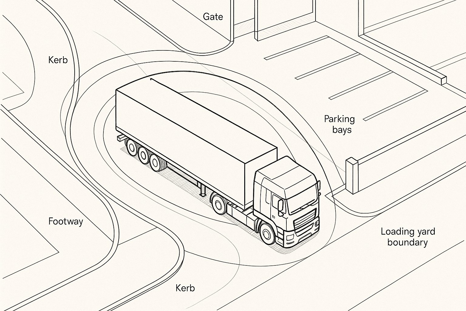
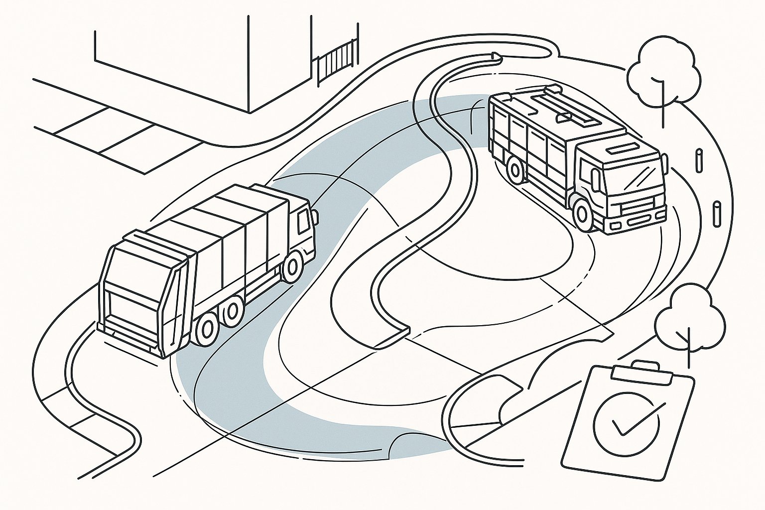
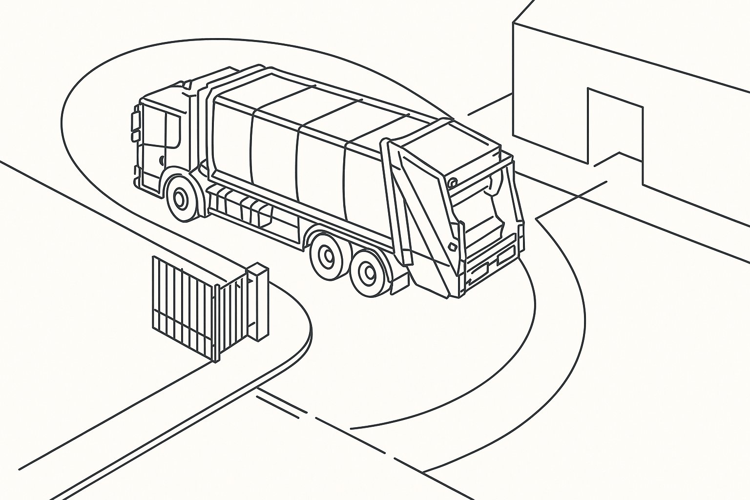
AutoTURN swept path analysis is a method of testing how much space a vehicle needs when it turns, circulates, enters a site, reverses into a bay, or exits onto the public highway. Using specialist software, we simulate the movement of a chosen vehicle over a scaled drawing so we can see its wheel tracks, body envelope and overhang in relation to kerbs, walls, parking bays, footways, gates and other constraints.
That sounds straightforward, but the value is significant. A site can appear compliant in plan form while still being unworkable for real vehicles. The front wheels may clear a bend while the rear wheels mount the kerb. A refuse vehicle may reach a turning head but need a shunt to get out. An articulated lorry may enter a loading yard only by cutting across opposing lanes or pedestrian space.
Swept path analysis turns those risks into measurable evidence. It shows whether geometry works before construction, before occupation and, ideally, before a planning officer or highway engineer raises an objection.
It matters because poor manoeuvrability creates practical and legal problems. Unsafe reversing, damage to street furniture, blocked footways, inaccessible servicing areas and emergency access failures all have planning implications. They also create operational headaches long after permission is granted.
In our experience, the best swept path work does two things at once: it protects design quality and it reduces approval risk. It gives the project team confidence that the layout is not just visually neat, but genuinely usable by the vehicles that will depend on it.
How Swept Path Analysis Supports Planning And Highway Approval
Planning and highway decisions increasingly rely on drawings that demonstrate operational realism. That is where swept path analysis carries real weight. Instead of asking officers to accept a narrative statement such as “service vehicles can access the site safely”, we provide a technical drawing showing exactly how that manoeuvre works.
For planning applications, this can be crucial where access arrangements, internal circulation, refuse collection, delivery strategy or emergency access form part of the assessment. If a proposal depends on a fire appliance reaching a specific point, or if bins are meant to be collected from inside the site boundary, the authority will often want to see the tracking.
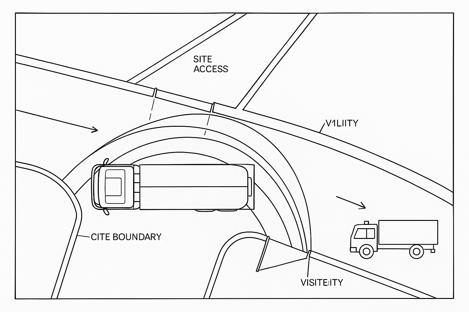
For highway approval, the same principle applies. Local highway authorities commonly review whether vehicles can enter and leave in forward gear, whether turning movements interfere with opposing traffic, and whether a design places pressure on footways, verges or visibility splays. A swept path drawing gives them visual and dimensional evidence.
It also helps align different technical disciplines. Architects, transport consultants, civil engineers and planning teams can all work from the same tested geometry. That often avoids the familiar problem of one drawing saying the access works while another quietly assumes a different kerb line.
From a practical standpoint, good vehicle tracking can shorten the approval process. It doesn’t remove every planning issue, of course, but it can answer one of the most common and most avoidable questions: can the site actually function for the vehicles it needs to accommodate?
When A Swept Path Assessment Is Typically Required
Not every development needs a formal swept path exercise, but many do. The usual trigger is simple: if the safe operation of a site depends on larger vehicles, constrained geometry or non-standard manoeuvres, a tracking assessment is likely to be needed.
This often arises on compact urban plots, backland developments, new estate roads, commercial yards, schools, care schemes, mixed-use projects and sites with underground parking or narrow access points. Junctions with tight radii, loading areas, internal bends, gated accesses and turning heads are all common pressure points.
Authorities are also more likely to request swept path evidence where reversing is proposed, where a vehicle must enter from a busy road, or where the consequences of getting the geometry wrong are obvious, think refuse collection, emergency response, servicing strategy or coach access.
Sometimes the requirement is explicit in pre-application advice or local guidance. Sometimes it emerges later through consultee comments. Either way, waiting too long can be expensive. If the assessment is left until after the layout has been fixed, small geometric problems can become major redesign issues.
Below are two of the most common planning contexts in which a swept path assessment becomes essential.
Planning Applications And Reserved Matters
At planning stage, swept path drawings are often used to prove that the broad development concept is deliverable. On outline or full applications, they may support access strategy, internal road layouts, parking courts, servicing arrangements or refuse collection points. The aim is not always to finalise every dimension, but to demonstrate that the proposal is viable in highway terms.
At reserved matters or detailed design stage, the drawings usually become more precise. Kerb lines, parking bay dimensions, building offsets, gate positions and landscape features are better defined, so the tracking can be refined accordingly. This is often when conditions attached to a planning permission need to be discharged.
We regularly find that reserved matters submissions benefit from revisiting earlier assumptions. A layout that worked at concept stage may tighten once levels, walls, planting, bin stores or cycle parking are added. The manoeuvre still needs to work in the real scheme, not the cleaner earlier version.
This is where a lot of applications either gain momentum or stall. If the vehicle tracking clearly matches the submitted layout, officers can assess it with confidence. If the drawings are inconsistent, underspecified or based on outdated geometry, that tends to invite requests for revision.
In short, swept path analysis is often part of proving not just that a scheme is acceptable in principle, but that it remains workable as the design develops.
Access Design, Servicing, And Refuse Collection
Access and servicing are among the most frequent reasons for carrying out an AutoTURN assessment. A development may look perfectly reasonable until we test the route of a refuse vehicle, rigid delivery lorry or fire appliance. Then the awkward bits appear: a gate set too close to the carriageway, an internal bend that narrows near visitor parking, or a turning head that works only if two spaces are kept empty.
Refuse collection is a classic example. Many local authorities have clear operational expectations around collection distances, reversing, turning and forward exit. If a refuse vehicle is expected to enter private land, the layout usually needs to demonstrate that this can happen safely and without unrealistic manoeuvres.
Servicing strategy raises similar issues. Retail units, apartment schemes, schools and employment sites all need practical arrangements for deliveries and collections. Loading bays have to be reachable. Vehicles need sufficient clearance to align, turn and leave. And if a vehicle overhangs a footway or blocks circulation while manoeuvring, the design may need to change.
Fire access can be even more sensitive. Building control, fire strategy and highway design don’t always speak the same language, so swept path analysis can help bridge that gap by showing whether the required appliance can physically reach the intended location.
In short, access design is where theory meets operation. The drawing either proves the route works, or it reveals that it doesn’t.
The Vehicles Commonly Tested In AutoTURN
One of AutoTURN’s practical strengths is its library of design vehicles. Rather than relying on a generic “large vehicle”, we can select a vehicle type that reflects the actual use of the site or the authority’s expected standard. That makes the resulting assessment much more defensible.
Commonly tested vehicles include:
- Passenger cars, often for basement parking, tight ramps and internal circulation checks
- Light goods vehicles (LGVs) for smaller servicing arrangements
- Rigid HGVs for deliveries, commercial access and some industrial sites
- Articulated lorries where larger freight movements are expected
- Buses and coaches for public transport access, schools, visitor facilities and highway schemes
- Refuse collection vehicles for residential and mixed-use development
- Fire appliances for emergency access testing
The right vehicle choice matters more than many teams first assume. Testing a site with a smaller vehicle than the one likely to use it can produce a reassuring but misleading result. Equally, selecting an overly onerous vehicle without justification can create unnecessary design pressure.
Good practice is to tie the chosen vehicle to the proposed operation, relevant standards and, where available, local authority expectations. If the council’s waste team expects a particular refuse vehicle format, that should inform the assessment. If a warehouse will genuinely receive articulated deliveries, we need to test that, not a rigid stand-in.
The goal is realism. A swept path drawing is only as persuasive as the vehicle assumptions behind it.
How An AutoTURN Assessment Is Carried Out
At its core, an AutoTURN assessment begins with a reliable base drawing and a clear question: which vehicle needs to go where, and under what conditions? We import or work from the proposed layout, select the appropriate vehicle from the software library, and then test the manoeuvre in forward and, where necessary, reverse movement.
The path can be generated interactively, allowing us to steer through the design in a realistic way, or refined iteratively until the vehicle movement reflects a credible operation. The output typically shows tyre tracks, body sweep and vehicle positions at key points in the manoeuvre.
But pressing “run” is the easy part. The technical judgement sits around it. We need to understand the planning context, the site constraints, the authority’s likely concerns and the difference between a manoeuvre that is merely possible and one that is genuinely acceptable in operation.
For example, a rigid lorry may be able to enter a service yard if driven with precision and with no conflicting traffic present. That does not necessarily mean the arrangement is suitable for approval. We still need to consider tolerance, clearance, visibility, pedestrian interaction and whether the movement feels realistic rather than theoretical.
Two parts of the process are especially important: the quality of the underlying assumptions, and the way the final manoeuvre is reviewed. Those are where good assessments are either built properly, or quietly undermined.
Base Drawings, Tracking Parameters, And Design Assumptions
A swept path assessment is only as sound as the drawing it sits on. If the base plan is inaccurate, outdated or missing critical constraints, the tracking result can be technically neat and completely unhelpful. That’s why we start by checking the geometry carefully: carriageway widths, kerb lines, radii, parking layouts, gates, visibility features, walls, islands, loading bays and any fixed street furniture that could affect movement.
We then select the right vehicle template and set parameters that reflect real-world operation. Depending on the scenario, that may include steering behaviour, turning radii, direction of travel and assumptions about how the vehicle approaches the manoeuvre. On some sites, even a small shift in starting position can alter whether the turn works.
Design assumptions should be transparent. If a manoeuvre relies on a vehicle crossing the centre line, using part of an opposing lane, or encroaching into an area that may be occupied, that needs to be visible and justified. Hidden assumptions are one of the main reasons authorities challenge submitted tracking.
We also need consistency with the wider planning package. If the landscape drawing adds trees within the swept envelope, or the architect’s revised plan narrows a bend that the tracking depends on, the analysis needs updating. This happens more often than teams like to admit.
In practice, careful setup saves time. It is far better to resolve assumptions at the start than to explain later why a “passing” drawing no longer matches the scheme being determined.
Reviewing Manoeuvres, Overhang, And Conflict Points
Once the tracking has been generated, the real assessment begins. We look beyond whether the wheels physically make the turn. The key questions are about clearance, overhang, tolerance and conflict.
Vehicle body overhang is often where problems emerge. The wheels may stay within the carriageway while the front or rear of the vehicle swings across a footway, clipped verge, parking space, boundary wall or gate pier. On constrained sites, that swing can be the deciding factor between a workable design and one that needs amendment.
We also review how the manoeuvre relates to surrounding activity. Does the vehicle cut across opposing traffic lanes? Does it obstruct pedestrian desire lines or cycle routes? Is it dependent on an adjacent parking bay being empty? Does reversing create a long blind movement that an authority is unlikely to support?
Conflict points matter because highway officers do not assess drawings in isolation. They think operationally. A manoeuvre that technically fits but creates regular conflict with pedestrians, deliveries, parked cars or oncoming traffic may still be unacceptable.
That is why we usually review movements at key stages rather than only as one continuous trace. Entry position, steering lock, apex, overhang at the tightest point, alignment into a bay and forward exit are all worth checking separately.
Good swept path analysis is not just about proving success. It is about exposing pinch points honestly enough that the design can be improved before those pinch points become planning objections.
Common Design Issues Revealed By Swept Path Analysis
Swept path analysis has a habit of revealing problems that are easy to miss in a static layout. Some are minor and can be fixed with a small kerb adjustment. Others point to a deeper issue in the site design.
Among the most common are:
- Insufficient junction radii, especially on tight urban accesses
- Vehicle overrun of footways or verges, creating pedestrian safety concerns
- Turning heads that are nominally present but operationally ineffective
- Parking spaces that obstruct servicing manoeuvres
- Loading bays that cannot be entered or exited cleanly
- Long or awkward reversing movements
- Conflicts between opposing vehicles in narrow internal roads
- Gate locations or boundary features that constrain the turning arc
One issue often leads to another. A designer may widen an access to help a refuse vehicle turn, only to discover that the revised geometry pushes overhang into a proposed planting strip or visibility splay. Or a servicing court may function in isolation but fail once parked cars and pedestrian routes are considered.
This is why we treat vehicle tracking as a design tool, not just a submission drawing. It can guide iteration early, when changes are still manageable. By the time a planning officer comments that a fire appliance cannot turn within the site, the scheme may already be under timetable pressure.
The uncomfortable truth is that many swept path problems are not software problems. They are layout problems. The analysis simply makes them impossible to ignore.
What Makes A Swept Path Drawing Acceptable To Local Authorities
Local authorities vary in style, but their expectations are usually more consistent than people think. An acceptable swept path drawing should be clear, proportionate, technically credible and obviously linked to the submitted layout.
In practical terms, authorities typically want to see:
- A readable scale and north point
- A clearly identified vehicle type, ideally with a recognisable standard reference
- Distinction between forward and reverse paths where both are shown
- Visible wheel tracks and body envelope/overhang
- Key clearance dimensions where manoeuvres are tight or contested
- A base drawing that matches the current proposed arrangement
- No hidden geometry, unexplained assumptions or selective omission of constraints
Presentation matters more than many applicants realise. If a drawing is cluttered, cropped too tightly or based on faint background geometry, officers may struggle to verify what is being shown. That often leads to a request for clarification even where the movement itself is satisfactory.
Context also matters. A good submission usually includes a concise explanation of what is being tested, why that vehicle has been chosen and what the result demonstrates. Not a long essay, just enough to make the drawing easy to assess.
From our perspective, the best way to secure confidence is simple: give the authority a drawing that answers their likely questions before they have to ask them. In planning, that is half the battle.
Conclusion
In 2026, AutoTURN swept path analysis remains one of the clearest ways to demonstrate that a development can operate safely and practically, not just look acceptable on a layout plan. For planning applications, reserved matters, access design and highway approval, it provides evidence that the right vehicles can enter, manoeuvre, service and leave without creating avoidable safety or operational problems.
For architects, planners, developers and councils, that evidence is valuable because it reduces uncertainty. It helps identify design weaknesses early, supports coordination between disciplines and gives decision-makers something more reliable than assumption.
We’ve found that the strongest outcomes usually come from carrying out swept path analysis early enough to influence design, not late enough merely to defend it. When the base drawings are accurate, the vehicle assumptions are realistic and the presentation is clear, the assessment becomes much more than a technical appendix. It becomes part of how a scheme earns confidence.
And on constrained sites, that confidence can make all the difference.
Frequently Asked Questions about AutoTURN Swept Path Analysis
What is AutoTURN swept path analysis and why is it important in planning?
AutoTURN swept path analysis simulates vehicle movements to show the space required for turning, reversing, and servicing a site. It ensures that layouts are operationally safe and feasible, reducing costly redesigns and helping planning authorities approve schemes confidently.
When is a swept path assessment typically required for a development project?
Swept path assessments are usually needed when large vehicles must manoeuvre in constrained spaces, such as urban plots, new estate roads, loading bays, or where reversing is proposed. They help prove that vehicles like refuse trucks, fire appliances, or delivery lorries can access and exit safely.
How does AutoTURN support highway approvals and planning applications?
AutoTURN provides technical drawings showing exact vehicle paths, validating that service, emergency, and delivery vehicles can navigate the site safely, often in forward gear. This visual evidence assists highway officers and planners in assessing operational realism rather than relying on narrative assurances.
Which types of vehicles are commonly tested using AutoTURN swept path analysis?
AutoTURN’s extensive vehicle library includes passenger cars, light goods vehicles, rigid and articulated lorries, buses, coaches, refuse collection vehicles, and fire appliances. Selecting the correct vehicle type relevant to the site operation ensures realistic and defensible assessments.
What makes a swept path drawing acceptable to local authorities?
Authorities expect clear drawings with a readable scale, north point, clearly identified vehicle types, distinguishable forward and reverse paths, visible wheel tracks and overhang, critical clearance dimensions, and consistency with the proposed site layout. Transparency and clarity are key to approval.
How can swept path analysis help identify and resolve design issues?
Swept path analysis reveals practical problems like insufficient junction radii, vehicle overhang blocking footways, ineffective turning heads, and conflicts with pedestrian or vehicle movements. Identifying these early allows designers to adjust layouts before costly planning objections or construction.