Planning applications in Hull rarely succeed on land use arguments alone. If a scheme changes how people, goods, and service vehicles move, transport planning quickly becomes central to whether an application progresses smoothly or stalls in validation, consultation, or determination.
That is especially true in a city like Kingston upon Hull. The local network has to support everyday commuting, school travel, port activity, city-centre access, logistics, and regeneration ambitions, all while cutting congestion and moving towards lower-carbon travel. Hull City Council’s Local Transport Plan 2020–2026 sets a clear direction: growth is expected to work with the network, not simply add pressure to it.
For architects, planners, surveyors, developers, legal teams, and local authorities, that means transport evidence needs to be proportionate, policy-led, and grounded in the realities of the site. A strong submission doesn’t just answer whether vehicles can get in and out. It shows how the development fits into walking routes, cycle links, bus accessibility, parking demand, servicing, highway safety, and wider network performance.
In this guide, we set out the practical side of transport planning in Kingston upon Hull: when evidence is likely to be needed, which documents usually matter, how Hull’s transport priorities affect development proposals, and where applications most often come unstuck. The aim is simple, help teams prepare better evidence earlier, reduce avoidable objections, and improve the chances of a smoother planning outcome in 2026.
Why Transport Planning Matters In Kingston Upon Hull
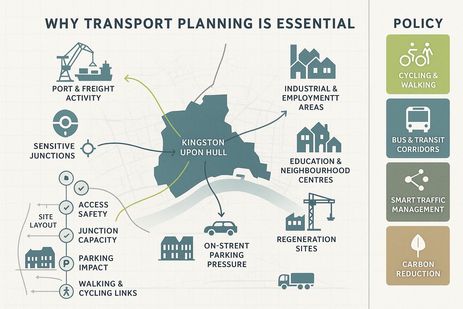
Transport planning matters in Hull because access is tied directly to economic function, placemaking, and policy compliance. This is a city shaped by its port, industrial activity, education uses, neighbourhood centres, and regeneration sites. A proposal that works in pure site-layout terms can still run into trouble if it creates unsafe access, overloads a junction, worsens parking stress, or ignores opportunities for walking, cycling, and bus travel.
Hull City Council’s Local Transport Plan 2020–2026 is important here. It is not just a background strategy document: it signals how the authority expects growth to interact with the transport network. Its priorities include a stronger cycling and walking city, better transit corridors, smarter network management, and movement towards carbon neutrality. In practical planning terms, that means applicants are expected to show more than basic vehicle access. We need to demonstrate that development can support efficient, safe, and sustainable movement patterns.
There is also a local realism to this. Some parts of Hull have established urban streets, constrained frontages, on-street parking pressure, and sensitive junctions. Others sit close to strategic freight routes or employment areas where servicing and HGV activity are a major issue. So transport planning in Kingston upon Hull is not a generic box-ticking exercise. It is a matter of understanding the street, the network, and the planning policy context early enough to design around them rather than react later.
When A Development In Hull Is Likely To Need Transport Evidence
Not every planning application in Hull needs a full technical transport package, but many do need some level of evidence. As a rule, the bigger the development, the more likely it is to require a formal Transport Assessment, Transport Statement, Travel Plan, or a combination of these. Size is only part of the picture, though. A relatively modest proposal can still trigger transport scrutiny if the site sits on a constrained road, near a sensitive junction, in an area of parking stress, or where servicing arrangements are awkward.
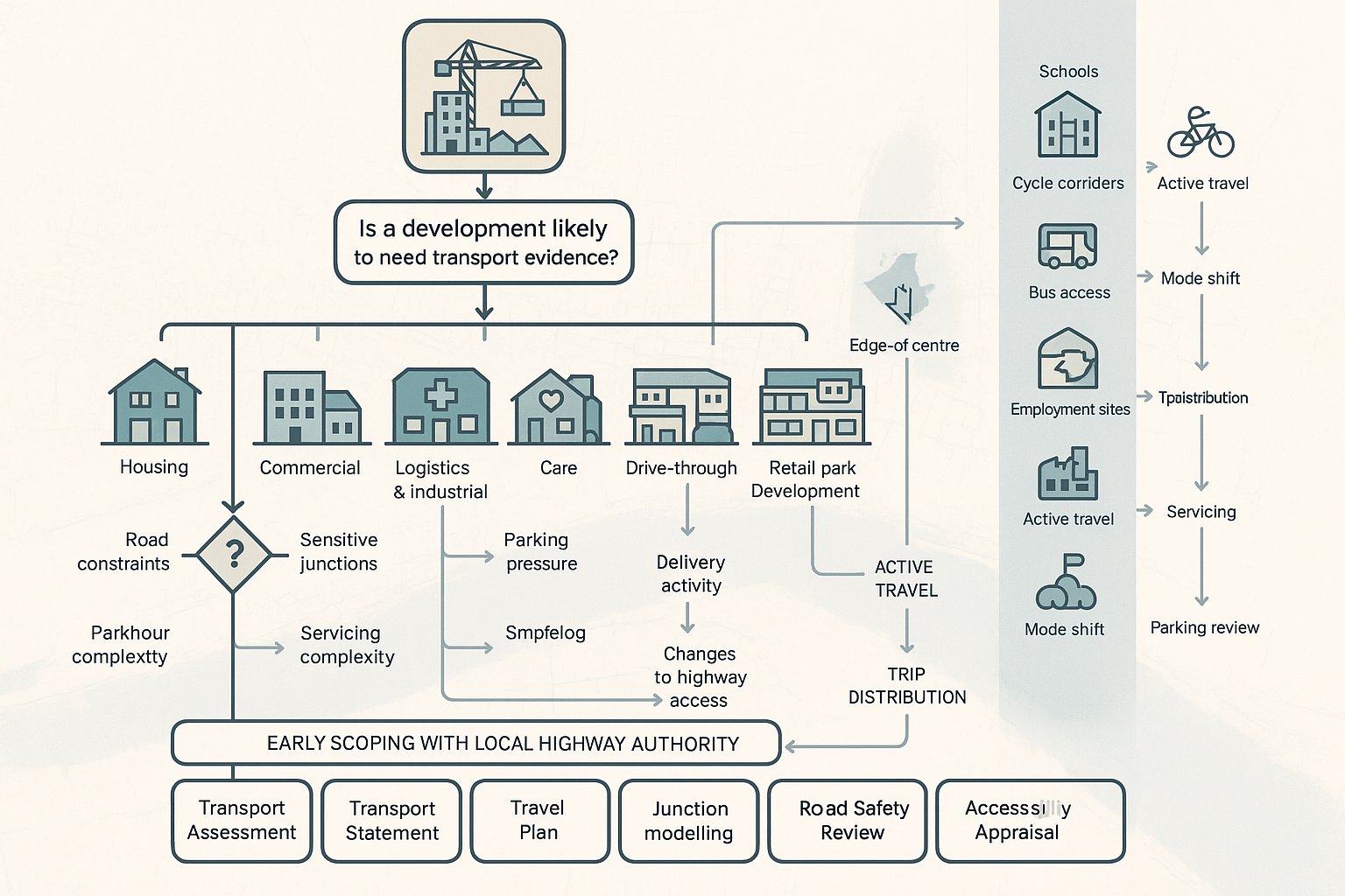
In practice, larger housing schemes, commercial development, logistics and industrial proposals, care uses, education sites, drive-throughs, retail parks, and town-centre schemes often require structured transport input. So do developments expected to generate noticeable peak-hour trips, attract deliveries, involve significant staff movements, or alter access arrangements onto the public highway.
We also look at context. A scheme close to schools, near established cycle corridors, or in an area with realistic bus access may face stronger expectations around active travel and mode shift. Conversely, edge-of-centre or employment sites may need more detailed justification on trip distribution, servicing, and parking.
The safest approach is to review likely requirements before submission rather than guessing from floor area alone. Early scoping with the local highway authority can save weeks. It clarifies whether the authority expects a TA, TS, Travel Plan, junction modelling, swept-path work, road safety commentary, or an accessibility appraisal, and that clarity often makes the difference between a clean validation and a messy one.
The Main Transport Planning Documents Used In Planning Applications
Most transport submissions in Hull are built around a small group of core documents, supported by drawings and technical appendices where needed. The exact package depends on the scale and complexity of the proposal, but the starting point is usually the local and national policy framework.
At local level, the Hull Local Transport Plan 2020–2026 is a key reference point because it sets out how the city intends to manage and improve movement. Alongside that, applicants need to consider Local Plan transport and parking policies, plus any relevant development management guidance, sustainable travel expectations, and highway design standards. National planning and transport practice then shapes methodology, proportionality, and impact assessment.
From there, the technical reports usually do the heavy lifting. Depending on the scheme, these may include a Transport Assessment or Transport Statement, a Travel Plan, an access appraisal, junction-capacity work, collision analysis, swept-path drawings, parking studies, and framework servicing information. For some developments, especially where access or parking is contentious, the drawings can be just as important as the written report.
Good documentation is not about volume. We have seen concise reports succeed because they answer the right questions clearly, with credible assumptions and a realistic mitigation strategy. Equally, lengthy reports can still fail if they dodge core issues such as poor pedestrian links, unclear servicing, or an over-optimistic parking case.
Transport Assessment Vs Transport Statement Vs Travel Plan
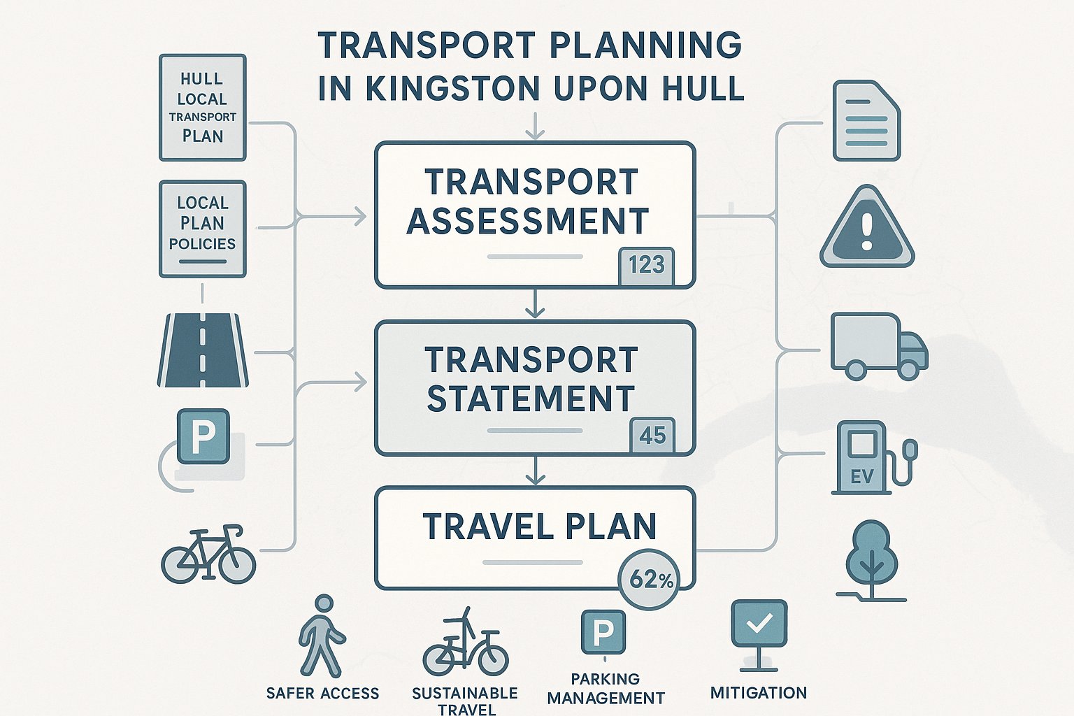
A Transport Assessment is the most detailed of the three. It is typically used for larger or more traffic-intensive development and provides a structured, evidence-based review of how the scheme will affect the transport network across all relevant modes. That often includes trip generation, trip distribution, junction-capacity analysis, road safety considerations, servicing, parking, accessibility, and mitigation.
A Transport Statement is lighter touch. It is still a technical document, but proportionate to smaller schemes with more limited transport effects. A TS may focus on existing conditions, likely trip impact, access suitability, parking, and sustainable travel opportunities without extensive modelling.
A Travel Plan is different again. Rather than simply assessing impact, it sets out how travel behaviour will be influenced over time. That may include measures such as cycle parking, bus information, car sharing, personalised travel information, EV provision, or staff incentives. In Hull, where policy emphasis falls heavily on active travel, public transport, and lower-emission movement, weak Travel Plans can look tokenistic very quickly. The best ones are practical, monitored, and tailored to the actual users of the site.
How Hull’s Local Transport Network Shapes Development Planning
Hull’s transport network has a distinct planning character. It combines dense urban neighbourhoods, key radial corridors, city-centre movements, industrial areas, and strategic freight connections linked to the port and wider regional economy. That means development planning here is shaped not only by local street design but by how a site interacts with bigger movement patterns.
The Local Transport Plan 2020–2026 sets out three particularly relevant themes: strengthening walking and cycling, improving city transit corridors, and supporting a smart green city. Those priorities feed directly into planning expectations. If a proposal sits near a route with active-travel potential, we should expect scrutiny of footway quality, crossing opportunities, cycle access, and permeability. If it fronts a key corridor, public transport interaction and junction performance may become more important. If it is car-led in a location with realistic alternatives, it may face tougher questions.
Hull’s network also creates location-specific constraints. In established urban areas, narrow frontages, closely spaced junctions, frontage parking, and regular bus movements can limit access options. In employment or port-related areas, HGV routing and peak operational traffic can dominate the analysis. Around centres and mixed-use areas, the issue is often not whether access exists, but whether it works safely and efficiently without harming existing network operation.
This is why transport planning in Kingston upon Hull needs a local reading of the network. We cannot assess sites in abstract terms. The same development quantum can be acceptable in one part of the city and problematic in another simply because route choice, street hierarchy, public transport offer, and active-travel conditions differ.
Key Site Access, Highway Safety, And Parking Considerations
Three issues appear in almost every transport review in Hull: access, safety, and parking. They sound straightforward, but they are usually where the difficult planning conversations happen.
First, site access. The authority will want confidence that vehicles can enter and leave safely, that the proposal does not create conflict with pedestrians or cyclists, and that the access arrangement is suitable for the street type. Existing vehicle crossings are not automatically acceptable for intensified use. A quiet former access can become problematic if a new scheme increases turning movements, introduces delivery vehicles, or changes the timing of activity.
Second, highway safety. This is not limited to recorded collision data, though collision history matters. We also need to consider geometry, visibility, traffic speeds, crossing desire lines, cycle movements, likely driver behaviour, and whether the proposal introduces unusual conflict points. In many urban locations, safety concerns arise less from headline traffic volume and more from awkward manoeuvres, poor driver inter-visibility, or vehicles overrunning footways.
Third, parking. Hull applications often attract strong comments on parking even where wider transport impacts are modest. Under-provision can trigger overspill concerns: over-provision can undermine sustainable travel objectives and weaken the policy case. The right answer is rarely “as much as possible”. We need a balanced, evidence-led response based on local standards, likely user profile, accessibility, and actual demand patterns.
What helps most is alignment between the report and the drawings. If the text says servicing is acceptable but the layout leaves vans reversing awkwardly across pedestrian routes, the weakness will be obvious.
Junction Capacity, Visibility, Servicing, And Internal Layout
Where an application generates noticeable traffic, junction capacity quickly moves up the agenda. That may involve simple priority-junction review, committed development context, or formal modelling where impacts could be material. The key is proportionality. We do not need elaborate modelling for every site, but we do need enough evidence to show whether queues, delay, or reserve capacity become an issue.
Visibility is another recurring point. Appropriate visibility splays depend on speed environment, street form, parked vehicles, boundary treatment, and vulnerable road users. In built-up parts of Hull, achieving textbook visibility can be difficult, so the argument often turns on actual operating conditions rather than idealised geometry alone.
Servicing deserves more attention than it sometimes gets. Bin collection, parcel deliveries, trade vehicles, and larger service movements can make or break a scheme. If a site relies on on-street loading in a sensitive location, or if large vehicles need to reverse excessively, objections are far more likely. Swept-path analysis and a realistic servicing plan usually repay the effort.
Then there is internal layout. It needs to function for cars, cycles, pedestrians, refuse vehicles, and emergency access without feeling improvised. Tight corners, blocked footway links, hidden cycle parking, or unusable turning heads are all classic warning signs. Good transport planning catches these issues before the application drawings are locked in.
Sustainable Travel Expectations For New Development In Hull
Hull’s policy direction is clear: development should support lower-carbon movement and make walking, cycling, and public transport realistic choices, not afterthoughts. That does not mean every site can achieve the same level of modal shift, but it does mean applicants are expected to engage properly with sustainable travel rather than mention it briefly and move on.
For many schemes, this starts with location efficiency. Is the site near jobs, schools, shops, health services, and bus routes? Are there practical walking connections? Can cyclists access the site directly and safely? Are secure cycle facilities designed in from the outset? If the answer to those questions is broadly yes, the transport submission should reflect that in parking strategy, trip assumptions, and any Travel Plan commitments.
Hull’s Local Transport Plan promotes active travel as the first choice for short trips and supports improved public transport corridors and low-emission infrastructure. In planning terms, that can translate into expectations around cycle parking quality, pedestrian permeability, EV charging provision, bus stop accessibility, and user information. A scheme that defaults to maximum car access while doing the bare minimum elsewhere can look out of step with local policy.
That said, sustainable travel arguments need to be credible. We should not overstate bus attractiveness where service frequency is weak, or pretend an inconvenient walking route is acceptable just because it exists on a map. The strongest submissions are honest about current conditions, then set out practical measures that genuinely improve travel choice.
Walking, Cycling, Public Transport, And Accessibility Appraisal
Accessibility appraisal is where a lot of transport statements quietly win or lose credibility. It is not enough to note that a bus stop sits within a certain distance, or that a footway exists on one side of the road. We need to consider actual usability.
For walking, that means route directness, crossing points, lighting, footway width, frontage activity, and whether key local destinations can be reached comfortably. For cycling, it means route continuity, crossing quality, traffic stress, cycle parking design, and links to existing or planned corridors. For public transport, it means stop quality, frequency, destination coverage, service reliability in broad terms, and whether the likely users of the development would see it as a genuine option.
A sound accessibility appraisal in Hull should reflect the city’s emphasis on integrated travel. If a development is in a relatively sustainable location, we should say so and explain why. If it is not, we should be equally clear and identify mitigation that is realistic, whether that is improved pedestrian access, travel information, bus stop upgrades, or better cycle facilities. Vague claims about “encouraging sustainable travel” do not carry much weight anymore.
Typical Development Types And Their Transport Planning Challenges
Different development types create different transport risks, and one of the easiest mistakes in planning is to recycle a standard transport approach across all of them.
Residential development in Hull often raises questions around parking accumulation, school-run traffic, refuse access, and walkability to local facilities. Even smaller schemes can become contentious where surrounding streets already experience heavy on-street parking or where access sits close to junctions. Family housing and flatted schemes may also behave differently in parking and servicing terms, so assumptions need to match the product.
Employment, industrial, and logistics development bring another set of issues. HGV routing, shift change traffic, staff car demand, servicing yards, and junction performance tend to dominate. On port-related or freight-sensitive sites, the timing and composition of traffic can matter as much as total volume. A development that looks acceptable on daily flows may still create operational problems at gate peaks or on specific freight corridors.
Retail and leisure uses often generate sharper peak effects, with parking turnover, weekend demand, linked trips, and short-stay behaviour all relevant. Town-centre and edge-of-centre sites may also need careful treatment of servicing windows and pedestrian conflict.
Education, healthcare, and community uses can be especially sensitive because activity is concentrated around distinct periods and user groups. A school expansion, for instance, may create more concern about drop-off behaviour than about formal junction capacity.
The lesson is simple enough: the transport evidence should reflect the actual use class, likely user profile, and operational pattern of the scheme, not just its floor area.
The Transport Planning Process From Initial Review To Decision
A smoother application usually starts long before the planning submission. In our experience, the transport planning process works best when it follows a clear sequence and feeds into the design team early.
First comes the initial review. We look at planning policy, highway context, site constraints, likely trip characteristics, nearby junctions, sustainable travel opportunities, and whether there are obvious red flags such as substandard access width or servicing conflict. This stage often tells us whether a full TA is likely or whether a TS may be enough.
Next is scoping. Where appropriate, we engage with the local highway authority to agree the broad scope of work. That can cover assessment years, committed development, survey requirements, accident data, modelling approach, Travel Plan expectations, and drawing needs. A short scoping discussion can prevent a lot of rework later.
Then comes data collection and analysis. Depending on the site, that may include traffic counts, parking surveys, speed data, accessibility review, collision analysis, trip generation benchmarking, and junction modelling. We then prepare the TA, TS, or Travel Plan, making sure the narrative matches the design proposals.
After submission, the process often moves into negotiation. Comments may focus on parking, off-site works, access geometry, Travel Plan measures, or planning conditions. Some schemes need amendments or further justification. Others move cleanly because the evidence was proportionate and site-specific from the start.
If permission is granted, that is not always the end. Travel Plans, in particular, may involve monitoring, coordinator roles, or phased review. That follow-through matters because authorities increasingly expect sustainable travel commitments to be real, not decorative.
Common Reasons Transport Submissions Run Into Problems
Most weak transport submissions do not fail because the site is impossible. They fail because the evidence is thin, poorly targeted, or disconnected from the scheme design.
A common issue is underestimating trip generation. That can happen through selective benchmarking, unrealistic mode share assumptions, or failure to account for how the development will actually operate. In Hull, where local context varies sharply, generic national comparisons without local judgement can look flimsy.
Another regular problem is ignoring cumulative impact. Committed developments, background growth, and nearby changes to the network matter, especially around busy corridors and urban junctions. If a report treats the site in isolation when everyone knows the area is changing, trust drops quickly.
Junction and safety analysis are also frequent weak spots. We sometimes see reports rely on broad assurances where a targeted capacity review or collision analysis is clearly needed. Equally, access drawings may be submitted with unresolved visibility, servicing, or swept-path issues that should have been fixed before validation.
Travel Plans can be another stumbling point. A generic document full of standard measures but no delivery framework, targets, or monitoring arrangements tends not to carry much weight. Authorities want to know who will do what, by when, and how success will be measured.
And finally, poor treatment of walking, cycling, and public transport remains a classic mistake. In a policy environment shaped by active travel and decarbonisation, these modes cannot be covered in two paragraphs. They need proper analysis.
For project teams that want quick, accurate reporting, that is often where experienced local transport input earns its keep. Firms such as ML Traffic focus on concise, planning-ready evidence tailored to authority expectations, which is often exactly what keeps an otherwise good application from drifting into avoidable transport objections.
Conclusion
Transport planning in Kingston upon Hull is eventually about fit: fit with the street, the network, the policy framework, and the real travel behaviour a development will generate. Hull’s Local Transport Plan 2020–2026 sets a clear direction of travel, and successful planning applications are the ones that respond to it directly, not defensively.
For applicants, that means starting early, scoping properly, and producing evidence that is proportionate but robust. Safe access, realistic parking, workable servicing, junction performance, and strong treatment of walking, cycling, public transport, and low-carbon travel all matter. So does honesty. A clear, well-reasoned report that acknowledges constraints and sets out sensible mitigation will usually travel further than a glossy document that avoids the hard points.
Done well, transport planning is not a hurdle added at the end. It is part of how better development gets designed, justified, and approved in Hull.
Transport Planning FAQs for Kingston upon Hull
Why is transport planning particularly important for developments in Kingston upon Hull?
Transport planning is crucial in Kingston upon Hull because the city’s network supports diverse needs including commuting, port operations, and regeneration, while aiming to reduce congestion and promote low-carbon travel as outlined in the Local Transport Plan 2020–2026.
When does a development proposal in Hull require a Transport Assessment, Statement, or Travel Plan?
Major, traffic-intensive developments like large housing, commercial, retail, and logistics schemes usually need formal Transport Assessments or Statements and Travel Plans. Even smaller schemes near constrained roads or sensitive junctions may require transport evidence to address local network impacts.
What are the key differences between a Transport Assessment, a Transport Statement, and a Travel Plan?
A Transport Assessment provides a detailed appraisal of all transport impacts for larger schemes. A Transport Statement is a lighter, proportionate review for smaller developments. A Travel Plan focuses on ongoing strategies to encourage sustainable travel modes, such as cycling and public transport, over time.
How does Hull’s Local Transport Plan 2020–2026 influence transport planning for development?
The Local Transport Plan 2020–2026 guides developments to align with goals such as enhancing walking and cycling routes, improving public transit corridors, smart green infrastructure, and carbon neutrality, requiring transport proposals to support safe, sustainable, and integrated travel choices.
What access, safety, and parking considerations are essential in Hull transport submissions?
Transport evidence in Hull must demonstrate safe and suitable site access, appropriate junction capacity and visibility, effective servicing arrangements, and balanced parking provision consistent with local standards, ensuring no adverse effects on highway safety or network performance.
How can developers ensure their transport submissions avoid common pitfalls in Kingston upon Hull?
Developers should prepare robust, site-specific transport evidence early, accurately estimate trip generation including cumulative impacts, conduct necessary junction and safety analyses, develop realistic and monitored Travel Plans, and thoroughly assess walking, cycling, and public transport connectivity.