Planning applications rarely fail because a drawing looked untidy. They fail because a key technical issue was left too late, under-scoped, or explained badly. In practice, transport is one of the most common pressure points. Access, traffic impact, parking, servicing, active travel links, junction capacity, these are the details that can turn a promising scheme into a negotiation, a delay, or a refusal.
That is exactly why Transport Planning in Petersborough deserves early, practical attention. For architects, planners, lawyers, surveyors, developers, builders and local authorities, the challenge is not just producing a report. It is producing the right evidence, at the right scale, in a way that fits local policy and highway authority expectations.
In Peterborough, transport planning sits within a wider policy landscape shaped by the Cambridgeshire & Peterborough Combined Authority, the Local Transport and Connectivity Plan, and the City Council’s development management process. So the question is not simply, “Do we need a Transport Statement?” It is also, “How will this site function, how will people reach it, and can we show that clearly enough to support consent?”
In this guide, we set out what transport planning covers, when technical assessments are needed, what officers typically expect, and how to put together a stronger submission in 2026, without wasting time on generic paperwork that does not answer the real planning questions.
What Transport Planning Covers In Petersborough
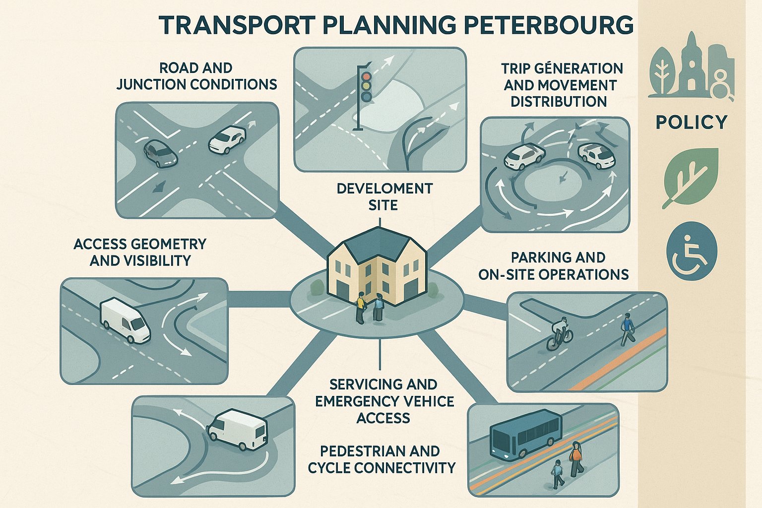
Transport planning for planning applications is broader than many teams first assume. It is not limited to counting cars or drawing a site access. In Peterborough, it typically covers how a development connects to the existing highway network, whether it can be accessed safely by all users, what effect it will have on traffic conditions, and how well it supports walking, cycling and public transport.
That means a proper transport review often looks at several linked questions at once:
- existing road conditions and nearby junction performance
- access geometry and visibility
- likely trip generation and distribution
- parking demand and operational needs
- servicing, refuse, delivery and emergency access
- pedestrian and cycle connectivity
- bus accessibility and wider sustainable travel opportunities
The local policy context matters here. Peterborough’s transport planning framework is tied to the strategic direction of the Cambridgeshire & Peterborough Combined Authority and the Local Transport and Connectivity Plan, with emphasis on a faster, greener and more accessible network. In plain terms, proposals are expected to do more than avoid severe highway harm: they should also respond to sustainable transport objectives where relevant.
For us, the most effective transport planning work in Petersborough starts with a simple principle: assess how the site will actually operate day to day. A strong submission is usually one that links technical evidence to real-world use, residents arriving home, delivery vans turning safely, cyclists crossing the frontage, and peak-hour traffic interacting with nearby junctions.
Why It Matters Early In The Planning Process
Early transport input saves redesign, reduces planning risk, and often improves development value. That sounds obvious, but it is still common for transport to be treated as a late-stage report-writing exercise. By then, the red line boundary is fixed, the building footprint is settled, parking is squeezed in, and access options are more limited than they needed to be.
When we look at schemes early, transport planning can shape fundamentals: where the access should sit, whether the quantum of development is realistic, how service vehicles will move, whether pedestrian routes feel natural, and how much parking is defensible. These are not minor details. They affect layout efficiency, viability, and the tone of conversations with officers.
Early work is especially useful where a site is constrained, close to busy junctions, on a classified road, near schools, within an urban centre, or in an area where active travel expectations are high. On those sites, a quick feasibility review can identify transport red flags before the design team invests too heavily in the wrong arrangement.
And there is a planning advantage too. If a proposal clearly aligns with local transport objectives from the start, it is easier to justify during validation, consultation and determination. In many cases, that means fewer follow-up questions, fewer surprises from the highway authority, and a much more proportionate evidence base. Put bluntly: transport problems are cheaper to solve on a sketch plan than after submission.
Local Planning Policy And Highway Authority Expectations
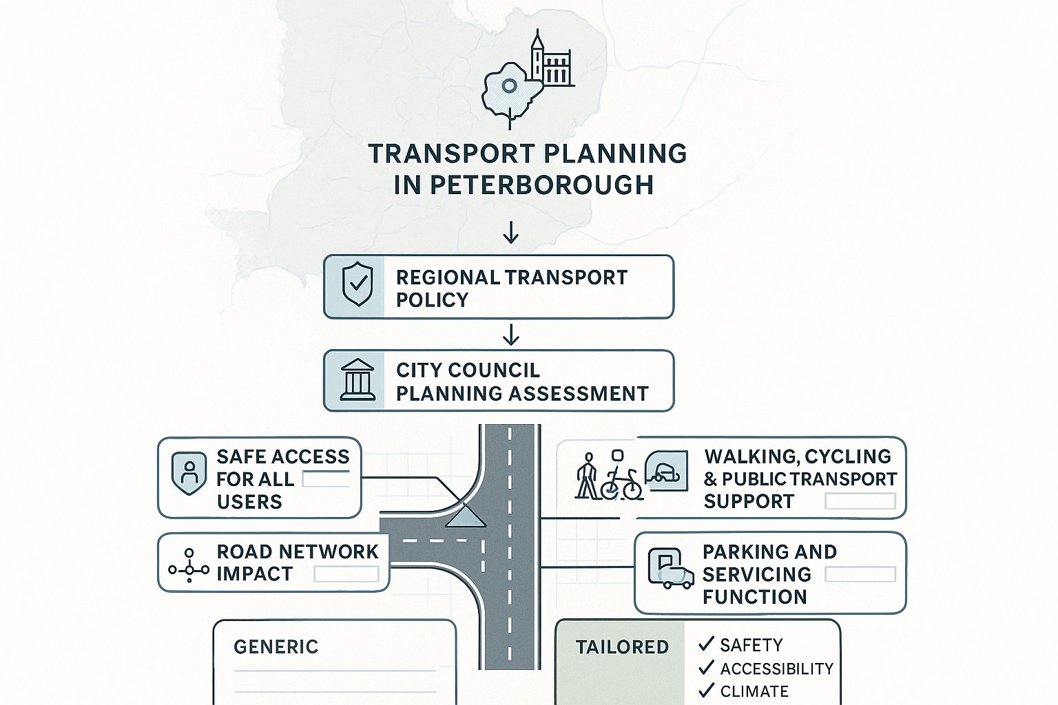
In Peterborough, transport planning decisions do not sit in a vacuum. The strategic direction comes from the Cambridgeshire & Peterborough Combined Authority (CPCA) as Local Transport Authority, particularly through the Local Transport and Connectivity Plan. Peterborough City Council then applies relevant transport and development management policies through the local planning process.
So what do officers and consultees usually expect? At a practical level, they want to see that a scheme:
- provides safe and suitable access for all users
- does not create unacceptable residual cumulative impacts on the road network
- supports walking, cycling and public transport where feasible
- includes parking and servicing arrangements that work operationally
- offers mitigation where impacts arise
The phrase “safe and suitable access” does a lot of work in planning decisions. It covers geometry, visibility, gradients, conflict points, and how different users interact at the site edge. But expectation goes further than minimum technical compliance. Authorities increasingly want evidence that the development has been planned with sustainable accessibility in mind, not simply private car access.
This is where local awareness counts. Thresholds, common concerns and preferred levels of detail can vary between authorities and by site context. A concise, accurate report tailored to Peterborough’s planning context will usually perform better than a long generic document. In our experience, submissions are strongest when they tie each technical conclusion back to local policy aims, network safety, accessibility, climate objectives and realistic day-to-day operation.
When A Transport Statement Or Transport Assessment Is Needed
Not every planning application needs the same level of transport evidence. The key test is whether the proposal is likely to have a material transport impact. If impacts are relatively limited, a Transport Statement (TS) may be enough. If the scheme is larger, more complex, or located on a sensitive part of the network, a Transport Assessment (TA) is more likely to be expected.
A Transport Statement is generally the more proportionate document for smaller or lower-impact schemes. It explains existing conditions, access arrangements, parking, likely trip effects and any modest mitigation. A Transport Assessment goes further. It usually includes more detailed trip generation analysis, traffic distribution, future-year forecasting, junction modelling, sustainable accessibility review and a fuller mitigation strategy.
Scale is only part of the picture. Location matters just as much. A modest development on a constrained route, close to a busy junction, or in an area with existing parking stress may justify more assessment than a larger scheme in a less sensitive setting.
As a rule, teams should consider a TS or TA where the authority will reasonably ask:
- how many trips the scheme will generate
- whether nearby junctions can accommodate them
- whether access is safe
- whether parking and servicing are workable
- whether sustainable travel opportunities have been properly addressed
The best approach is usually to agree scope early where possible. That avoids the familiar problem of preparing too little, then having to retrofit extra analysis under time pressure.
How Site Access And Highway Impact Are Evaluated
Site access is often the first transport issue everyone notices, and sometimes the one that determines whether the wider scheme progresses smoothly. But access appraisal is not just about whether a vehicle can physically enter and leave. It is about how the access performs in context: on that road, with those traffic conditions, for those users.
Authorities will usually consider the relationship between the proposed access and the surrounding network, including road hierarchy, existing traffic speeds, frontage activity, nearby junctions, pedestrian movements and collision history where relevant. An access that looks workable on a drawing can become much less convincing once local conditions are brought into the picture.
Equally, highway impact is judged through both safety and capacity. A site may have a technically compliant access yet still raise concern if development traffic adds pressure to already stressed junctions or creates awkward turning conflicts. The evaluation hence needs to be rounded, not siloed.
A robust submission will normally combine plans, visibility checks, traffic data, trip analysis, and operational review so the authority can understand not only what is proposed, but how it will function over time.
Junction Capacity, Trip Generation, And Traffic Forecasting
Trip generation usually starts with established database evidence, adjusted where necessary to reflect the development type, location and likely mode share. That sounds straightforward, but judgement matters. Poorly selected trip rates can undermine an otherwise competent assessment very quickly.
Once trips are identified, they are distributed and assigned across the surrounding network to test where impact falls. From there, junction assessments may be undertaken for priority junctions, roundabouts or signalised layouts, depending on context. The usual comparison is between a future-year baseline scenario and a future-year with-development scenario.
This modelling is not just a box-ticking exercise. Done properly, it helps answer practical planning questions: Will queues materially worsen? Is there reserve capacity? Would a right-turn lane, signal tweak or access redesign solve the issue? And if no mitigation is proposed, is that because impact is genuinely limited, or because the analysis has not gone deep enough?
Forecasting also needs to be credible. Authorities tend to be alert to optimistic assumptions, especially on constrained networks. Transparent inputs and proportionate sensitivity testing go a long way.
Visibility, Servicing, And Internal Layout Considerations
Visibility remains one of the most common technical flashpoints in transport planning. The authority will want confidence that drivers can see and be seen appropriately, taking account of road speed, alignment, boundary treatment and likely real-world conditions, not just a best-case desktop assumption.
Servicing is another area where otherwise sound schemes can unravel. Refuse vehicles, delivery vans and larger service vehicles need to enter, turn, stop and leave safely. If they cannot, the consequence is often overspill activity on the public highway, reversing concerns, or operational friction for neighbours.
That is why swept-path analysis is often important. It demonstrates whether the design accommodates the vehicles it claims to support, and whether tracking works without unrealistic overrun or conflict with parked cars and pedestrians.
Internal layout matters too. A well-designed scheme separates pedestrian desire lines from vehicle manoeuvring as far as reasonably possible, avoids dead corners, and allows intuitive movement. Good transport planning here is partly technical, partly common sense. If the layout looks awkward on paper, it usually feels worse when built.
Active Travel, Public Transport, And Sustainable Accessibility
This is one of the biggest shifts in planning over the past few years: transport submissions are increasingly expected to show not only that a development can be reached by car, but that it supports sustainable accessibility in a meaningful way. In Peterborough, that sits squarely within the wider ambitions of the Local Transport and Connectivity Plan, better integration, reduced car dependence where feasible, and healthier, lower-carbon travel patterns.
For applicants, that means reviewing the site through a wider lens. Are there usable walking routes to local facilities? Are cycle connections direct and safe, or technically present but unattractive? Is there a realistic bus option within a reasonable walk, and does service frequency make that option credible for likely users?
A good accessibility review usually goes beyond listing distances. It explains quality. A bus stop 400 metres away is less persuasive if the route to it crosses hostile junctions, has poor lighting, or lacks dropped kerbs. Likewise, a cycle route matters more when it links into somewhere people actually need to go.
In practical planning terms, sustainable accessibility can influence:
- the level and type of parking proposed
- whether off-site walking or cycling links are needed
- Travel Plan measures
- the overall acceptability of the development in policy terms
And yes, there is sometimes tension. Not every site will support a dramatic modal shift. But authorities will still expect applicants to demonstrate that opportunities for active travel and public transport have been properly tested, not brushed aside.
Parking Strategy, Servicing, And Operational Movement
Parking is one of those topics that everyone has a view on, and often a strong one. In planning, though, parking strategy needs to be evidence-led. Too little parking can displace vehicles onto surrounding streets and trigger objections from residents or highway officers. Too much can conflict with sustainable transport aims, weaken placemaking, and consume valuable developable area.
That balance is especially important in Peterborough, where site context can vary sharply between central, edge-of-centre and suburban locations. A sensible parking strategy should respond to development type, likely user profile, accessibility, local standards and observed on-street conditions where relevant.
But parking numbers alone are not enough. Authorities will also look at how parking works operationally:
- can vehicles enter and leave safely?
- is manoeuvring practical?
- are disabled bays appropriately positioned?
- is cycle parking convenient and secure?
- can delivery and refuse activity take place without blocking circulation?
Servicing often deserves more attention than it gets. For commercial, mixed-use, education, care and residential schemes alike, routine operational movement can make or break the usability of a site. Delivery windows, bin collection points, loading positions and turning arrangements should all be thought through early.
We often find that a clean operational plan reassures consultees as much as capacity modelling does. Why? Because it shows the scheme will function on an ordinary Tuesday morning, not just in theory. That kind of realism tends to strengthen planning submissions considerably.
Travel Plans And Measures To Support Modal Shift
For larger developments, and sometimes for smaller schemes in sensitive locations, a Travel Plan can be an important part of the transport package. Its purpose is straightforward: to set out practical measures that encourage travel by walking, cycling, public transport, car sharing or other lower-impact modes instead of default private car use.
The strongest Travel Plans are specific, monitored and realistic. They identify who will manage the plan, what targets are proposed, how information will be provided, and what measures will actually be implemented. That might include welcome packs, cycle facilities, public transport information, car-share promotion, incentives, monitoring arrangements or the appointment of a Travel Plan coordinator.
What does not work particularly well is a vague promise of “encouraging sustainable travel” with no delivery mechanism behind it. Officers have seen that too many times.
In Peterborough, Travel Plans also link neatly to wider policy themes around congestion, climate, public health and integrated transport. They can help demonstrate that the applicant is engaging with those objectives in a practical way.
That said, credibility matters more than ambition. A suburban employment site with limited bus provision will not suddenly become a low-car site because the report says so. Better to set a grounded strategy with achievable measures and sensible review points. In our experience, a realistic Travel Plan is far more persuasive than an over-polished one that no one believes will be implemented.
Common Reasons Transport Planning Objections Arise
Most transport objections are not mysterious. They usually arise from a familiar set of weaknesses, and many are avoidable with earlier technical input and clearer evidence.
One common issue is unsafe or substandard access. That may relate to poor visibility, awkward geometry, conflict with pedestrians, inadequate width, or an access position too close to another junction. Even where the fix is simple, the objection can become serious if the submitted material does not address it properly.
Another is insufficient assessment. A scheme may need a Transport Statement or Assessment, but the submission provides only a brief note with unsupported conclusions. Or the methodology is thin: weak traffic counts, unclear trip-rate selection, no future-year testing, or no explanation of distribution assumptions. Authorities tend to spot that quickly.
Then there is unacceptable network impact. If nearby junctions are already sensitive, even modest additional traffic can become contentious, particularly where no mitigation is offered or where the modelling appears selective.
Parking and servicing cause objections surprisingly often too. Overprovision can undermine policy aims: underprovision can fuel overspill concerns. And servicing that relies on awkward reversing or informal stopping on the highway is rarely welcomed.
Finally, schemes can struggle because they underplay active travel and sustainable transport. In current policy terms, simply saying “most users will drive” is not usually enough. Applicants need to show they have tested and responded to sustainable accessibility in a serious way.
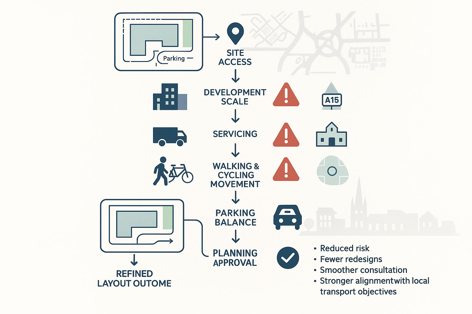
How To Prepare A Strong Transport Submission For A Planning Application
A strong transport submission is proportionate, locally informed and easy to follow. That sounds simple, but many reports fail because they are either too generic or too technical without answering the planning questions officers actually care about.
The first step is to scope the work properly and early. Identify whether the key issue is access, junction capacity, parking stress, sustainable accessibility, servicing, or a combination. Then match the level of evidence to the scale and sensitivity of the proposal. Not every site needs a huge assessment. But every site needs the right one.
From there, the essentials usually include:
- a clear description of the development and site context
- a justified decision on whether a TS or TA is required
- robust trip generation and distribution, where relevant
- access drawings with geometry and visibility information
- junction assessment or modelling where impact may arise
- parking and cycle parking strategy
- servicing and refuse arrangements, supported by tracking if needed
- sustainable accessibility review
- mitigation and Travel Plan measures where appropriate
Engagement matters too. Early discussion with Peterborough City Council and, where relevant, transport officers can help avoid wasted effort and narrow disagreement before submission.
At ML Traffic, the practical lesson we keep returning to is this: concise beats bloated, provided the evidence is sound. With over 30 years of transport engineering experience, reports tailored to local authority thresholds and real planning context tend to do far more than long generic documents. A strong submission is not about saying everything. It is about proving the important things clearly, credibly and at the right level.
Conclusion
Good transport planning is rarely flashy. It is disciplined, local, and grounded in how a place actually works. But for planning applications in Peterborough, it can be the difference between a straightforward consent path and months of avoidable friction.
The key is to start early, scope the work proportionately, and align technical evidence with local policy expectations, especially around safe access, network impact, servicing, parking, and sustainable travel. When those pieces are joined up, the transport case becomes much easier for officers and consultees to understand.
For architects, planners, developers, lawyers and councils alike, Transport Planning in Petersborough is not just a compliance task. It is part of shaping better schemes: layouts that operate properly, connections that make sense, and evidence that stands up under scrutiny.
And that is really the aim in 2026, not more paperwork, just smarter planning applications backed by transport submissions that are clear, proportionate and difficult to pick apart.
Transport Planning in Peterborough – Frequently Asked Questions
What does transport planning in Peterborough typically involve?
Transport planning in Peterborough assesses safe access, highway capacity, traffic impact, parking, servicing, and sustainable travel links, aligning proposals with the Local Transport and Connectivity Plan and Cambridgeshire & Peterborough Combined Authority policies.
Why is early transport planning important for developments in Peterborough?
Early transport input shapes site layout, access, parking, and servicing, reducing planning risk and aligning schemes with local policies. It prevents costly redesigns, supports smoother application processes, and improves development viability.
When is a Transport Statement or Transport Assessment required in Peterborough?
A Transport Statement is needed for smaller or low-impact developments, while a Transport Assessment is required for larger or complex proposals with significant traffic effects or sensitive locations, ensuring proper evaluation of access, trip generation, and network impact.
How are site access and highway impacts evaluated in Peterborough transport planning?
Evaluation includes assessing access geometry, visibility splays, junction capacity, safety, and operational performance within local context, using traffic data, swept-path analysis, and modelling to confirm compliance and mitigate network effects.
How does Peterborough’s transport planning support sustainable and active travel?
It prioritises walking, cycling, and public transport by reviewing safe, direct routes and realistic bus access, encouraging developments to maximise permeability, reduce car dependency, and align with the Local Transport and Connectivity Plan’s greener transport goals.
What are common reasons for transport objections in Peterborough planning applications?
Objections often stem from unsafe or inadequate access, insufficient assessment, unacceptable junction impacts without mitigation, improper parking or servicing arrangements, and failure to adequately support active travel and sustainable transport measures.