Planning applications are getting tougher on transport. That is not just because highways teams want more paperwork. It is because access, emissions, public health, street design, viability, and local politics now meet in one place: the transport strategy.
In practice, sustainable transport planning is no longer a nice extra attached to a Transport Assessment at the end of design. It is a core part of how we show that a development is genuinely workable. Can people reach the site without depending on a private car? Will the proposal support walking, cycling, buses, shared travel, and safer streets? Does it align with local plan policy, net zero ambitions, and the reality of how the place functions today?
For architects, planners, developers, surveyors, councils, and legal teams, the challenge is rarely understanding the principle. The difficulty is turning that principle into an application-stage strategy that is specific, evidence-led, and acceptable to decision-makers.
That is where clarity matters. We have seen plenty of schemes delayed not because the transport impacts were unresolvable, but because the submission was vague, disconnected from policy, or arrived too late to shape the layout properly. And the opposite is true as well: a well-structured sustainable transport approach can de-risk an application, strengthen negotiations, and improve the final scheme.
In this guide, we set out what sustainable transport planning means in a UK planning application context, what evidence is normally required, and how to build a robust strategy that stands up in 2026.
What Sustainable Transport Planning Means In A Planning Application Context
In a planning application context, sustainable transport planning means demonstrating that a development has been conceived, tested, and refined to reduce unnecessary travel demand, enable low-carbon journeys, and manage the remaining vehicle trips responsibly.
That sounds straightforward. It rarely is.
At application stage, we are usually being asked to do several things at once. First, we need to show that the site is accessible by a range of modes, not just by car. Second, we need to explain how the design and land use mix will influence travel behaviour. Third, we need to identify what mitigation or improvement measures are required so the network can operate safely and efficiently.
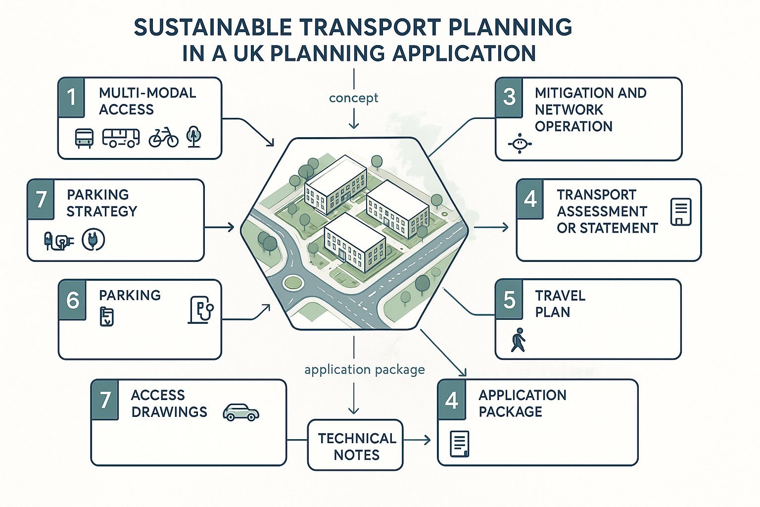
In UK planning terms, this often sits across a package of documents rather than one single report: a Transport Assessment or Transport Statement, a Travel Plan, access drawings, parking strategy, servicing information, and sometimes wider technical notes on junctions, active travel, or public transport connectivity.
The strongest submissions do not treat sustainable transport planning as a bolt-on. They build it into the site layout, frontage design, cycle provision, pedestrian links, servicing logic, and phasing. They also connect the transport story to planning policy, placemaking, and deliverability.
In other words, the question is not only, “How many trips will this generate?” It is, “How will this place function, and what transport choices will it create?” That is the standard many authorities increasingly expect.
Why It Matters For Developers, Councils, And Design Teams
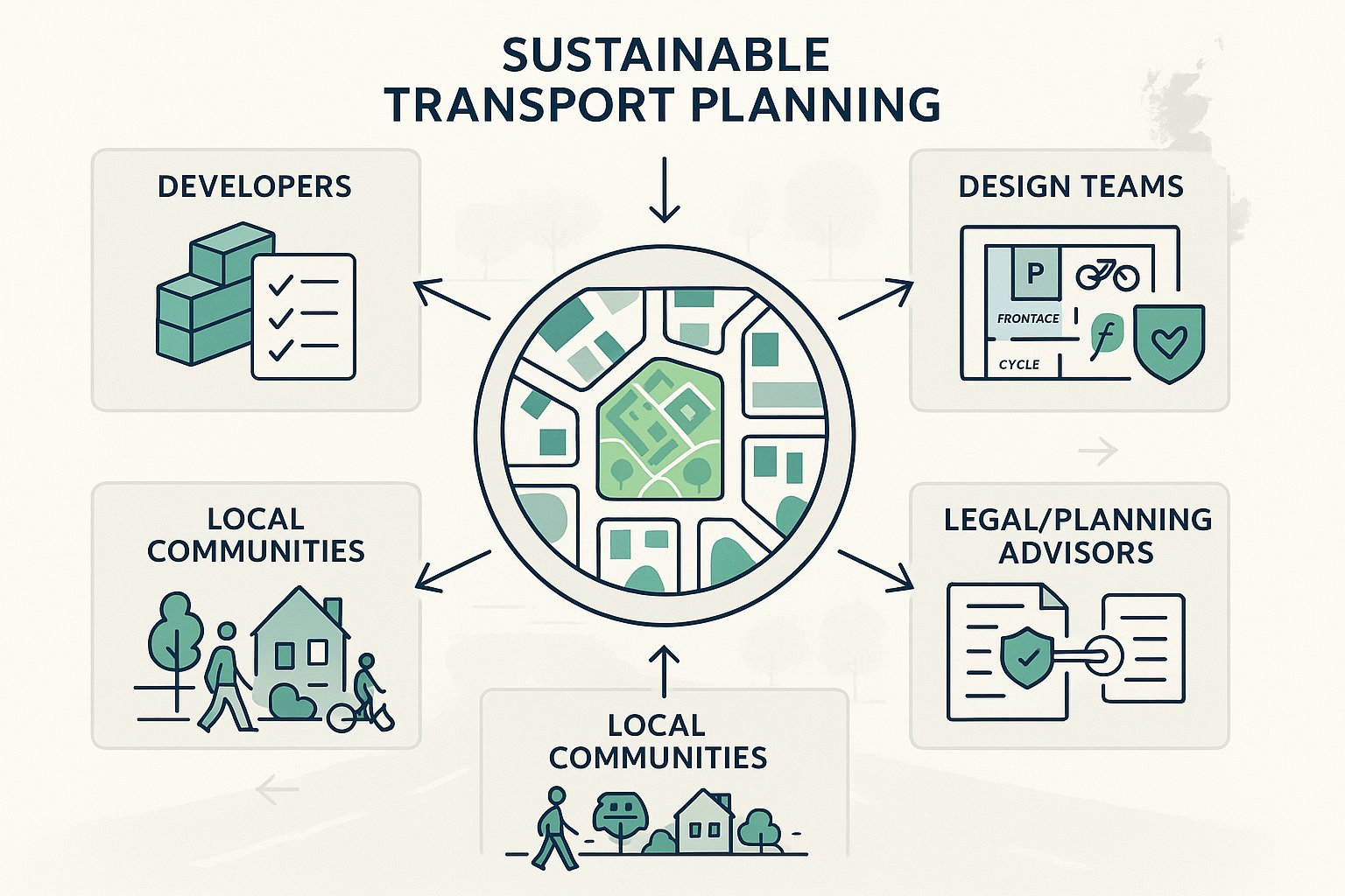
For developers, sustainable transport planning matters because it directly affects planning risk. A weak transport strategy can trigger objections, elongate negotiations, increase mitigation costs late in the process, or undermine an otherwise strong application. A good one can do the opposite: it can support the planning balance, improve credibility with officers, and help justify design choices that might otherwise be challenged.
For councils, it is about more than traffic impact. Authorities are under pressure to deliver housing and employment growth while meeting climate commitments, improving air quality, reducing road danger, and making places more inclusive. Sustainable transport planning provides a framework for deciding whether a scheme contributes to those goals or works against them.
For architects and wider design teams, it has practical consequences from day one. Site access, block structure, frontage activity, parking ratios, refuse strategy, cycle storage, and public realm all influence travel behaviour. If transport is left until the end, the scheme often inherits avoidable problems.
Lawyers and planning consultants will recognise another point: policy compliance is easier to defend when the transport evidence is coherent. Clear links between policy requirements, baseline conditions, proposed measures, and monitoring commitments can reduce ambiguity during determination and appeal.
And for local communities, though they may not phrase it this way, the issue is simple enough. They want developments that are easier to move around, safer to access, and less likely to dump avoidable traffic onto already stretched streets.
The Policy And Regulatory Framework Shaping Sustainable Transport
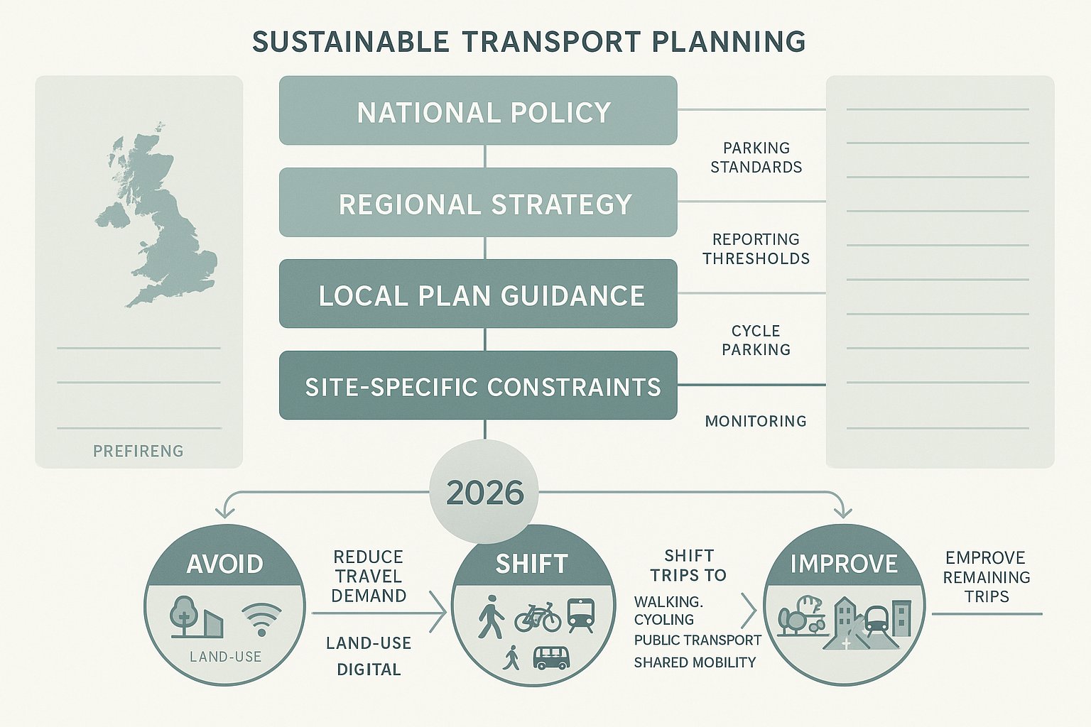
The policy framework shaping sustainable transport planning in 2026 is layered, and that layering matters. Decisions are rarely made against one policy sentence in isolation. Instead, highways officers and planning officers will usually read the proposal through national policy, regional strategies where relevant, local plan policy, supplementary guidance, parking standards, active travel expectations, and site-specific constraints.
At national level, the familiar themes remain consistent: development should promote sustainable transport modes, offer safe and suitable access for all users, and mitigate residual impacts where necessary. But the emphasis is sharper than it was a few years ago. There is less tolerance for generic statements about “encouraging” active travel if the layout, access arrangements, or parking levels suggest the opposite.
This is where the Avoid-Shift-Improve framework is useful. We can use it to structure our thinking and our evidence.
- Avoid: reduce the need to travel, especially by car, through location, mixed uses, and digital or operational measures.
- Shift: move trips towards walking, cycling, public transport, and shared travel.
- Improve: make remaining trips more efficient and less harmful through smarter management, cleaner fleets, and better street operation.
When preparing a planning submission, we need to show how the scheme responds across all three, not just one.
For applicants working across multiple authorities, local variation is the big practical issue. Thresholds, report expectations, cycle parking standards, trip-rate assumptions, and travel plan monitoring requirements can differ quite a bit. That is one reason specialist, locally tailored reporting matters. At ML Traffic, for example, the value is not just technical accuracy: it is understanding what a particular authority is likely to ask for and framing the evidence accordingly.
National, Regional, And Local Policy Drivers
National policy sets the direction, but local policy usually determines the detailed test your scheme must pass.
At the national level, the National Planning Policy Framework and associated planning guidance continue to push development towards sustainable movement patterns, safe access, and proportionate mitigation. Alongside that, Department for Transport guidance, Manual for Streets principles, active travel design expectations, and decarbonisation policy all influence how proposals are reviewed.
Regionally, the picture varies. In London, for instance, mode shift expectations, accessibility benchmarks, and parking restraint are typically stronger and more codified. In combined authority areas, Local Transport Plans and regional decarbonisation strategies increasingly shape planning conversations. Elsewhere, county-level transport strategies and infrastructure delivery plans often fill that role.
Then there is local policy, which is where many applications are won or lost. Local plans may include explicit requirements on sustainable accessibility, modal hierarchy, electric vehicle charging, cycle parking, public transport contributions, travel plan monitoring, and public realm quality. Supplementary planning documents may go further, setting out expectations around car-free or low-car development, accessibility standards, or Healthy Streets principles.
We need to read those documents carefully, not selectively. A common mistake is citing high-level sustainability policy while overlooking the authority’s detailed parking or access guidance. Another is relying on old local evidence where policy has moved on.
The best approach is to map policy requirements directly against the proposal: location, design response, trip impacts, mitigation, and monitoring. That creates a much clearer audit trail for officers and, frankly, a stronger submission overall.
How Sustainable Transport Planning Supports Net Zero, Placemaking, And Public Health
Transport remains one of the hardest sectors to decarbonise in the UK, and that is exactly why sustainable transport planning has become so central to development management. If a scheme locks in high car dependency, the emissions consequences last for decades.
But the benefits are not just carbon-related.
From a net zero perspective, development can reduce transport emissions by being in the right place, with the right density, connected to the right modes. Location still matters enormously. So does the internal logic of the site: direct walking routes, secure cycle parking, bus stop access, reduced parking dominance, and layouts that do not make active travel feel like the “secondary” option.
From a placemaking perspective, prioritising sustainable movement tends to produce better streets. Streets with lower traffic dominance are easier to cross, more pleasant to spend time in, and often more commercially resilient. Public realm quality improves when vehicle circulation is not driving every design decision.
Public health is the third pillar, and it is sometimes underplayed in planning submissions. Yet it can be powerful. Enabling walking and cycling as part of everyday journeys supports physical activity, reduces exposure to poor air quality where traffic falls, and can improve independence for children, older people, and non-drivers. Access to jobs, services, and social networks also becomes more equitable.
That is why we should think of sustainable transport planning as more than a compliance exercise. Done properly, it is a way of creating places that function better, environmentally, socially, and economically.
Core Principles Of A Strong Sustainable Transport Strategy
A strong sustainable transport strategy is clear about what the development is trying to achieve and how success will be evidenced. It is not a list of worthy ideas. It is a coordinated package tied to the site, the use, the local network, and the authority’s policy framework.
In most cases, five principles matter.
First, start with the site and its context, not a template. Existing walking routes, severance points, bus services, local destinations, topography, and safety issues should shape the strategy.
Second, align land use and movement early. If the masterplan creates long pedestrian desire lines, hidden cycle stores, or vehicle-dominated frontages, later mitigation becomes more difficult and more expensive.
Third, prioritise realistic mode shift. Targets should be ambitious but credible, supported by infrastructure, management measures, and monitoring.
Fourth, address residual car demand honestly. Sustainable transport planning does not mean pretending car trips disappear. It means reducing them where possible and managing them properly where they remain.
Fifth, build in delivery mechanisms. Officers will want to know who is responsible, when measures are triggered, how they are funded, and what happens if mode share targets are not met.
The strongest strategies feel joined-up. The transport evidence supports the urban design: the parking strategy supports the travel plan: the access arrangement supports pedestrian safety: and the monitoring framework supports enforceability. When all of that lines up, the scheme reads as intentional rather than reactive.
Prioritising Walking, Cycling, Public Transport, And Shared Travel
The mode hierarchy needs to be visible in the actual proposal, not just in the narrative.
For walking, that means direct, legible, overlooked routes with safe crossings and convenient links to nearby destinations. If a resident has to take a circuitous route through car parking to reach the street, we are not really prioritising walking.
For cycling, quality matters more than token provision. Secure, accessible cycle parking: step-free access where possible: visitor spaces in the right locations: and links into the surrounding network all make a difference. On larger schemes, end-of-trip facilities and internal route continuity become important as well.
Public transport integration should go beyond measuring distance to the nearest stop. We need to consider service frequency, journey time usefulness, pedestrian access quality, waiting environment, and whether improvements or contributions are justified. A bus stop 400 metres away on paper may still be poor in practice if the route to it is hostile.
Shared travel options can also strengthen a strategy, particularly where full car-free living is unrealistic. Car clubs, shared cycle schemes, pooled servicing, shuttle arrangements, and mobility hubs can help reduce private car ownership and make lower-car lifestyles more workable.
The key is combination. One isolated measure rarely changes behaviour. But when walking, cycling, public transport, and shared mobility are planned as a coherent package, mode shift becomes much more credible.
Integrating Land Use, Accessibility, And Street Design
Good sustainable transport planning sits at the intersection of transport engineering and urban design.
Land use affects trip patterns. A residential scheme near shops, schools, and public transport will typically perform differently from an isolated edge-of-settlement site. Mixed-use development can reduce trip lengths and support linked trips, but only if the layout makes those uses easy to reach on foot.
Accessibility is broader than distance. We should be asking who can use the route, in what conditions, and with what level of confidence. Gradients, crossing points, lighting, passive surveillance, wheelchair usability, and wayfinding all matter. So do everyday realities, parents with buggies, older people, shift workers, teenagers, delivery riders.
Street design is where these considerations become tangible. Vehicle tracking and refuse access are necessary, of course, but they should not dominate at the expense of walkability or placemaking. Junction radii, crossing widths, surface treatments, frontage activity, and parking arrangement all influence how a street feels and how people choose to move through it.
Too often, teams deal with these disciplines separately. The planner references sustainability policy, the architect finalises the layout, and the transport consultant later tries to make the movement story fit. That sequencing can be costly.
A better approach is iterative coordination from the start. When transport planning, access design, and placemaking evolve together, the final strategy tends to be both stronger on policy and more convincing technically.
Key Evidence And Assessments Needed To Support Planning Decisions
Planning authorities do not approve sustainable intent alone. They approve evidence-backed proposals.
The exact document set depends on scheme scale, use, and local thresholds, but most applications will require some combination of the following:
- Transport Assessment or Transport Statement: to explain baseline conditions, trip generation, distribution, assignment, safety, accessibility, and mitigation.
- Framework or Full Travel Plan: to set objectives, targets, measures, management responsibilities, and monitoring arrangements.
- Access strategy and drawings: covering pedestrian, cycle, vehicle, servicing, and emergency access.
- Parking justification: including car parking levels, disabled spaces, cycle parking, electric vehicle charging, and operational management.
- Technical modelling or junction assessments: where material traffic effects are possible.
- Active travel and public transport review: particularly where mode shift claims are central to the application.
The evidence needs to be current and proportionate. Baseline surveys that are outdated, seasonal without explanation, or disconnected from post-pandemic travel patterns can weaken credibility. So can stock trip rates applied without local judgement.
Importantly, evidence should tell one story. If the Design and Access Statement promises a walkable, low-car place but the transport report assumes high private car mode share and oversupplied parking, officers will notice.
This is where concise, authority-aware reporting makes a difference. Clear documentation, tailored to local thresholds and planning context, often helps decision-makers engage with the substance rather than getting stuck in avoidable clarification rounds.
Common Measures Used In Sustainable Transport Planning
Most sustainable transport strategies draw from a familiar toolkit, but the right package depends entirely on context. The objective is not to throw in every possible measure. It is to choose interventions that are relevant, deliverable, and likely to influence travel behaviour.
Common physical measures include improved pedestrian links, upgraded crossings, widened footways, cycle routes, secure cycle parking, dropped kerbs, wayfinding, and bus stop enhancements. On larger or phased developments, contributions to off-site walking, cycling, or public transport infrastructure may be necessary.
Operational and behavioural measures are just as important. These can include resident welcome packs, personalised travel information, discounted public transport offers, cycle training, school or workplace travel coordination, delivery management plans, and servicing strategies that reduce peak conflict.
Shared mobility options are becoming more mainstream too. Car club bays, parcel lockers, bike share docking, and mobility hubs can all support lower car ownership if they are properly located and managed.
Then there are demand-side controls. Parking restraint, permit management, unbundled parking, electric vehicle infrastructure, staggered hours, and remote-working support can all influence trip numbers and mode choice.
The strongest applications explain not just what is proposed, but why those measures are suitable for this site, this use, and this authority area. Specificity always beats generic aspiration.
Travel Plans, Parking Management, And Demand Reduction Measures
Travel Plans are often treated as the final appendix nobody reads. That is a mistake.
A good Travel Plan is one of the clearest ways to show that sustainable transport planning will continue beyond determination. It translates strategy into action: named coordinator, baseline surveys, target mode shares, promotion measures, review points, and remedial steps if targets are missed.
Parking management is equally important. Parking supply and management strongly influence travel behaviour, especially in residential and employment schemes. Too much parking can lock in car dependence. Too little, without local context or operational planning, can create overspill concerns and community resistance. The answer is not ideology: it is evidence. We need a parking approach that reflects accessibility, local controls, user needs, and policy.
Demand reduction measures sit alongside this. These might include:
- unbundling parking from property cost:
- prioritising disabled parking and essential operational spaces:
- allocating car club membership incentives:
- providing real-time travel information:
- supporting flexible working or staggered shift patterns: and
- managing deliveries to avoid peak periods.
Done well, these measures reduce reliance on network capacity rather than simply trying to accommodate ever more traffic.
And they help at application stage because they demonstrate active management. Officers are usually more comfortable with ambitious mode shift assumptions when there is a credible package of controls, incentives, and monitoring behind them.
How To Deliver A Robust Strategy That Stands Up At Application Stage
If we want a sustainable transport strategy to stand up during validation, consultation, negotiation, and determination, we need to build it early and build it coherently.
Start with a proper baseline. That means understanding the site’s catchment, surrounding land uses, pedestrian and cycle conditions, public transport quality, collision history where relevant, parking context, and local policy expectations. Not in broad brush terms, in detail.
Next, coordinate with the design team before the layout hardens. Access points, block structure, internal routes, servicing, cycle storage, and public realm should all be tested against the movement strategy. This is where many avoidable conflicts can still be designed out.
Then align the evidence package. The Transport Assessment, Travel Plan, planning statement, Design and Access Statement, drainage strategy, and landscape approach should reinforce each other rather than create mixed messages.
Engagement matters too. Early discussion with the local planning authority and highway authority can flush out issues on scope, thresholds, junction modelling, parking assumptions, or travel plan expectations. That will not eliminate disagreement, but it usually improves efficiency.
Finally, be measurable. Set realistic targets, identify trigger points, define responsibilities, and explain monitoring. If off-site works or contributions are needed, be clear about purpose and relationship to impact.
In our experience, robust application-stage transport work is rarely about flashy modelling. It is about disciplined coordination, local awareness, and a strategy that reads as though the team actually intended to deliver it.
Common Pitfalls That Delay Approval Or Weaken A Submission
Most weak submissions do not fail because sustainable transport planning is impossible. They fail because the evidence is thin, contradictory, or too late.
One common pitfall is weak baseline data. If surveys are old, unrepresentative, or poorly explained, every later conclusion becomes easier to challenge. The same goes for generic trip generation assumptions that ignore local mode share, accessibility, or site-specific characteristics.
Another is policy misalignment. We still see reports that cite broad sustainability ambitions while overlooking detailed local standards on parking, cycle provision, travel plans, or accessibility. Officers will usually focus on that local detail.
Vague targets are another problem. Promising to “encourage sustainable travel” without defining measures, responsibilities, funding, or monitoring carries little weight. A Travel Plan with no delivery mechanism is barely a plan at all.
Siloed coordination can be just as damaging. If the architect has designed a pedestrian-unfriendly frontage, the transport consultant cannot paper over it with warm words about active travel. Likewise, if servicing sweeps through the main public realm route, the place is telling a different story from the report.
Late-stage transport input is perhaps the biggest issue. By the time layouts, parking, and site access are fixed, the opportunity to create genuine mode shift may already have been lost.
The practical takeaway is simple: start early, use robust evidence, read the local policy properly, and make sure the strategy is embedded in the design rather than attached to it at the end.
Sustainable transport planning is now a central test of development quality. In 2026, schemes that succeed will usually be the ones that treat it that way from the outset, as part of placemaking, policy compliance, and delivery, not just traffic management. When the evidence is locally grounded, the measures are realistic, and the reporting is clear, the planning process tends to move more smoothly. And the finished development tends to work better too.
That is eventually the point. We are not only trying to satisfy a validation checklist. We are trying to create places people can reach, use, and live with more easily. If the transport strategy helps do that, it is doing its job.
Frequently Asked Questions on Sustainable Transport Planning
What does sustainable transport planning involve in a UK planning application?
Sustainable transport planning in the UK means showing that a development reduces unnecessary travel, encourages low-carbon modes like walking and cycling, and responsibly manages remaining vehicle trips through evidence-led, policy-aligned strategies.
Why is sustainable transport planning important for developers and local authorities?
It reduces planning risks for developers by strengthening applications and supports councils in meeting climate, health, and safety goals by promoting accessible, low-emission transport and managing road impacts effectively.
How does the Avoid-Shift-Improve framework guide sustainable transport planning?
It helps structure strategies by aiming to avoid unnecessary travel, shift trips to walking, cycling, public or shared transport, and improve efficiency of remaining vehicle journeys to lower emissions and congestion.
What key evidence is typically required to support sustainable transport planning in a planning application?
Essential evidence includes a Transport Assessment or Statement, a Travel Plan, access and parking strategies, and sometimes technical notes on active travel or junctions, all tailored to local policy and site context.
How can sustainable transport planning contribute to net zero and public health objectives?
By prioritising low-carbon travel modes and integrating walkable design, it reduces transport emissions, improves air quality, encourages physical activity, and creates more equitable, safer communities.
What common pitfalls should be avoided when preparing a sustainable transport strategy for planning?
Avoid weak or outdated data, unclear targets, poor coordination between design and transport, ignoring local detailed policies, and lack of monitoring, as these can delay or weaken planning approval.