A shop transport assessment can look deceptively straightforward on paper: count some trips, check the junctions, add a few parking tables, and move on. In practice, planning authorities in 2026 expect something sharper. They want evidence that reflects the actual retail format, the local street network, servicing realities, accessibility by non-car modes, and whether the proposal can operate safely without creating avoidable pressure on surrounding roads.
That matters because retail schemes are rarely judged on floorspace alone. A modest convenience store can create more intense short-stay traffic than a larger comparison goods unit. A town-centre shop with strong bus links may need a very different assessment from an out-of-centre retail unit with heavy car dependence. And when a site sits near a constrained junction, school route, Air Quality Management Area, or already stressed high street, transport evidence quickly becomes central to the planning decision.
In our experience, the strongest submissions are proportionate but not superficial. They respond to local thresholds, explain assumptions clearly, and deal with the issues officers and highway authorities are already worrying about. That is exactly where a well-prepared shop transport assessment helps.
Below, we set out what a shop transport assessment is, when it is usually needed, what planning authorities tend to examine, and how to improve the chances of a smoother planning process in 2026.
What A Shop Transport Assessment Is And When It Is Needed
A shop transport assessment is a formal transport study submitted alongside a planning application to identify, quantify, and evaluate the transport effects of a proposed retail development. Its purpose is not simply to predict traffic. It also considers accessibility, road safety, servicing, parking demand, and whether mitigation is needed to make the scheme acceptable in planning terms.
In the UK planning system, a full Transport Assessment is generally required where a proposal is likely to create significant movement. Where impacts are expected to be more limited, a Transport Statement may be sufficient. The dividing line is not fixed nationally for every retail scheme. Instead, local validation requirements, local plan policies, and highway authority guidance often determine what level of evidence is expected.
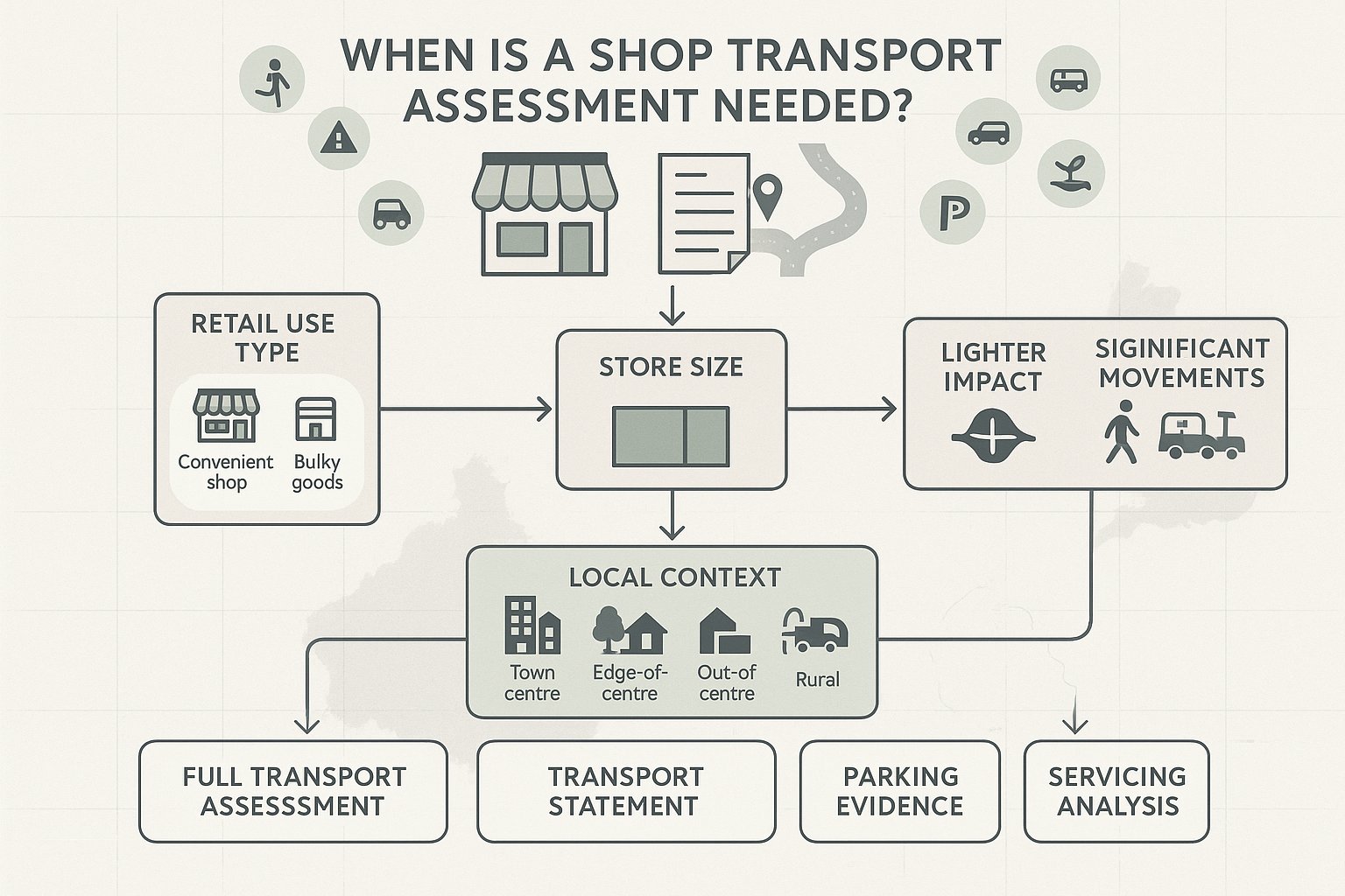
For shop developments, that judgment usually turns on three things: the nature of the retail use, the scale of the proposal, and the sensitivity of the location. A relatively small unit can still trigger transport work if it sits on a constrained frontage road, relies on awkward servicing, or is expected to attract frequent short-stay turnover. Equally, some larger schemes in highly accessible centres may still be capable of being assessed proportionately if their impacts are modest and well understood.
In other words, the right question is rarely, “Do we need a report at all?” It is usually, “What level of transport evidence will the authority reasonably expect for this specific shop proposal?”
How Retail Use Class, Store Size, And Local Context Affect Requirements
Retail is not one homogenous land use, and planning authorities know it. A convenience store, discount foodstore, boutique high-street unit, bulky goods warehouse, and mixed-use ground-floor retail parade can produce very different trip patterns. That is why a shop transport assessment must reflect the actual trading format rather than rely on generic assumptions.
Store size still matters. Gross floor area is usually the starting point for estimating trip generation, often using TRICS data and local evidence where available. But floorspace alone never tells the whole story. A smaller food-led unit may generate higher peak turnover, more delivery activity, and stronger parking demand than a larger comparison retail shop.
Local context is equally important. Town-centre and edge-of-centre sites may benefit from stronger walking, cycling, and public transport mode share. Out-of-centre retail can be much more car-dependent and may place greater pressure on key junctions. Rural locations often raise accessibility concerns even where traffic volumes appear manageable.
Use class, size, and context together shape whether an authority asks for a full TA, a lighter Transport Statement, supplementary parking evidence, or detailed servicing analysis. We usually find that early review of local thresholds avoids the most common mistake: under-scoping the work and then having to retrofit evidence later.
Why Transport Evidence Matters For Shop Planning Applications
Transport evidence matters because it sits at the point where planning policy, highway operation, and day-to-day retail function meet. A shop can be acceptable in design, principle, and commercial terms, yet still run into difficulty if the application does not show how customers, staff, deliveries, and servicing vehicles will use the site safely and efficiently.
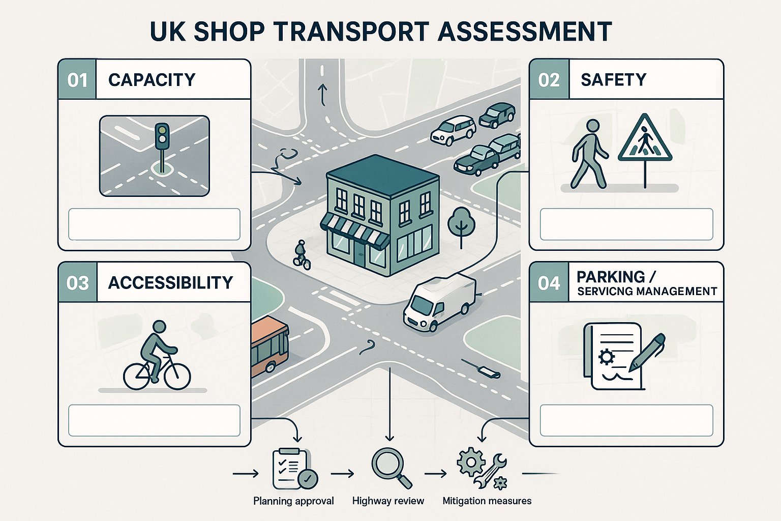
Planning authorities and local highway authorities typically want to see clear evidence on four broad issues: capacity, safety, accessibility, and parking/servicing management. Can the surrounding network absorb the extra trips? Will pedestrians and cyclists be exposed to greater conflict? Is the site reasonably accessible by sustainable modes? And are parking and loading arrangements realistic for the proposed operator and format?
These points link directly to the National Planning Policy Framework and local transport policies. In 2026, there is continued emphasis on proportionate evidence, sustainable travel, and avoiding severe residual cumulative impacts on the road network. Retail proposals that ignore those themes tend to attract delay, requests for further information, or outright objection.
A good transport assessment also helps define mitigation early. That may include junction improvements, revised access geometry, crossing upgrades, delivery management, cycle parking, or a travel plan. In many cases, it shapes conditions and legal agreements under section 106 or section 278.
Just as importantly, transport evidence gives decision-makers confidence. If assumptions are transparent, surveys are sound, and mitigation is practical, the planning conversation becomes much easier. Instead of debating whether impacts have been understood at all, everyone can focus on whether the proposed response is proportionate and effective.
Key Triggers That Can Lead To A Transport Assessment Or Transport Statement
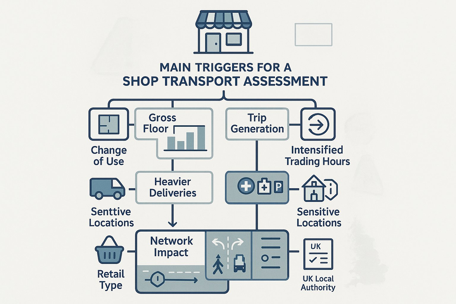
The most obvious trigger is scale. If a proposed shop exceeds local gross floor area thresholds, or if forecast trips move beyond the authority’s normal screening levels, a Transport Assessment or Transport Statement is likely to be required. But in practice, retail schemes are often triggered by a wider set of circumstances than applicants first expect.
A change of use can do it. So can an intensification of an existing shop where opening hours extend, delivery patterns become heavier, or customer turnover increases sharply. Authorities will also look closely at schemes in sensitive locations: near congested junctions, schools, hospitals, controlled parking zones, Air Quality Management Areas, or narrow streets where loading already causes friction.
For retail, the type of operation matters a lot. Food retail, drive-thru-related formats, discount operators, and roadside convenience sites commonly produce strong short-stay demand and higher vehicular activity than a simple floorspace comparison suggests. A modest proposal can hence trigger meaningful transport analysis if the use profile is intense.
Another trigger is site complexity. Shared access with neighbouring uses, poor visibility, reliance on reversing service vehicles, or interaction with heavy pedestrian flows can all justify a fuller assessment, even where total trip numbers are not especially large.
The practical lesson is simple: never screen a retail application on floorspace alone. Planning authorities rarely do.
Gross Floor Area, Trip Generation, And Local Authority Thresholds
Gross floor area remains the usual starting point because it gives a measurable basis for estimating trip generation. Using TRICS or comparable evidence, we can derive likely arrival and departure rates, then test how those trips affect the local network. But local authority thresholds vary, sometimes significantly, and retail categories are not always treated equally.
Many authorities set lower thresholds for convenience retail than for comparison goods because food shopping tends to produce more frequent car-based trips, stronger peak spreads, and more intensive parking turnover. Retail parks, roadside schemes, and locations with weak sustainable access may also attract stricter scrutiny. Some councils publish clear validation checklists: others rely more heavily on pre-application advice and case-by-case judgment.
Trip generation itself should never be a mechanical exercise. We need to consider pass-by and linked trips, existing lawful use, local competition, catchment characteristics, and whether the proposed operator is likely to draw from nearby residential areas or a wider drive-time market. Get that wrong and the rest of the assessment starts to wobble.
This is one area where local knowledge really pays off. At ML Traffic, for example, the value is often in matching national database evidence to local thresholds and planning context rather than just producing a generic trip-rate spreadsheet. Authorities can spot the difference quickly.
Primary Factors Assessed For A Retail Development
A retail-focused transport assessment is usually built around a fairly consistent set of questions, though the emphasis changes by site. Authorities want to understand not just how many trips a shop will create, but also how those trips behave across the day, where they enter and leave the network, whether the access works safely, and how sustainable modes are accommodated.
For most shop schemes, the assessment covers:
- forecast vehicle trips by time period
- trip distribution and assignment on the local network
- junction capacity and queueing effects
- access design and visibility
- delivery and servicing arrangements
- car and cycle parking demand
- pedestrian, cycle, and public transport accessibility
- road safety and conflict with vulnerable users
Retail brings particular quirks. The busiest period on the road network may not match the busiest period in-store. Some schemes generate high levels of pass-by traffic: others rely on deliberate destination trips. Staff parking can be modest in one format and material in another. Deliveries might be small and frequent, or less frequent but HGV-based and operationally awkward.
A robust assessment hence needs to move beyond generic checklists. It should reflect how the proposed shop is likely to trade in real conditions, on that specific site, within that local network.
Vehicle Trips, Delivery Activity, Parking Demand, And Servicing
This is usually the technical core of the report. We assess how many vehicle trips the shop is likely to generate during daily and peak periods, then test what those movements mean for nearby junctions and access points. For retail, it is often important to distinguish between total trips and new trips, especially where pass-by or linked shopping trips reduce the net effect on the wider network.
Delivery activity matters just as much. A compact urban shop can function poorly if servicing is not resolved, even where customer traffic impacts are modest. Authorities often focus on HGV routing, delivery frequency, loading bay dimensions, swept path analysis, and whether vehicles can enter and leave in a forward gear. If loading is proposed from the highway, the justification needs to be very strong.
Parking assessment also needs realism. We typically review likely demand by customer and staff category, duration of stay, turnover, local parking controls, and nearby competing demand. For convenience stores, short-stay pressure can be intense. For high-street units, the question may be whether existing public parking and sustainable access reduce the need for dedicated on-site provision.
Servicing plans, delivery time controls, and management measures are often what unlock a difficult retail application. Not glamorous, admittedly, but planners and highway officers care because these are the arrangements that determine whether a scheme works at 8.15 on a wet Tuesday, not just on a layout drawing.
Walking, Cycling, Public Transport, And Accessibility
In 2026, no credible shop transport assessment can focus only on cars. Planning authorities expect us to show how the proposal performs for people arriving on foot, by cycle, or by public transport, and whether the location aligns with broader policy support for sustainable travel.
That means reviewing pedestrian catchments, footway width, crossing opportunities, dropped kerbs, lighting, gradient, personal security, and connections to surrounding streets. For cyclists, we look at route quality, traffic stress, cycle parking quantity and design, and how riders move through the site. Public transport assessment usually covers bus stops, rail access where relevant, service frequencies, walking routes to stops, and the practical attractiveness of those options.
For town-centre shops, this can be a major strength. Good accessibility by non-car modes may help support lower parking provision and a more policy-compliant case. For out-of-centre schemes, the sustainable access story often needs more work: better crossings, upgraded footways, bus stop improvements, cycle links, or a credible travel plan.
Accessibility is not just a policy box-tick. It often changes the traffic outcome. If a site is genuinely well connected, mode share assumptions can be more robust and car dependence lower. But authorities will expect evidence, not aspiration. A dashed line on a plan is not the same thing as a safe, convenient, and legible route that people will actually use.
How A Shop Transport Assessment Is Prepared
A sound assessment starts with scope. Before modelling anything, we need to understand what the authority is likely to care about: the local thresholds, the key junctions, the survey requirements, the peak periods, and whether the proposal should be assessed as a full TA or a lighter statement. Early engagement with the local highway authority can save weeks of avoidable rework.
From there, the process usually moves through baseline data collection, trip generation, distribution and assignment, capacity testing, accessibility review, and mitigation design. Existing use is important too. Where a lawful retail or commercial use already operates on the site, the assessment should identify the realistic fallback position rather than treating everything as net new impact.
The best reports are proportionate. They do not drown a small shop application in unnecessary modelling, but they also do not skip over obvious risks such as delivery conflicts, constrained accesses, or nearby junction stress. A clear narrative matters. Decision-makers should be able to follow the logic from survey data to forecasts to conclusions without feeling they have to decode an engineering puzzle.
For planning teams, timing is often the hidden issue. Transport work affects layout, servicing, parking, swept paths, and mitigation costs. Leave it too late and the assessment becomes reactive. Bring it in early and it can shape a scheme that is easier to consent.
Surveys, Traffic Data, Junction Capacity, And Site Access Review
The technical backbone of a shop transport assessment is good baseline evidence. Depending on the proposal, that may include automatic traffic counts, turning counts at nearby junctions, queue length observations, parking beat surveys, pedestrian and cycle counts, and public transport audits. Retail sites often need survey periods that capture genuine shopping conditions rather than unusually quiet or distorted trading days.
We then establish traffic forecasts. That usually means building base scenarios, applying background growth, accounting for committed developments, and adding development traffic based on appropriately selected trip rates. Junction modelling may involve priority, signalised, roundabout, or network software depending on the local highway layout. The aim is not to produce numbers for their own sake: it is to identify whether residual impacts are acceptable and, if not, what mitigation would solve the problem.
Site access review is another critical step. We assess visibility splays, geometry, entry radii, pedestrian crossing desire lines, internal circulation, and whether service vehicles can manoeuvre safely. On many retail applications, access and servicing are the deciding issues.
The final report should draw those strands together clearly: what the site conditions are, what the development adds, what the network can absorb, and what measures are proposed to keep operation safe and efficient.
Common Planning Issues For Shops And How They Are Addressed
Retail schemes tend to attract a recognisable set of transport concerns. Some are strategic, like pressure on a roundabout or signal junction. Others are very local and operational: vans blocking the carriageway, customers queuing into a tight access, or pedestrians crossing where the layout never quite anticipated them. The challenge is that small frictions can become planning objections if they are not dealt with properly.
One common issue is underestimating operational intensity. Applicants sometimes assume a modest floorspace means modest impact, but convenience-led retail can generate rapid turnover, short dwell times, and recurring delivery activity. Another is treating parking as a simple standards exercise when actual demand depends on local controls, nearby land uses, mode choice, and store format.
There is also the policy dimension. Authorities increasingly expect shop proposals to support walking, cycling, and public transport, especially in centres and edge-of-centre locations. So even when highway capacity is acceptable, poor sustainable access can still weaken the overall planning case.
The good news is that most recurring transport issues are manageable if identified early. Clear servicing strategies, access refinements, parking management, crossing improvements, and proportionate mitigation often make the difference between an objection and a workable recommendation.
High Street, Out-Of-Centre, Convenience, And Mixed-Use Retail Considerations
High-street shop proposals often face constrained streets, limited on-site parking, strong pedestrian activity, and awkward servicing windows. Here, the transport solution is usually about management as much as infrastructure: timed deliveries, loading controls, strengthened crossing points, footway protection, and realistic assumptions about customer travel behaviour.
Out-of-centre and retail park schemes raise a different set of issues. Car mode share is often higher, junction impacts can extend further into the strategic network, and walking routes may be indirect or unattractive. In those cases, authorities commonly expect more detailed junction analysis plus tangible sustainable access improvements rather than a generic promise to encourage non-car travel.
Convenience retail has its own profile again. These stores can attract significant pass-by trade, fast turnover, and pressure for very short-stay parking. If the access arrangement is unclear or the bays are poorly designed, operational problems show up quickly. Delivery timing controls, clear circulation, and carefully designed short-stay provision can help a lot.
Mixed-use retail schemes add another layer because parking, servicing, and trip patterns interact across uses. Shared parking may be efficient, but only if accumulation analysis demonstrates it. Residential or commercial neighbours can also create sensitivity around servicing hours and access design. A joined-up, multi-modal assessment is usually essential.
How To Improve The Chances Of A Smooth Planning Decision
If we want a smoother planning decision, the best move is nearly always to engage early and scope properly. That means speaking with the local highway authority before the application is fixed, agreeing survey extents where possible, checking local thresholds, and identifying whether the authority expects a full TA, a Transport Statement, a travel plan, or targeted supporting notes on parking and servicing.
The next step is proportionality with substance. Thin evidence invites challenge: bloated evidence can obscure the real issues. The aim is a report that is concise but robust, clearly tied to local and national policy, and honest about where mitigation is needed. Highway officers are far more receptive when assumptions are transparent and difficult points are addressed directly rather than buried.
Design integration matters too. Transport should not be left to justify a layout that is already fixed and flawed. If access geometry, delivery space, pedestrian routes, cycle parking, or internal circulation are weak, it is better to amend the scheme early than defend the indefensible later.
And finally, treat mitigation as part of the proposal, not an afterthought. Junction works, crossing upgrades, delivery management plans, and a realistic Retail Travel Plan often give authorities the confidence that impacts can be controlled in practice.
In our experience, shop applications move more smoothly when the transport evidence feels locally tuned, commercially realistic, and planning-aware. That combination is what turns a report from a validation document into a useful decision-making tool.
Shop Transport Assessment FAQs
What is a shop transport assessment and when is it required?
A shop transport assessment is a formal study submitted with a planning application to evaluate transport impacts of retail developments. It is required when proposals are expected to generate significant movements, based on use class, gross floor area, and local authority thresholds.
How do retail use class, store size, and location affect transport assessment requirements?
Use class and format influence trip rates and mode share; store size (gross floor area) guides trip generation estimates, while local context like town centre or out-of-centre affects car dependence and accessibility. These factors determine the level of transport evidence needed.
Why is transport evidence important for planning retail shops?
Transport evidence demonstrates that a retail scheme can operate safely and efficiently without undue pressure on roads. It covers network capacity, safety, accessibility, and parking and supports planning policies ensuring sustainable travel and mitigating impacts.
What transport aspects are assessed in a shop transport assessment?
Assessments cover vehicle trip generation and distribution, junction capacity, site access safety, servicing and delivery logistics, parking demand, and accessibility by walking, cycling, and public transport to provide a comprehensive evaluation.
How can early engagement with local highway authorities improve shop transport assessments?
Early consultation helps define appropriate scope, local thresholds, and survey needs. It ensures proportionate evidence, aligns with local policies, and reduces rework, increasing the likelihood of a smooth and timely planning decision.
What are common transport challenges for different retail locations like high-street and out-of-centre shops?
High-street shops face constrained streets, limited parking, and pedestrian conflicts managed by servicing plans and crossing improvements. Out-of-centre shops often have high car trip levels needing junction upgrades and strong sustainable access measures to reduce impact.