
A development site can look straightforward on a red-line plan and still unravel the moment technical work begins. The access is tighter than expected. Drainage outfalls are awkward. A utility easement cuts through the ideal building footprint. Refuse vehicles cannot turn. Suddenly, what looked viable in principle starts absorbing time, fees and political capital.
That is why infrastructure engineering for developers matters so much in property development. It is not a bolt-on discipline brought in after the architecture is fixed. It is the practical framework that makes land usable, safe, serviceable and, crucially, consentable. When we deal with infrastructure early, we are not just drawing roads and pipes. We are testing whether a scheme can function in the real world and stand up to scrutiny from planning officers, highway authorities, drainage consultees, utilities providers and local communities.
For architects, planners, surveyors, lawyers, builders, developers and councils, the benefit is simple: better technical coordination means fewer surprises later. In 2026, with tighter planning expectations, stronger SuDS scrutiny and increasing pressure on transport evidence, early infrastructure thinking is often the difference between a smooth planning route and a slow, expensive redesign loop.
In this guide, we set out what infrastructure engineering means in practice, why early input changes outcomes, which technical areas need the closest coordination, and how the right evidence base supports planning applications and delivery with less friction.
What Infrastructure Engineering Means In Property Development

Infrastructure engineering in property development is the planning, design and delivery of the physical systems that allow a site to operate. That includes access roads, junctions, footways, cycle links, parking, servicing areas, drainage networks, utilities, levels and the interfaces with surrounding public infrastructure.
In practical terms, it sits at the point where vision meets constraint. A masterplan may show attractive buildings and generous public realm, but infrastructure engineering tests whether vehicles can enter safely, whether emergency access works, whether surface water can be attenuated, whether foul drainage has a viable connection, and whether utility corridors can be installed without undermining everything else.
This is why infrastructure engineering for developers should be treated as a core viability input, not simply a detailed design exercise. It shapes site capacity, plot arrangement, frontage treatment, adoption strategy, cost planning and programme risk.
It also reaches beyond technical compliance. Well-planned infrastructure improves sales value, operational efficiency and long-term asset performance. Badly planned infrastructure does the opposite: awkward servicing, drainage problems, vehicle conflict, expensive remedial works and prolonged negotiations with authorities.
From our perspective, the strongest schemes are the ones where highways, drainage, utilities and movement strategy are considered alongside architecture and planning policy from the outset. That early alignment creates development proposals that are not just appealing on paper, but buildable and defensible.
Why Early Infrastructure Input Reduces Planning And Delivery Risk

Early infrastructure input saves far more than design time. It protects the whole project from avoidable missteps that tend to surface late, when changing direction is costly.
The first benefit is constraint discovery. Access limitations, visibility issues, flood pathways, culvert easements, utility diversions, statutory undertaker capacity, retaining requirements and abnormal earthworks can all materially affect a scheme. Finding those issues before land commitments harden or layouts are overdeveloped gives the team options.
The second benefit is design realism. It is one thing to fit units onto a site: it is another to make them work with refuse tracking, ambulance access, parking standards, pedestrian desire lines and drainage corridors. Early infrastructure input helps shape layouts that can survive technical review rather than being repeatedly value-engineered after objections arrive.
The third is planning confidence. Local authorities increasingly expect transport, drainage and access matters to be addressed with a clear evidence base at application stage. Strong upfront technical work can reduce holding objections, shorten consultation cycles and limit the need for reactive revisions. In many schemes, a well-scoped traffic impact assessment is part of that early risk control, because trip generation, junction effects and mitigation often shape planning discussions earlier than teams expect.
And there is a commercial angle. Re-design costs, delayed conditions discharge, utility surprises and off-site highway works can erode margins quickly. Early engineering will not remove every risk, but it makes those risks visible while decisions are still cheap.
The Core Infrastructure Areas Developers Need To Coordinate

The phrase sounds broad because the scope is broad. But in most UK developments, three areas repeatedly drive planning outcomes and delivery complexity: highways and access, drainage and utilities, and the wider movement and servicing strategy. They overlap more than teams sometimes assume, which is why siloed working causes trouble.
A small access adjustment can alter drainage falls. A utility corridor can compromise tree retention. A servicing route can remove parking or affect pedestrian comfort. Good coordination means resolving those interfaces early, before they become competing technical notes attached to a stressed planning application.
Highways And Site Access
Highways and site access are usually the first visible test of whether a scheme is workable. Authorities want to know that people can enter and leave safely, that visibility splays are achievable, that junction geometry is appropriate, and that the site connects sensibly to the surrounding network.
This goes well beyond drawing a bellmouth. We need to consider road hierarchy, carriageway widths, pedestrian crossing points, cycle movements, emergency access, parking arrangement, refuse collection, delivery vehicles and whether roads are intended for adoption or private management. Small dimensional issues often have outsized consequences.
The standard of design matters too. A proposal that ignores local authority expectations on radii, forward visibility or tracking rarely moves smoothly through review. Detailed thinking around highway infrastructure design can make the difference between a technical discussion and a planning standoff.
For constrained urban sites, this is even sharper. Existing street trees, frontage activity, loading restrictions and neighbouring accesses all have to be balanced. We often find that access strategy is not merely a transport matter: it is a placemaking and viability issue wrapped into one.
Drainage And Utilities
Drainage and utilities are sometimes underappreciated until they become the reason a layout changes. Yet they are fundamental to whether development can be serviced efficiently and lawfully.
On drainage, the core questions are familiar but rarely simple: where does surface water go, at what rate, through what system, and with what exceedance strategy if part of that system fails? SuDS expectations are now stronger, and authorities are generally looking for a coherent strategy around attenuation, infiltration feasibility, water quality, maintenance and discharge hierarchy rather than a token plan with oversized pipes.
Foul drainage can be just as decisive. Existing network capacity, pumping requirements, connection points and phasing implications need checking early. Add level changes, basements or tight easements, and the design challenge grows quickly.
Utilities bring another layer: electricity demand, gas where relevant, telecoms, water supply, heat network opportunities, diversions and statutory undertaker constraints. A substation location or diverted main can consume valuable developable area if no one has planned for it. Early utility searches and provider dialogue are not glamorous, but they are often what keep later-stage programmes honest.
Transport, Movement, And Servicing
A site can technically have access and still perform badly if the wider movement strategy is weak. This area looks at how people and vehicles move to, from and within the development over the course of a normal day.
That includes pedestrian permeability, cycle storage and routes, public transport accessibility, servicing strategy, refuse collection, drop-off behaviour, courier activity and, for larger schemes, the way trip demand is managed. A development that claims sustainability without usable walking links or credible public transport integration tends to attract justified scepticism.
Servicing deserves special attention. Retail, industrial, residential and mixed-use schemes all generate operational movements that need space and control. If a delivery vehicle blocks a key route, or refuse collection requires unsafe reversing, that problem does not disappear after planning permission is granted.
In urban locations, local experience matters. Understanding authority expectations, network sensitivities and local thresholds can sharpen the advice enormously: that is one reason targeted support such as Manchester Highway Engineering can be useful when planning submissions need to reflect place-specific technical concerns. Movement planning is not just about compliance. It is about making the completed place work every day.
How Infrastructure Engineering Supports Planning Applications
Planning applications succeed more often when the technical story is clear, evidenced and coordinated. Infrastructure engineering provides a large part of that story.
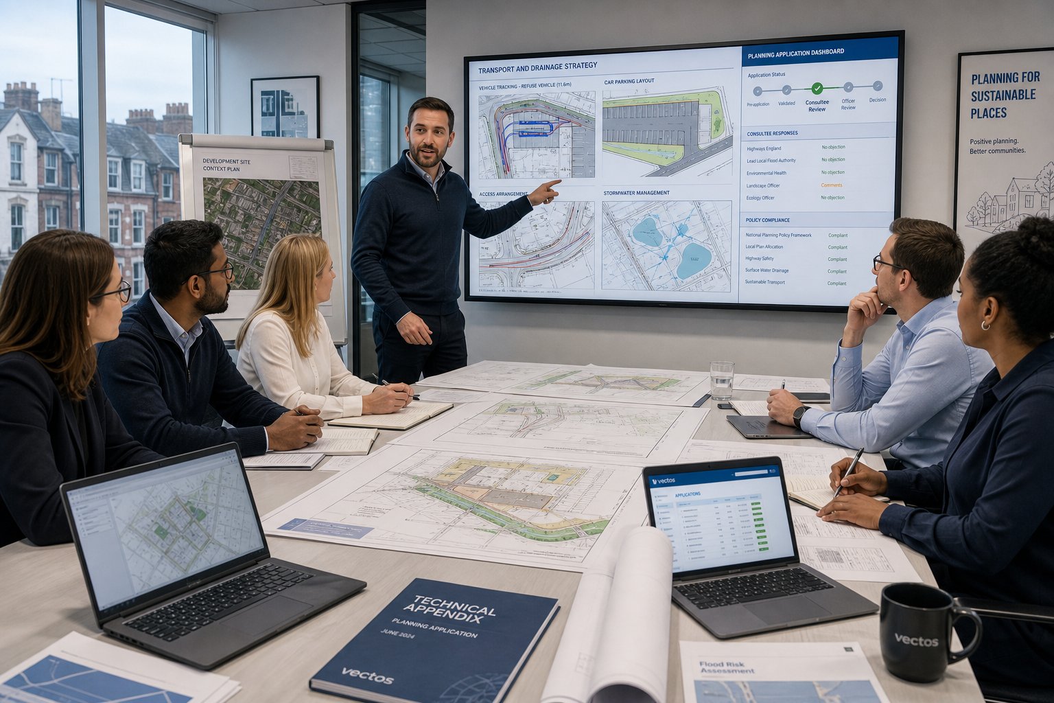
At application stage, engineers help demonstrate that the development is safe, functional and policy-compliant. They translate site constraints into drawings, strategies and reports that planners, highway officers, LLFAs and other consultees can review. Without that technical layer, even a well-conceived scheme can appear speculative.
The role starts with evidence. Access geometry, vehicle tracking, visibility, trip generation, parking provision, drainage logic, levels strategy and utility assumptions all need to be set out with enough precision to show that the proposal is credible. Authorities do not expect every nut and bolt at planning stage, but they do expect proof that the fundamentals work.
It also supports negotiation. When objections arise, they are often focused on transport safety, runoff rates, servicing conflict or network capacity. Robust engineering material allows the team to respond with reason rather than assertion. That tends to improve the quality of dialogue with consultees and can reduce the risk of conditions becoming overly restrictive.
There is a sequencing benefit too. Good infrastructure input helps planning teams anticipate what will matter later at reserved matters, technical approval or condition discharge. We have seen many projects where early coordination trimmed weeks or months from post-consent work simply because the big issues were addressed upfront rather than parked.
In short, infrastructure engineering for developers provides the technical backbone of a planning case. It turns “this should work” into “this has been tested and can be delivered”.
Key Surveys, Assessments, And Technical Reports
No serious development moves smoothly on assumptions alone. Surveys, assessments and technical reports are what convert early ideas into a defensible planning submission and a more reliable delivery plan.
The right package varies by scale, land use and location, but the principle is consistent: gather enough accurate evidence early enough to influence design, not merely justify it after the fact. At minimum, many schemes will need topographical information, utility records, basic ground understanding and transport, drainage or access documents proportionate to likely planning concerns.
Timing matters. A late survey is not just a late report: it can trigger redesign across architecture, landscape, levels, drainage and highway geometry. That is why experienced teams scope these documents in relation to planning milestones, authority thresholds and the likely questions each consultee will ask.
Transport Assessments And Travel Planning
Transport Assessments and Travel Plans are often central to planning applications because they explain how the development interacts with the surrounding network and whether any mitigation is needed. For some smaller schemes, a concise transport statement may be enough. For larger or more sensitive proposals, a fuller evidence base is expected.
Typical components include baseline site context, accessibility review, trip generation, trip distribution, junction impact analysis, parking provision, servicing arrangements and an assessment of walking, cycling and public transport connections. The quality of judgment matters as much as the raw data. A technically correct document that ignores local authority concerns can still stall progress.
Travel planning adds the demand-management side: measures that encourage sustainable travel patterns once the site is occupied. That might include cycle facilities, public transport information, car club support, welcome packs or monitoring commitments, depending on the scheme.
For developers, the practical value is not just policy compliance. These reports help identify whether network mitigation, access revisions or operational changes are needed before they become painful late-stage surprises. On schemes where timescales are tight, concise and authority-aware reporting can materially improve planning momentum.
Drainage Strategies And Flood-Related Documents
Drainage documentation has become more important with every passing planning cycle. Authorities want to understand not just whether runoff can be managed, but how the proposed approach reflects SuDS principles, greenfield or restricted discharge rates, maintenance requirements and flood resilience.
A drainage strategy usually addresses existing site conditions, proposed surface water management, storage volumes, discharge points, allowable runoff rates and the rationale for selecting particular components such as swales, basins, permeable paving or underground attenuation. The best strategies are coordinated with levels, landscape and road design, because drainage never sits neatly on its own.
Depending on flood context, developers may also need a Flood Risk Assessment, exceedance routing information or supporting material tied to national policy tests. Sites affected by ordinary watercourses, critical drainage areas or constrained outfalls often require especially careful explanation.
The common mistake is to treat drainage as something that can be engineered around any layout. In reality, falls, storage requirements, buildability and maintenance access all feed back into the masterplan. A robust drainage package reduces the chance of planning objections now and expensive retrofits later.
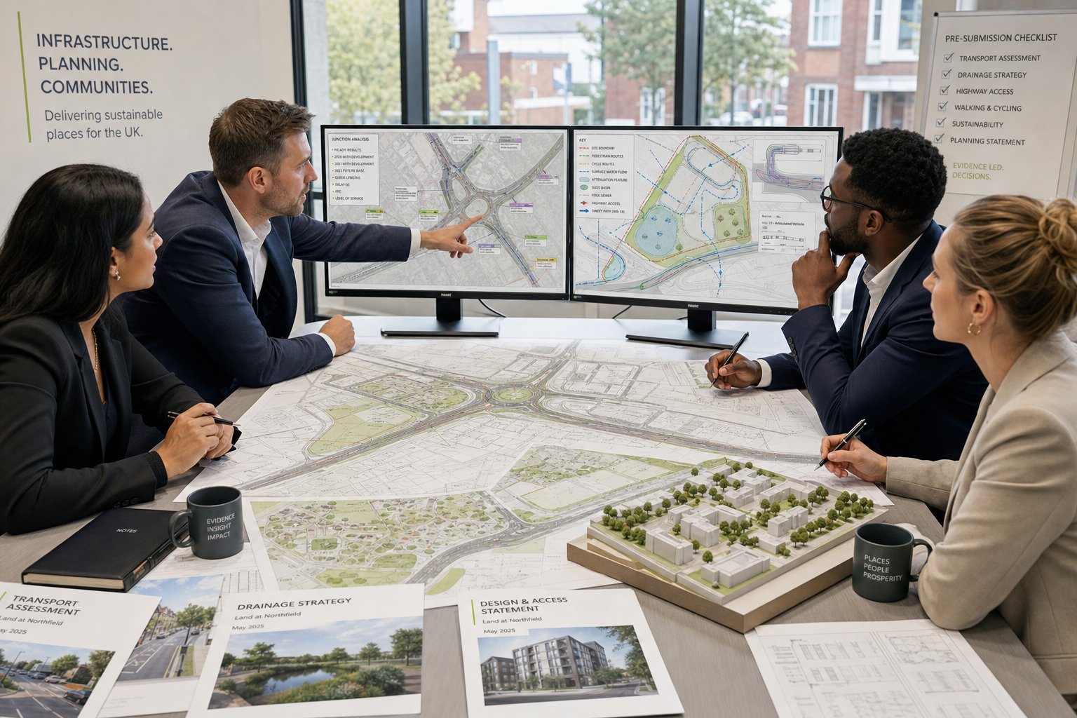
Highway Layouts, Tracking, And Access Appraisals
Highway layouts, swept-path tracking and access appraisals give authorities the practical confidence that a development can function on the ground. These documents often look deceptively simple, but they are where broad intentions meet measurable geometry.
Layouts show carriageway widths, junction form, visibility splays, footways, cycle provision, parking and servicing space. Tracking tests whether refuse vehicles, fire appliances, articulated lorries or other relevant vehicles can manoeuvre safely without unacceptable overrun or conflict. Access appraisals examine how the proposed entrance relates to speed environment, frontage conditions, existing junctions and local highway standards.
For constrained sites, these drawings can be the hinge point of the whole application. If emergency access works only by compromising parking, or if service vehicles clip pedestrian areas, the design may need restructuring. Better to discover that before submission than in a consultation response.
This is also where concise reporting helps. Local authorities and clients alike value drawings and notes that answer the obvious operational questions quickly, accurately and in line with local policy expectations.
Common Infrastructure Challenges For Developers And How To Manage Them
Most development teams meet the same families of infrastructure problems again and again. The details vary by site, but the pattern is familiar: there is not quite enough room, not quite enough capacity, or not quite enough certainty. The way those issues are managed often determines whether a scheme remains commercially and politically viable.
Unsafe or restricted access is one of the most common problems. Existing frontages may be narrow, visibility may be compromised, or the surrounding highway network may already be sensitive. The answer is rarely to force the original concept through unchanged. Better options usually come from testing alternatives early: revised access positions, different unit mixes, one-way operation, shared surfaces where appropriate, or targeted off-site works agreed in principle with the authority.
Flooding and poor drainage are equally persistent. Low spots, high groundwater, constrained outfalls and historic drainage records can all unsettle a project. A realistic levels strategy, SuDS-led design and early dialogue with the LLFA or water company reduce the chance of a late technical objection. And if infiltration is unlikely, it is better to know that before the landscape design promises something impossible.
Utility capacity and diversions are another budget trap. Existing apparatus can sterilise land: new load demands can trigger expensive reinforcements. Capacity checks, corridor planning, provider engagement and a costed view of diversion risk should be part of early due diligence, not a post-permission surprise.
Then there is spatial competition. Roads, parking, trees, attenuation, easements, bin stores, substations and public realm all want the same square metres. This is where iterative multidisciplinary coordination matters most. We need planners, architects, transport engineers, drainage engineers and delivery teams to challenge each other early enough that compromises are strategic rather than desperate.
The developers who manage infrastructure well are usually the ones who accept one truth early: technical constraints are not an interruption to the design process. They are the design process.
Conclusion
Infrastructure engineering for developers is, at heart, a deliverability discipline. It tells us whether a proposal can connect, drain, move, operate and withstand scrutiny before too much cost and confidence are tied up in the wrong layout.
In property development, that matters more than ever. Planning authorities want clearer evidence. Delivery teams need fewer surprises. Investors want risk understood earlier, not explained later. When highways, drainage, utilities and movement planning are coordinated from the start, schemes tend to move with less friction and stronger technical credibility.
The practical takeaway is simple: bring infrastructure thinking in early, scope the right evidence, and treat technical coordination as a value-creation exercise rather than a compliance chore. Done properly, it protects programme, supports planning, improves buildability and leaves behind places that function better long after consent is granted.
That is the real benefit of good infrastructure work. It does not just help developments get approved. It helps them work.
Frequently Asked Questions About Infrastructure Engineering for Developers
What is infrastructure engineering in property development?
Infrastructure engineering involves planning, designing, and delivering the physical networks—such as roads, drainage, utilities, and parking—that make a development site safe, serviceable, and viable for construction and use.
Why is early infrastructure engineering input crucial for developers?
Early involvement helps identify site constraints like access, flooding, or utility capacity before major decisions, reducing redesigns, planning objections, unexpected costs, and delays during development.
Which core infrastructure areas do developers need to coordinate?
Developers must coordinate highways and site access, drainage and utilities, and transport, movement, and servicing strategies to ensure a coherent, compliant, and functional development.
How does infrastructure engineering support successful planning applications?
It provides the technical evidence—such as vehicle tracking, drainage strategies, and utility plans—that planning and highway authorities need to confidently approve proposals as safe and policy-compliant.
What are some common infrastructure challenges developers face, and how can they be managed?
Challenges include unsafe access, poor drainage, utility capacity limits, and competing space demands. Early liaison with authorities, robust SuDS design, capacity checks, and multidisciplinary coordination can effectively address these issues.
What key reports and assessments are essential in infrastructure engineering for planning purposes?
Essential documents include transport assessments with trip generation and mitigation, drainage strategies focusing on SuDS and flood risk, highway layouts with swept paths, and relevant ground and utility surveys, all tailored to planning requirements.