Getting a planning application over the line in Greater Manchester rarely comes down to architecture alone. But strong the design, a scheme can stall if the access is awkward, the junction works don’t stack up, the parking is impractical, or the local highway authority isn’t convinced the proposal can operate safely. That’s where Manchester highway engineering becomes central rather than incidental.
In practice, highway engineering for planning applications is the technical bridge between a development concept and something the network can actually support. We use it to test feasibility early, identify risks before they become objections, and shape evidence that planners, architects, developers and councils can rely on. And in 2026, with tighter scrutiny on active travel, servicing, drainage coordination and deliverability, that early technical input matters more than ever.
Across Manchester and the wider city-region, no two sites behave the same way. A town-centre mixed-use plot near Metrolink raises different issues from an edge-of-settlement residential scheme, a logistics yard, or a school extension on a constrained frontage. The planning process reflects that reality. Highway comments are often highly local, tied to existing traffic conditions, safety records, public transport accessibility, and the standards of the relevant authority.
In this guide, we set out what Manchester highway engineering usually covers, when it’s needed, where schemes often run into trouble, and how to prepare the right information early enough to avoid delay.
What Manchester Highway Engineering Covers In The Planning Process
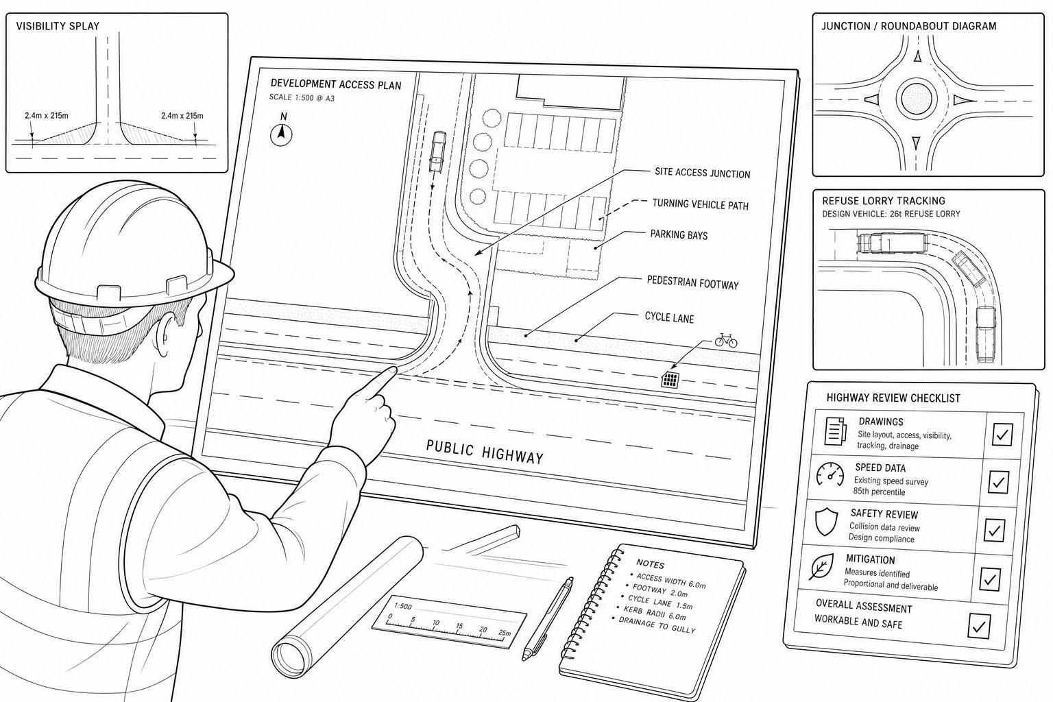
Manchester highway engineering within planning is broader than many teams first expect. It usually starts with feasibility: can the site be accessed safely, can vehicles turn and service it properly, and can the surrounding network absorb the proposal without unacceptable effects? From there, it extends into detailed matters such as junction form, visibility, gradients, parking layout, refuse tracking, pedestrian routes, cycle provision, drainage interfaces and off-site works.
At outline stage, we’re often testing whether a scheme is fundamentally workable. At full application stage, the expectation is higher. Authorities typically want evidence that the access strategy is not just possible in theory but practical in engineering terms and consistent with policy. That may include drawings, capacity assessments, speed data, accident review, servicing plans and a clear explanation of any mitigation.
This is also where highway engineering overlaps with transport planning. A transport assessment might quantify trip generation and network effects, while the engineering side demonstrates that the physical arrangement on the ground can operate safely. Used together, they make a planning submission far more robust.
For development teams needing locally focused input, specialist support from a Traffic Engineer In Manchester: context is often most valuable when brought in before the layout is fixed, not after objections arrive.
Why Local Highway Context Matters Across Greater Manchester
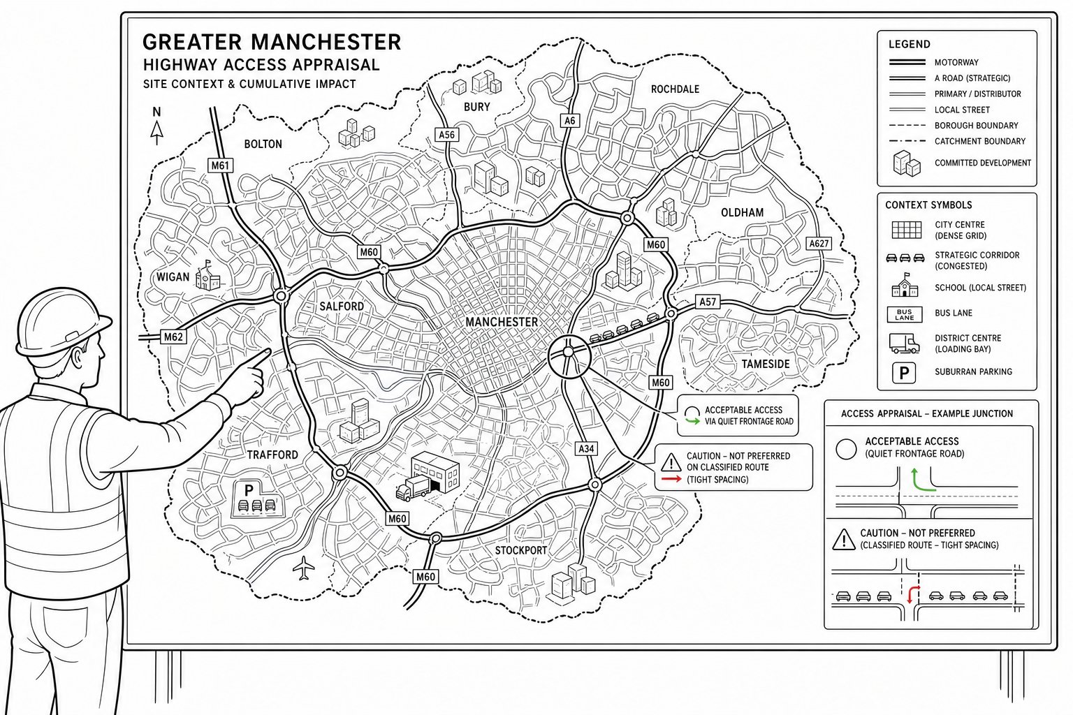
Greater Manchester is not a single highway environment. Manchester city centre, Trafford, Salford, Stockport, Rochdale, Wigan and the other boroughs all have different street patterns, network pressures and local expectations. Some sites sit close to strategic corridors with heavy peak congestion. Others are shaped by school traffic, constrained residential streets, bus priority measures, or existing safety concerns that make even a modest intensification more sensitive.
That local context changes the advice. A new access that may be acceptable on a lower-speed frontage road can be problematic on a classified route with tight junction spacing. Parking demand will be considered differently in a highly accessible urban location than in a suburban area with limited alternatives to the car. In district centres, servicing can be the real issue rather than traffic generation.
We also need to think about committed development and future demand, not just today’s conditions. Highway authorities increasingly look at cumulative impact, especially where several schemes are coming forward in the same catchment.
The result is simple: generic reporting rarely performs well. Site-specific assessment does. The same principle sits behind wider highway infrastructure design, where local standards, existing constraints and delivery realities shape what is actually supportable in planning terms.
Common Development Types That Trigger Highway Engineering Input
Not every planning application needs a full package of highway evidence, but many do. The obvious triggers are major residential schemes, commercial developments, industrial units, care facilities, schools, student accommodation and mixed-use proposals. These tend to create enough movement, servicing demand or layout complexity to justify technical review.
But smaller schemes can trigger highway engineering input too. A single new access onto a busy road, an HMO intensification, a convenience store on a local junction, a drive-thru, or a redevelopment with reduced manoeuvring space can all raise planning concerns. Change-of-use applications are a common example: the building may already exist, but the transport and highway consequences can be materially different.
Extensions and phased schemes also deserve attention. If a site has a lawful baseline but the proposal alters access geometry, servicing patterns, parking demand or pedestrian movement, highway review is often needed.
In practice, we advise developers not to judge the need for engineering input by scheme size alone. The better question is whether the proposal changes how people and vehicles interact with the local road network. If it does, Manchester highway engineering is likely to become part of the planning conversation.
Transport Assessments, Transport Statements, And Highway Engineering Reports
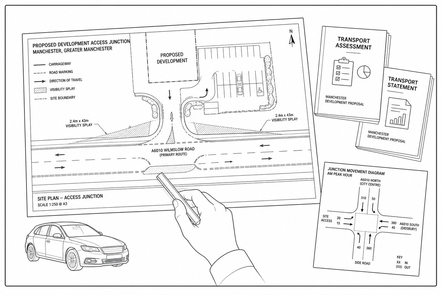
These documents are related, but they do different jobs.
A Transport Assessment (TA) is typically used for larger or more complex developments where a fuller appraisal of travel demand, highway impact and mitigation is needed. It may cover existing conditions, accessibility, trip generation, distribution, assignment, junction modelling, sustainable travel measures and residual effects.
A Transport Statement (TS) is usually more proportionate for smaller schemes where the expected impacts are limited but still need to be evidenced. It tends to be shorter and more focused, but it still needs to deal properly with access, parking, servicing and local network considerations.
A Highway Engineering Report concentrates more directly on the physical and operational acceptability of the proposal: access design, visibility, tracking, internal circulation, levels, drainage tie-ins and any off-site works. Sometimes those matters sit within the TA or TS. Sometimes they are best issued as a separate technical note or drawing package.
The strongest planning submissions usually coordinate all three strands rather than treating them as separate silos. That’s especially true where site layout is evolving alongside planning. Comparable technical approaches used by a Traffic Engineer In Liverpool: or another regional specialist show the same thing: proportionate evidence wins, but only if it is complete, clear and genuinely site-led.
Junction Capacity, Access Design, And Highway Safety Considerations
This is often the section of a planning submission that decides whether highways officers are reassured or unconvinced. Even when trip rates are modest, the authority still needs confidence that vehicles can enter and leave safely, that the junction form is suitable, and that the proposal won’t create avoidable conflict for drivers, pedestrians or cyclists.
Junction capacity testing may be needed where a development adds turning movements to an existing priority junction, roundabout or signalised node. The level of testing depends on the scale of impact, but the principle is straightforward: we need to show whether queues, delay and operational stress remain acceptable, and if not, what mitigation is realistic.
Access design goes beyond drawing a bellmouth. Width, radii, gradients, proximity to nearby junctions, pedestrian crossing points, refuse strategy and emergency access all matter. Safety review should also consider collision history, frontage activity, school routes, on-street parking pressure and likely driver behaviour.
Highway authorities are rarely persuaded by broad assurances alone. They want dimensions, evidence and engineering logic. Cross-sector experience, including work by highway design consultants, reinforces the same lesson: safe access has to be demonstrated, not simply asserted.
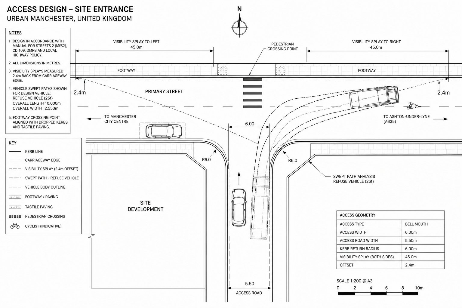
Visibility Splays, Vehicle Tracking, And Swept Path Analysis
Visibility splays remain one of the most common pressure points in planning review. If drivers emerging from a site cannot see approaching vehicles, cyclists or pedestrians clearly enough for the speed environment, objections are predictable. On constrained urban frontages, the issue is often not whether a standard can be drawn on paper, but whether land control, boundary treatments and parked cars allow that visibility to be maintained in reality.
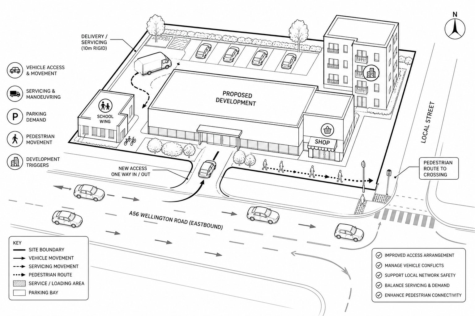
Vehicle tracking and swept path analysis answer a different but equally practical question: can the vehicles that need to use the site actually manoeuvre through it? Refuse vehicles, delivery vans, rigid HGVs and fire appliances all have different requirements. If a larger vehicle has to overrun footways, reverse excessively, or block parking aisles just to function, the layout is unlikely to survive detailed scrutiny.
Parking Layouts, Servicing, And Internal Site Circulation
Parking is not just about hitting a number. Planning officers and highway engineers will look at whether the spaces are useable, whether disabled bays are positioned sensibly, whether cycle parking is secure and convenient, and whether the arrangement creates conflict with servicing or pedestrian routes.
Internal circulation is where many otherwise promising layouts start to wobble. Tight aisle widths, awkward turning heads, bin stores placed across manoeuvring space, or basement ramps that clash with arrivals can all signal that the design has been pushed too far. The same is true for courier activity and short-stay parking, which are increasingly relevant in residential and mixed-use schemes.
Servicing needs similar realism. A site may technically accommodate a delivery vehicle, but if every arrival requires shunting, reversing onto the highway, or managing around parked cars, authorities will question day-to-day operation. Schools, retail units, care facilities and apartment blocks all have distinct servicing patterns, and planning evidence should reflect that.
We’ve found that parking and servicing work best when they are resolved alongside the architecture, not bolted on afterward. Once the internal geometry works, the planning story becomes much easier to defend.
Pedestrian, Cycling, And Public Transport Requirements
By 2026, it is no longer enough for a planning submission to show that cars can get in and out. Authorities across Greater Manchester expect schemes to support sustainable travel in a practical way. That means safe walking routes, coherent cycle access, links to nearby bus or rail services, and layouts that don’t treat active travel as an afterthought.
For pedestrians, the basics still matter most: direct routes, dropped crossings, footway continuity, lighting, overlooked access points and sensible connections between entrances, parking and the street. For cycling, the detail matters just as much as the headline provision. Stands hidden behind service yards or requiring awkward wheeling through buildings are rarely seen as meaningful provision.
Public transport accessibility also feeds into wider judgments about parking demand and trip distribution. A highly connected site may justify a different balance than a poorly served one, but only where that accessibility is genuine, walkable and likely to be used.
This area is one reason local knowledge is so valuable. Multi-modal expectations in central Manchester can differ sharply from outer-borough locations, and the planning narrative needs to reflect that nuance rather than relying on generic sustainability wording.
Drainage, Levels, And Highway Adoption Constraints
Some of the most serious planning and delivery issues are hidden in the engineering detail. A site may appear to have an acceptable access strategy, but if the levels don’t work, the drainage falls are impractical, or the off-site highway tie-in cannot be delivered to adoptable standards, the proposal may still run into trouble.
Drainage is a frequent example. Highway works can’t simply direct runoff into the wrong part of the network or create maintenance issues at the boundary. Surface water strategy, carriageway crossfall, private-versus-public drainage responsibility and SuDS integration all need to be coordinated early. If they aren’t, a layout that looked fine at concept stage can become expensive or unworkable.
Levels matter just as much. Steep approaches, abrupt transitions, inaccessible footways or basement interfaces can affect both highway safety and usability. And where new roads or alterations may be offered for adoption, the authority will usually expect compliance with its technical requirements from the outset.
That is why detailed coordination between planning, drainage and civil design is so important. Similar delivery issues arise well beyond Greater Manchester, and a Traffic Engineer In Birmingham: dealing with another authority would recognise the pattern immediately: unresolved engineering constraints nearly always come back later, usually at the worst moment.
Working With Manchester Councils And Highway Authorities
In Greater Manchester, planning applications are normally reviewed by the local planning authority with input from the relevant highway authority. Depending on the site and network, that can involve district-level planning officers, highways teams, and sometimes wider stakeholders where bus priority, strategic roads or public realm interfaces are affected.
What matters most is understanding how officers will read the submission. They want clear drawings, proportionate evidence, and enough technical explanation to trust that the proposal has been tested properly. They do not want to piece together access logic from fragmented plans, contradictory documents or late clarifications.
Pre-application engagement can be valuable where the site is constrained, politically sensitive or likely to trigger technical concern. It helps flush out issues around access form, junction testing, parking expectations, active travel and off-site works before the full application is lodged. That doesn’t guarantee support, of course, but it can prevent avoidable surprises.
We’ve also found that authorities respond best when the team is candid about constraints. If visibility is tight or servicing is challenging, it is usually better to explain the engineering judgment, tested options and mitigation than to pretend the issue does not exist.
How Highway Engineering Supports A Stronger Planning Submission
Done properly, highway engineering strengthens a planning application in three ways.
First, it improves the scheme itself. Early testing often leads to better access geometry, cleaner internal circulation, more efficient servicing and fewer late-stage design compromises. That has value well beyond planning.
Second, it reduces uncertainty. A submission backed by sound highway evidence gives planners and consultees less room to worry about hidden operational problems. Where concerns do exist, the evidence provides a basis for targeted mitigation rather than broad objection.
Third, it helps align the consultant team. Architects, planners, drainage engineers and clients make better decisions when the highway implications are understood early. That coordination is especially useful on constrained urban sites, where a small shift in levels or frontage design can affect access, visibility, refuse collection and active travel provision all at once.
In short, Manchester highway engineering is not just a compliance exercise. It is one of the practical disciplines that turns a planning concept into a scheme with a credible route to permission and delivery.
Common Reasons Planning Applications Face Highway Objections
Most highway objections are not mysterious. They tend to arise from a familiar set of weaknesses.
Unsafe or poorly justified access is high on the list. That includes inadequate visibility, substandard geometry, conflict with nearby junctions, and layouts that push reversing or awkward manoeuvres onto the public highway. Congestion concerns are another common issue, especially where a proposal adds turning movements at already stressed junctions without convincing evidence or mitigation.
Parking and servicing are frequent pressure points too. Authorities may object where parking provision is either insufficient for the location or physically impractical, where deliveries cannot be accommodated safely, or where refuse collection relies on unrealistic manoeuvres. Weak pedestrian and cycle connections increasingly attract criticism, particularly on schemes that claim sustainability benefits without delivering usable active travel infrastructure.
Then there’s the quieter problem: inconsistency. If the plans, transport report, swept path drawings and drainage strategy do not align, confidence drops quickly. Officers often take that as a sign the scheme has not been resolved.
Many objections are avoidable. But only if the technical work is started early enough for the design to change when needed.
How To Prepare Highway Information Early And Avoid Delays
The best time to tackle highway issues is before the layout hardens and long before validation. In practical terms, that means reviewing the frontage, surrounding junctions, parking demand, servicing strategy, active travel links, drainage constraints and likely authority expectations at concept stage.
We usually recommend a simple sequence. First, test feasibility on the ground: site visit, geometry review, local constraints and policy context. Second, decide what level of reporting is proportionate, perhaps a short note, perhaps a full TA with engineering drawings. Third, coordinate the highway strategy with the architect, drainage engineer and planning consultant so the submission tells one coherent story.
It also helps to be realistic about lead-in times. Speed surveys, junction modelling, topographical information, tracking and design iterations all take time, particularly if comments come back from the authority or the project team changes the layout midstream. Leaving this work until just before submission is one of the quickest ways to create delay.
For developers, planners and design teams, the payoff is straightforward: better evidence, fewer surprises, and a planning application that reads like a resolved proposal rather than a collection of unanswered questions.
Manchester highway engineering is at its most effective when it is used early, proportionately and in step with the rest of the design process. That is usually the difference between a scheme that moves through planning with confidence and one that gets stuck explaining problems that could have been addressed months earlier.
Manchester Highway Engineering FAQs
What does Manchester highway engineering cover in the planning process?
Manchester highway engineering assesses how a development affects local roads, including access, junction capacity, parking, servicing, and safety. It also covers drainage, pedestrian and cycle routes, and ensures proposals comply with local highway policies across Greater Manchester.
Why is local context important in Greater Manchester highway engineering?
Local context matters because each borough, from Manchester city centre to Stockport or Wigan, has unique traffic patterns, congestion issues, and safety records. Tailoring highway engineering to local road conditions and future traffic demand ensures proposals are practical and meet council expectations.
When is highway engineering input required for development proposals in Manchester?
Highway engineering is usually needed for major residential, commercial, or mixed-use schemes, new access points, and applications that change traffic movements or parking. Even smaller changes like HMO intensifications or retail extensions may require assessment if they affect local road networks.
How do Transport Assessments and Highway Engineering Reports differ and work together?
Transport Assessments evaluate trip generation and network impacts for larger developments, while Highway Engineering Reports focus on physical access design, visibility, and manoeuvrability. Together, they provide comprehensive evidence supporting safe and feasible highway arrangements for planning submissions.
What common highway issues cause planning objections in Manchester?
Objections often stem from unsafe or poorly justified access with inadequate visibility, congestion at sensitive junctions, insufficient or impractical parking, problematic servicing arrangements, and weak provisions for pedestrians and cyclists, especially where active travel expects improvement.
How can early highway engineering involvement avoid planning delays?
Engaging highway engineers early enables feasibility testing, coordination with architects and drainage engineers, and preparation of clear, site-specific evidence. This reduces surprises, addresses constraints upfront, and results in coherent submissions that local authorities can assess efficiently.