London development transport advice has become much more than a planning add-on. In 2026, it often shapes whether a scheme is workable at all.
For architects, planners, developers, surveyors, lawyers and local authorities, transport evidence now sits right at the centre of application strategy. A promising site can quickly become constrained by access geometry, servicing conflicts, Healthy Streets expectations, car-free policy, junction sensitivity, or pressure on already stretched kerbside space. And in London, where Transport for London (TfL) and boroughs scrutinise movement impacts closely, weak transport work tends to show up early.
We see this in practice across residential, mixed-use, commercial and urban infill schemes: the transport position influences layout, quantum, frontage design, basement access, refuse arrangements, cycle storage, delivery operations and even viability. Get it right early and the planning pathway is usually smoother. Leave it late and teams can end up redesigning a scheme under pressure, dealing with avoidable objections, or accepting conditions that delay implementation.
This guide explains what London development transport advice covers, when a Transport Statement, Transport Assessment or Travel Plan is likely to be needed, how policy affects scope, and which technical issues typically decide whether an application feels robust to decision-makers. The aim is practical: clearer scoping, better evidence, and fewer planning surprises.
What Development Transport Advice Covers In London
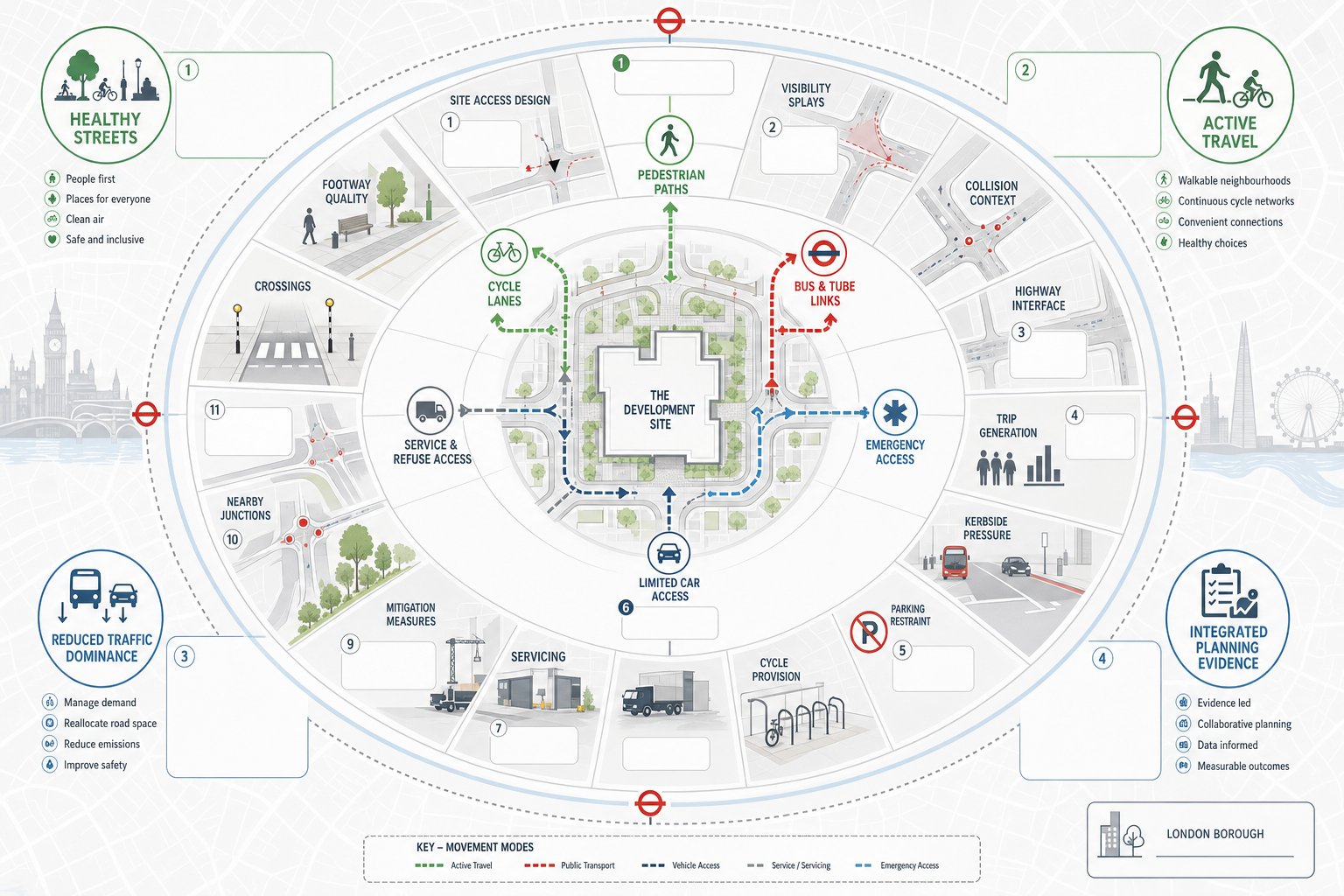
Development transport advice in London covers the full movement picture of a scheme, not just traffic impact in the old-fashioned sense. We are usually testing whether a proposal is safe, accessible, policy-compliant and operationally realistic for people arriving on foot, by cycle, by public transport, by service vehicle and, where relevant, by car.
That means looking at site access design, visibility, highway interface, trip generation, trip distribution, parking restraint, cycle provision, servicing, refuse collection, emergency access, construction logistics and mitigation. It also means understanding how the development sits within its surrounding network: nearby junctions, bus stops, rail or Tube access, footway quality, crossing opportunities, cycle routes, collision history and kerbside pressures.
In London, policy expectations are wider than vehicle capacity. Boroughs and TfL increasingly want evidence that schemes support active travel, reduce traffic dominance and align with Healthy Streets principles. For some sites, especially in dense urban centres, the bigger question is not “can cars get in and out?” but “does the design genuinely prioritise sustainable movement?”
That broader perspective is why planning teams often benefit from involving a Traffic Engineer In London: early. With the right scope, the transport work can guide layout decisions rather than simply reacting to them at the end. In practice, good London development transport advice ties policy, design and evidence together so the application reads as one coherent planning story.
Why Early Transport Input Matters For Planning Success
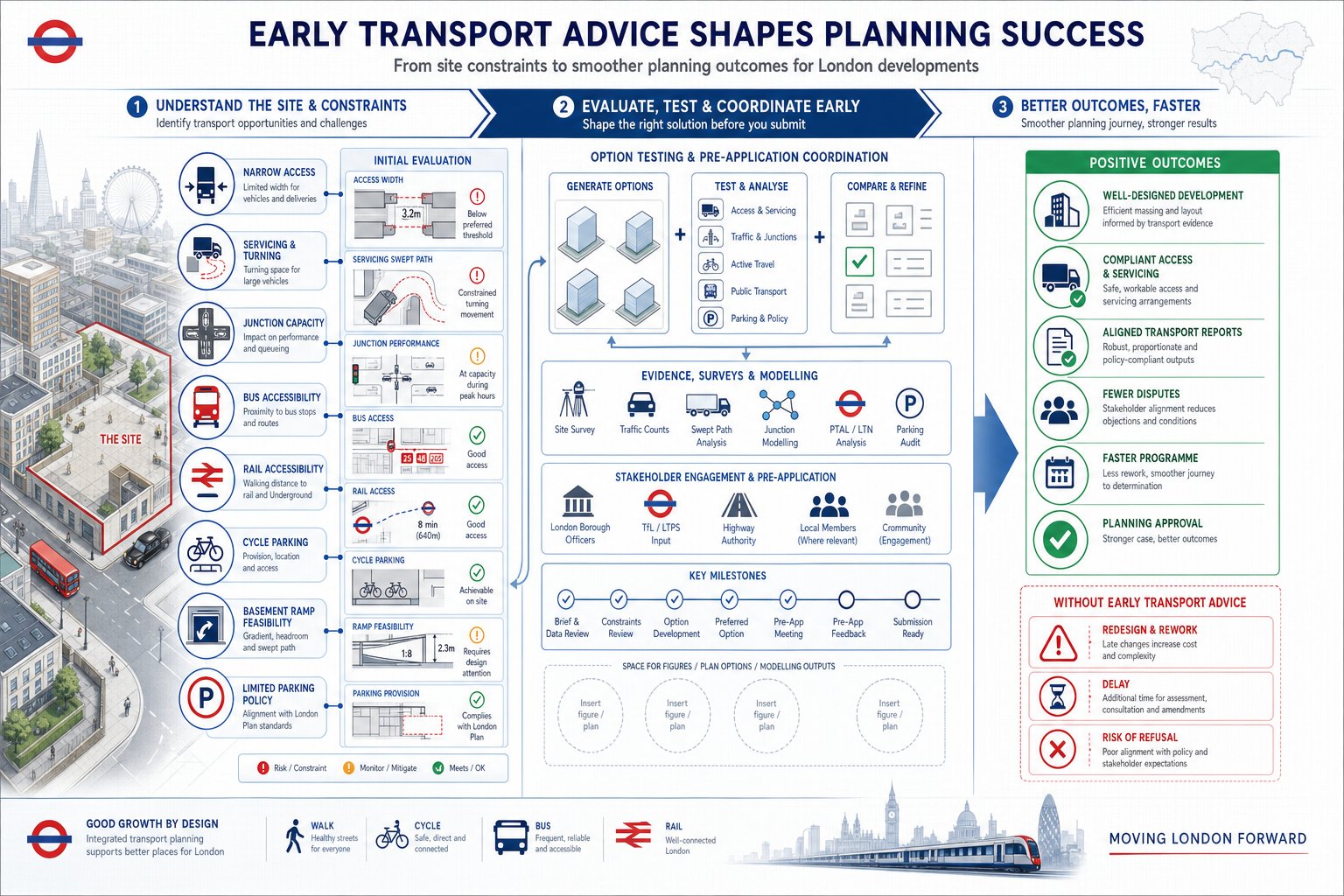
Early transport input matters because transport constraints often fix the realistic development envelope long before the planning statement is drafted. A narrow access, a difficult servicing arrangement, low junction reserve capacity, poor public transport accessibility, or a strict borough parking stance can all limit what is likely to be supported.
When transport advice starts early, we can test those constraints while options are still flexible. That might mean checking whether refuse can turn on-site, whether a basement ramp is feasible, whether cycle parking can fit without compromising active frontage, or whether a larger quantum would trigger a more demanding assessment threshold. These are not minor technical details. They frequently influence value, design efficiency and programme.
Early work also helps with pre-application strategy. TfL and local planning authorities are far more receptive when the scope is sensible, transparent and proportionate. Agreeing survey needs, modelling assumptions and reporting expectations up front reduces the risk of post-submission disputes. It can also prevent a common problem: a transport report that answers the wrong question.
For planning teams dealing with complex schemes, the discipline behind a robust transport assessment for applications often begins months before submission. The same is true for strategic Property Development Transport input, where the transport case needs to support the wider planning narrative from the outset.
Put simply: early transport advice is cheaper than redesign, faster than arguing after submission, and usually far less painful than a refusal rooted in issues everyone could have seen coming.
How London Planning Policy Shapes Transport Requirements
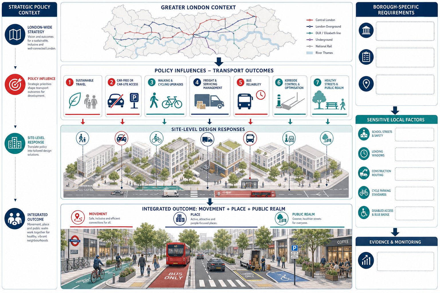
London planning policy has a direct effect on transport scope, mitigation and design quality. The London Plan continues to push strongly toward sustainable travel, car-free or car-lite development in accessible locations, better walking and cycling environments, freight management and public realm improvements that support Healthy Streets outcomes.
So the transport question is rarely just whether impacts are “severe” in highway terms. Boroughs and TfL may also ask whether the scheme minimises private car dependence, supports mode shift, integrates with local cycle networks, protects bus reliability, manages servicing efficiently and uses kerbside space responsibly. A technically workable access arrangement can still face resistance if it cuts across wider policy aims.
Local policy then adds another layer. Borough Local Plans, transport strategies, parking standards and supplementary guidance often sharpen the position on matters such as disabled parking provision, cycle design, loading hours, school street sensitivity, consolidation, public realm quality or construction routing. In the City, inner London and central activity areas, those requirements can be exacting.
This is where policy-led scoping becomes important. A strong report will not treat transport as a generic national exercise: it will respond to the borough and site context. That is one reason many teams are moving toward vision led transport approaches, where movement, place and public realm are considered together. For larger, more layered proposals, a mixed use masterplan strategy can help align transport evidence with urban design rather than leaving those discussions to conflict later in the process.
When A Transport Statement, Transport Assessment, Or Travel Plan Is Needed
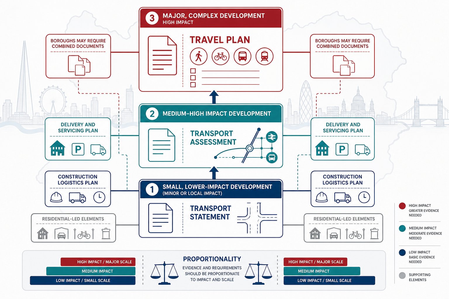
The right transport document depends on scale, use, location and likely impact.
A Transport Statement (TS) is generally used for smaller or lower-impact development where the transport effects are expected to be limited and can be addressed through proportionate evidence. It still needs to be credible, but the level of testing is lighter.
A Transport Assessment (TA) is usually required where the proposal is larger, more complex, or likely to create noticeable effects on the local highway, public transport or active travel environment. That can include residential schemes above local thresholds, mixed-use developments, schools, logistics uses, healthcare schemes or sites with difficult access conditions.
A Travel Plan is commonly required for major development and for uses that generate substantial person trips. Its role is not decorative. A good Travel Plan sets realistic measures, targets, management arrangements and monitoring to encourage sustainable mode share over time.
In London, boroughs may ask for a TS, TA and Travel Plan in combination, sometimes alongside a Delivery and Servicing Plan or Construction Logistics Plan. For residential-led proposals, a focused Residential Development Transport approach can be especially useful because trip patterns, parking stress, cycle provision and servicing often need to be addressed together.
The key is proportionality: enough evidence to satisfy policy and decision-makers, without overcomplicating straightforward schemes.
How Local Authority Thresholds And Site Context Affect Scope

Thresholds are important, but they are only the starting point. London boroughs often set indicative triggers by land use, floorspace, dwelling numbers or expected trips, yet the actual scope can expand or contract depending on local conditions.
A site close to a congested junction, bus corridor, school, hospital, strategic cycle route or sensitive residential street may require more detailed testing even if the scheme is not especially large. Equally, a modest central London development with excellent public transport and a clear car-free offer may need careful work on servicing and kerbside demand rather than extensive highway modelling.
PTAL, controlled parking zones, conservation constraints, existing footway widths, collision records, nearby cumulative developments and the role of the road in the network all matter. TfL involvement can also change the level of detail required, particularly if the site affects the Transport for London Road Network or strategic bus operations.
That is why we never advise relying on generic assumptions. The best approach is to agree scope early with the relevant authority and tailor the technical package to the actual planning risk. A report that is too light can invite objection. One that is too broad can waste programme and budget without improving the decision.
Key Transport Issues That Need To Be Tested For A Development
Most London applications need to show that the proposal works operationally, safely and in policy terms. The exact tests vary, but the recurring issues are fairly consistent.
We usually start with baseline conditions: existing traffic flows, walking and cycling demand, public transport accessibility, local collision patterns, parking stress, servicing activity and kerbside occupation. From there, we assess likely person trips and vehicle trips, identify where those trips will go, and decide whether the surrounding network or streetscape needs more detailed analysis.
Depending on the scheme, testing may include junction capacity, queueing, access visibility, swept paths, pedestrian comfort, cycle conflict, bus stop accessibility, public transport crowding, parking accumulation, delivery frequency, refuse collection movements, construction effects and cumulative impact with nearby committed developments.
What matters most is relevance. A weak report often throws data at the reader without explaining the planning consequence. A strong one connects evidence to decision-making: this access is safe: this servicing arrangement avoids reversing on street: this level of cycle parking complies: this demand can be absorbed: this mitigation is proportionate.
That practical thread is what turns technical analysis into planning support rather than just paperwork.
Access, Servicing, Refuse Collection, And Emergency Vehicle Strategy
Access strategy is one of the first issues authorities test, because if vehicles cannot enter, turn, wait and leave safely, the rest of the application quickly unravels.
For many London sites, the challenge is not only geometric feasibility but also street conditions: narrow carriageways, timed restrictions, pedestrian volumes, bus lanes, trees, basement ramps, floating cycle tracks or busy kerbside activity. We need to show that servicing and refuse can happen without unsafe manoeuvres, prolonged obstruction or conflict with vulnerable road users.
Swept-path analysis is usually central here. Refuse freighters, delivery vans, fire appliances and moving vehicles each have different spatial requirements, and assumptions need to match the actual operator or likely fleet. On-site servicing is typically preferred where feasible, but constrained urban plots sometimes require carefully managed on-street arrangements with booking systems, timing controls or loading management.
Emergency access also needs to be thought through early, especially on tight infill sites and taller buildings. Fire service access distances, turning needs and unobstructed routes should be coordinated with the architect and fire consultant, not retrofitted later.
In our experience, access and servicing problems are among the most common causes of late redesign because they expose tensions between architecture, operations and highway reality all at once.
Active Travel, Public Transport, And Healthy Streets Considerations
London policy expects development to support walking, cycling and public transport first. That sounds obvious, but the real test is whether the scheme makes those choices easier in day-to-day use.
We hence look beyond headline PTAL. Is the walking route to the station direct, legible and step-free? Are crossings convenient or hostile? Does cycle access work for adapted cycles as well as standard ones? Are entrances arranged so pedestrians are not squeezed by vehicle movements? Does the public realm feel safer and less traffic-dominated after the development is built?
Healthy Streets considerations matter here. Boroughs and TfL may expect improvements such as wider footways, better crossings, reduced guardrailing, lower vehicle conflict, improved lighting, clearer wayfinding or street trees where appropriate. For some schemes, the transport case is strengthened not by proving there is no harm, but by showing a net movement and place benefit.
Public transport assessment can also be important. Even where network impacts are modest, authorities may want reassurance on bus stop accessibility, route capacity, interchange quality and first/last-mile conditions. The strongest submissions treat active travel and public transport as core development infrastructure, not as nice extras mentioned at the end.
Parking, Cycle Provision, Delivery Management, And Kerbside Demand
Parking in London is policy-led and heavily context-sensitive. The London Plan sets maximum standards, many boroughs favour car-free or car-lite development in accessible locations, and controlled parking zones often underpin the practical operation of those policies. So the parking strategy must be justified carefully, especially where market expectations differ from policy direction.
That means considering blue badge provision, electric vehicle charging, car club spaces where relevant, and whether permit-free obligations are likely to be required. Overspill risk also needs to be addressed honestly, particularly on borough borders or in streets with mixed controls.
Cycle parking is equally important. Authorities expect secure, convenient and inclusive provision that matches design standards, with sensible access routes and enough space for non-standard cycles. On employment schemes, showers, lockers and end-of-trip facilities may also be needed.
Kerbside demand is often the hidden issue. Even if private parking is low, deliveries, servicing, drop-off activity, ride-hail use and refuse collection all compete for the same limited edge-of-carriageway space. Delivery and Servicing Plans are hence becoming more important, especially in dense centres.
For schemes that interact with wider movement patterns, principles from regional transport planning can help frame how local kerbside decisions connect to broader access and logistics strategy.
Surveys, Modelling, And Technical Evidence Used In London Applications
The quality of a transport submission depends heavily on the evidence underneath it. In London, that usually starts with robust baseline surveys: traffic counts, turning counts, pedestrian and cycle flows, parking beat surveys, servicing observations, bus stop audits and sometimes kerbside occupancy reviews. Collision data, site accessibility mapping and public transport information form part of the baseline too.
Trip generation is then estimated using suitable databases, comparable surveys, census data or local evidence, with professional judgement applied to avoid crude assumptions. Distribution and assignment need to reflect real travel patterns, not just convenient modelling geography.
Where network impact could be material, junction modelling may be required using tools appropriate to the context. For more complex or highly urban sites, we may also use queue analysis, microsimulation or specific assessments of bus, pedestrian or cycle interaction. Parking accumulation, servicing schedules and public transport capacity checks can all play a role.
But technical sophistication is not the point in itself. Decision-makers want evidence that is transparent, proportionate and reproducible. If assumptions are opaque or survey days are poorly chosen, the analysis can lose credibility quickly.
Good transport evidence is rarely the longest report in the room. It is the one that uses the right data, explains the method clearly, and answers the authority’s likely questions before they need to ask them.
Common Planning Risks And How To Avoid Delays Or Objections
The most common planning risks in transport work are surprisingly predictable.
One is underestimating impact. That might mean low trip rates, ignoring peak overlap with local pressure points, or assuming a sensitive junction will cope without testing. Another is policy non-compliance, especially around cycle parking, car-free commitments, servicing or Healthy Streets expectations. A third is operational vagueness: the report says servicing will be “managed”, but gives no workable detail on where, when or by whom.
Construction is another frequent weak spot. Boroughs increasingly expect realistic logistics planning, routing, timing and protection for pedestrians and cyclists. If the site is constrained, a thin construction strategy can trigger justified concern.
The best way to avoid these problems is simple, though not always easy: start early, scope properly, use current data, be candid about constraints and coordinate across the design team. Pre-application engagement with the borough and, where relevant, TfL can save weeks later. So can clear audit trails on assumptions and modelling choices.
We have found that experienced, concise reporting often carries more weight than inflated documentation. That is one reason firms offering London development transport advice tend to focus on authority-specific scope rather than boilerplate. Even lessons from places outside the capital, such as a Birmingham Transport Consultant: approach to planning-led evidence, reinforce the same principle: decision-makers respond best to transport work that is practical, honest and tailored.
Choosing The Right Scope And Programme For Your Application
Choosing the right scope is part technical exercise, part programme management. The goal is to prepare enough evidence to support consent without creating unnecessary rounds of analysis that add little planning value.
We usually begin by asking a few basic questions. What are the likely authority triggers? Is TfL likely to be involved? Which transport issues could genuinely threaten support: access, servicing, parking, junction impact, active travel, construction, kerbside conflict? And which of those issues can influence design now, before the application hardens?
From there, the programme needs to allow for surveys, data processing, design coordination, draft reporting, pre-application discussion and review cycles. Seasonality matters. So does school term, roadworks, network changes and the time authorities need to review technical submissions. If modelling is required, build in time for iteration. It nearly always takes longer than the optimistic version in the first programme.
For straightforward sites, a compact TS and Travel Plan may be enough. For more complex proposals, a TA plus supporting logistics and servicing documents may be the realistic minimum. The key is to match effort to risk.
Done properly, scope is not an administrative step. It is one of the strongest tools we have for reducing planning friction, protecting programme certainty and keeping the transport work aligned with the real issues that will decide the application.
Conclusion
London development transport advice works best when it is brought in early, scoped intelligently and tied closely to policy, design and operational reality. In 2026, that means more than proving a development does not overload a junction. It means showing that the scheme is safe, accessible, deliverable, and aligned with the London Plan, borough expectations, active travel priorities and Healthy Streets principles.
For planning teams, the practical lesson is straightforward: treat transport as a design and strategy input, not a late reporting exercise. The strongest applications are usually the ones where access, servicing, cycle provision, kerbside demand, public transport access and mitigation have been resolved before submission pressure kicks in.
When that happens, the evidence is clearer, objections are easier to manage, and consent is simply more likely to move on a sensible timetable.
London Development Transport Advice FAQs
What does London development transport advice typically cover?
London development transport advice covers site access, trip generation, parking, servicing, active travel, public transport, Healthy Streets, construction impacts, and related mitigation, all aligned with the London Plan and local transport policies to ensure schemes are safe, accessible, and sustainable.
Why is early transport input crucial for planning success in London?
Early transport input helps identify constraints like access or parking restrictions, shaping design and scale before submission. This reduces risks of redesign, refusals, or conditions by aligning with Transport for London and borough policies from the start, making the planning process smoother.
When is a Transport Assessment or Travel Plan required for London developments?
A Transport Statement suffices for small proposals, but larger or impactful developments need a Transport Assessment to evaluate traffic and public transport effects. Major schemes or trip-intensive uses often require a Travel Plan to encourage sustainable travel modes in line with London’s policies.
How do London’s planning policies influence transport requirements for developments?
Polices like the London Plan prioritise car-free or car-lite schemes, active travel, and Healthy Streets outcomes. Borough Local Plans add local rules on parking, cycle storage, and servicing, meaning transport advice must address these to gain planning support.
What key transport issues must be tested in London development applications?
Applications must show operational safety for access, junctions, pedestrian and cycle safety, public transport capacity, parking management, servicing logistics, construction traffic plans, and cumulative impacts with neighbouring developments to meet London’s comprehensive standards.
How is parking and cycle provision managed in London developments?
London enforces maximum car parking limits, often favouring car-free designs in accessible locations, requires electric vehicle charging, and expects secure, inclusive cycle parking with appropriate facilities. Delivery and servicing plans also manage kerbside demand effectively.