A low traffic neighbourhood design can look deceptively simple from the outside: a planter here, a camera restriction there, perhaps a short section of road no longer available for through-movements. But anyone involved in planning, transport, architecture or development knows the reality is much more technical. The difference between a scheme that works and one that causes avoidable objections usually comes down to how well the wider network has been understood.
In 2026, LTNs are no longer a fringe idea or a one-size-fits-all intervention. They sit within broader conversations about active travel, placemaking, road safety, servicing, emergency response and planning policy compliance. For developers and consultants, that means low traffic neighbourhood design is less about isolated traffic calming measures and more about proving that movement, access and network performance have been considered together.
We see this regularly in planning work. Local planning authorities want clear evidence that through-traffic is being managed without undermining access for residents, deliveries, refuse collection or blue-light services. They also want reassurance that problems are not simply being pushed onto the next street.
This guide sets out what low traffic neighbourhood design means in practice, the principles that shape a successful scheme, and the planning considerations that matter when preparing transport evidence. It is written for professionals who need robust, usable answers rather than slogans.
What Low Traffic Neighbourhood Design Means In Practice
In practice, low traffic neighbourhood design is an area-wide movement strategy rather than a single road closure. The aim is to stop general motor traffic from using residential streets as short cuts while preserving access to homes, workplaces, schools, deliveries and emergency services.
That distinction matters. If we only close one street, traffic often diverts to the nearest alternative residential route. A proper LTN design treats the neighbourhood as a connected network and uses filters, turn restrictions, one-way arrangements or camera-controlled access so that drivers can still enter the area, but cannot drive through it end to end unless they have a legitimate reason and a permitted route.
A well-designed LTN remains permeable for walking and cycling. In many schemes, that is the whole point: journeys on foot or by cycle become shorter, safer and more direct than motor vehicle movements. Boundary or distributor roads continue to carry the strategic flow of traffic, while internal streets become calmer and more local in character.
From a planning perspective, this means the design case cannot rely on intent alone. We need to show how the street pattern works, where displaced trips are likely to go, how access is maintained, and whether the change supports the intended land use and policy objectives.
Why LTNs Are Being Used In New And Existing Developments
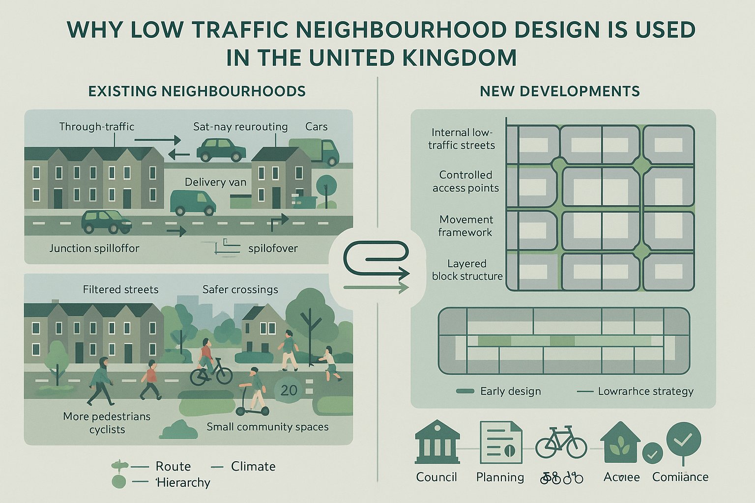
LTNs are being used because many neighbourhoods were never designed to absorb modern levels of through-traffic. Sat-nav routing, rat-running between congested junctions and rising delivery traffic have all increased pressure on streets that primarily serve housing, local services and community facilities.
For existing neighbourhoods, the motivation is usually to reduce cut-through traffic, lower vehicle speeds, improve safety and create a more liveable public realm. Quieter streets tend to support walking, cycling and informal social use more effectively than streets dominated by non-local traffic.
In new developments, LTNs are often embedded earlier as part of the movement framework. That allows masterplanners and transport consultants to shape block structure, access points and route hierarchy from the outset. Rather than retrofitting restrictions later, the neighbourhood can be designed so that strategic traffic naturally stays on appropriate roads.
There is also a policy and commercial driver. Councils increasingly expect schemes to align with active travel, climate and placemaking objectives. Developers want layouts that are policy-compliant, attractive to buyers and less vulnerable to highways objections. In that context, low traffic neighbourhood design becomes a practical tool for achieving both transport and planning outcomes, provided the supporting evidence is sound.
Core Design Principles For A Successful Low Traffic Neighbourhood
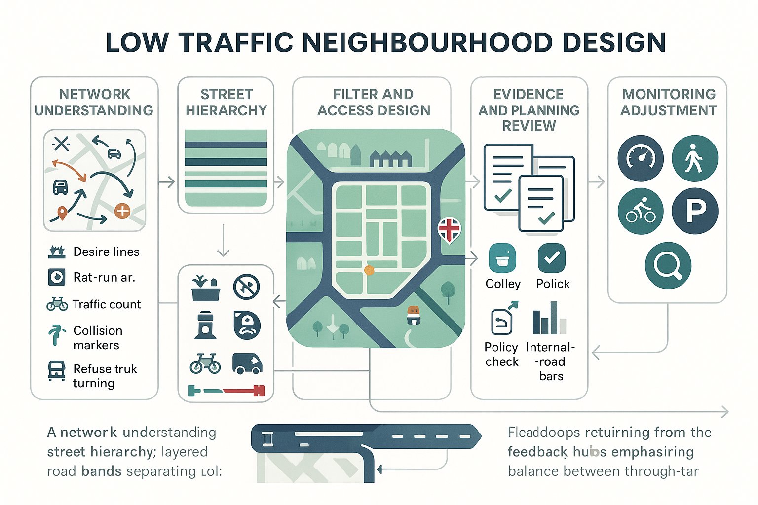
Successful LTNs share a small number of principles, even when the street pattern, scale and policy context differ.
Street Hierarchy, Movement And Access Strategy
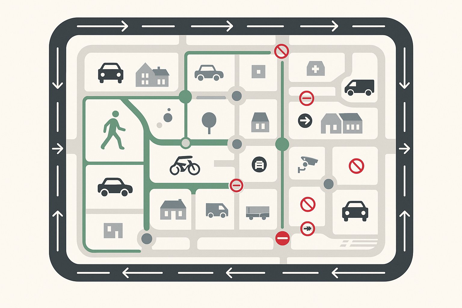
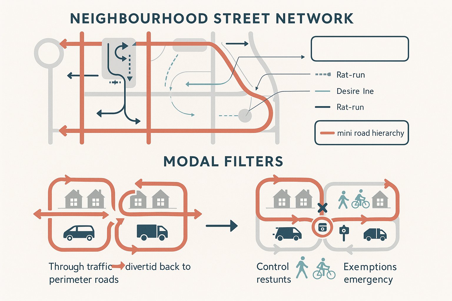
The starting point is a clear street hierarchy. Boundary roads and distributor routes should accommodate through-movement, busier traffic flows and wider network connections. Internal residential streets should primarily serve access, local circulation and short local trips. If those roles are blurred, filtering becomes difficult to justify and even harder to operate cleanly.
We hence need a movement strategy that distinguishes between strategic traffic, local vehicle access, servicing and active travel. That usually means mapping desire lines, identifying rat-run patterns, understanding junction constraints and checking whether nearby roads can realistically absorb reassigned traffic.
A robust hierarchy also helps with planning narratives. It shows that the design is not anti-car in a simplistic sense: it is about putting the right traffic on the right streets.
Filtering Through-Traffic Without Blocking Essential Access
The second principle is straightforward but often mishandled: remove through-traffic, not access. Residents, visitors, carers, deliveries, refuse vehicles and emergency services must still be able to reach properties safely and reliably.
This is where modal filters, exemptions, lockable bollards, camera enforcement and carefully chosen turning arrangements come in. The exact solution depends on geometry, frontage, servicing needs and operational requirements. A filter in the wrong place can add unnecessary mileage, create awkward reversing movements or compromise response times.
So we test more than one option. The best low traffic neighbourhood design usually finds a balance where everyday through-movements are filtered out, but essential access remains legible and workable.
Street Layout, Modal Filters And Public Realm Elements
Street layout does much of the heavy lifting in an LTN. Filters are important, but they only work well when the wider network geometry supports them. A permeable grid may need multiple interventions to stop through-routing, whereas a layout with natural cells or short blocks may need very little.
Modal filters can take several forms: bollards, planters, kerb build-outs, bus gates, rising bollards or camera-enforced restrictions. The choice is rarely aesthetic alone. We look at turning heads, refuse tracking, cycle permeability, maintenance, drainage, visibility and the risk of non-compliance.
Physical design also shapes perception. If the street still reads like a traffic corridor, drivers will continue trying to use it as one. That is why many successful schemes combine filters with tightened junction radii, raised tables, planting, seating, cycle parking and better crossing points. These public realm elements signal that the street’s primary function has changed.
But restraint matters. An LTN should not become cluttered with street furniture or overdesigned features that complicate maintenance and access. In planning and delivery terms, the strongest approach is usually simple, legible and easy to enforce: clear routes for vehicles with legitimate reasons to be there, and generous permeability for everyone else.
Designing For Walking, Cycling, Servicing And Emergency Access
One of the quickest ways to weaken an LTN proposal is to consider active travel first and leave servicing or emergency access until later. In reality, these have to be designed together.
For walking, the priorities are directness, crossing quality, passive surveillance, inclusive footway widths and links to schools, local centres and public transport. For cycling, permeability is key. Cyclists should be able to travel through the area more directly than general traffic, without confusing dismount points or awkward chicanes.
Servicing requires a different layer of detail. We need to understand loading patterns, vehicle sizes, turning requirements, delivery frequency and whether larger vehicles can still enter, stop and exit without conflict. The same applies to refuse collection and maintenance access.
Emergency access is often the point that determines filter design. Fire and rescue services, ambulance trusts and police operators may require lockable bollards, overrun strips, removable sections or alternative entry paths. The answer varies by authority and site context, so early consultation matters.
When these demands are coordinated from the start, low traffic neighbourhood design becomes much easier to defend. The scheme reads as a functioning access network rather than an aspirational sketch with operational problems still hidden in the margins.
How Traffic Data And Transport Assessments Inform LTN Design
Good LTN design is evidence-led. Before recommending filters or restrictions, we need to understand existing traffic conditions, trip patterns and likely reassignment effects. That typically starts with traffic counts, turning counts, speed data, collision records, parking stress observations and site audits.
Origin-destination information is especially useful where cut-through traffic is suspected but disputed. It helps distinguish local access trips from non-local movements using residential streets for convenience. Depending on scale, we may also review journey time data, school travel patterns, bus routing and pedestrian and cycle desire lines.
Transport assessments then translate this evidence into design decisions. They test whether traffic is likely to divert to suitable roads, whether junctions on the boundary network can cope, and whether access arrangements remain practical for the proposed land use. For planning applications, they also explain the rationale in a form local authorities can review against policy and development management thresholds.
At ML Traffic, this is where concise and accurate reporting matters. Councils rarely want theoretical overkill: they want clear analysis tied to local circumstances and planning triggers. A credible assessment should show not just what the LTN is trying to achieve, but how the network is expected to behave once the scheme is in place.
Planning Policy, Local Authority Expectations And Approval Risks
Planning policy support for LTNs is usually indirect but strong. Schemes often align with local plan objectives on sustainable transport, healthy streets, safer neighbourhoods, air quality and placemaking. Nationally, active travel and well-designed places remain important themes, even though implementation approaches vary from one authority to another.
The catch is that policy support does not guarantee approval. Local authorities typically want evidence on three points: network impact, access continuity and deliverability. If any of those are weak, risk rises quickly.
Approval problems often arise where proposals rely on vague future controls, where boundary-road impacts have not been tested, or where emergency and servicing arrangements remain unresolved. Another common issue is mismatch between the planning red line and the transport effects. If a development depends on off-site filtering to function acceptably, the application needs to explain how that will be secured.
Councils also increasingly expect engagement. Local support is not the only test, but ignoring likely user concerns is rarely wise. Objections around displacement, school access, parking pressure or business servicing can become material if the evidence base is thin.
So the safest route is a coordinated package: policy fit, traffic evidence, access strategy, and a realistic delivery mechanism. That combination gives decision-makers confidence that the proposal is practical, not merely aspirational.
Common Low Traffic Neighbourhood Design Mistakes To Avoid
The most common mistake is treating an LTN as a single intervention rather than an area strategy. One filter on one street may solve a local complaint, but it can just as easily push traffic onto the next residential road and create a fresh problem.
A second mistake is weak boundary-road thinking. If the surrounding network is already constrained, traffic reassignment needs careful modelling and honest explanation. Pretending there will be no effect is not credible and usually invites challenge.
Third, teams sometimes design for idealised travel behaviour and forget operational reality. Delivery vans still need somewhere to stop. Refuse vehicles still need turning space. Emergency services still need robust and agreed access arrangements. If those basics are not integrated, objections are justified.
Another recurring issue is poor legibility. Drivers, cyclists and visitors need to understand how the network works. Confusing restrictions, inconsistent signing or awkward one-way arrangements can generate non-compliance and frustration.
And finally, some schemes are advanced without enough monitoring or flexibility built in. Even strong designs may need adjustment after implementation. The authorities that manage LTNs best are usually the ones that accept from day one that refinement is part of delivery, not evidence of failure.
Monitoring, Adjustment And Long-Term Network Performance
An LTN should never be treated as finished on the day the filters go in. Travel behaviour changes over time, nearby development comes forward, schools expand, junctions are altered and delivery demand shifts. Monitoring is what tells us whether the original assumptions are still holding.
Typical monitoring covers traffic volumes within the neighbourhood, flows on boundary roads, speeds, collisions, walking and cycling activity, parking conditions and, where relevant, journey times for key services. Qualitative feedback also matters. Residents, businesses, bus operators and emergency services often spot friction points that raw counts do not immediately reveal.
Adjustment mechanisms should hence be designed in from the outset. That might mean trial filters before permanent works, phased implementation, or a review framework tied to measured outcomes. Sometimes the right response is minor: moving a planter, changing signage, refining an exemption. Sometimes it is more strategic, especially if adjacent streets begin taking displaced traffic unexpectedly.
Long-term network performance is the real test. A successful low traffic neighbourhood design should continue to support access, safety and placemaking without creating hidden costs elsewhere. If monitoring is rigorous, councils and project teams can make informed changes rather than relying on anecdote or political noise alone.
Applying Low Traffic Neighbourhood Design To Planning Applications
For planning applications, low traffic neighbourhood design needs to be translated into a clear and defensible evidence package. Decision-makers are not only asking whether the concept is attractive: they are asking whether it works on the network, whether access is maintained, and whether any required controls can realistically be delivered.
In practice, that means the transport submission should do several things well:
- define the existing and proposed street hierarchy:
- explain the access strategy for residents, visitors, servicing and emergency response:
- identify where through-traffic is expected to be filtered and how active travel remains permeable:
- assess traffic reassignment and boundary-road effects:
- align the proposal with local policy, parking strategy and placemaking objectives.
Where LTNs support a wider development, the narrative should be tied directly to the scheme’s layout, trip generation and land-use assumptions. Plans, swept paths, traffic data and concise commentary need to tell one consistent story.
This is often where specialist reporting adds value. On sites where planning thresholds, local authority expectations and off-site highway impacts are tightly scrutinised, clear transport evidence can make the difference between a manageable consultation process and a stalled application. The design itself matters, obviously. But in development terms, the quality of the supporting case matters just as much.
Conclusion
Low traffic neighbourhood design works best when we stop thinking about it as a quick street closure exercise and start treating it as a network, access and placemaking discipline. The strongest schemes are area-wide, evidence-led and realistic about how people, vehicles and services actually move.
For architects, planners, developers and councils, that means focusing on the fundamentals: a clear street hierarchy, careful filter placement, maintained essential access, robust traffic analysis and a planning strategy that matches local authority expectations. Get those pieces right and an LTN can support quieter streets, safer movement and stronger development outcomes. Get them wrong and the scheme can unravel under perfectly foreseeable objections.
In 2026, the bar is higher than it was a few years ago. Authorities expect better evidence, clearer access strategies and more credible monitoring plans. That is not a problem: it is an opportunity to produce schemes that work in practice as well as on paper.
Low Traffic Neighbourhood Design FAQs
What is a low traffic neighbourhood (LTN) design?
An LTN design creates an area-wide strategy that restricts through-traffic on residential streets using filters and access controls, while maintaining safe, reliable access for residents, deliveries, and emergency services, promoting active travel and calmer streets.
How does low traffic neighbourhood design improve road safety and active travel?
By removing non-local through-traffic and reducing vehicle speeds, LTNs make streets quieter and safer, encouraging walking and cycling through improved permeability and shorter, more direct routes for pedestrians and cyclists.
Why is it important to treat LTNs as area-wide schemes rather than single road closures?
Filtering only one street can simply divert traffic to nearby residential roads, creating new problems. An area-wide design uses a connected network approach to effectively manage traffic flow and prevent displacement onto adjacent streets.
How do LTNs balance filtering through-traffic while maintaining essential access?
LTNs use physical filters like bollards or camera-controlled restrictions that stop through-traffic but allow residents, visitors, servicing vehicles, and emergency responders to access properties safely and conveniently.
What role does traffic data and transport assessment play in designing LTNs?
Traffic counts, origin-destination data, and transport assessments help identify rat-running patterns, test traffic reassignment effects, and ensure boundary roads can absorb diverted traffic without causing new congestion or safety issues.
Can LTNs be adjusted after implementation, and why is monitoring important?
Yes, monitoring traffic volumes, speeds, collisions, and user feedback allows authorities to fine-tune LTNs over time, addressing unforeseen issues and ensuring the scheme continues to support safety, access, and placemaking goals effectively.