A supermarket scheme can look straightforward on a layout plan and still become surprisingly awkward once transport is tested properly. One access point in the wrong place, one set of optimistic trip assumptions, or one missing delivery swept path can be enough to slow an application down for weeks. Sometimes months.
That’s why a supermarket transport assessment matters so much in 2026. For planning teams, it isn’t just a compliance document. It’s the piece of evidence that shows a proposed foodstore, extension or retail-led redevelopment can function safely, efficiently and acceptably within the local network. Done well, it gives planners, highway officers and consultees confidence early. Done badly, it invites questions, rework and avoidable objections.
We see this regularly across supermarket and wider retail submissions: the schemes that move faster are usually the ones where the transport scope is proportionate, the survey data is current, and the conclusions line up with local policy and real site conditions. That sounds obvious, but it’s where many applications still wobble.
In this guide, we break down what a supermarket transport assessment should cover, when it is likely to be needed, how local authority expectations shape the scope, and what typically causes challenges. The aim is simple: help architects, planners, developers, legal teams and councils prepare planning-ready submissions that are technically robust and easier to approve.
What A Supermarket Transport Assessment Covers
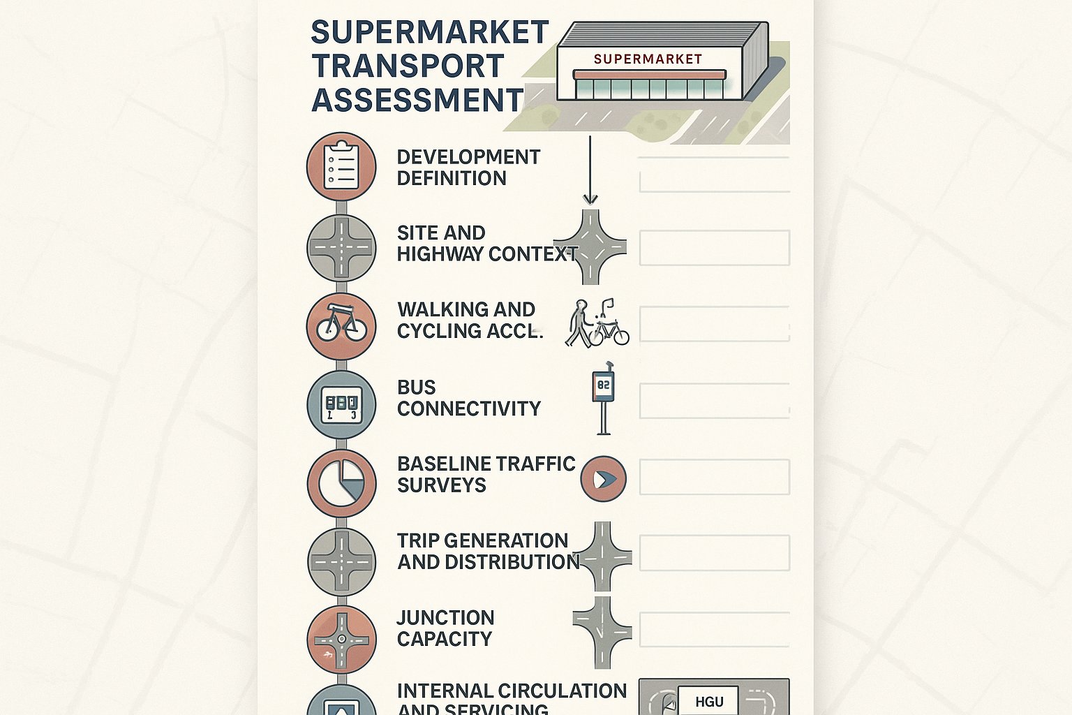
A supermarket transport assessment examines how a proposed foodstore will affect movement to, from and within the site. In practice, that means much more than forecasting extra cars on the road. A robust assessment draws together the full transport picture: accessibility, traffic impact, servicing, parking, walking and cycling conditions, public transport access, and any mitigation needed to make the scheme acceptable.
For most supermarket proposals, we would expect the report to describe the development clearly first. Gross floor area, net sales area, trading format, opening hours, servicing arrangements and access strategy all matter because they shape travel demand. Discount stores, town-centre convenience formats and edge-of-centre superstores do not behave in quite the same way.
From there, the assessment usually covers:
- the site location and surrounding highway context
- local walking, cycling and bus accessibility
- existing traffic conditions and baseline surveys
- trip generation and distribution
- linked trips and pass-by trips
- junction capacity and access performance
- internal circulation and servicing movements
- car and cycle parking demand
- road safety and collision history
- sustainable travel measures and mitigation
The key point is proportionality. A modest extension may not need the same level of modelling as a new standalone supermarket with a petrol filling station and altered junction arrangements. But the document still needs to tell a coherent story: what the development is, how people will reach it, what the likely impacts are, and why those impacts are acceptable in planning terms.
When A Transport Assessment Is Needed For A Supermarket Scheme
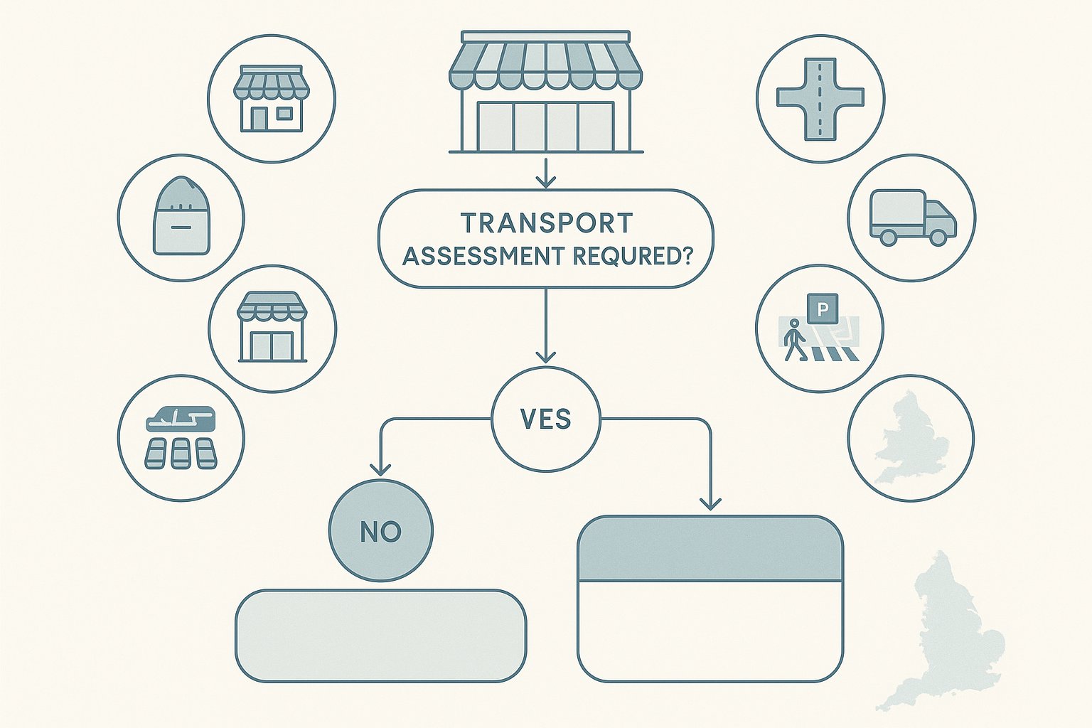
A transport assessment is usually needed where a supermarket proposal is likely to create significant transport effects. That can apply to new-build stores, major extensions, subdivision of retail floorspace, changes of use into food retail, or redevelopment schemes that materially alter traffic generation, servicing activity or parking demand.
The decision is rarely based on floor area alone, although thresholds are often part of the conversation. In England, national guidance supports a proportionate approach: a full transport assessment where impacts are likely to be significant, and a shorter transport statement where they are not. Local planning authorities and highway authorities then refine that through their own validation requirements and standing advice.
For supermarkets, the trigger tends to come from the nature of the use as much as the size. Food retail often generates concentrated arrivals, regular servicing, weekend peaks and short-stay vehicle turnover. Even a relatively moderate store can create planning concern if access is constrained, the local network is already stressed, or nearby walking routes are poor.
We’d normally expect a full assessment where a proposal:
- introduces a new foodstore use
- increases trading floorspace materially
- changes an access arrangement or junction form
- intensifies delivery activity
- relies on parking reconfiguration
- sits on a sensitive or congested network
Early pre-application discussion helps. It’s far easier to agree whether a supermarket transport assessment or transport statement is needed at the start than to discover halfway through design development that the authority expected a wider study area and more evidence.
How Local Planning Policy And Highway Authority Requirements Shape The Scope
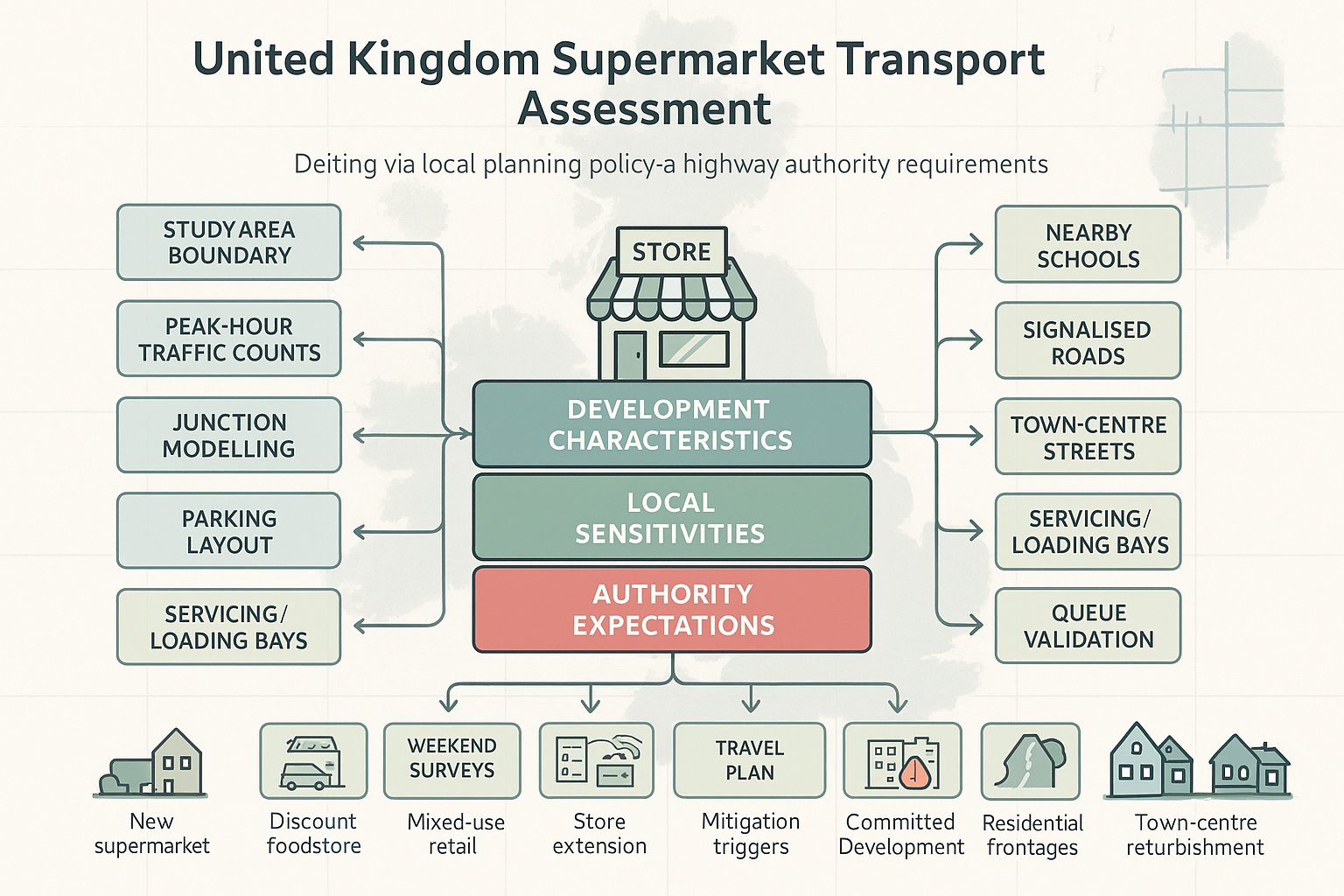
No two supermarket assessments are scoped in exactly the same way, because local policy and highway authority requirements shape the brief from day one. National policy provides the broad framework, but the detail that decides whether a submission lands smoothly usually sits at local level.
Authorities often define, explicitly or implicitly, the study area, peak periods, survey expectations, modelling tools, parking standards, accessibility benchmarks and mitigation thresholds. Some are comfortable with straightforward junction modelling for smaller schemes: others expect a broader network review, particularly where the site sits near committed development, schools, signalised corridors or town-centre constraints.
That has a practical effect on programme and cost. If the authority wants queue length validation, weekend counts, swept-path tracking, delivery management detail and a travel plan, the assessment must be set up to provide it rather than bolt it on later.
For planning teams, the safest approach is to scope around three things:
- Development characteristics, format, floorspace, access, servicing, parking and opening hours.
- Local sensitivities, congestion, safety record, residential frontage, sustainable travel gaps and cumulative growth.
- Authority expectations, validation checklists, local plan policies, design guides and any pre-app feedback.
This is also where experience helps. At ML Traffic, the value is often in matching the report to the relevant authority’s normal threshold, language and concerns, so the submission feels familiar and usable rather than generic.
Key Development Types That Commonly Require Assessment
The schemes most commonly requiring transport assessment are new supermarkets, discount foodstores, mixed-use retail schemes with a supermarket anchor, large extensions to existing stores, and redevelopment proposals that change access or substantially intensify trading activity.
Town-centre refurbishments can also trigger assessment where servicing is tight or public realm changes affect vehicle movement. Likewise, edge-of-settlement stores often attract scrutiny because of car dependence and the need to demonstrate safe pedestrian and cycle access. In other words, the question is not simply “Is it retail?” but “Will this proposal change how the network works?”
Traffic Surveys And Baseline Data Needed For A Robust Submission
Good analysis starts with good evidence. If the survey base is weak, the rest of the supermarket transport assessment becomes vulnerable very quickly. Highway officers usually spot thin data straight away, and once confidence drops, every assumption gets tested harder.
A robust baseline normally includes traffic counts at the key junctions and access points affected by the scheme. Depending on the site, that may mean weekday AM and PM peaks, Saturday peak trading periods, or sometimes all three. For supermarkets, Saturday survey coverage is often essential because that is when shopping-related demand is most visible.
Typical baseline information includes:
- classified turning counts at nearby junctions
- queue length observations and congestion notes
- automatic traffic counts and speed data
- pedestrian and cycle counts
- parking beat surveys or occupancy checks
- bus stop locations, frequencies and journey opportunities
- Personal Injury Collision data, usually over five years
- site photographs and observed driver behaviour
What matters isn’t just collecting data, but making sure the data reflects reality. School holidays, roadworks, temporary traffic management, abnormal weather and seasonal distortion can all undermine confidence if not explained properly.
We also recommend connecting survey findings back to the supermarket format. A discount foodstore with fast turnover and a compact catchment will behave differently from a larger store with complementary concessions and longer dwell times. Baseline analysis should hence do more than present numbers. It should explain how the local network currently functions, where pressure points already exist, and what conditions are likely to influence development impact.
Trip Generation, Linked Trips, Pass-By Trips, And Modal Split
Trip generation is where many supermarket applications are won or lost. Not because the maths is inherently complicated, but because assumptions have to be credible, transparent and rooted in the actual trading format of the proposal.
Most assessments estimate vehicle person trips using a combination of survey databases, comparable sites, local census context, accessibility characteristics and professional judgment. For supermarkets, simply lifting a standard trip rate and applying it rigidly can produce a distorted picture. Foodstores generate a high proportion of trips that are not entirely new to the network.
That is where linked trips and pass-by trips matter. A linked trip is part of a wider journey chain, such as stopping at a supermarket on the way home from work. A pass-by trip is made by traffic already travelling past the site and diverting in briefly. If these effects are ignored, impact can be overstated. If they are pushed too hard, authorities may feel the assessment is trying to make traffic disappear on paper.
The balance has to be defensible. We normally explain:
- the source of base trip rates
- why selected comparators are relevant
- the proportion of linked and pass-by trips assumed
- whether internalisation applies within a wider retail park or mixed-use site
- how modal split reflects local walking, cycling and public transport conditions
Modal split is increasingly important in 2026 because many authorities expect realistic support for non-car access, especially in urban areas. But realism is the word. If the site sits off a fast distributor road with poor crossings and infrequent buses, a very ambitious non-car mode share will not survive scrutiny. Honest assumptions usually travel further than optimistic ones.
Junction Capacity, Access Design, And Internal Layout Appraisal
Once trips are established, the assessment needs to show that the surrounding network and the site itself can operate safely and efficiently. That typically involves junction capacity modelling, access design review and an appraisal of internal circulation.
The scope depends on the proposal. A small extension may only need updated access and parking analysis. A new supermarket with a priority junction, signal changes or a roundabout upgrade will usually require more detailed modelling and geometric review. The key is to test the points where impact could genuinely occur, not to swamp the report with unnecessary modelling that adds little value.
For external junctions, the assessment usually considers:
- existing and forecast traffic flows
- committed development traffic where relevant
- queueing and delay in design years
- sensitivity testing if background growth or trip assumptions are uncertain
- whether mitigation is required to keep operation within acceptable limits
Inside the site, layout matters just as much. Supermarkets fail transport review surprisingly often because the external junction works but the car park doesn’t. Tight aisles, awkward trolley crossing points, poorly separated servicing routes and unclear pedestrian desire lines can all create conflict.
A proper internal appraisal should check entry and exit logic, aisle widths, turning space, visibility, pedestrian routes, disabled access, taxi and pick-up activity if relevant, and whether vehicles can circulate without awkward reversing or queue spillback to the public highway.
Servicing, Delivery Vehicles, And Refuse Collection Considerations
Servicing is one of the most supermarket-specific parts of transport assessment. Food retail relies on regular deliveries, often by large articulated or rigid vehicles, and those movements can drive both amenity and highway concerns.
Planning officers and highway authorities typically want to see that delivery vehicles can enter, manoeuvre, unload and leave in forward gear where possible, without blocking customer circulation or causing queuing on the highway. Swept-path analysis is usually essential, and so is a clear explanation of delivery frequency, timing, loading bay management and refuse collection arrangements.
Where a site sits close to housing, schools or narrow frontages, servicing hours and routing strategy may become as important as geometry. In those cases, the best assessments do not treat servicing as an appendix afterthought: they address it as a core operational issue.
Parking, Cycle Provision, And Pedestrian Accessibility
Parking is rarely just a numbers exercise for supermarket developments. Yes, planners and highway officers will want to know whether the quantity of parking is suitable. But they also want to understand turnover, user mix, layout quality and whether the site works for people arriving by means other than the private car.
A strong submission normally reviews car parking demand against local standards and observed comparator performance. For foodstores, short-stay turnover can be high, and that changes how occupancy should be interpreted. The assessment should consider staff parking, parent-and-child bays, disabled provision, EV charging expectations and whether pick-up or home-delivery activity needs dedicated space.
Cycle parking is another area where detail matters. Token provision tucked behind a substation won’t convince anyone. Good cycle parking should be convenient, secure, visible and matched to likely users. If local policy pushes active travel strongly, poor cycle design can become a disproportionate issue.
Pedestrian accessibility deserves equal weight. We’d usually review:
- footway continuity to nearby residential areas
- crossing opportunities on desire lines
- step-free access and inclusive design
- walking distances to bus stops and local facilities
- wayfinding and public realm quality
This is where many supermarket transport assessments improve markedly when the transport consultant works closely with the architect and civil engineer. Often, small layout tweaks, a better crossing point, a more direct footpath, a clearer cycle route, can remove objections that no amount of narrative would solve.
Road Safety, Walking Routes, And Sustainable Travel Measures
Safety has to run through the whole assessment, not sit in a short section near the end. For supermarket schemes, that means considering existing road safety conditions, likely conflict points created by the development, and how the proposal supports safer walking, cycling and access by public transport.
A standard review will usually include recent collision data on the surrounding network, with attention paid to patterns rather than isolated raw totals. A junction with several shunt-type incidents may tell a different story from one with vulnerable road user collisions near a crossing point. Context matters.
Walking routes are especially important because supermarkets attract a wide mix of users: parents with children, older shoppers, people carrying bags, mobility-impaired users and short local trips on foot. A route may be technically available but still unattractive or unsafe in practical terms if crossings are indirect, lighting is poor or footways narrow beside fast traffic.
Typical sustainable travel measures include:
- improved pedestrian crossings
- widened or resurfaced footways
- better cycle parking and links
- bus stop upgrades or stop clearways
- travel plan measures for staff
- signage and wayfinding improvements
The trick is not to over-promise. Sustainable travel measures should be relevant to the site and proportionate to the impact. A concise, well-targeted package usually carries more weight than a long wish list with no clear delivery route. Authorities want to see that the measures are practical, funded where necessary, and genuinely connected to how the supermarket will operate.
How Supermarket Assessments Differ From Other Retail Transport Studies
Supermarket transport work shares a foundation with wider retail assessment, but supermarkets have distinct characteristics that change the analysis. If those differences are missed, the report can feel generic very quickly.
First, trading patterns are different. Supermarkets often generate stronger Saturday peaks, sharper short-stay turnover, and regular repeat visits from a local catchment. The traffic profile may not align neatly with standard weekday retail assumptions.
Second, linked and pass-by trip behaviour is usually more significant. Many supermarket visits are folded into existing journeys, especially commuter and school-run patterns. That needs careful handling because it can materially affect net impact at nearby junctions.
Third, servicing is heavier and more operationally sensitive. Deliveries, cage handling, loading bay design, refuse collection and sometimes home-delivery vans all create transport issues that many non-food retail units simply do not generate to the same degree.
Fourth, internal layout tends to matter more. A foodstore car park often has high turnover, trolley movement, family parking demand and frequent interaction between pedestrians and vehicles. What looks acceptable for a bulky goods unit might perform poorly for a supermarket.
And finally, supermarkets can attract stronger scrutiny around accessibility and local centre impact, especially if they sit in edge-of-centre locations. So while the methodology may sound familiar, a supermarket transport assessment normally needs a more operational, site-specific lens than a generic retail study.
Common Reasons Supermarket Transport Assessments Are Challenged
Most challenges come down to one issue: lack of confidence. If the authority feels the assessment is selective, too generic or unsupported by evidence, questions follow fast.
The most common weak spots are poor or outdated survey data, unclear scoping, and trip assumptions that feel too convenient. A supermarket proposal might present low net traffic growth, for example, but if the linked-trip reduction is not backed by suitable evidence, officers are unlikely to accept it. The same applies to comparator site selection. If the chosen stores do not resemble the proposed format, the trip rates will be questioned.
Other frequent challenge points include:
- modelling only one junction when the impact is clearly wider
- ignoring Saturday peak conditions
- weak servicing evidence or no swept-path analysis
- parking assessments that rely on standard ratios without occupancy review
- limited pedestrian accessibility analysis
- mitigation that is vague, undeliverable or detached from the identified issue
There is also a softer problem: inconsistency between reports. If the transport assessment says one thing, the planning statement implies another, and the drawings show a third version of the access arrangement, confidence disappears. We’ve seen otherwise decent applications slowed simply because the documentation was not aligned.
The fix is rarely flashy. Early agreement on scope, robust surveys, transparent assumptions and coordination across the consultant team usually prevent most objections before they start.
What To Include In A Planning-Ready Supermarket Transport Assessment
A planning-ready submission should be clear enough for a case officer to follow, technical enough for a highway engineer to trust, and focused enough that the main points do not get buried. That sounds simple, but it takes discipline.
At a minimum, a supermarket transport assessment should include a concise description of the proposal, the policy and scoping context, and an explanation of why the level of assessment is proportionate. From there, it should set out the baseline transport conditions using current survey evidence, then move logically into trip generation, trip distribution, assignment and impact testing.
A strong report will normally include:
- development description and site context
- relevant national and local policy framework
- agreed scoping assumptions where available
- baseline traffic, parking, safety and accessibility data
- trip generation with linked/pass-by treatment explained
- junction capacity and access appraisal
- internal layout and servicing review
- parking, cycle and pedestrian assessment
- sustainable travel measures and mitigation
- a clear conclusion on transport acceptability
The conclusion should not be woolly. It should state, in plain terms, whether the development is acceptable in transport terms, what mitigation is proposed, and whether any residual impacts would be severe. That planning language matters.
If the report can answer the obvious authority questions before they are asked, it is doing its job. And in our experience, that is what gets approvals moving faster: not a longer document, but a sharper one.
For teams preparing a new store, extension or retail redevelopment, the goal isn’t merely to submit a supermarket transport assessment. It’s to submit one that feels complete, locally tuned and decision-ready from the first read.
Supermarket Transport Assessment FAQs
What is a supermarket transport assessment and why is it important?
A supermarket transport assessment evaluates the impact of a proposed supermarket on local transport, including traffic, access, servicing, parking, safety, and sustainable travel. It ensures the development operates safely and efficiently within the local highway network, facilitating smoother planning approvals.
When is a supermarket transport assessment typically required?
It is usually required for new supermarkets, major extensions, changes of use increasing traffic or servicing, or redevelopment schemes that alter access or parking demand, particularly when significant transport effects on the local network are expected.
What key elements are covered in a supermarket transport assessment?
The assessment covers site accessibility, trip generation including linked and pass-by trips, traffic impact, junction and access performance, internal circulation, parking demand, pedestrian and cycle access, servicing and delivery arrangements, road safety, and sustainable travel measures.
How do local planning policies influence the scope of a supermarket transport assessment?
Local planning authorities and highway agencies define study areas, peak survey periods, modelling tools, parking standards, and mitigation requirements. These local policies tailor the assessment scope and ensure it meets specific regional expectations and transportation challenges.
How does a supermarket transport assessment differ from other retail transport studies?
Supermarket assessments focus more on sharper peak-hour shopping traffic, high delivery servicing demands, linked and pass-by trips, and internal layout considerations like trolley routes and pedestrian interaction, reflecting the unique operational patterns of foodstores compared to other retail types.
What common issues can cause supermarket transport assessments to be challenged or delayed?
Common challenges include outdated or insufficient survey data, unrealistic trip generation assumptions, inadequate junction modelling, weak servicing evidence, poor parking and pedestrian accessibility analysis, and vague or undeliverable mitigation proposals, impacting the confidence of planning authorities.