Planning officers rarely worry about a transport report in the abstract. What they worry about is what actually happens on the street outside a site: queues at the junction, cars circling for spaces, pedestrians stepping into the carriageway, neighbours complaining that the busiest period was never properly assessed. That is exactly why a synagogue transport assessment needs to be more tailored than a standard place-of-worship report.
In practice, synagogue proposals often produce travel patterns that don’t fit neatly into ordinary weekday assumptions. Friday evening arrivals can be sharp and compressed. Shabbat can mean a high walking mode share in some communities, while still creating kerbside set-down demand before and after services. Add education uses, community functions, weddings, funerals, and High Holy Day peaks, and the planning picture becomes far more nuanced than a simple floorspace calculation.
For architects, planners, solicitors, developers, surveyors, and councils, the key issue in 2026 is not whether a report exists, but whether it reflects real use. We’ve seen that local authorities respond best when the evidence is site-specific, honest about peak conditions, and tied to practical mitigation. At ML Traffic, that has long been the focus: concise, accurate transport reporting shaped around local thresholds and real planning risks rather than boilerplate.
This guide sets out what planning authorities typically expect, when a synagogue transport assessment is needed, what evidence usually matters most, and how to deal with common concerns before they become objections.
When A Synagogue Transport Assessment Is Needed
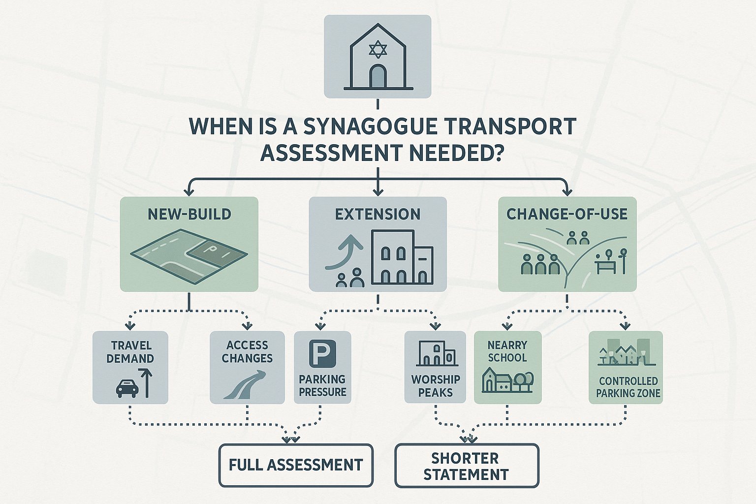
A synagogue transport assessment is usually required where a proposal could materially affect travel demand, access arrangements, or parking conditions. In some cases the local authority will ask for a full Transport Assessment: in others, a shorter Transport Statement will do. The difference tends to come down to scale, local sensitivity, and whether the likely effects can be dealt with through proportionate evidence.
For synagogue schemes, the most common triggers are straightforward: a new-build development, an extension that increases capacity, or a change of use that intensifies attendance patterns. But the planning judgement is rarely based on one number alone. Authorities are increasingly interested in whether the proposal changes how the site functions over the week, especially around worship periods, education sessions, and community events.
A modest extension on a wide road with plentiful off-street parking may need relatively light evidence. A similar extension on a narrow residential street near a school, a controlled parking zone, or a sensitive junction may need much more robust analysis. That is why we usually advise looking beyond floorspace thresholds at the start.
Local plans, parking standards, and transport supplementary planning documents often provide the formal trigger points. Even so, officers can request a synagogue transport assessment below those thresholds if they consider the local context constrained or the use pattern atypical.
Typical Planning Triggers For New Build, Extension, And Change-Of-Use Schemes
The clearest trigger is a new-build synagogue, particularly where regular worship, classrooms, function space, offices, or ancillary community uses are proposed together. New sites create a fresh trip pattern, and planning authorities will want to know how people arrive, where they park, how drop-off activity works, and whether nearby junctions can absorb the demand.
Extensions are another common trigger. An increase in prayer hall space, extra seating, enlarged halls, or more educational accommodation can all intensify use. Sometimes the issue is not average daily activity but a sharper peak after expansion, especially if the larger building enables more simultaneous functions.
Change of use can be even more sensitive. Converting a shop, office, warehouse, or former community building into a synagogue may be acceptable in principle, but transport effects often differ materially from the lawful use. A site that previously generated spread-out weekday trips may instead produce concentrated arrivals around services or event times.
Authorities also look closely at proposals that worsen access, intensify parking demand, or introduce larger gatherings than an existing consent envisaged. If nearby streets already experience parking stress, or if the proposal sits close to schools, busy crossings, or substandard junctions, expect the need for stronger evidence.
How Synagogue Travel Patterns Differ From Other Community Uses
One reason a synagogue transport assessment needs care is that synagogue travel patterns often don’t resemble those of a generic hall, church, or community centre. The use may look similar in land-use terms, but the transport reality can be quite different.
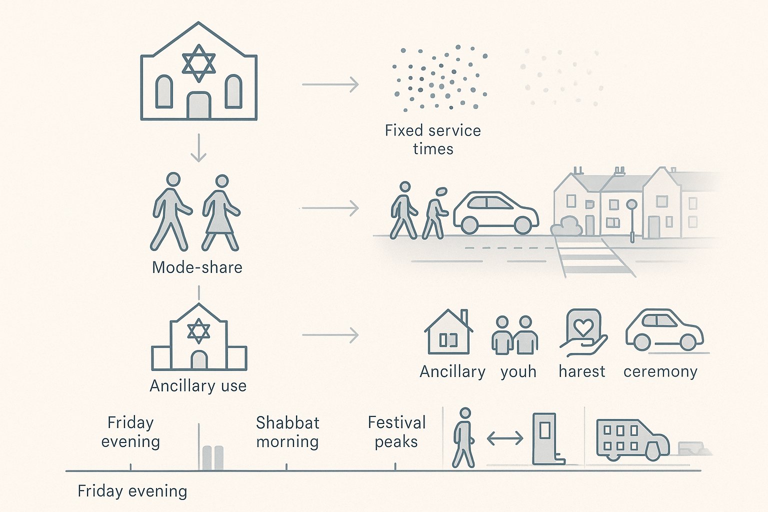
The first difference is the strength of fixed-time demand. Services begin at defined times, so arrivals are often concentrated into short windows rather than dispersed across an hour or two. That can create intense but brief pressure on crossings, footways, side roads, and kerb space.
The second difference is mode choice. In observant communities, Shabbat restrictions can produce a very high walking mode share, which may reduce parking demand during certain periods but increase the need for safe, direct pedestrian routes. At the same time, some worshippers, visitors, elderly attendees, or those travelling from farther away may still arrive by car before or after key periods, so it would be a mistake to assume zero vehicular impact.
Then there are ancillary uses. Many synagogues are not just places of worship: they may include education, youth activity, social events, charitable functions, and lifecycle ceremonies. Those uses can alter demand profiles substantially and may be the part of the proposal that generates the greatest planning concern.
Peak Arrival And Departure Periods Around Services, Festivals, And Events
Peak periods matter because they often drive the planning outcome. A local authority is less interested in whether a street is quiet at 2pm on a Tuesday than in whether it operates safely and acceptably during the busiest realistic conditions.
For many synagogues, Friday evening is one of the most important peaks. Arrivals can cluster close to sunset, producing a compressed demand profile. Some attendees walk, others are dropped off, and those who drive may seek spaces quickly in nearby streets. The result can be a short burst of activity that standard weekday surveys simply miss.
Shabbat morning is another key period. Depending on congregation size and observance patterns, arrival peaks may be more gradual than Friday evening, but departures can bunch after the service and any associated gathering such as kiddush. That creates a different transport effect: more crossing movements, more doorstep activity, and potential conflicts at site access points.
Festival periods and major events complicate things further. High Holy Days can generate attendance levels materially above a normal week. Weddings, bar and bat mitzvahs, funerals, and large community programmes can also produce one-off or recurring peaks with higher car use than routine worship. A robust synagogue transport assessment needs to distinguish between regular conditions, predictable seasonal peaks, and event-led demand rather than blending them into one average.
Key Issues Assessed In A Synagogue Transport Assessment
A sound synagogue transport assessment should explain not just how many trips are expected, but how those trips interact with the site, the street, and the surrounding area. In 2026, planning authorities generally expect a more rounded appraisal than a simple traffic count and parking estimate.
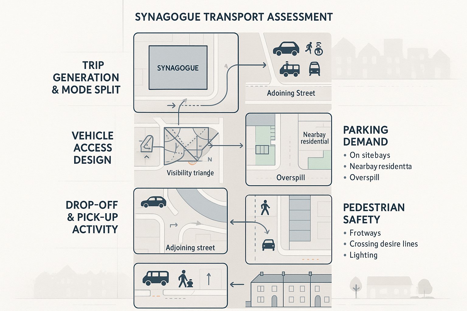
The starting point is usually trip generation and mode split: how many people attend, when they arrive and leave, and whether they walk, drive, share lifts, use public transport, cycle, or rely on taxis and community transport. From there, the assessment should examine whether the site layout and local network can accommodate those movements safely.
Access design is central. Officers will want confidence that vehicles can enter and leave without awkward manoeuvres, reversing conflicts, or visibility problems. Where servicing, refuse collection, or security arrangements affect circulation, those issues need to be explained clearly.
Parking is almost always scrutinised, but it should be considered honestly. Under-provision can create overspill and resident objection: over-provision may conflict with policy aims if the site is in an accessible location. The right answer is usually evidence-led rather than formulaic.
Pedestrian movement is equally important. A scheme with a high walking share still needs enough footway capacity, safe crossing opportunities, and sensible interaction between people and vehicles at the frontage.
Vehicle Access, Parking Demand, Drop-Off Activity, And Pedestrian Safety
Vehicle access is more than a geometry exercise. Yes, the assessment should cover visibility splays, gate positions, swept paths, and whether two-way movement is workable. But authorities also look at how the access operates at the moments that matter most. If several cars try to turn in during a compressed pre-service window, does queuing spill back onto the carriageway? If a refuse vehicle arrives at the same time as worshippers are departing, is there a conflict?
Parking demand needs a similarly practical approach. On-site spaces should be reviewed against local standards, but that is only part of the picture. The real planning question is whether likely demand can be absorbed without harmful overspill into surrounding streets, especially where residents already experience stress. Parking beat surveys, accumulation profiles, and observations of turnover all help here.
Drop-off and pick-up activity can be the hidden issue on synagogue schemes. Even where many attendees walk, there may still be short-stay set-down demand for older people, children, disabled users, and visitors. Without designated or managed kerbside space, vehicles may stop informally, obstruct driveways, or narrow the running lane.
On pedestrian safety, officers usually expect more than a passing note. Footway widths, crossing desire lines, lighting, passive surveillance, and the interface with security measures all matter. If children walk from nearby homes or schools, or if older worshippers use mobility aids, the assessment should say so plainly and show how the design responds.
Survey Data And Evidence Usually Required
Evidence quality often determines whether a synagogue transport assessment feels credible. A technically neat report can still fall apart if the survey base ignores the actual busiest periods. Planning authorities know this, and objectors certainly do.
Most applications need multi-day traffic and parking surveys covering the streets most likely to be affected, not just the road directly outside the site. Depending on local conditions, that may include beat surveys of on-street parking, automatic traffic counts, turning counts at nearby junctions, and site observations of arrival and departure patterns.
Attendance evidence is usually just as important as highway data. Occupancy counts for services, classes, and events help establish realistic trip generation. Where an existing synagogue is being extended, observed attendance by time of day and day of week is often the strongest evidence available. For proposed relocations or new communities, comparable site data and transparent assumptions become more important.
Public transport and active travel evidence should also be included. Distance to bus stops and rail stations, service frequency, walking routes, step-free access, and cycle parking provision all influence the mode split case.
Where local concern is high, we often find that clearly presented evidence matters as much as the surveys themselves. If residents and officers can follow the methodology, the discussion becomes far more constructive.
How Friday Evenings, Weekends, And Seasonal Religious Events Affect Data Collection
This is where many weaker reports miss the mark. If surveys only cover standard weekday AM and PM peaks, they can materially understate synagogue demand. A proper synagogue transport assessment should normally include Friday PM, weekend/Shabbat periods, and, where practicable, at least one relevant festival or event condition.
Friday evening is especially important because arrivals may be brief, intense, and tied to sunset rather than a fixed civil time throughout the year. Survey timing should reflect that seasonal reality. A count from 5pm to 6pm may be useful in one month and much less so in another.
Weekend data matters too. Shabbat morning conditions often differ from weekday operations in parking availability, pedestrian volume, and background traffic. A street that seems manageable on a Tuesday may operate very differently on a Saturday when residents are home and kerbside occupancy is already high.
Seasonal events require judgement. High Holy Day counts are not always practical, but authorities still expect them to be addressed. In those cases, robust forecasting based on synagogue attendance records, ticketing or registration data, and comparable sites can be acceptable, provided the assumptions are transparent and sensitivity-tested.
In short, the evidence base should reflect how the building is truly used, not merely when it is easiest to survey.
Assessing Impact On The Local Highway Network
Once the survey base is established, the next step is to assess whether the proposal creates a material effect on the surrounding network. That means looking beyond gross attendance numbers and focusing on the difference between the proposed use and the site’s existing lawful or consented baseline.
That baseline comparison is critical. A change-of-use from office to synagogue, for example, may reduce daily vehicle trips overall while still increasing short-duration parking pressure at particular times. Planning authorities generally want both points acknowledged: the scheme may be beneficial in one respect and more sensitive in another.
Trip assignment should then show where vehicle movements are likely to come from and which routes they will use. If there is concern about a nearby junction, mini-roundabout, school frontage, or narrow residential road, capacity and operational effects should be tested at the relevant periods. Depending on complexity, that may involve junction modelling, queue analysis, or a more qualitative operational review.
Parking effects also sit within network impact. If on-site parking is limited, the assessment should quantify likely accumulation on surrounding streets and explain whether overspill can be absorbed without causing severe inconvenience or safety issues.
Mitigation should be practical, not decorative. Authorities respond better to specific measures such as revised access geometry, waiting restrictions, marked drop-off space, event management procedures, volunteer stewarding, travel planning, or timed servicing restrictions than to vague promises of “monitoring”.
And importantly, network assessment should reflect synagogue-specific peaks. If the busiest realistic condition is Friday evening rather than the weekday PM peak, that is the scenario that needs testing. Otherwise the report may be technically complete but planning-wise unconvincing.
Sustainable Travel, Accessibility, And Inclusive Access Considerations
Transport planning for synagogues is not just about avoiding traffic problems. It is also about showing that people can reach the site safely, conveniently, and inclusively. In 2026, planning authorities increasingly expect this part of the report to be substantive rather than a standard policy paragraph.
For many synagogue proposals, walking is fundamental. If a significant share of worshippers live locally, the quality of footways, crossing points, lighting, gradients, and wayfinding becomes central to the planning case. A high walk mode share is a strength, but only if the local environment supports it safely.
Public transport accessibility should also be assessed properly. Bus stop locations, rail access, service frequency, hours of operation, and step-free availability all matter, especially for weekday services, staff, visitors, and event attendees travelling from further afield.
Inclusive access deserves particular care. A synagogue may serve older worshippers, children, disabled users, and people with temporary mobility limitations. That means step-free routes from parking and set-down points, suitable gradients, disabled bays near the entrance, enough space for mobility aid users, and clear pedestrian priority where vehicles and people mix.
Cycle access can be relevant too, especially in urban areas, but provision should be realistic: secure, convenient, and overlooked rather than tokenistic.
Where we prepare these reports, we find that this section often helps bridge planning and community objectives. It shows not only how impacts are controlled, but how the scheme supports dignified access for the people who actually use it.
Common Planning Concerns And How To Address Them Early
Most objections to synagogue proposals are predictable. That is actually good news, because predictable concerns can be addressed early if the transport work is honest and site-specific.
The most common issue is parking stress. Neighbours often fear that worshippers or event guests will occupy already limited kerbside space. The best response is rarely argument: it is evidence. Transparent parking beat surveys, clear accumulation charts, and a frank explanation of regular versus exceptional demand can defuse a lot of tension. If pressure remains, a parking management plan, controlled event procedures, or discussion with the highway authority about local controls may be needed.
Congestion and drop-off activity are also frequent concerns, particularly on narrow roads. Here, layout design, swept path review, set-down strategy, and stewarding arrangements can make the difference. Sometimes a small design amendment, such as relocating gates or formalising a drop-off point, resolves an issue that would otherwise dominate the application.
Noise and disturbance may arise where evening events or departures affect nearby homes. End-time management, marshalling, communication with attendees, and sensible dispersal arrangements should be built into the operational plan rather than added as an afterthought.
Another recurring issue is the interaction with school traffic or sensitive pedestrian environments. If the site is close to a school gate, narrow footways, or a difficult crossing, the assessment should directly address timing overlap, child safety, and whether staggered activity or access changes are needed.
In our experience, the strongest planning submissions do not pretend there is no impact. They identify the likely pressure points early, quantify them properly, and set out mitigation that officers can condition and communities can understand.
Conclusion
A robust synagogue transport assessment is not a generic planning attachment. It is a focused piece of evidence that reflects real worship patterns, real peak conditions, and the real character of the surrounding streets.
In 2026, planning authorities typically expect three things: accurate baseline evidence, analysis tied to synagogue-specific peaks such as Friday evenings and Shabbat, and mitigation that is practical enough to work on the ground. Where those elements are missing, even a modest scheme can face delay. Where they are handled well, the transport case becomes clearer, more defensible, and far easier for officers and local residents to engage with.
For architects, planners, developers, councils, and legal teams, the message is simple: start early, scope the surveys around actual religious use, and don’t rely on standard weekday assumptions. A well-prepared report can do more than satisfy validation requirements: it can remove uncertainty from the planning process and help a proposal move forward with confidence.
Synagogue Transport Assessment FAQs
What is a synagogue transport assessment and why is it important?
A synagogue transport assessment is a specialised report evaluating how a synagogue proposal affects local travel, parking, and road safety. It is important because synagogue use patterns often differ from typical community buildings, with peak times and unique travel modes requiring tailored analysis.
When is a synagogue transport assessment typically required by planning authorities?
It is generally required for new-build synagogues, extensions increasing capacity or community uses, change of use to synagogue, or when proposals may intensify parking or access pressures, especially on constrained streets or near sensitive sites like schools.
How do synagogue travel patterns differ from other places of worship or community centres?
Synagogue travel patterns have sharply defined peak arrival times, like Friday evening near sunset and Shabbat mornings. Many attendees walk due to Shabbat restrictions, but kerbside drop-off demand remains. Ancillary uses like education and lifecycle events add varied trip profiles not typical of generic halls.
Why must survey data for a synagogue transport assessment include Fridays, weekends, and festival periods?
Because religious attendance peaks often occur on Friday evenings close to sunset, Shabbat mornings, and on festival days. Surveys limited to weekday peaks underestimate true demand and miss critical times when transport and parking impacts are greatest.
What key issues are assessed in a synagogue transport assessment?
Assessments review trip generation and mode share, vehicle access and layout, parking demand including overspill, drop-off activity, pedestrian safety, and inclusive access considerations. They also evaluate impact on the local highway network and propose practical mitigation measures.
How can planners address common local concerns like parking stress and congestion around synagogues?
By providing transparent, site-specific evidence such as parking beat surveys and accumulation charts, and offering practical solutions like parking management plans, designated drop-off zones, stewarding for events, and traffic calming measures tailored to observed peak conditions.