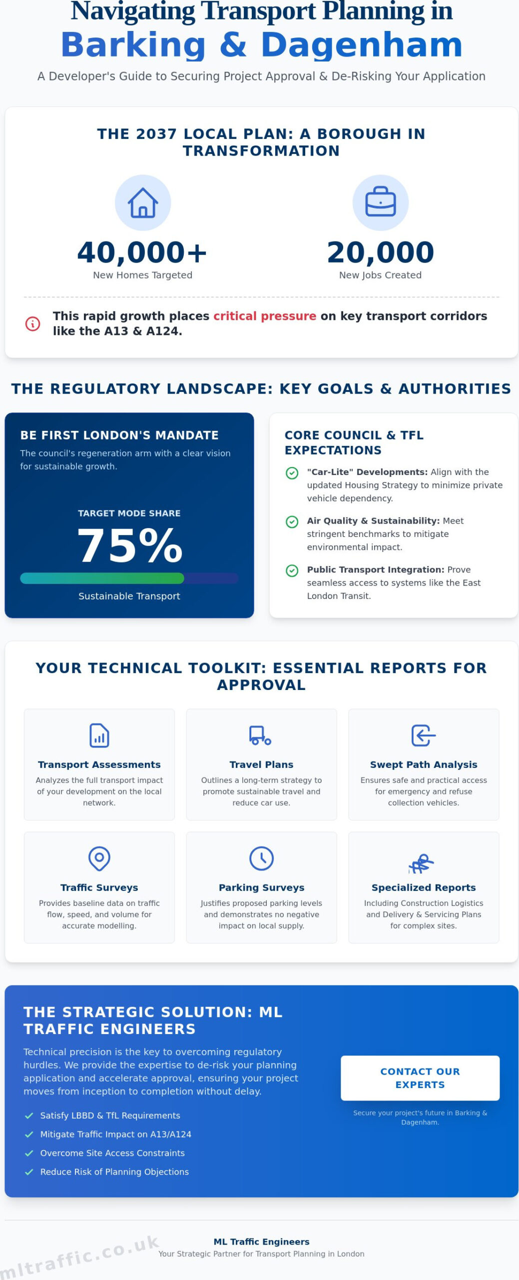
Data collection costs for transport assessments have surged by 15% since 2024, yet many developers still face costly delays due to unpredictable highway officer demands. You’ve likely experienced the frustration of a project stalling because of borough-specific parking stress requirements or technical disputes over site access. In the high-stakes regulatory environment of London and the Home Counties, technical precision is a functional necessity rather than a luxury. This guide identifies the most frequent common transport issues in planning applications and provides the technical strategies needed to resolve them effectively.
We’ll examine the critical 2026 mandates, including the requirement for 100% active EV charging and the strict car-free rules for areas with a PTAL of 4 or higher. You’ll learn how to use professional parking surveys, swept path analysis, and robust transport statements to provide the validated data authorities require. By aligning your technical documentation with the latest NPPF standards and local borough expectations, you can transform transport objections into a clear path toward swift planning approval and cost-effective delivery.
Key Takeaways
- Master the shift toward ‘Vision and Validate’ policies to resolve common transport issues in planning applications and avoid summary refusal.
- Utilize Swept Path Analysis to validate site access designs and prove manoeuvrability for service vehicles on constrained urban sites.
- Identify how PTAL ratings of 4 or higher dictate your development’s density and the necessity of car-free mandates.
- Build a defensible evidence base using TRICS forecasting and traffic surveys to satisfy the demand for rigorous technical data.
- It’s vital to understand how Section 278 and Section 38 agreements turn technical highway objections into viable planning conditions.
Table of Contents
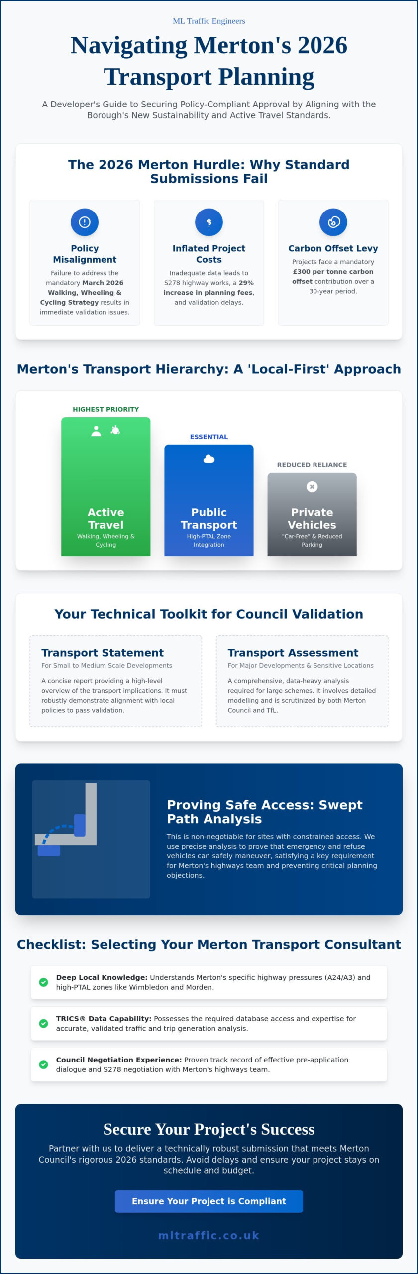
Why Transport Issues Delay Planning Applications in 2026
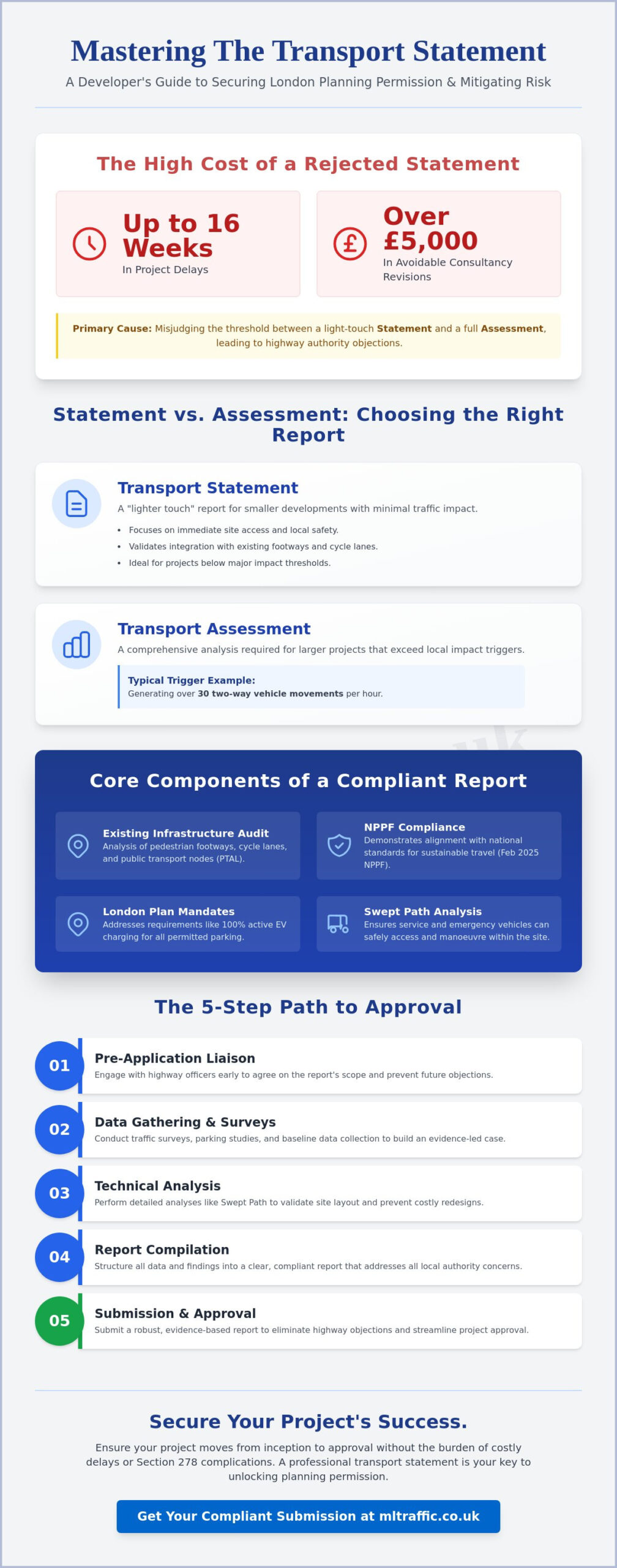
The UK planning system underwent a fundamental shift in 2026, moving decisively from the traditional "Predict and Provide" model to a "Vision and Validate" approach. This change means local authorities no longer simply look at how much traffic a development will create and ask for more road space. Instead, they require developers to set a sustainable vision for travel and prove how it will be achieved. Failure to adapt to this methodology is one of the most common transport issues in planning applications today. When a project doesn’t align with these modern expectations, highway officers often recommend summary refusal based on inadequate site access, safety concerns, or a lack of sustainable infrastructure.
Securing consent requires a deep understanding of the transportation planning process and how it integrates with local policy. Developers must distinguish between a Transport Statement for smaller schemes and a full Transport Assessment for residential developments of 80 units or more. Engaging with these requirements during the early RIBA stages prevents the need for expensive structural redesigns later in the project lifecycle. Technical documentation must be precise, data-driven, and ready to withstand rigorous scrutiny from statutory consultees.
To better understand when to involve technical experts in your project, watch this helpful video:
The Statutory Role of the Local Highway Authority
In London and the Home Counties, the Local Highway Authority (LHA) acts as a critical guardian of public safety and network capacity. Highway officers possess the power to stall an application if they believe the "safety and capacity" of the existing road network is compromised. We recommend seeking pre-application advice to identify site-specific constraints before submitting formal plans. This proactive step allows us to tailor our Transport Statements and Assessments to address the LHA’s specific concerns regarding local junctions or pedestrian safety zones.
NPPF vs. Local Plan: The Hierarchy of Objections
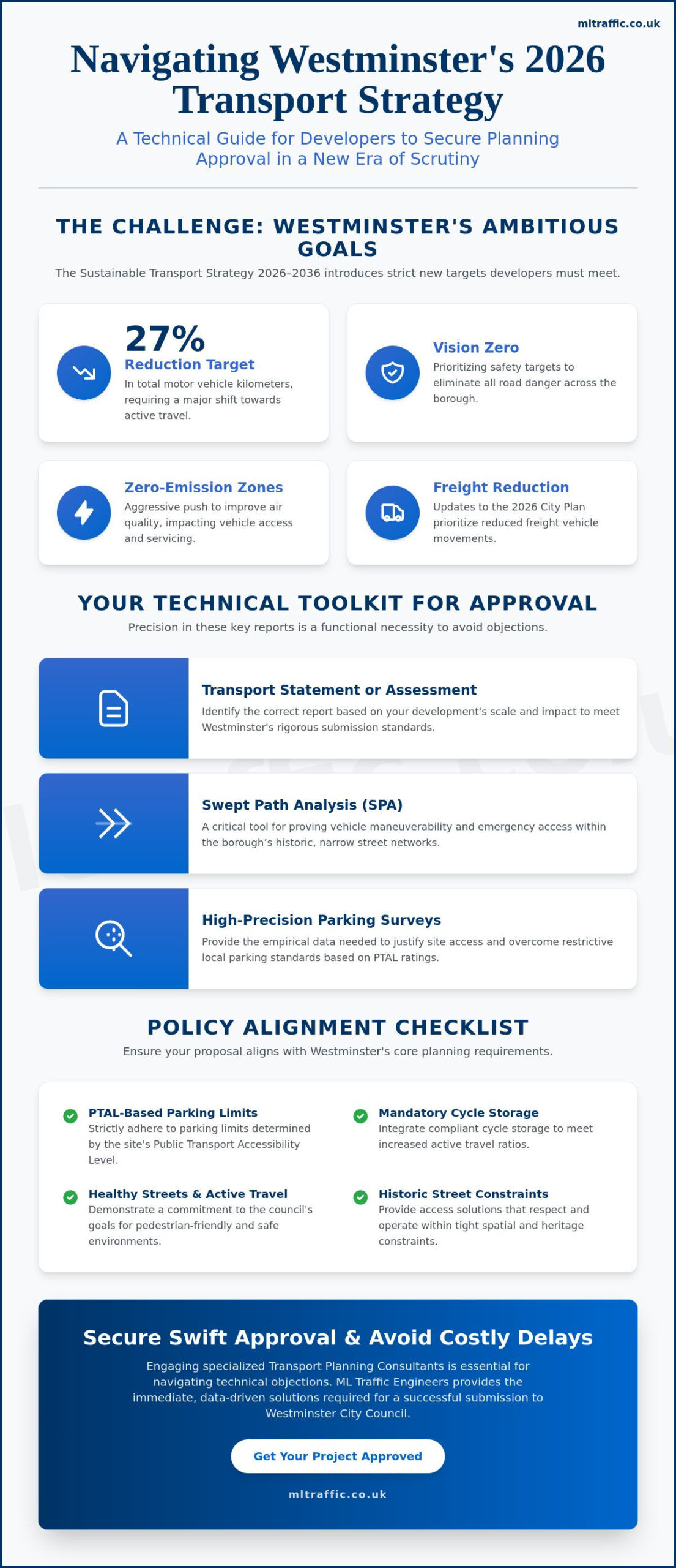
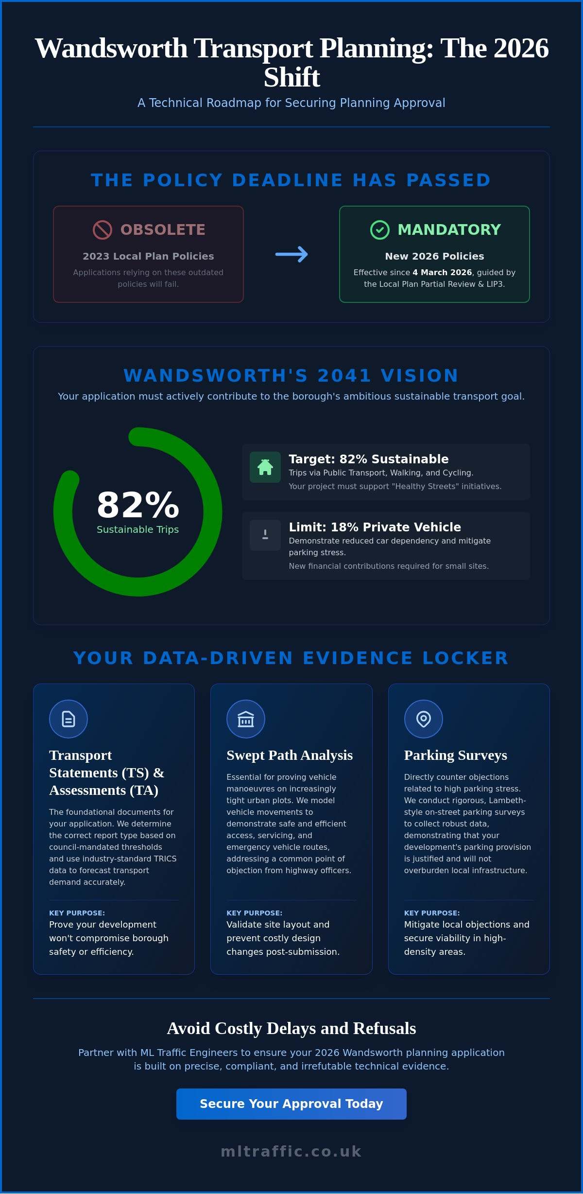
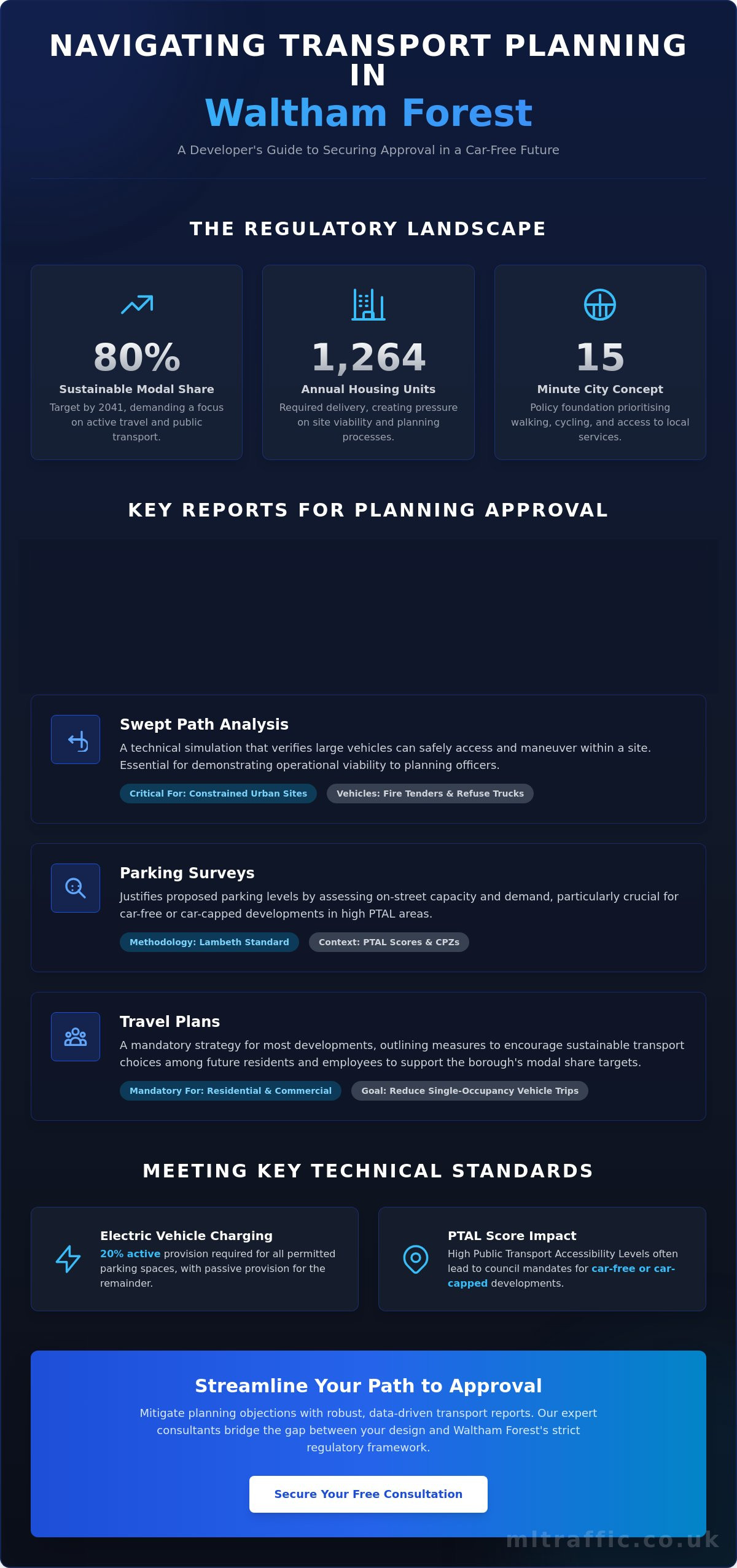
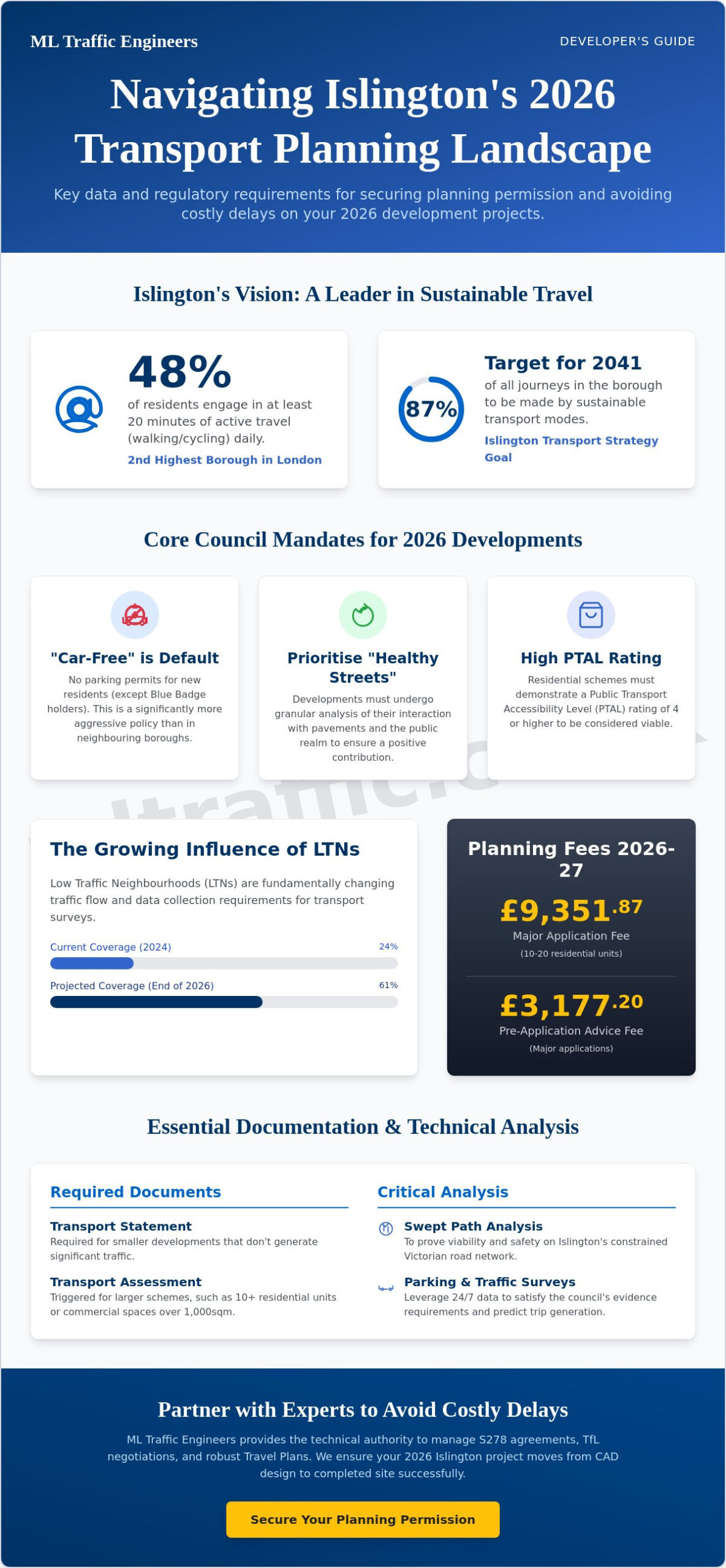
The National Planning Policy Framework (NPPF) remains the primary guide for development in England. It states that development should only be prevented on transport grounds if the residual cumulative impacts on the road network would be "severe." However, local plans often impose stricter requirements. The 2026 London Plan, for instance, now mandates 100% active electric vehicle charging points for all permitted spaces and enforces car-free developments in areas with a Public Transport Access Level (PTAL) of 4 or higher. In the context of transport planning, sustainable development is defined as a project that prioritises active travel and public transport integration to meet current needs without increasing long-term car dependency. Adhering to these benchmarks is non-negotiable for securing planning approval in the current regulatory climate.
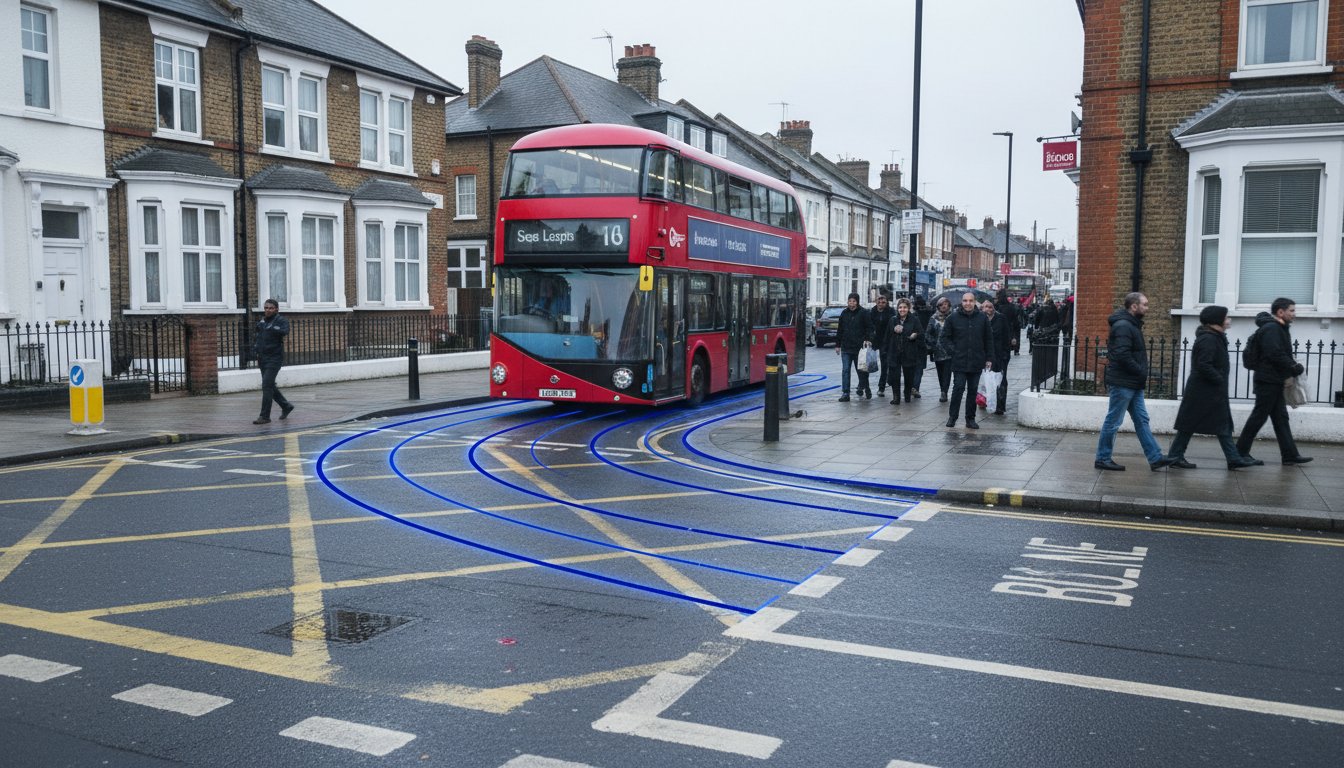
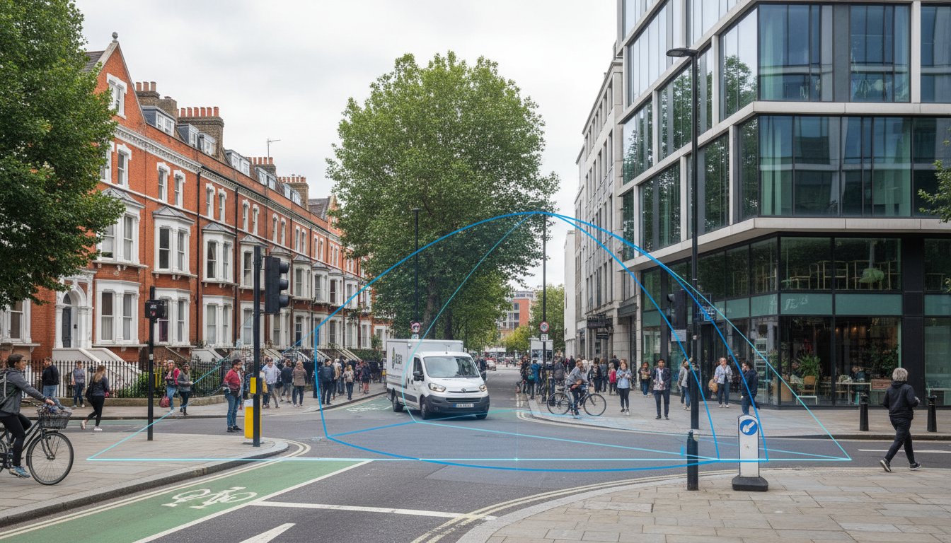
Access and Manoeuvrability: The Swept Path Analysis Hurdle
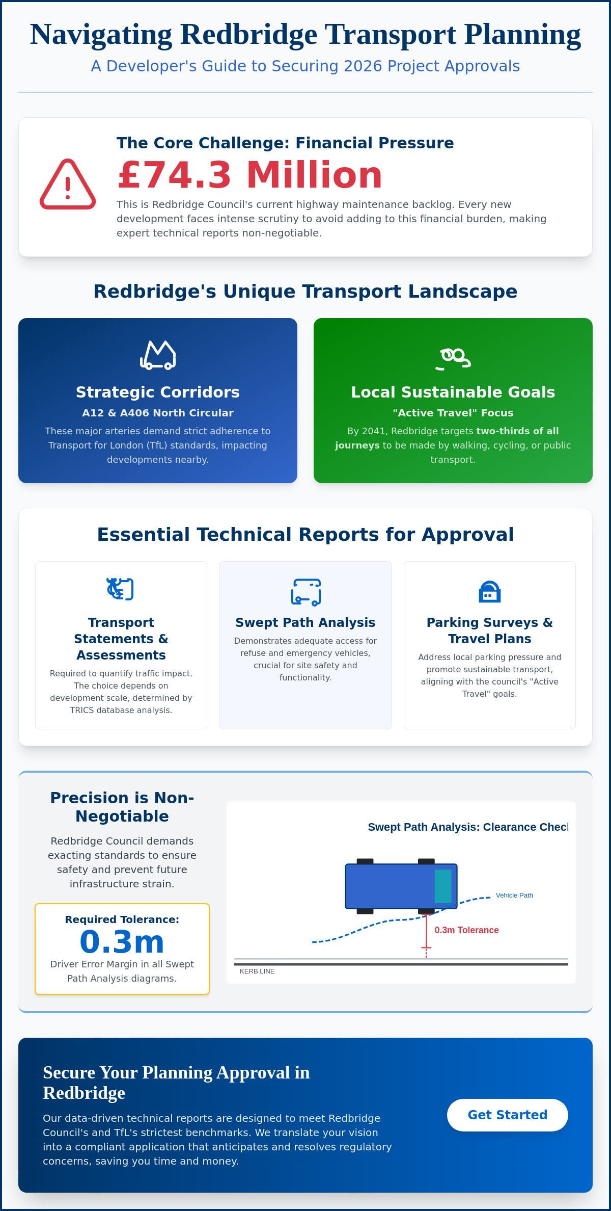
Urban infill developments face unique challenges, primarily regarding the physical constraints of existing streetscapes. Inadequate site access remains one of the most common transport issues in planning applications, often leading to technical objections that can stall a project indefinitely. To overcome these hurdles, developers must provide empirical evidence that vehicles can enter, turn, and exit the site safely. Swept Path Analysis (SPA) is the industry standard for providing this proof, using digital modelling to simulate the movement of specific vehicle templates within your site’s footprint.
Precise SPA drawings prevent the risk of receiving an "undeliverable" planning consent. A permission that looks good on paper but fails to account for the turning circle of a refuse freighter will inevitably fail at the construction or operational stage. The UK government guidance emphasises the role of technical assessments in mitigating development impacts, but local authorities now demand high-resolution digital simulations over static, manual drawings. Our team provides the comprehensive technical reporting required to validate these designs before they reach the highway officer’s desk.
Proving Fire Tender and Refuse Access
By 2026, London Boroughs have largely phased out the acceptance of manual tracking diagrams. Emergency vehicle access is a non-negotiable safety requirement, specifically regarding the turning circles and weight tolerances for fire tenders. Refuse freighters also require significant space, and failure to prove their manoeuvrability often results in a recommendation for refusal. Utilising professional Swept Path Analysis Services in London ensures your site layout accounts for the 2026 standards for both emergency and service vehicle templates, including the increasingly common long-wheelbase delivery vans.
Visibility Splays and Junction Design
Visibility splays are the sightlines required for drivers to see and be seen when exiting a site. These are calculated based on safe stopping distances, which must be supported by local speed survey data. Street furniture, existing landscaping, and third-party land often obstruct these splays, creating significant planning friction. However, technical data can often justify narrower access points, particularly in heritage or sensitive areas. By using precise traffic surveys to document actual local speeds, we can often negotiate reduced visibility requirements that preserve the aesthetic character of a site without compromising safety standards. This data-led approach turns subjective objections into objective, manageable planning conditions.
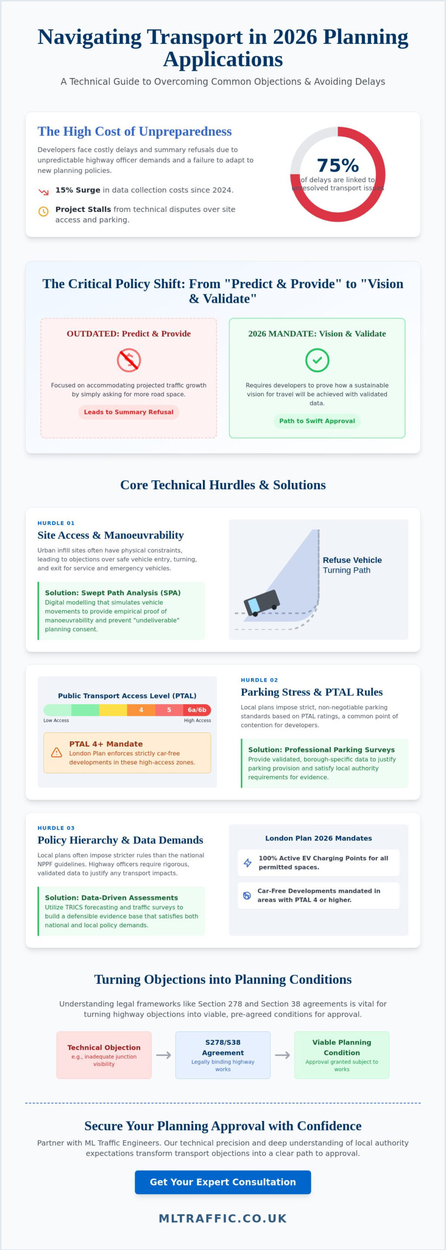
Navigating Parking Stress and PTAL Constraints
The Public Transport Accessibility Level (PTAL) system serves as the primary metric for determining development density and allowable parking provision across London. Under the 2026 London Plan, sites with a PTAL rating of 4, 5, or 6 are strictly mandated as car-free developments. This policy aims to eliminate non-essential car trips, yet it creates significant friction during the planning process. Developers must still provide technical justification for essential vehicle access, specifically for Blue Badge holders and operational service requirements. Addressing these parking limitations is one of the most common transport issues in planning applications, as failing to provide a robust technical case can lead to immediate refusal.
Baseline data for parking assessments has also shifted due to the expansion of the Ultra Low Emission Zone (ULEZ). Modern assessments must reflect updated car ownership patterns that have emerged since the ULEZ boundary was finalised. While a development may be car-free, the surrounding road network remains under pressure. We use precise Parking Surveys to document existing street capacity, ensuring that any residual parking demand from the development does not negatively impact local residents or highway safety.
Parking Stress Surveys and the Lambeth Methodology
London Boroughs frequently require a formal parking stress survey when a development proposes less parking than local residents might expect. We apply the Lambeth Methodology, which involves a detailed assessment of all available on-street parking within a 200-metre walking distance of the site. These assessments typically occur over two consecutive weekday nights to capture peak residential demand. Parking surveys must be conducted during neutral weeks to ensure the recorded data accurately represents typical local demand without the skewing effects of school holidays or major seasonal events.
Active Travel and Cycle Storage Requirements
To offset low parking provision, the 2026 standards require a significant commitment to active travel infrastructure. This includes meeting strict London Plan requirements for both long-stay and short-stay cycle parking, which must be secure, covered, and easily accessible. Since 2019, daily cycling stages in London have increased by 43%, making high-quality storage a functional necessity for site viability. We integrate ‘Healthy Streets’ indicators into our site access designs to prioritise pedestrian comfort and safety. Additionally, we provide comprehensive Travel Plans that outline clear strategies for reducing car dependency, turning potential transport objections into manageable planning conditions.
Data-Driven Solutions: Surveys and Trip Generation
Technical objections often stem from a lack of empirical evidence. Subjective concerns from local residents regarding congestion or safety can stall a project, but objective data provides a clear path forward. Establishing an accurate baseline through Manual and Automatic Traffic Counts (ATC) is essential for resolving common transport issues in planning applications. These surveys provide the raw data needed to prove that a development’s impact on the local highway network is manageable and within statutory limits. Precise data collection ensures that your submission is resilient against anecdotal complaints during the public consultation phase.
Beyond baseline counts, we use speed surveys to determine the actual 85th percentile speeds of vehicles passing the site. This data is critical for calculating safe stopping distances and visibility splays accurately. When local objectors claim that a new development will "flood the streets with cars," professional technical reporting disproves these perceptions with hard numbers. By presenting a data-backed case, we shift the conversation from emotional speculation to technical reality, ensuring the highway officer has the facts required to recommend approval.
Trip Generation: Forecasting Development Impact
We forecast the future impact of a site by using the TRICS database, the UK standard for trip generation analysis. This process involves comparing your proposed project against similar, existing developments to predict vehicle movements with high precision. In sustainable urban locations, we successfully argue for ‘multi-modal’ trip reductions by demonstrating how residents will use public transport and cycling instead of private cars. You can find technical templates for these assessments in the ML Traffic Engineers Resources section. This evidence-based forecasting is vital for justifying your development’s scale to the local authority.
Traffic Surveys in Slough and High Wycombe
Requirements for traffic data vary significantly once you move outside central London into the Home Counties. In areas like Slough and High Wycombe, local authorities such as Buckinghamshire or Berkshire often demand specific survey durations or locations to satisfy Section 278 (S278) highway works. These works involve permanent changes to the public highway, and the design must be supported by rigorous local speed and volume data. We ensure all Traffic Surveys meet these specific regional standards to prevent delays during the technical approval stage. This regional expertise ensures your project remains compliant with diverse local policy requirements.
Secure the data you need for a successful application by booking a professional Traffic Survey today to validate your site’s impact.
Overcoming Objections with ML Traffic Engineers
Resolving common transport issues in planning applications requires more than raw data collection. It demands a strategic approach to negotiation that transforms technical objections into manageable planning conditions. We bridge the gap between your development goals and the strict requirements of the Local Highway Authority. By providing integrated data collection and technical reporting, we ensure your submission is resilient and capable of withstanding rigorous scrutiny. This professional oversight reduces regulatory pressure and provides a clear path toward project completion.
Our team manages the technical complexities of Section 278 (S278) and Section 38 (S38) agreements. These legal frameworks are essential when a development requires permanent alterations to the public highway or the adoption of new roads. We provide the precise technical documentation and design validation needed to satisfy highway officers in London and the Home Counties. This expertise ensures that highway works are both compliant with industry benchmarks and aligned with your project’s commercial objectives.
From Survey to Planning Consent: A Full Lifecycle Service
We provide a comprehensive service that supports your project from initial inception through to final approval. Our engineers coordinate directly with architects and planners to optimize site layouts for vehicle manoeuvrability and pedestrian safety. This early-stage collaboration prevents the need for expensive redesigns during the later RIBA stages. We possess extensive experience in negotiating with Transport for London (TfL) and local borough highway officers, allowing us to resolve technical disputes before they lead to refusal. Explore our ML Traffic Engineers Project Types to see how this lifecycle support has secured consent for diverse developments.
Securing Your Planning Approval in 2026
The 2026 property market operates with a sense of urgency that leaves no room for technical errors or slow response times. We prioritize rapid technical delivery to ensure your application remains on schedule. Our bespoke Transport Statements and Assessments are specifically tailored to the unique regulatory landscapes of London and the surrounding counties. Whether you require a validated parking survey or a complex swept path analysis, we deliver high-accuracy reporting that highway officers trust.
Precision is a functional necessity in the current planning environment. We offer tailored quotes for our full range of services, including traffic surveys and travel plans, to meet your specific site constraints. Contact ML Traffic Engineers for expert planning support and ensure your development meets the highest standards of safety and compliance.
Securing Consent in a High-Stakes Planning Environment
Success in the 2026 planning landscape depends on your ability to replace subjective objections with empirical data. We’ve explored how the shift toward ‘Vision and Validate’ policies and the enforcement of car-free mandates in high PTAL areas have redefined project viability. Using digital Swept Path Analysis and accurate TRICS forecasting ensures your site access and trip generation data remain beyond reproach. By addressing these common transport issues in planning applications early, you prevent costly redesigns and keep your project timeline on track.
ML Traffic Engineers provides the technical authority needed to navigate these regulatory pressures. We possess expert knowledge of all 32 London Boroughs and specialise in delivering high-resolution SPA drawings and robust Transport Statements. Our team has maintained a proven track record of securing planning approvals for developers since 2014. Don’t let technical hurdles stall your progress. Request a quote for your Transport Statement or Swept Path Analysis today to benefit from our precision-focused approach. We’re ready to help you turn technical objections into valid planning consents.
Frequently Asked Questions
What is the most common transport reason for planning refusal in London?
Inadequate site access and safety concerns are the leading reasons for transport-related refusals in London. Local authorities prioritise the safety of road users and the operational capacity of the existing network. If your submission fails to prove that a refuse vehicle or fire tender can turn safely within the site footprint, the highway officer will likely recommend refusal. Professional technical reporting is required to resolve these common transport issues in planning applications before they reach the committee stage.
Do I need a Transport Statement for a small residential development?
Small residential developments usually require a Transport Statement rather than a full assessment. This document provides a concise overview of transport impacts for schemes that don’t meet the 80-unit threshold for a full Transport Assessment. It’s a critical tool for addressing local parking and access constraints early in the process. Even for minor schemes, a Statement provides the technical justification needed to satisfy highway officers in the Home Counties and London Boroughs.
How does a PTAL rating affect my development’s parking allowance?
A high PTAL rating of 4, 5, or 6 typically triggers a mandate for car-free development across London. This means no on-site parking is permitted except for Blue Badge holders and essential service vehicles. Conversely, lower PTAL ratings allow for limited parking provision based on the specific standards of the local borough’s plan. We use precise data to help developers navigate these density constraints while ensuring essential access remains functional and compliant.
Is a Swept Path Analysis mandatory for all new site accesses?
Swept Path Analysis is a functional necessity for almost all new site accesses in urban environments. While not explicitly mandatory for every single driveway, London boroughs and many Home Counties authorities won’t approve a layout without digital proof of vehicle manoeuvrability. It ensures that service and emergency vehicles don’t over-run kerbs or block the public highway. Providing this digital simulation is the most effective way to disprove technical objections regarding site safety.
What is the difference between a Transport Statement and a Transport Assessment?
The primary difference lies in the scale of the development and the depth of the data required. A Transport Statement is a simplified report for smaller schemes, whereas a Transport Assessment is a comprehensive study required for residential developments of 80 units or more. Assessments involve more complex junction modelling and wider network impact analysis. Both documents serve to identify and resolve common transport issues in planning applications by providing a clear evidence base for the council.
How long is a traffic survey valid for a planning application?
Traffic survey data is generally considered valid for three years, though many local authorities prefer data collected within the last 12 to 24 months. If significant development or road layout changes have occurred nearby, the council may request a fresh survey to reflect the current baseline. We ensure our traffic surveys meet these contemporary standards to prevent technical objections. Accurate, recent data is the foundation of a resilient planning submission.
Can a Travel Plan reduce the amount of parking I am required to provide?
A robust Travel Plan can often justify a reduction in mandatory parking provision by promoting sustainable travel modes. By outlining clear strategies for cycling, walking, and public transport use, you demonstrate a reduced reliance on private cars. This mitigation strategy is essential for meeting the sustainability targets of the 2026 London Plan. It shows the local authority that the development will actively manage its transport impact through long-term behavioral change.
What is a Section 278 agreement and when do I need one?
A Section 278 agreement is a legal contract between a developer and the Local Highway Authority for works on the public highway. You’ll need one if your planning consent requires permanent changes to existing roads, such as a new junction or a modified access point. These agreements ensure all works meet strict safety and construction standards. We provide the technical reporting and design validation needed to secure these agreements and move your project into the execution phase.
Which areas do you cover?
We service Acton, Balham, Barking, Barnes, Barnet, Battersea, Beckenham, Bexleyheath, Brentford, Brixton, Bromley, Camberwell, Carshalton, Charlton, Chelsea, Chiswick, Clapham, Coulsdon, Croydon, Crystal Palace, Dagenham, Dulwich, Ealing, Edgware, Eltham, Enfield, Finchley, Forest Gate, Fulham, Golders Green, Greenwich, Hackney, Hammersmith, Hampstead, Harrow, Hayes, Highgate, Hounslow, Ilford, Islington, Kensington, Kentish Town, Kingston upon Thames, Lewisham, Mitcham, Muswell Hill, New Malden, Notting Hill, Orpington, Peckham, Pinner, Purley, Putney, Richmond, Romford, Ruislip, Sidcup, Southall, Southgate, Streatham, Surbiton, Sutton, Tooting, Tottenham, Twickenham, Uxbridge, Walthamstow, Wembley, West Norwood, Wimbledon, Wood Green, Woolwich, Bethnal Green, Shoreditch, Canary Wharf, Deptford, Leyton, Palmers Green, Stanmore, Upminster, Chislehurst, Erith, Feltham.
Which cities in England do you cover?
We service London, Birmingham, Manchester, Liverpool, Sheffield, Leeds.

Disclaimer
The content on mltraffic.co.uk, including all technical articles, guides, and resources, is provided for general informational and educational purposes only. It is not intended to constitute professional advice in traffic engineering, transportation planning, development approvals, or any other technical or legal field.
While ML Traffic Engineers makes every reasonable effort to ensure the accuracy, completeness, and timeliness of the information published, we do not provide any warranties or representations (express or implied) regarding its reliability, suitability, or availability for any particular purpose. Any reliance you place on the content is strictly at your own risk.
In no event shall ML Traffic Engineers, its directors, employees, authors, or affiliates be liable for any direct, indirect, incidental, special, consequential, or punitive damages (including, without limitation, loss of profits, data, or business opportunities) arising out of or in connection with the use of, or inability to use, any information provided on this website.
The articles and guides on this site are not a substitute for engaging a qualified, professional traffic engineer to assess your specific project requirements. For tailored advice, compliance assessments, or traffic engineering services, please contact a competent professional.
This disclaimer may be updated from time to time without notice. By accessing or using this website, you agree to be bound by the most current version of this disclaimer.