Tag: Property Development

  • Traffic Impact Assessment: 2026 Developer’s Guide

    Traffic Impact Assessment: 2026 Developer’s Guide

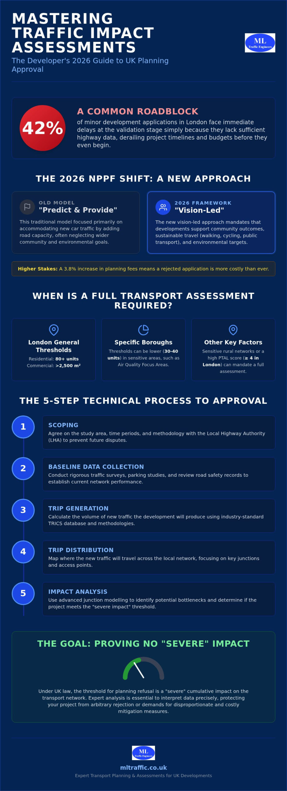
    Did you know that 42% of minor development applications in London face immediate delays at the validation stage simply because they lack sufficient highway data? For developers across the UK, securing a traffic impact assessment for new developments has become a high-stakes hurdle where technical precision is a functional necessity. You’re likely all too familiar with the unpredictable delays from local highway authorities and the soaring costs of unplanned mitigation measures that can derail a project’s budget before it even begins.

    It’s frustrating when regulatory confusion between Transport Statements and full Assessments stalls your progress. This guide provides a clear path to planning approval by mastering the complexities of the 2026 transport planning landscape. We’ll examine the shift toward “vision-led” outcomes in the latest NPPF guidelines and show you how to implement proportionate, cost-effective mitigation strategies. From navigating the recent 3.8% planning fee increase to understanding specific regional thresholds, this comprehensive manual ensures your development remains compliant, reliable, and ready for execution.

    Key Takeaways

    • Establish a clear project scope through early Highway Authority engagement to prevent methodology disputes and validation delays.
    • Identify the specific technical thresholds and regional regulations that determine when you must provide a traffic impact assessment for new developments.
    • Transition from traditional “predict and provide” models to the latest vision-led planning frameworks mandated by the revised 2026 NPPF.
    • Secure planning approval by implementing proportionate mitigation strategies that align with your project’s actual transport footprint.
    • Streamline the planning lifecycle from inception to completion by utilizing expert Transport Assessments and professional data collection.

    Understanding Traffic Impact Assessments in the UK Planning System

    A traffic impact assessment for new developments is a technical study that evaluates how a proposed project will interact with the existing transport network. It serves as a critical bridge between architectural vision and infrastructure reality. Rooted in the discipline of Traffic engineering, these assessments provide Local Highway Authorities (LHAs) with the necessary data to ensure road safety and network efficiency. While the industry often uses the term “Traffic Impact Assessment” (TIA) as a general descriptor, in the UK planning system, it specifically refers to the technical analysis that underpins a formal Transport Statement or a full Transport Assessment.

    In 2026, the regulatory environment has shifted significantly. The revised National Planning Policy Framework (NPPF) now prioritizes a vision-led approach over the traditional “predict and provide” model. This means your assessment must demonstrate how a development supports specific community outcomes and sustainable travel rather than just adding road capacity for cars. With planning fees in England having increased by 3.8% as of April 2026, the financial risk of a rejected application is higher than ever. Precision in your initial submission is a functional necessity to avoid the costs of rework and delays.

    The Purpose of a TIA: Beyond Simple Congestion

    Assessments don’t just look at traffic jams. They evaluate road safety and accessibility for all transport modes, including pedestrians, cyclists, and public transport users. LHAs use these reports to gauge the cumulative impact of several developments within a single area, ensuring that the local infrastructure can handle the combined pressure of multiple projects. Under UK law, the threshold for planning refusal is a “severe” impact on the transport network. Defining what constitutes “severe” requires professional precision and expert interpretation of data to protect your project from arbitrary rejection or disproportionate mitigation demands.

    Maintaining this standard of safety often involves coordination with external services. For instance, in regions like West Yorkshire, PL Mobile Tyres provides critical 24/7 roadside assistance, ensuring that tyre-related incidents do not cause the “severe” network impacts that planners work so hard to avoid.

    When is a TIA Legally Required?

    Requirements for a traffic impact assessment for new developments vary based on scale and location. In London, a full Transport Assessment is typically required for residential sites with 80 or more units or commercial spaces exceeding 2,500 square metres. However, some boroughs have lowered these thresholds to 30 or 40 units, particularly in Air Quality Focus Areas. Even small developments may require a full study if the local network is sensitive or located in a rural area with limited access. Factors like a site’s Public Transport Accessibility Level (PTAL) score also dictate the scope of the study. Sites with a PTAL score of 4 or higher in London are generally mandated to be car-free, which fundamentally changes the methodology of the assessment.

    The 5-Step Technical Process of a Traffic Impact Assessment

    Conducting a traffic impact assessment for new developments requires a methodical approach to ensure regulatory approval. The 5-Step Technical Process begins long before any data is collected on-site. By following a structured sequence, developers can mitigate the risk of local highway authority objections and avoid costly last-minute redesigns. Precision is a functional necessity at every stage to reduce logistical and regulatory pressures.

    • Scoping: You must first agree on the study area, time periods, and assessment methodology with the Local Highway Authority. This prevents fundamental disagreements later in the planning lifecycle.
    • Baseline Data Collection: Our team conducts rigorous Traffic Surveys and parking surveys to establish the current network performance. We also review existing road safety records to identify any pre-existing issues.
    • Trip Generation: We calculate the volume of new traffic the development will produce using industry-standard databases.
    • Trip Distribution: This stage maps where that new traffic will travel across the local network, focusing on key junctions and access points.
    • Impact Analysis: Using advanced junction modelling, we identify potential bottlenecks. This stage is critical for determining if the project meets the “severe impact” threshold discussed previously.

    Utilising the TRICS Database for Accurate Predictions

    The TRICS database is the national standard for trip generation analysis in the UK. It allows us to predict traffic volumes by comparing your project with data from thousands of established sites across the country. Selecting comparable sites is a high-stakes task that requires technical authority. If the chosen data points don’t align with your development’s specific land use or location, the highway authority will likely reject the findings. We ensure your submission is defensible by filtering for precise variables like site size, regional context, and transport accessibility.

    Swept Path Analysis: Proving Site Feasibility

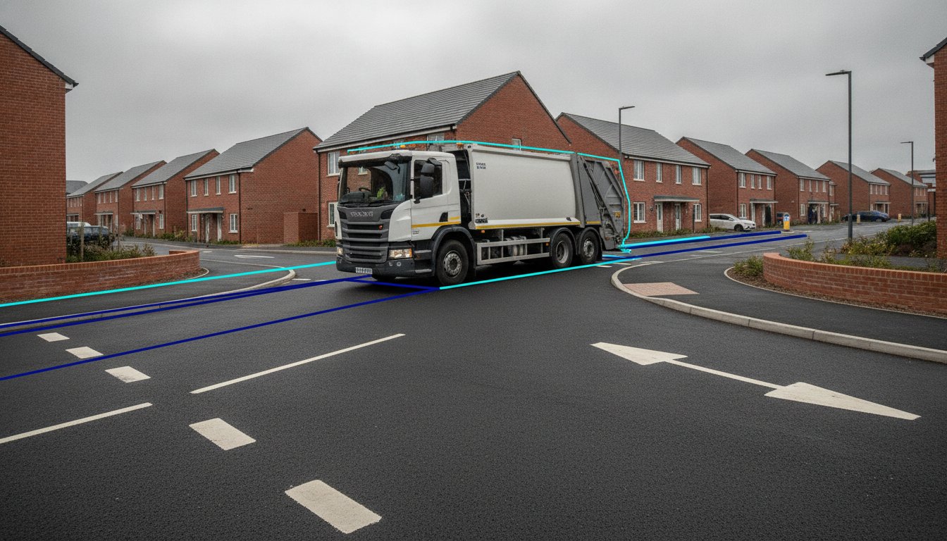
    A successful traffic impact assessment for new developments must prove that the physical site layout is functional. Swept Path Analysis uses AutoTURN software to simulate the movement of large vehicles, such as refuse trucks and fire tenders, through your proposed roads. This technical simulation prevents the logistical pressure of discovering that a vehicle cannot navigate a turn after construction has begun. By identifying these issues during the assessment phase, we help you avoid expensive post-submission redesigns. Ensuring that emergency services and delivery vehicles have unhindered access is a non-negotiable foundation of safety-conscious planning.

    Transport Statement vs. Assessment: Which One Do You Need?

    Determining the appropriate depth of reporting is the first strategic decision in your planning application. A misstep here causes immediate friction with the Local Highway Authority and can lead to unnecessary expenditure. The distinction between a Transport Statement and a full Assessment is primarily defined by the scale of the project and its anticipated trip generation. Selecting the wrong report type often results in the validation stage delays that currently affect 42% of minor development applications in London as of August 2026.

    In the capital, a London-specific Transport Assessment follows stricter criteria set by individual boroughs and the London Plan. These requirements directly impact project timelines, as the level of data scrutiny is significantly higher than in other regions. Early engagement during the pre-application stage is the only way to confirm which report you need. We manage this dialogue for you to ensure the scope is proportionate to your project’s impact, reducing logistical pressure from the start.

    Criteria for a Transport Statement

    A Transport Statement (TS) is a concise report designed for smaller developments with limited transport implications. Typically, this applies to residential projects between 50 and 80 dwellings, though some local authorities set lower thresholds. The TS focuses on immediate site matters: safe access, adequate parking provision, and links to sustainable travel networks. It is often the most cost-effective route for SMEs because it avoids the complex junction modelling required for larger schemes. Precision remains vital; even a shorter statement must satisfy the highway authority’s safety standards to avoid a recommendation for refusal.

    When a Full Transport Assessment is Mandatory

    Developments exceeding 80 residential units or significant commercial floor space require a full Transport Assessment (TA). This is a comprehensive traffic impact assessment for new developments that explores the cumulative effect on the wider transport network. A TA demands multi-modal analysis, evaluating how the project supports cycling, walking, and public transport integration. In 2026, any TA must be accompanied by a Travel Plan. This supporting document outlines long-term strategies to reduce car dependency and promote sustainable transport. Failing to include a robust Travel Plan is a common reason for application deferral under current NPPF guidelines. We ensure your TA includes all necessary technical data to withstand rigorous scrutiny from highway officers.

    Traffic Impact Assessment: 2026 Developer’s Guide

    Mitigation Strategies and Section 278 Agreements

    Identifying potential bottlenecks in your traffic impact assessment for new developments is only half the battle. The subsequent stage involves defining “proportionate mitigation.” This principle ensures that you only pay for the infrastructure improvements directly necessitated by your project’s impact. Under the 2026 vision-led NPPF framework, the focus has shifted from simply adding road capacity to creating sustainable, safe environments. This shift allows developers to propose a mix of physical and soft mitigation measures that satisfy the Local Highway Authority (LHA) while protecting project margins.

    Physical mitigation involves tangible changes to the road network, such as installing a new roundabout or widening a junction. These works typically fall under a Section 278 (S278) agreement. Developers must account for the high costs associated with these agreements, including technical approval fees and performance bonds. In regions like Worcestershire, technical approval and inspection fees as of June 2026 reach 8% to 10% of the scheme value. A major variable often overlooked is utility diversions, which can constitute 30% to 50% of the total cost for medium-scale schemes. Soft mitigation, conversely, focuses on behavioral changes, often managed through Section 106 (S106) financial contributions to wider transport infrastructure or the implementation of a Travel Plan.

    Negotiating with Local Highway Authorities

    Securing a fair outcome requires professional representation in LHA meetings. Local authorities often request extensive mitigation that exceeds the actual requirements of the development. Our team uses technical evidence from the assessment phase to challenge unreasonable requests. We ensure that any suggested works are strictly necessary and directly related to your site. A well-scoped TIA can limit a developer’s S106 financial liability by proving that specific off-site infrastructure upgrades are not directly necessitated by the proposed scheme. This technical authority reduces regulatory pressure and prevents budget creep.

    Travel Plans: A Tool for Reducing Physical Mitigation

    Modern planning policy prioritizes sustainable travel over road construction. Travel Plans are strategic documents that promote walking, cycling, and public transport use to reduce the total number of vehicle trips generated by a site. By demonstrating a credible reduction in car use, you can often negotiate a decrease in the required physical road improvements. This is particularly effective for Workplace Travel Plans, where employer-led initiatives like car-sharing or cycle-to-work schemes significantly lower peak-hour traffic. Integrating these “soft” measures into your development strategy is a cost-effective way to achieve compliance without the heavy engineering costs of S278 works. If you need to navigate these complex negotiations, view our full range of transport planning services to see how we can assist.

    Securing Approval: Why Expert Transport Planning Matters

    Attempting a DIY traffic impact assessment for new developments is a high-stakes strategy that often leads to planning refusal. Inaccurate baseline data or flawed trip generation models provide Local Highway Authorities (LHAs) with immediate grounds for objection. When technical data is scrutinized by planning officers, even minor discrepancies in survey methodology can invalidate an entire submission. Precision is a functional necessity in this environment to protect your investment and maintain your project timeline.

    The fast-moving nature of infrastructure development requires a partner with a sense of readiness and urgency. Our team remains constantly available to address sudden requests for additional data or technical clarifications from the LHA. This rapid response capability is a hallmark of our service promise. It ensures that your application doesn’t stall due to administrative bottlenecks or technical queries. By positioning ourselves as a comprehensive partner rather than a simple data provider, we navigate the intricate regional regulations so you don’t have to.

    The ML Traffic Advantage: Precision and Reliability

    Our technical lexicon and professional reporting speak the language of local planning officers. We conduct specialized Traffic Surveys and parking surveys that provide a robust evidence base for your application. This data-driven precision allows us to defend your development against unreasonable mitigation requests. We take pride in our adherence to standards, utilizing our expertise in TRICS database analysis and Swept Path Analysis to deliver tailored reports. This all-encompassing service minimizes the risk of validation delays and strengthens your path to approval.

    Next Steps for Your Development

    Engaging a transport consultant early in the concept stage is the most effective way to streamline the planning process. Early involvement allows us to identify potential transport constraints before they become costly obstacles. We provide bespoke documentation that aligns with your specific site requirements and local authority expectations. To secure expert support for your next project, you can contact ML Traffic Engineers for a comprehensive transport planning review. Our team is ready to provide the technical precision and reliable support your development needs to succeed.

    Securing Your Development’s Future with Technical Precision

    The 2026 planning landscape demands a shift from traditional traffic forecasting to outcome-focused, vision-led strategies. Successfully navigating a traffic impact assessment for new developments requires more than just data collection. It necessitates a deep understanding of regional thresholds and the ability to negotiate proportionate mitigation through formal excellence. By establishing a robust technical baseline early in the concept stage, you protect your project from the validation delays and unpredictable costs that frequently stall UK developments.

    Precision is a functional necessity in transport planning. ML Traffic Engineers provides full project lifecycle management, from initial surveys to final submission, ensuring your reporting speaks the language of local planning officers. Our expertise in TRICS database analysis and junction modelling, combined with specialized knowledge in S278 and S38 highway design, reduces the regulatory pressure on your team. Secure your planning approval with ML Traffic Engineers’ expert transport reports. We remain ready to provide the professional, safety-conscious support required to move your project forward with confidence.

    Frequently Asked Questions

    How much does a Traffic Impact Assessment cost for a new development?

    Costs vary based on project scale, site complexity, and the specific requirements of the Local Highway Authority. A residential scheme with 100 units requires more intensive junction modelling than a small commercial unit. Factors like utility diversion investigations and technical approval fees also influence the total budget. This ensures your budget accounts for all necessary technical surveys and regulatory fees. Requesting a project-specific quote is the most reliable approach.

    How long does it take to complete a Transport Assessment in 2026?

    A typical assessment takes between four to eight weeks to complete, depending on the availability of baseline data. This timeline includes the initial scoping with the highway authority, on-site traffic counts, and technical analysis. Complex projects requiring extensive junction modelling or multi-modal studies may take longer. Early engagement is essential to ensure the final report is ready for the validation stage of your planning application. Precision in timing helps avoid unnecessary logistical pressure.

    Can I get planning permission if the TIA shows a significant increase in traffic?

    Yes, provided the impact is not deemed severe under the National Planning Policy Framework and suitable mitigation is proposed. A traffic impact assessment for new developments identifies these increases so that developers can implement improvements like junction upgrades or Travel Plan initiatives. If the proposed mitigation effectively manages the additional volume, the Local Highway Authority is more likely to support the application. Technical precision in your report is a functional necessity here.

    What is the difference between a Traffic Impact Assessment and a Transport Statement?

    The primary difference lies in the scale of the development and the depth of the required technical analysis. A Transport Statement is a concise report for smaller projects with limited transport implications. A full Assessment is a comprehensive study for larger developments that includes detailed junction modelling. The Local Highway Authority typically sets specific thresholds to determine which report type is necessary for a traffic impact assessment for new developments.

    What data is required for a parking survey in a UK planning application?

    Parking surveys must capture the existing parking demand and capacity within a defined area, usually following the Lambeth Methodology in urban settings. Data includes the total number of available spaces, current occupancy levels during peak hours, and any existing parking restrictions. This information proves that the development’s parking provision is adequate and won’t lead to overspill on the local road network. It’s a non-negotiable foundation for safety-conscious planning and regulatory compliance.

    Do I need a Travel Plan if I already have a Traffic Impact Assessment?

    A Travel Plan is almost always required as a supporting document for a full Transport Assessment in 2026. While the assessment identifies the physical impact of traffic, the Travel Plan outlines long-term strategies to encourage sustainable travel. These documents work together to show how the development will reduce car dependency and align with the latest vision-led NPPF guidelines. Integrating both documents demonstrates a commitment to professional integrity and civic responsibility.

    What happens if the Highway Authority objects to my TIA results?

    If an objection occurs, you must enter technical negotiations to address the authority’s concerns. This often involves providing additional data, refining modelling parameters, or proposing more robust mitigation measures. Professional representation is a functional necessity during these meetings to challenge unreasonable requests with technical evidence. Resolving these objections through expert reporting is critical to securing planning approval and avoiding a formal refusal. Our team remains ready to assist with these urgent requirements.

    Is a Swept Path Analysis always required for residential developments?

    Swept Path Analysis is essential for any development where large vehicles, such as refuse trucks or fire tenders, must navigate the site. While not always mandatory for very small infill projects, most Local Highway Authorities require it to prove site feasibility. This technical simulation ensures that emergency services have unhindered access and prevents the logistical pressure of expensive post-construction redesigns. It remains a hallmark of reliable, safety-conscious site planning that adheres to strict industry benchmarks.

    Michael Lee

    Article by

    Michael Lee

    Transport planner with over 35 years' experience.

    Disclaimer

    The content on mltraffic.co.uk, including all technical articles, guides, and resources, is provided for general informational and educational purposes only. It is not intended to constitute professional advice in traffic engineering, transportation planning, development approvals, or any other technical or legal field.
    While ML Traffic Engineers makes every reasonable effort to ensure the accuracy, completeness, and timeliness of the information published, we do not provide any warranties or representations (express or implied) regarding its reliability, suitability, or availability for any particular purpose. Any reliance you place on the content is strictly at your own risk.
    In no event shall ML Traffic Engineers, its directors, employees, authors, or affiliates be liable for any direct, indirect, incidental, special, consequential, or punitive damages (including, without limitation, loss of profits, data, or business opportunities) arising out of or in connection with the use of, or inability to use, any information provided on this website.
    The articles and guides on this site are not a substitute for engaging a qualified, professional traffic engineer to assess your specific project requirements. For tailored advice, compliance assessments, or traffic engineering services, please contact a competent professional.
    This disclaimer may be updated from time to time without notice. By accessing or using this website, you agree to be bound by the most current version of this disclaimer.
  • Transport Engineering Consultants London: Navigating Planning Success in 2026

    Transport Engineering Consultants London: Navigating Planning Success in 2026

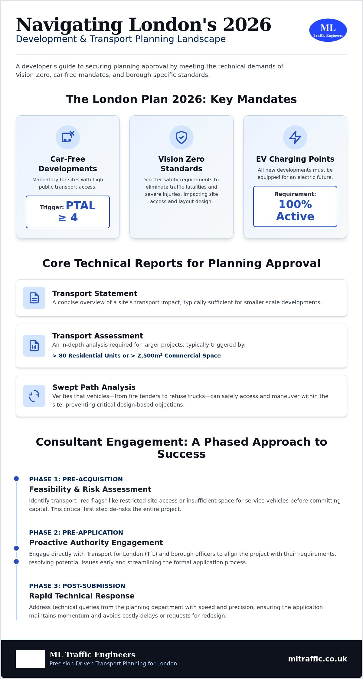
    In 2026, a single error in a swept path analysis or a misunderstood PTAL rating can derail a multi-million pound London development before the first brick is even laid. You’ve likely felt the frustration of planning delays caused by unexpected transport objections or the shifting requirements of individual London boroughs. To manage these risks, developers rely on transport engineering consultants london who understand that technical precision is a functional necessity. With the London Plan 2026 now mandating car-free developments for sites with a PTAL score of 4 or higher, the margin for error has disappeared.

    This guide explains how expert technical reporting helps you secure rapid planning approval without transport-related hitches. You’ll learn how to avoid the unexpected costs of redesigns by utilizing accurate Parking Surveys and Transport Statements from the outset. We’ll detail how to align your project with the latest 2026 mandates, including the requirement for 100% active electric vehicle charging points and stricter Vision Zero safety standards. Discover how to turn rigorous technical data into a clear path for development success.

    Key Takeaways

    • Understand how London’s 2026 Vision Zero and sustainability mandates shift the technical requirements for planning approval.
    • Learn how transport engineering consultants london use Swept Path Analysis and Transport Statements to prove development viability to local authorities.
    • Navigate complex London-specific metrics like PTAL and the Lambeth Methodology to ensure parking allocations meet strict borough standards.
    • Identify the critical technical proficiencies and software expertise required to evaluate a transport consultancy for high-stakes urban projects.
    • Discover how precision-driven reporting and rapid response times reduce the risk of costly redesigns and planning objections.

    The Role of Transport Engineering Consultants in London’s 2026 Planning Landscape

    In the high-stakes environment of London property development, transport engineering consultants london serve as the technical backbone of a successful planning application. They manage the complex transportation planning process to ensure that proposed sites don’t just look good on paper but function safely and efficiently in reality. By 2026, the shift toward “Active Travel” and the strict “Vision Zero” safety standards has made these experts indispensable. They provide the rigorous data required to satisfy the London Plan 2026 mandates, such as the requirement for car-free developments in areas with a PTAL score of 4 or higher.

    To better understand how these experts shape the urban environment, watch this overview of the profession:

    When to Engage a Consultant in the Project Lifecycle

    Early engagement is a functional necessity for maintaining project timelines. During pre-acquisition feasibility, consultants identify transport “red flags” like restricted site access or insufficient space for fire tenders before you commit capital. In the pre-application stage, they engage with TfL and borough officers to resolve potential issues early. Post-submission, they provide the rapid response capabilities needed to address technical queries from the planning department, ensuring the project moves from inception to completion without hitches.

    Key Regulatory Bodies for London Developments

    Navigating London requires managing overlapping jurisdictions. Transport for London (TfL) maintains oversight on red routes and larger developments, while the 33 individual boroughs enforce their own specific parking and access standards. While the National Planning Policy Framework (NPPF) provides the baseline for 2026, the London Plan imposes much stricter local requirements. Your consultant ensures your technical documentation, such as a Transport Assessment, meets these multi-layered criteria while accounting for borough-specific parking standards and carbon reduction targets.

    Core Technical Services: From Transport Statements to Swept Path Analysis

    Securing planning approval in London requires more than a vision; it demands raw data and technical validation. Expert transport engineering consultants london provide the specific documentation needed to satisfy both Transport for London (TfL) and individual borough requirements. Choosing the right report is your first critical decision. For smaller developments, a Transport Statement provides a concise overview of the site’s impact. However, projects exceeding 80 residential units or 2,500 square meters of commercial space typically trigger a full Transport Assessment. In 2026, even smaller sites of 30 to 40 units in Air Quality Focus Areas may require these deeper technical dives.

    Precision Reporting for Planning Success

    A robust technical report does not just list facts; it builds a case for your development. We utilize the TRICS database to provide accurate trip generation forecasting, ensuring your site’s projected impact is based on verified industry data. These reports must align with the standards set by the Chartered Institution of Highways & Transportation to ensure they hold up under scrutiny from local highway authorities. If you need to justify your design choices, our technical service offerings provide the necessary evidence to overcome planning objections.

    Traffic and Parking Surveys provide the foundation for these reports. By 2026, the London Plan mandates 100% active electric vehicle charging for any permitted spaces, making precise parking data essential. We collect real-time data to justify your site design, ensuring your parking allocation aligns with strict borough standards while promoting sustainable transport through comprehensive Travel Plans. This data-led approach ensures your project meets environmental targets without compromising functionality.

    The Importance of Swept Path Analysis (SPA)

    Swept Path Analysis is a technical tool used to demonstrate vehicle access feasibility within site designs through computer-simulated movements. Using industry-standard AutoTURN software, we prove that your site can safely accommodate essential vehicles. This precision is a functional necessity to prevent costly construction errors or redesigns after a failed access test. Transport engineering consultants london use these simulations to guarantee that your site layout works in practice, not just in theory.

    Our simulations are specifically calibrated for London’s unique requirements. We use precise templates for:

    • London Fire Brigade tenders to ensure emergency access compliance.
    • Standard refuse lorries for municipal waste collection.
    • Delivery vans and petrol tankers for commercial loading requirements.

    By proving maneuverability at the design stage, we remove the logistical pressures that often lead to planning delays.

    London’s transport planning environment is a complex patchwork of overlapping jurisdictions and strict technical benchmarks. Developers must satisfy the requirements of both Transport for London (TfL) and the specific local highway authority of the borough. In 2026, the regulatory pressure is higher than ever. Success depends on a deep understanding of regional regulations and the ability to produce documentation that stands up to rigorous scrutiny. Expert transport engineering consultants london act as the vital bridge between your commercial goals and these intricate public standards.

    The PTAL Rating System Explained

    The Public Transport Accessibility Level (PTAL) is the primary metric used to dictate your site’s parking allowance. Under the London Plan 2026, any development in an area with a PTAL score of 4 or higher must be car-free. If your project sits in a high-accessibility zone, your planning application will likely fail if it includes private residential parking. For sites with low PTAL ratings of 1 or 2, the challenge shifts to proving that the development won’t overwhelm local infrastructure. We utilize comprehensive Travel Plans to offset car dependency in these areas, demonstrating a clear commitment to sustainable transport targets.

    Central London developments face even stricter “Zero Parking” policies. In these high-stakes environments, we focus on technical data for cycle storage and delivery management. We also assess the impact on the Strategic Road Network (SRN) and the Transport for London Road Network (TLRN). Protecting these arterial routes is a functional necessity for TfL. Our reports ensure your site access doesn’t compromise the safety or efficiency of London’s primary traffic flows.

    Parking Survey Methodologies in 2026

    Proving that a development won’t create “parking stress” requires a specialized technical approach. The Lambeth Methodology remains the gold standard for parking surveys across most London boroughs. It isn’t just about counting cars; it’s a rigorous assessment of street capacity within a set radius of your site. We conduct overnight surveys to capture peak residential parking demand, ensuring the data is accurate and beyond reproach. Transport engineering consultants london use this raw data to justify your site design to skeptical planning officers.

    Accuracy in these surveys prevents planning refusal based on the cumulative impact of nearby developments. We analyze the surrounding streetscape to ensure that new residents or commercial tenants don’t exhaust local parking resources. This level of technical precision is non-negotiable for securing approval. By providing clear, data-driven evidence of parking capacity, we reduce the risk of costly delays and objections from local residents and highway authorities.

    Transport Engineering Consultants London: Navigating Planning Success in 2026

    How to Evaluate a London Transport Consultancy for Your Project

    Selecting a partner for your development is a decision that directly impacts your project timeline and capital expenditure. In 2026, you don’t just need a designer; you need transport engineering consultants london who operate with technical authority and a sense of readiness. You should prioritize a firm that offers a fully managed service. This ensures that a single expert team manages the entire process from the initial parking survey to the final technical report, preventing the data gaps that often occur when using multiple subcontractors.

    To ensure your project remains on track, follow these four evaluation steps:

    • Verify Borough Track Record: Confirm they’ve successfully secured approvals in the specific London borough where your site is located.
    • Check Software Proficiency: Ensure they use industry-standard tools like AutoTURN for swept path analysis, TRICS for trip forecasting, and Junctions 10 for capacity modeling.
    • Assess Response Time: Planning deadlines don’t move; you need a consultant who demonstrates constant accessibility and can handle urgent technical queries from highway officers.
    • Confirm Engineering Depth: Verify they can provide data-led justifications for access issues rather than just surface-level policy advice.

    Technical Competency vs. General Design

    There’s a critical difference between a general transport planner and a transport engineer. While a planner understands policy, an engineer solves complex access and safety issues through technical precision. For high-stakes London developments, you need an engineer who can use data to defend your site design. Finding these specialized professionals is increasingly competitive, which is why many top-tier firms partner with TrustTech Recruitment, a tech recruitment agency UK, to secure the niche technical talent required for 2026 planning standards. Before hiring, ask about their relationship with local highway officers. A consultant who speaks the technical language of the authority can often resolve potential objections before they become formal planning hurdles.

    The Importance of Local Knowledge

    Local knowledge is a functional necessity in London’s fragmented regulatory environment. A consultant familiar with the specific requirements of Tower Hamlets or Southwark will understand borough-specific quirks, such as unique cycle storage standards or local air quality focus areas, that a national firm might overlook. Establishing a local rapport can significantly expedite the s278 agreement process by ensuring your highway works designs align with the borough’s preferred specifications from the first draft. If you require a partner that understands these intricate regional regulations, explore how our transport planning services can secure your project’s success.

    ML Traffic Engineers: Precision-Driven Transport Planning for London

    Success in London’s infrastructure sector requires a partner that mirrors the city’s own round-the-clock momentum. At ML Traffic Engineers, we provide the technical authority and rapid response capabilities that developers need to navigate the high-stakes planning environment of 2026. As established transport engineering consultants london, we prioritize precision as a functional necessity. We understand that a single day’s delay in planning can impact your bottom line. That’s why we maintain a sense of readiness and constant availability to address technical objections as they arise.

    Our specialized focus centers on the core technical documents that drive planning success. We deliver compliance-focused Transport Statements and detailed Swept Path Analysis tailored to the specific vehicle templates required by London boroughs. By managing the full project lifecycle from initial surveys to final approval, we reduce the regulatory pressure on your team. Our reports don’t just present data; they provide a robust defense of your site’s viability based on industry benchmarks and legislative requirements.

    Why Developers Trust ML Traffic

    Developers choose us because we take immense pride in our adherence to standards and our precision-first approach. We’ve built a proven track record of securing planning approval across all 33 London boroughs, from the car-free mandates of the City to the complex parking requirements of the outer boroughs. As expert transport engineering consultants london, our team recently resolved a critical access issue for a constrained urban site in East London. By using advanced simulation software, we proved that fire tenders could safely maneuver within the tight site boundaries, preventing a total redesign of the ground floor layout. This level of technical proficiency ensures your project moves from inception to completion without hitches.

    Get Started with Your London Project

    Securing expert advice early in your project lifecycle is the best way to identify transport “red flags.” When you request a quote for a technical report or parking survey, you’ll receive a clear, functional proposal that outlines the scope of work. During our initial site assessment, we evaluate the existing transport infrastructure and identify potential borough-specific quirks that could impact your application. We prioritize clarity and the rapid delivery of information, ensuring you have the data you need when you need it.

    Don’t let transport objections stall your development. Contact ML Traffic Engineers for expert transport planning advice and discover how our precision-driven reporting can secure your planning success in 2026.

    Securing Your Planning Approval in 2026

    Navigating London’s 2026 planning landscape requires more than just a vision; it demands technical authority and a commitment to precision. By utilizing expert transport engineering consultants london, you ensure that your project meets the strict Vision Zero safety standards and borough-specific parking requirements. Precision data, such as expert Swept Path Analysis using AutoTURN, provides the objective evidence needed to satisfy local highway authorities and avoid costly redesigns. Technical excellence isn’t just a preference; it’s a functional necessity for site viability.

    Since our founding in 2014, ML Traffic Engineers has focused on technical precision to help developers manage full project lifecycles from inception to completion. We specialize in London Borough planning requirements, ensuring your documentation is compliant and ready for immediate review. Our team understands the intricate regional regulations so that you don’t have to. Don’t let regulatory hurdles delay your progress. Request a technical quote for your London transport planning needs today. We’re ready to provide the reliable, data-driven support your development deserves.

    Frequently Asked Questions

    What does a transport engineering consultant actually do for a planning application?

    A consultant provides the technical documentation required to prove your development is safe and viable. They produce reports such as Transport Statements and Assessments that analyze site access, traffic impact, and parking compliance. By translating your commercial goals into technical language, they help you navigate the requirements of TfL and individual London boroughs to avoid planning objections.

    When is a Transport Statement required instead of a full Transport Assessment in London?

    The choice depends on the scale of your development and its potential impact on the road network. In 2026, the standard trigger for a full Transport Assessment is 80 or more residential units or commercial space exceeding 2,500 square meters. Smaller projects usually only require a Transport Statement, though sites in Sensitive Areas like Air Quality Focus Areas may face stricter requirements.

    How much does it cost to hire a transport consultant for a London project in 2026?

    Fees for transport consultancy are based on the specific scope of your project and the complexity of the required reports. A simple Swept Path Analysis will have a different cost structure than a full Transport Assessment that includes extensive traffic surveys. You should request a tailored quote to ensure the service matches your site’s specific regulatory needs and borough standards.

    What is Swept Path Analysis and why does my architect need it?

    Swept Path Analysis is a technical simulation that proves vehicles can maneuver safely within your site layout. Architects need this data to confirm that essential vehicles, such as London Fire Brigade tenders and refuse lorries, can access the site without conflict. Providing this evidence during the design stage is a functional necessity to prevent costly redesigns after you submit your planning application.

    Can a transport consultant help me if my planning application was already refused?

    Yes, consultants specialize in resolving transport-related objections that lead to refusals. Transport engineering consultants london can analyze the council’s feedback and provide new technical data, such as an updated Parking Survey, to address specific concerns. This data-led approach provides the objective evidence needed to overcome objections and move your project toward approval through a resubmission or appeal.

    How long does it take to produce a Transport Statement for a London site?

    Production timelines typically range from two to four weeks depending on the complexity of the project. This timeframe accounts for initial site assessments, data collection, and the drafting of the technical report. We maintain a sense of urgency to ensure your documentation is ready for submission in line with your project’s critical planning deadlines.

    What is the TRICS database and why is it used in transport planning?

    TRICS is the national standard system for trip generation analysis used by transport engineering consultants london to forecast development impact. It provides verified data from similar existing sites to predict how much traffic your new project will create. Planning officers require this data because it offers an objective, industry-standard baseline for assessing whether the local road network can accommodate your proposal.

    Do I need a separate parking survey if I already have a transport assessment?

    Most London boroughs require a standalone parking survey even if you have a Transport Assessment. This is because authorities need granular data on “parking stress” within a specific radius of your site, usually following the Lambeth Methodology. A dedicated survey provides the raw evidence needed to prove that your parking allocation, or lack thereof in car-free zones, won’t negatively impact local residents.

    Michael Lee

    Article by

    Michael Lee

    Transport planner with over 35 years' experience.

    Disclaimer

    The content on mltraffic.co.uk, including all technical articles, guides, and resources, is provided for general informational and educational purposes only. It is not intended to constitute professional advice in traffic engineering, transportation planning, development approvals, or any other technical or legal field.
    While ML Traffic Engineers makes every reasonable effort to ensure the accuracy, completeness, and timeliness of the information published, we do not provide any warranties or representations (express or implied) regarding its reliability, suitability, or availability for any particular purpose. Any reliance you place on the content is strictly at your own risk.
    In no event shall ML Traffic Engineers, its directors, employees, authors, or affiliates be liable for any direct, indirect, incidental, special, consequential, or punitive damages (including, without limitation, loss of profits, data, or business opportunities) arising out of or in connection with the use of, or inability to use, any information provided on this website.
    The articles and guides on this site are not a substitute for engaging a qualified, professional traffic engineer to assess your specific project requirements. For tailored advice, compliance assessments, or traffic engineering services, please contact a competent professional.
    This disclaimer may be updated from time to time without notice. By accessing or using this website, you agree to be bound by the most current version of this disclaimer.

  • London Transport Statement: 2026 Strategic Guide

    London Transport Statement: 2026 Strategic Guide

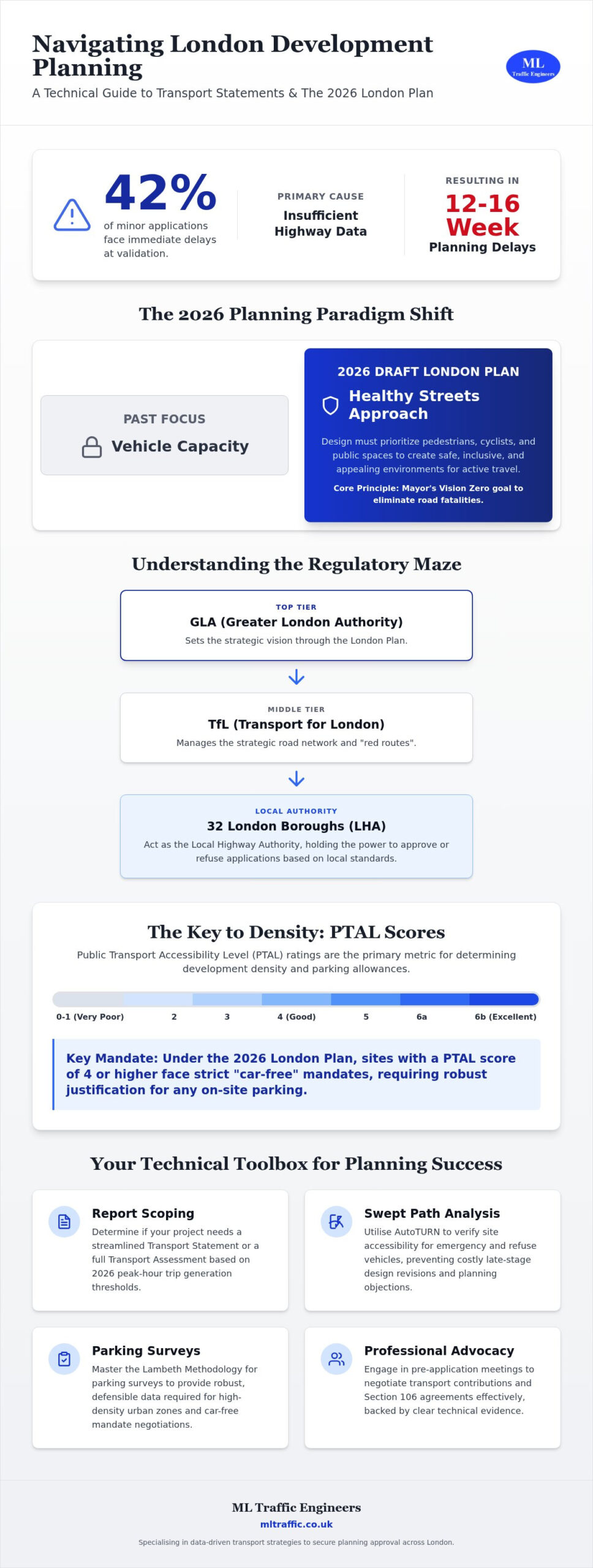
    Did you know that 42% of minor development applications in London face immediate delays at the validation stage because they lack sufficient highway data? In the current 2026 planning climate, submitting a transport statement for new developments london is no longer a mere formality. It’s a high-stakes technical negotiation. With the Draft London Plan 2026 now in consultation, the friction between Transport for London (TfL) requirements and local borough mandates has never been more complex.

    We recognise that managing conflicting PTAL ratings and car-free mandates often feels like an expensive hurdle. You’re likely focused on avoiding the 12 to 16 week delays that follow a transport objection. This guide provides the strategic insight you need to secure planning approval with technical precision while optimising your site capacity. We’ll examine the latest 2026 thresholds, the shift toward Healthy Streets metrics, and how to use data-driven design to bypass common planning bottlenecks.

    Key Takeaways

    • Understand the regulatory hierarchy between the GLA, TfL, and local boroughs to ensure your project aligns with the 2026 London Plan pillars.
    • Identify whether your project requires a full Assessment or a streamlined transport statement for new developments london based on 2026 peak-hour movement thresholds.
    • Utilise technical tools like AutoTURN Swept Path Analysis to verify site accessibility for emergency and refuse vehicles, which prevents costly design revisions.
    • Master the Lambeth Methodology for parking surveys to provide the robust data required for high-density urban zones and car-free mandates.
    • Learn how professional advocacy in pre-application meetings helps you negotiate transport contributions and Section 106 agreements more effectively.

    Defining London Transport Planning for New Developments

    While most Londoners view transport planning through the lens of a Transport for London (TfL) journey app, developers face a much stricter statutory reality. Statutory transport planning isn’t about finding the quickest route; it’s about proving that a new building won’t break the existing network. In 2026, a transport statement for new developments london acts as the primary gatekeeper for planning approval. Without a robust technical justification for site access and trip generation, even the most architecturally sound projects fail at the validation stage.

    The current Draft London Plan 2026 shifts the focus from vehicle capacity to the “Healthy Streets” approach. This framework uses ten specific indicators to ensure public spaces are safe, inclusive, and appealing for active travel. For developers, this means site design must prioritise pedestrians and cyclists over private car storage. Successful planning applications now use transport data to facilitate higher urban density, proving that sustainable infrastructure can support more residents without increasing local congestion.

    To better understand how these technical requirements influence your application, watch this helpful video:

    The Core Objectives of a Development Transport Strategy

    Safe, multi-modal access is the foundation of any modern development. Your strategy must achieve several critical goals to pass borough scrutiny:

    • Demonstrate safe, accessible entry points for residents, visitors, and commercial deliveries.
    • Mitigate the cumulative impact of new trips on the local London road network using up-to-date TRICS data.
    • Align site layouts with sustainable transport goals to reduce reliance on private vehicles.

    Under the Mayor’s Vision Zero goal, 2026 site layouts must eliminate all potential conflict points between vulnerable road users and heavy service vehicles to ensure zero fatal incidents.

    Early-Stage Integration: Why Timing Matters

    Retrofitting access solutions after a design is finalised is a costly mistake. Early-stage transport feasibility studies identify constraints before they become planning objections. This data directly influences internal site layouts and unit capacity, ensuring you don’t lose valuable square footage to inefficient vehicle tracking. Commissioning a transport statement for new developments london during the pre-planning phase allows us to identify these risks early. Explore our project types to see how early-stage integration secures smoother approvals across diverse London sites.

    The Regulatory Framework: TfL, Boroughs, and the London Plan

    Success in London planning requires a clear understanding of the three-tier regulatory system. The Greater London Authority (GLA) sets the strategic vision through the London Plan, while Transport for London (TfL) manages the strategic road network and red routes. However, the 32 London Boroughs act as the Local Highway Authority (LHA) for most development sites. This hierarchy creates a complex environment where national standards, such as the UK Government Planning Practice Guidance, are filtered through specific regional mandates. The LHA holds the power to recommend refusal if your proposal doesn’t meet local safety or capacity standards.

    The 2026 London Plan draft, published in July 2026, reinforces the “car-free” mandate for areas with high public transport accessibility. Developers often face tension between these strategic goals and the practical parking needs of local residents. While TfL pushes for zero on-site parking in most zones, some boroughs maintain specific requirements for blue-badge holders and essential service vehicles. A technical transport statement for new developments london must bridge this gap, justifying site-specific deviations through robust data and professional advocacy.

    PTAL Scores: The DNA of London Development Density

    PTAL (Public Transport Accessibility Level) ratings from 0 to 6b are the primary metric for determining development density and parking allowances. In 2026, any site with a PTAL score of 4 or higher is typically mandated as “car-free,” with the exception of essential disabled parking. This “car-capped” status is a non-negotiable pillar of the current planning framework. Because transport networks evolve, you must verify your PTAL scores against the latest 2026 database to ensure your application uses current accessibility metrics. An inaccurate rating can lead to an immediate rejection of your parking strategy at the validation stage.

    Borough-Specific Nuances and Local Plans

    Local policies often supersede general London Plan guidance when specific urban constraints exist. For instance, high-density boroughs like Tower Hamlets enforce strict cycle parking ratios and delivery requirements that differ significantly from the suburban standards found in Richmond or Bromley. If you are working in East London, our guide on Transport Planning Consultants Tower Hamlets provides specific insights into these local variations. Understanding these nuances ensures your transport statement for new developments london addresses the exact concerns of the borough’s planning officers, reducing the risk of costly revisions.

    Essential Technical Reports: Statements vs. Assessments

    Choosing the correct technical report is a critical decision that determines your project’s timeline and budget. A transport statement for new developments london serves as a concise evaluation for projects with a limited impact on the local highway network. In contrast, a Transport Assessment is a comprehensive study required for major schemes that could significantly alter traffic patterns or public transport capacity. Both documents rely on precise baseline data collection to establish a “nil-detriment” position. This technical benchmark proves that your proposal won’t negatively affect the safety or capacity of the existing infrastructure.

    Establishing nil-detriment requires comparing the existing site usage against the proposed development’s impact using industry-standard TRICS data. If the new project generates fewer or equivalent peak-hour movements, we can argue that the development has a neutral impact. This technical advocacy is essential for securing approval in high-density areas where road capacity is already at its limit. We use these findings to justify site density while ensuring the project remains compliant with the latest 2026 safety standards.

    Report Thresholds: Which Documentation Do You Need?

    Report thresholds are generally determined by unit count, floor space, and predicted trip generation. In 2026, a full Transport Assessment is typically mandatory for residential developments of 80 or more units or commercial spaces exceeding 2,500 square metres. However, some boroughs have lowered these thresholds to 30 or 40 units in Air Quality Focus Areas. A robust Transport Statement London can often satisfy the Local Highway Authority for mid-sized projects. Providing high-quality data early can prevent the need for a more expensive and time-consuming full Assessment, keeping your planning application on track.

    The Anatomy of a 2026 London Travel Plan

    A 2026 London Travel Plan isn’t just a document; it’s a long-term commitment to sustainable movement. It must include SMART targets (Specific, Measurable, Achievable, Relevant, and Time-bound) to encourage walking, cycling, and public transport use. These plans are frequently tied to Section 106 transport obligations, meaning failure to meet targets can lead to financial penalties or monitoring fees. Boroughs now demand detailed strategies for active travel integration to align with the Mayor’s Healthy Streets indicators. For a deeper look at these requirements, see our London Travel Plans guide.

    Technical Precision: Swept Path Analysis and Survey Data

    Technical precision forms the backbone of a successful transport statement for new developments london. Without empirical data, your application rests on assumptions that planning officers will quickly challenge. We use advanced modelling and rigorous survey techniques to transform subjective design choices into objective, defensible facts. This approach doesn’t just satisfy regulatory requirements; it protects your project from the high costs of late-stage redesigns. By proving that your site can physically accommodate its required functions, you remove the primary grounds for highway objections.

    Data-driven advocacy allows us to justify “spare capacity” in the local street network. When residents object based on perceived congestion, we provide the hard numbers that demonstrate the network can handle the additional load. We focus on establishing a clear technical narrative that aligns with borough expectations while maximising your site’s operational potential. If you need technical certainty for your next project, contact ML Traffic Engineers UK for a comprehensive data assessment.

    Swept Path Analysis: Eliminating Design Risk

    Architects should integrate Swept Path Analysis (SPA) during the initial feasibility phase to avoid “landlocked” site layouts. Using AutoTURN software, we simulate the movements of standard London vehicle templates, including 12m refuse lorries and fire tenders. This ensures that essential service vehicles can enter, turn, and exit the site in forward gear, which is a non-negotiable safety standard for most boroughs. Proving this access early prevents the need to move structural columns or widen access gates after the design is locked. For a detailed breakdown of this process, read our AutoTURN Swept Path Analysis Guide.

    Data-Driven Advocacy: Parking and Traffic Surveys

    Addressing resident concerns about parking “overspill” requires the industry-standard Lambeth Methodology for parking surveys. This rigorous approach measures parking stress within a 200-metre walking distance of the site over two consecutive weekday nights. In 2026, these surveys must now account for increased EV charging dwell times, as longer stays at public charging points affect local parking availability. Accurate traffic data collection has also evolved, moving from manual counts to Automated Traffic Counts (ATC) to provide 24/7 reliability. This level of detail is essential for proving that your development won’t cause a “severe” impact under the National Planning Policy Framework (NPPF), a label that frequently leads to immediate planning refusal.

    London Transport Statement: 2026 Strategic Guide

    Securing Approval: The Path to Planning Success

    Securing planning permission in London’s competitive property market requires more than just submitting data. It’s about strategic negotiation and professional advocacy. While previous sections detailed the technical requirements of a transport statement for new developments london, this final stage focuses on turning that data into a formal approval. Planning officers at TfL and local boroughs deal with hundreds of applications. Your project needs a clear, technically sound narrative to move through the system without friction; additionally, ensuring the local community is well-informed through services like LeafletPro UK can be a vital part of your broader engagement strategy.

    Negotiation is a vital component of the approval path, particularly regarding Section 106 and Section 278 agreements. These legal frameworks dictate your financial contributions toward local infrastructure and the specific highway works you must fund. We advocate on your behalf to ensure that Community Infrastructure Levy (CIL) payments and transport contributions are proportionate to your project’s actual impact. Our technical authority allows us to challenge over-specified requirements, protecting your project’s viability while meeting all safety benchmarks.

    Navigating the Pre-Application Process

    We recommend engaging in pre-application meetings to identify potential “show-stoppers” before you commit to a formal submission. This early dialogue allows us to narrow the scope of required transport modelling, which saves you significant time and consultancy fees. By agreeing on the methodology and baseline data with the highway officer upfront, we reduce the risk of unexpected objections later. Learn more about what we do to secure these early wins for our clients.

    The ML Traffic Advantage: Precision and Compliance

    Our team manages the full project lifecycle, from initial site inception through to the final implementation of S278 and S38 highway designs. We specialise in solving complex access issues for constrained Central London sites where traditional solutions often fail. Whether you’re navigating car-free zone expansions or the latest 2026 PTAL threshold updates, our round-the-clock reliability ensures your project stays on schedule. We provide the technical precision required to meet strict highway design standards, ensuring that adopted roads and site access points are safe and compliant.

    Precision isn’t just a functional necessity; it’s your best defence against planning delays. By partnering with experts who understand the intricate regional regulations, you can focus on your development’s vision while we handle the regulatory pressure. We take pride in our adherence to industry benchmarks and our ability to deliver results in high-stakes environments.

    Contact ML Traffic Engineers for a London Transport Planning Quote to secure expert advocacy for your next development application.

    Optimising Your Development for 2026 Planning Success

    London’s planning environment demands technical excellence and strategic foresight. We’ve explored how accurate PTAL verification and the Healthy Streets approach define modern site capacity. Securing a transport statement for new developments london isn’t just about meeting a threshold; it’s about providing the technical justification that planning officers require to approve your vision. Technical precision in swept path analysis and parking surveys remains your strongest tool to bypass regulatory bottlenecks and secure your project’s timeline.

    Since 2014, we’ve specialised in navigating London Borough statutory requirements to deliver successful submissions. We manage the full project lifecycle from initial inception to complex S278 implementation, ensuring your project remains compliant and cost-effective. Our proven track record in pre-application negotiations helps reduce regulatory friction and avoids expensive planning stalls. This technical authority protects your site capacity and simplifies the path to approval.

    Secure Your London Planning Approval with Expert Transport Planning. Let’s ensure your development moves forward with unwavering reliability and precision.

    Frequently Asked Questions

    What is the difference between a Transport Statement and a Transport Assessment in London?

    The primary difference lies in the scale of the development and its predicted impact on the highway network. A Transport Statement is a streamlined report for developments with minor impacts, typically those generating between 30 and 50 vehicle movements during peak hours. In contrast, a Transport Assessment is a comprehensive study required for major London projects, such as residential schemes with 80 or more units or commercial spaces exceeding 2,500 square metres. Both documents justify the site’s impact, but the Assessment requires deeper modelling of public transport capacity and junction performance.

    When is a Travel Plan mandatory for a new London development?

    A Travel Plan is mandatory for all major developments in London and any project where the Local Highway Authority identifies a need to manage long-term modal shift. These plans are essential for developments exceeding 80 residential units or significant commercial floor space. They include SMART targets to reduce private car use and promote walking, cycling, and public transport integration to align with the Mayor’s Healthy Streets indicators. Failure to meet these targets can lead to financial penalties under Section 106 monitoring obligations.

    How does a PTAL score affect my allowable parking permit allocation?

    Your PTAL score directly determines the maximum allowable parking provision and whether residents can apply for local on-street permits. Under the 2026 London Plan, sites with a PTAL score of 4 or higher are mandated as “car-free,” meaning no on-site parking is permitted except for blue-badge holders. Boroughs often use Section 106 agreements to legally restrict residents of these developments from obtaining local Controlled Parking Zone (CPZ) permits, ensuring the development doesn’t increase local parking stress.

    What is Swept Path Analysis and why is it required for fire access?

    Swept Path Analysis (SPA) is a computer-aided simulation that tracks the path of a vehicle’s body and wheels during a manoeuvre. It’s a mandatory requirement for proving that emergency vehicles, such as a 12-metre fire tender, can safely enter and turn within your site. Proving this physical feasibility early prevents design objections from the London Fire Brigade and ensures compliance with Building Regulations Part B. It also verifies that refuse vehicles can service the site in forward gear, which is a standard borough requirement.

    How long does it take to complete a London parking survey using the Lambeth Methodology?

    A standard London parking survey using the Lambeth Methodology typically takes two consecutive weekday nights to complete, usually between 00:30 and 05:30. This timeframe captures the peak period of residential parking demand when most residents are at home. The resulting data provides an empirical measure of “parking stress,” which is vital when submitting a transport statement for new developments london to justify on-street parking capacity. We provide the final analysis shortly after the data collection is finalised to keep your application moving.

    What are the 2026 London Plan requirements for EV charging points in new builds?

    As of 2026, the London Plan requires that 100% of any permitted parking spaces in new developments must include active electric vehicle (EV) charging points. This mandate ensures that all parking infrastructure is ready for immediate use rather than relying on passive provision. Developers must also demonstrate that the site’s electrical capacity can support simultaneous rapid charging without straining the local grid. This requirement applies to both residential and commercial permitted spaces, including disabled parking bays.

    Can I build a car-free development in a low PTAL zone?

    You can build a car-free development in a low PTAL zone, but it requires robust technical justification to prevent “overspill” into neighbouring streets. Boroughs will typically demand a detailed parking survey to prove there is sufficient spare capacity on the local road network to accommodate any displaced parking. Successfully delivering a car-free project in PTAL 0-2 areas often depends on professional advocacy and a strong Travel Plan that provides viable alternatives to private car ownership, such as car club memberships. For residents who still require a personal vehicle, providing resources to explore Vehicle History and Advisory Reports can help them choose safer and more reliable used cars that align with modern safety standards.

    How do I deal with a transport-related objection from a London Borough?

    Dealing with a transport objection requires a precise technical rebuttal supported by empirical data or revised modelling. We often resolve these issues by conducting a targeted Swept Path Analysis or updated parking survey to address the specific concerns of the highway officer. Engaging in professional advocacy during pre-application meetings is the most effective way to narrow the scope of objections. If an objection arises after submission, we negotiate directly with the borough to find a design-led or data-driven solution that satisfies their safety and capacity concerns.

    Michael Lee

    Article by

    Michael Lee

    Transport planner with over 35 years' experience.

    Disclaimer

    The content on mltraffic.co.uk, including all technical articles, guides, and resources, is provided for general informational and educational purposes only. It is not intended to constitute professional advice in traffic engineering, transportation planning, development approvals, or any other technical or legal field.
    While ML Traffic Engineers makes every reasonable effort to ensure the accuracy, completeness, and timeliness of the information published, we do not provide any warranties or representations (express or implied) regarding its reliability, suitability, or availability for any particular purpose. Any reliance you place on the content is strictly at your own risk.
    In no event shall ML Traffic Engineers, its directors, employees, authors, or affiliates be liable for any direct, indirect, incidental, special, consequential, or punitive damages (including, without limitation, loss of profits, data, or business opportunities) arising out of or in connection with the use of, or inability to use, any information provided on this website.
    The articles and guides on this site are not a substitute for engaging a qualified, professional traffic engineer to assess your specific project requirements. For tailored advice, compliance assessments, or traffic engineering services, please contact a competent professional.
    This disclaimer may be updated from time to time without notice. By accessing or using this website, you agree to be bound by the most current version of this disclaimer.
  • Vehicle Access Visibility Splays: The Developer’s 2026 Guide to Planning Success

    Vehicle Access Visibility Splays: The Developer’s 2026 Guide to Planning Success

    A single miscalculation in your vehicle access visibility splays can render a high-value development site undevelopable before the first brick is even laid. You likely recognize that securing Highway Authority approval remains one of the most significant risks to your project timeline. The constant tension between maximizing developable area and meeting uncompromising safety standards often leads to costly design errors and planning delays.

    This guide empowers you to master the technical requirements of X and Y distances, ensuring your site access meets the latest UK safety standards and secures planning approval without friction. We provide the professional precision necessary to navigate the complex transition between Manual for Streets and DMRB requirements. By integrating rigorous data collection early in the design phase, you can mitigate the risk of ‘unsafe access’ objections that frequently stall major applications.

    We examine the 2026 regulatory updates, the vital role of 85th percentile speed surveys in determining splay dimensions, and strategic solutions for boundary issues where sightlines cross third-party land. This technical overview ensures your project remains compliant, safe, and ready for execution.

    Key Takeaways

    • Understand how vehicle access visibility splays function as the primary safety mechanism for site access, protecting both emerging and passing motorists.
    • Master the technical application of X and Y distances to ensure your junction geometry meets precise Highway Authority stopping sight distance requirements.
    • Determine the correct regulatory framework for your site by distinguishing between Manual for Streets (MfS) and DMRB standards based on local road speeds.
    • Learn to identify and mitigate common sightline obstructions, such as boundary walls and vegetation, while adhering to strict vertical visibility limits.
    • Streamline your planning application by integrating visibility analysis with Swept Path Analysis for a comprehensive, submission-ready Transport Statement.

    What Are Vehicle Access Visibility Splays and Why Are They Critical?

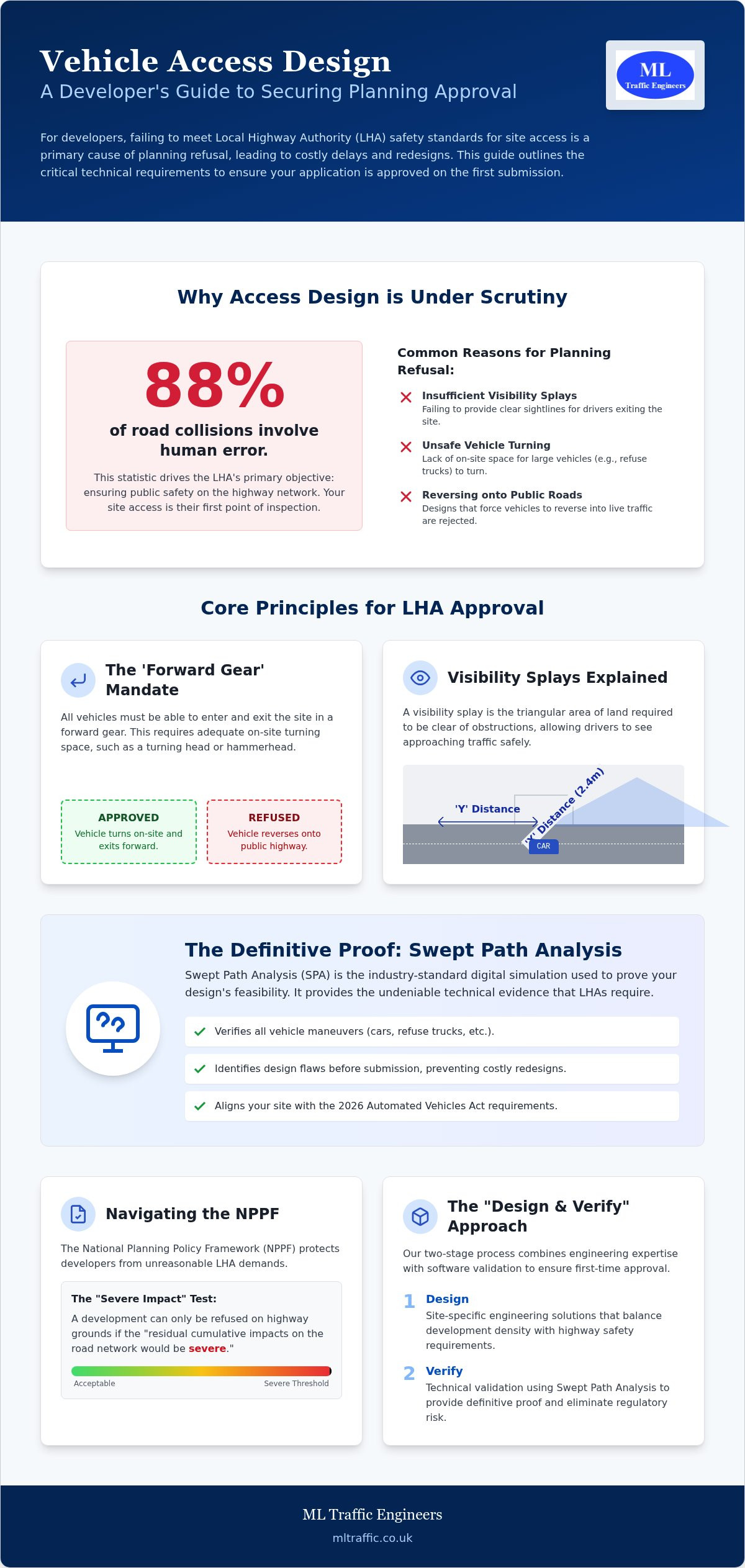
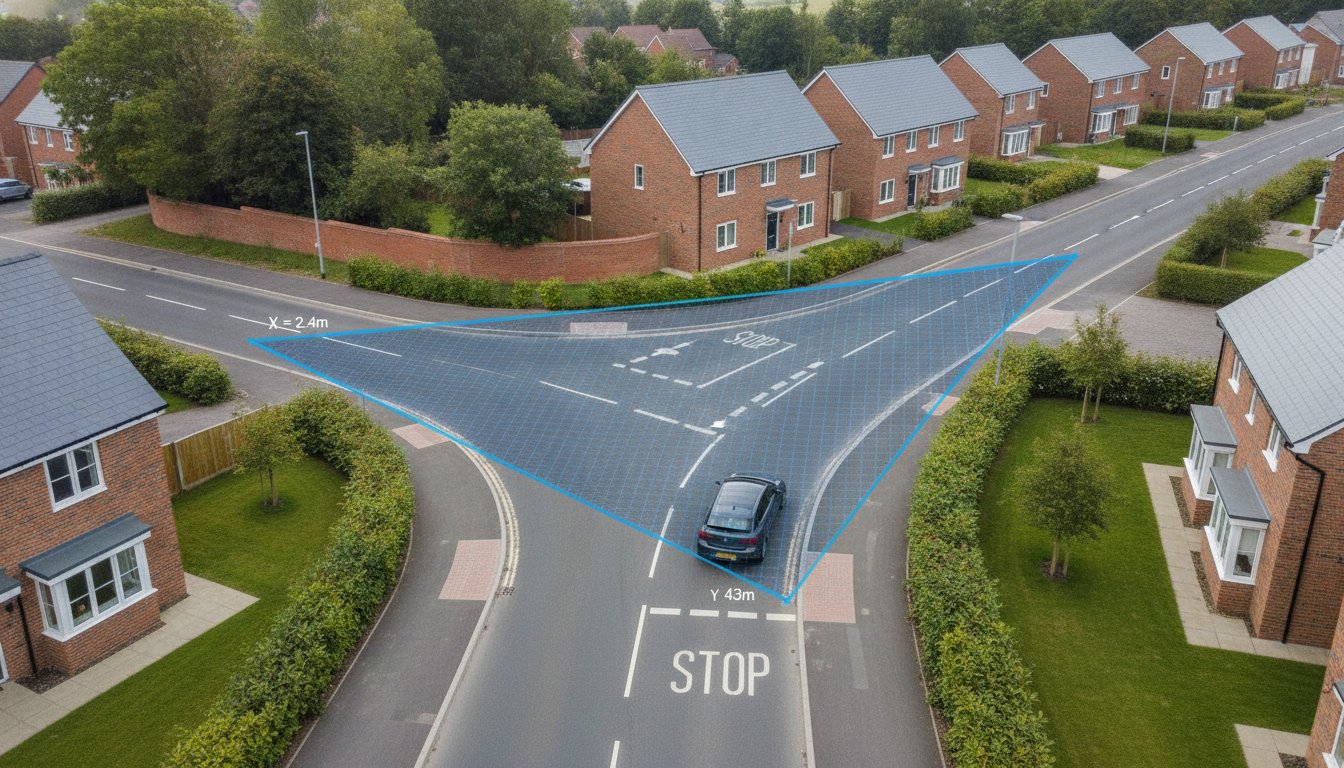
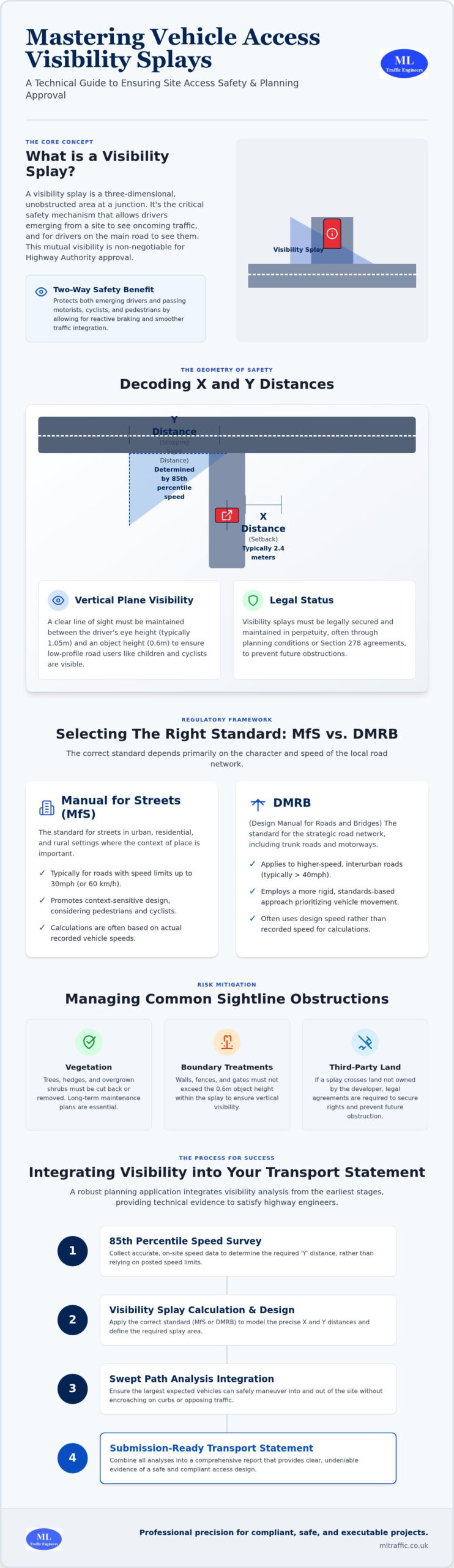
    Vehicle access visibility splays represent the physical area at a junction where sightlines must remain entirely unobstructed to ensure safe movement between a side road and a major road. Unlike a simple 2D drawing, a splay is a three-dimensional envelope of visibility. It ensures that any driver positioned at the junction has a clear, unhindered view of approaching traffic. Precision in these calculations is mandatory. Highway Authorities treat these splays as the primary gatekeepers of site viability, often prioritizing them over architectural aesthetics or unit density. A site with a ‘blind’ access point is often fundamentally undevelopable, as safety remains a non-negotiable requirement for planning approval.

    The safety benefit is strictly two-way. While it is vital for the emerging driver to see oncoming traffic, it’s equally important for drivers on the major road to see vehicles preparing to join the flow. This mutual visibility allows for reactive braking and smoother traffic integration. Adhering to standard road junction design principles ensures that all road users, including cyclists and motorcyclists, are protected from high-speed collisions. In 2026, failing to demonstrate compliant vehicle access visibility splays in your initial application is a leading cause of immediate refusal. Visibility analysis is the cornerstone of a robust Transport Statement, providing the technical evidence needed to satisfy highway engineers.

    The Geometry of Safety: Side Road vs. Major Road

    Visualizing the splay as a triangle is the most effective way to understand your site entrance. The ‘X’ distance is your setback from the major road, while the ‘Y’ distance extends along the main carriageway. The speed of the major road dictates the entire design. Higher recorded speeds require longer ‘Y’ distances to account for vehicle stopping sight distances. In urban development projects, this geometry must also account for pedestrian visibility. Drivers must be able to see pedestrians on the footway before the vehicle crosses their path. We use actual speed data, rather than just posted limits, to ensure the triangle is both safe and realistic.

    Legal and Planning Status of the Splay

    Visibility splays must be maintained in perpetuity. The Highway Authority requires long-term control over this land to prevent future obstructions like overgrown hedges or new fences. If the required splay crosses land you don’t own, you must secure that land through legal agreements or demonstrate that it’s part of the public highway. We often manage these requirements through Section 278 agreements for off-site improvements. These visibility requirements typically appear as strict planning conditions. You’ll often find that you cannot begin work on-site until the access and its associated visibility splays are physically constructed and verified.

    Decoding the Dimensions: Understanding X and Y Distances

    Precision is the difference between a validated planning application and a costly refusal. When designing vehicle access visibility splays, we define the safety area using two primary coordinates: the X and Y distances. The X distance represents the setback from the edge of the major road to the driver’s eye. While 2.4 meters is the standard requirement for most junctions, this measurement is not arbitrary. It allows a driver to see the main road clearly without their vehicle protruding into the flow of traffic. The Y distance, or Stopping Sight Distance (SSD), is the length visible along the major road. This distance must be sufficient for a driver on the main road to see a hazard and come to a safe stop.

    Technical accuracy extends into the vertical plane. We must maintain a clear line of sight between a driver’s eye height, typically 1.05 meters, and an object height of 0.6 meters. This ensures that low-profile road users, such as children or cyclists, are not obscured by boundary treatments. Environmental factors also influence these calculations. Steep gradients or road surfaces prone to moisture can increase braking distances, requiring an extension of the Y distance to maintain safety margins. Following the Manual for Streets (MfS) guidance, we calculate these dimensions based on actual vehicle deceleration rates rather than theoretical ideals.

    When Can the X Distance Be Reduced?

    Reducing the X distance to 2.0 meters is sometimes permissible for lightly trafficked residential drives or in constrained urban environments. However, Highway Authorities often resist this ‘nose-out’ visibility because it forces the front of the vehicle to enter the major road before the driver has a full view. At ML Traffic, we justify these reductions by providing empirical evidence of low traffic volumes or by using Swept Path Analysis to prove that the maneuver remains safe. If you are struggling with a tight site boundary, commissioning professional Traffic Surveys can provide the specific data needed to defend a non-standard design.

    Calculating the Y Distance: The Speed Factor

    The Y distance is directly tethered to the 85th percentile speed of the major road. A 20mph zone typically requires an SSD of 25 meters, whereas a 30mph zone requires 43 meters. It is a common error to rely solely on the posted speed limit. Actual recorded speeds often exceed the limit, and Highway Authorities will demand visibility splays that reflect how the road is used in reality. We use 85th percentile speed data to ensure your design is robust enough to pass a formal safety review.

    MfS vs. DMRB: Selecting the Right Regulatory Standard

    Selecting the correct regulatory framework is a strategic decision that dictates the viability of your site layout. In the UK, we primarily work with two sets of guidance: Manual for Streets (MfS) and the Design Manual for Roads and Bridges (DMRB). MfS is the standard for most urban and residential environments where speeds are 37mph or lower. It prioritizes place-making and utilizes stopping sight distances based on actual vehicle deceleration. Conversely, the DMRB is a more rigid standard designed for trunk roads and high-speed rural routes.

    The ‘grey area’ typically occurs on the urban fringe where a 30mph limit transitions into a 60mph zone. Applying DMRB standards to an urban-edge site often results in excessively large vehicle access visibility splays. These over-engineered designs can consume valuable frontage, reduce your unit count, and ultimately kill site density. We specialize in navigating these transitions, using technical authority to argue for the more appropriate MfS standard when the character of the road supports it. Identifying the most appropriate standard early prevents logistical pressures and ensures your project meets safety benchmarks without sacrificing land.

    The Critical Role of Speed Surveys

    Relying on posted speed limits is a common mistake that leads to conservative, space-wasting designs. We recommend conducting 85th percentile speed surveys to determine the actual speed at which motorists travel past your site. If the 85th percentile speed is lower than the limit, we can often justify shorter Y distances, preserving more of your developable area. For example, on a recent project with restricted frontage, a speed survey proved that actual speeds were significantly lower than the 30mph limit. This allowed for a reduction in the required splay, saving multiple residential units that would have otherwise been lost to visibility requirements. Professional Traffic Surveys provide the empirical data required to challenge assumptions and maximize site potential.

    National vs. Local Highway Authority Variances

    While MfS and DMRB provide national frameworks, local Highway Officers often have their own specific interpretations. Some authorities are more flexible regarding ‘nose-out’ visibility, while others strictly adhere to their own internal design guides. Early pre-application engagement is essential to understand these local nuances before you finalize your site plan. This proactive approach is particularly vital when navigating London’s transport planning system, where high-density constraints require a more tailored technical justification for every meter of visibility. We manage these negotiations on your behalf, ensuring your design aligns with both national standards and local expectations.

    Managing Obstructions and Maintenance within the Splay

    The 0.6m rule is the fundamental benchmark for any object positioned within the visibility envelope. To maintain a clear line of sight between the driver’s eye height (1.05m) and the object height (0.6m), everything within the splay must remain below this 600mm threshold. Common pitfalls include boundary walls, decorative hedges, and seasonal vegetation that grows rapidly. Parked cars represent another significant concern. Highway Authorities will often require new parking restrictions if existing or proposed on-street parking blocks the vehicle access visibility splays.

    Not every object is a prohibited obstruction. Slim signposts, lighting columns, and clear-stemmed trees where the canopy starts above 2.0m are often permitted because they don’t significantly mask a vehicle. However, the cumulative effect of multiple ‘slim’ objects can still lead to a refusal if they create a visual screen. If your site layout is constrained, we can perform a detailed assessment to identify which existing features can be retained and which must be removed to satisfy safety requirements.

    Land Ownership and Control

    For a planning application to succeed, you must demonstrate that the required visibility splays are either within your site’s red-line boundary or on land that is already part of the public highway. If a splay crosses third-party land, you face a significant legal hurdle. You must either purchase that land or secure a legal agreement with the neighbor. In some cases, we utilize Grampian conditions. These are negatively worded planning conditions that prevent development from starting until the off-site visibility is secured. We often facilitate these arrangements through Section 106 or Section 278 agreements to ensure the Highway Authority has the legal right to maintain the sightlines in perpetuity.

    Designing for Longevity

    Maintaining vehicle access visibility splays isn’t just a requirement for the planning phase; it’s a permanent safety obligation. When designing your landscaping scheme, select low-growth species that naturally stay below 0.6m. This prevents future safety breaches caused by overgrown vegetation. As the developer, you remain liable for maintaining these sightlines until the road is formally adopted by the council. For complex projects involving new road infrastructure, our Highway Design S278 & S38 Guide provides deeper insight into the adoption process and long-term maintenance requirements.

    If you’re facing boundary disputes or need a technical justification for a potential obstruction, contact us today to discuss how our Transport Statements can resolve your planning bottlenecks and secure your site’s access.

    Vehicle Access Visibility Splays: The Developer’s 2026 Guide to Planning Success

    Integrating Visibility into Your Transport Statement

    A robust Transport Statement relies on the technical validation of vehicle access visibility splays. It isn’t enough to state that an access point is safe; we must prove it through rigorous data. Our workflow begins with precise site surveys to capture 85th percentile speeds, which then inform our CAD modeling. This transition from raw data to engineered drawings ensures the Highway Officer receives a submission that is technically sound and ready for approval on the first attempt. We present our findings in a logical, sequential format that mirrors the Highway Authority’s own review process, reducing the friction often found in planning negotiations.

    There is a critical synergy between visibility analysis and Swept Path Analysis. While visibility splays ensure drivers can see, Swept Path Analysis proves that vehicles can physically maneuver through the junction without overrunning footways or striking street furniture. We integrate these two disciplines to ensure your site entrance is both visible and navigable. Presenting these reports as a unified technical package demonstrates a comprehensive understanding of junction safety. This combined approach reduces the likelihood of supplementary information requests that can stall your project for weeks.

    Beyond the Drawing: The Technical Report

    The technical report goes beyond simple geometry. We use evidence-based engineering to justify deviations from standard guidance when site constraints make literal compliance impossible. This approach is especially critical when following our Transport Assessment London Guide, where high-density environments require creative but safe solutions. Our safety-critical designs are backed by professional indemnity insurance, providing developers with the assurance that their project’s technical foundation is legally and professionally robust. We don’t just provide drawings; we provide the engineering justification needed to win planning appeals.

    Next Steps for Your 2026 Planning Application

    Early-stage feasibility is the most effective way to protect your site’s value. We recommend checking vehicle access visibility splays before you finalize your site layout. Identifying a visibility constraint during the initial design phase allows for minor adjustments to building positions or frontage treatments. Waiting until the full application stage to discover an unsafe access point often results in expensive redesigns and lost units.

    To streamline your 2026 planning application, you should request a site-specific access review as early as possible. We provide a clear roadmap from initial assessment to final Highway Authority sign-off, managing the logistical and regulatory pressures so you don’t have to. By choosing a partner that understands the intricate relationship between safety standards and commercial site viability, you ensure your project moves forward with unwavering reliability and precision.

    Securing Site Viability Through Technical Precision

    Securing planning approval in 2026 requires more than a compliant drawing; it demands an evidence-based approach to highway safety. By mastering the geometric requirements of X and Y distances and selecting the appropriate regulatory standard, you protect your development from the risk of ‘unsafe access’ refusals. Integrating these vehicle access visibility splays with detailed data collection ensures your site maximizes its developable area while meeting the Highway Authority’s stringent benchmarks. We’ve explored how speed surveys and proactive obstruction management turn regulatory hurdles into manageable design elements.

    Our team acts as your dependable technical partner, offering specialized expertise in MfS and DMRB compliance alongside comprehensive Transport Planning support. We’re highly experienced in Section 278 negotiations, ensuring that off-site improvements are handled with professional integrity. Secure your site access approval with a professional visibility analysis from ML Traffic Engineers. We provide the rapid response and precision necessary to reduce logistical pressures and keep your project on schedule. Let’s ensure your site access is safe, compliant, and ready for construction.

    Frequently Asked Questions

    What is the standard X distance for a visibility splay in the UK?

    2.4 meters is the standard X distance for the vast majority of UK road junctions. This setback represents the distance from the edge of the major road to the driver’s eye, allowing for a clear view of approaching traffic without the vehicle protruding into the carriageway. In certain constrained urban settings with low traffic speeds, some Highway Authorities may permit a reduction to 2.0 meters, though this often requires a robust technical justification.

    Can a visibility splay go over a neighbour’s land?

    A visibility splay can cross third-party land, but you must demonstrate legal control over that area to ensure it remains unobstructed. The Highway Authority requires sightlines to be maintained in perpetuity, so you’ll typically need a formal easement, a land purchase, or a Grampian planning condition. If you cannot prove the land will be kept clear, the vehicle access visibility splays will be considered ‘unprotected’ and likely lead to a planning refusal.

    What height can objects be within a visibility splay?

    Objects within the splay must generally remain below a height of 0.6 meters above the ground. This threshold ensures a clear line of sight between a driver’s eye height, which is typically 1.05 meters, and lower-profile hazards or road users. While some slim items like lighting columns or signposts are often permitted, they must not cumulatively block the driver’s field of vision.

    Do I need a visibility splay for a private driveway?

    You do need a visibility splay for a private driveway if it creates a new access or intensifies an existing one onto the public highway. Safety standards apply to all access points to prevent collisions between emerging vehicles and passing traffic. Planning officers will scrutinize the access as part of your application to ensure it doesn’t compromise the safety of the road network.

    How do I calculate the Y distance for a 30mph road?

    The Y distance for a 30mph road is typically 43 meters when following Manual for Streets (MfS) guidance. However, this distance is based on the stopping sight distance required for a vehicle traveling at the 85th percentile speed of the road. If actual recorded speeds are higher than 30mph, the required Y distance will increase to ensure drivers have enough time to react and stop safely.

    What is the difference between MfS and DMRB visibility standards?

    Manual for Streets (MfS) is designed for urban and residential environments with speeds of 37mph or less, focusing on place-making and actual driver behavior. The Design Manual for Roads and Bridges (DMRB) is a more conservative standard used for high-speed rural routes and trunk roads. Applying the stricter DMRB standards to an urban site can result in unnecessarily large splays that significantly reduce your developable land.

    Can trees be planted within a visibility splay?

    Trees can be planted within a visibility splay provided they are clear-stemmed and don’t create a visual screen. The trunk must be narrow, and the canopy should start at a minimum of 2.0 meters above ground level to keep the 0.6m to 2.0m visibility envelope clear. You must also select species that won’t grow to obstruct the splay as they mature, as you are responsible for their ongoing maintenance.

    How much does a visibility splay survey cost for a planning application?

    The cost of a visibility splay assessment varies based on the size of the site and the level of data collection required. A survey that includes 85th percentile speed data or topographical mapping will involve different requirements than a desk-based assessment. Developers should seek a tailored proposal from a specialist engineer to ensure all Highway Authority requirements are met without overspending on unnecessary surveys.

    Michael Lee

    Article by

    Michael Lee

    Transport planner with over 35 years' experience.

    Disclaimer

    The content on mltraffic.co.uk, including all technical articles, guides, and resources, is provided for general informational and educational purposes only. It is not intended to constitute professional advice in traffic engineering, transportation planning, development approvals, or any other technical or legal field.
    While ML Traffic Engineers makes every reasonable effort to ensure the accuracy, completeness, and timeliness of the information published, we do not provide any warranties or representations (express or implied) regarding its reliability, suitability, or availability for any particular purpose. Any reliance you place on the content is strictly at your own risk.
    In no event shall ML Traffic Engineers, its directors, employees, authors, or affiliates be liable for any direct, indirect, incidental, special, consequential, or punitive damages (including, without limitation, loss of profits, data, or business opportunities) arising out of or in connection with the use of, or inability to use, any information provided on this website.
    The articles and guides on this site are not a substitute for engaging a qualified, professional traffic engineer to assess your specific project requirements. For tailored advice, compliance assessments, or traffic engineering services, please contact a competent professional.
    This disclaimer may be updated from time to time without notice. By accessing or using this website, you agree to be bound by the most current version of this disclaimer.

  • Guidance on Transport Assessment Thresholds UK: 2026 Developer’s Manual

    Guidance on Transport Assessment Thresholds UK: 2026 Developer’s Manual

    Did you know that 42% of minor development applications across London boroughs face immediate delays at the validation stage because of insufficient highway data? It’s a frustrating reality for developers who find themselves caught between the “withdrawn” 2007 DfT guidance and the nuanced requirements of the current National Planning Practice Guidance. Understanding the specific transport assessment thresholds uk planners expect is no longer about following a static checklist; it’s about navigating a landscape where local authorities hold significant discretionary power.

    You likely recognize that a “one size fits all” approach leads to over-engineered reports that inflate project costs or, worse, insufficient data that stalls your application for months. This 2026 manual provides the clarity you need to move forward with confidence. We’ll break down the latest triggers for full assessments versus simpler statements, including the specific 80-unit residential threshold in London and the “vision-led” shift in the delayed NPPF. By the end of this guide, you’ll know how to secure a professional report that passes council scrutiny the first time while keeping your technical documentation proportionate to your project’s impact.

    Key Takeaways

    • Recognise why the 2007 DfT Guidance remains the essential technical framework for Local Highway Authorities despite its formal withdrawal.
    • Understand the specific transport assessment thresholds uk local authorities use to determine if your project requires a full Assessment or a simpler Statement.
    • Identify the mandatory components of a compliant report, including TRICS trip generation analysis and baseline traffic surveys.
    • Leverage technical data such as Swept Path Analysis to justify your site design and meet statutory requirements efficiently.
    • Manage the project lifecycle from initial scoping to final negotiation to prevent validation delays and minimise technical reporting costs.

    What is the DfT Guidance on Transport Assessment in 2026?

    The Department for Transport (DfT) Guidance on Transport Assessment (GTA) remains the foundational technical framework for transport planning across the United Kingdom. Although the original 2007 document was formally “withdrawn” by the government, its technical methodologies are still mandated by the majority of Local Highway Authorities. This guidance provides the specific analytical tools required to determine if a project meets the transport assessment thresholds uk planners monitor for validation. Without this framework, there would be no consistent way to measure a development’s impact on highway safety and network capacity.

    To better understand how these technical assessments fit into the wider planning framework, watch this helpful video:

    In 2026, the industry has shifted away from the traditional “Predict and Provide” model toward “Vision and Validate” strategies. This approach prioritises sustainable transport outcomes and active travel infrastructure over simple road capacity expansion. The primary technical goal of any modern report is to demonstrate that a development’s residual cumulative impact is not “severe.” Under current planning law, “severe” is the specific legal benchmark that determines whether a highway authority will object to your application. ML Traffic Engineers UK uses these DfT principles to ensure that every technical submission is robust enough to withstand legal and planning scrutiny.

    The Evolution from 2007 DfT Standards to NPPF

    The National Planning Policy Framework (NPPF) and National Planning Practice Guidance (NPPG) have streamlined reporting requirements, but they lack the granular engineering detail found in the 2007 GTA. This is why professional consultants still rely on the older guidance for junction modelling and trip distribution. While the NPPG sets the policy direction, the GTA provides the technical “how-to” that keeps the road network functional. This dual-track approach ensures that your project complies with both high-level sustainability goals and ground-level safety requirements, providing a reassuring path to approval.

    Why Thresholds Matter for Your Planning Application

    Identifying the correct reporting tier is essential for avoiding unnecessary technical work and inflated consultancy fees. If you incorrectly identify the level of reporting required, you risk receiving a “Regulation 25” request for further information. These formal demands for data can stall a project for weeks or months while additional surveys are gathered. ML Traffic Engineers UK identifies the correct transport assessment thresholds uk planners expect during the pre-application phase. This ensures your submission aligns with local borough or county-wide policies from the start, preventing the validation delays that frequently derail development timelines.

    Indicative Transport Assessment Thresholds for UK Developments

    Determining the correct transport assessment thresholds uk local authorities apply is the most critical step in your pre-application strategy. While national guidelines exist, these figures are indicative rather than absolute. The actual requirement often hinges on a “Scoping” exercise where we negotiate the scale of reporting with the Local Highway Authority (LHA). This prevents you from paying for a full Assessment when a leaner Statement would suffice. Our team uses the Department for Transport’s Transport Analysis Guidance (TAG) to align technical methodologies with council expectations from day one.

    Thresholds are generally based on the land-use class and the physical scale of your proposed development. Residential schemes usually require a full Transport Assessment once they exceed 80 dwellings. However, in sensitive areas or congested urban centres, this threshold can drop significantly. For instance, our London Transport Assessment guide highlights that some boroughs require full reporting for as few as 30 to 40 units if the site sits within an Air Quality Focus Area. Commercial and retail projects generally face triggers between 1,000sqm and 2,500sqm of gross floor area.

    Common Triggers for Transport Statements vs. Assessments

    A Transport Statement is typically sufficient for smaller sites, such as residential developments between 30 and 50 dwellings. These reports focus on localised impacts and immediate site access. A full Assessment becomes mandatory for larger schemes or any project impacting the strategic road network. You should be aware that a council might “upgrade” a Statement to a full Assessment in high-congestion zones. This usually happens if the development is expected to generate between 30 and 50 vehicle movements during peak hours, regardless of the unit count. If you’re unsure which tier applies to your site, our transport planning services can provide an initial scoping opinion.

    Land-Use Specific Threshold Examples

    The type of activity on-site dictates the level of scrutiny. Retail developments (A1/A3) have varying triggers; a food retail outlet often requires a full Assessment at a lower floor area than a non-food warehouse because of higher trip frequencies. For office spaces (B1), square footage isn’t the only metric. Planners look closely at employee density and the resulting pressure on local public transport hubs. Industrial sites (B2/B8) focus heavily on HGV movements. In these cases, the LHA prioritises swept path requirements and delivery scheduling over simple car trip counts to ensure the local network remains safe and functional.

    Core Components of a DfT-Compliant Transport Report

    A DfT-compliant report must be precise to withstand the scrutiny of Local Highway Authority officers. Every successful submission begins with a detailed baseline of existing site conditions. We examine the current transport network, identifying existing bottlenecks and safety records within the immediate vicinity. This evidence base is essential for determining how your project fits within the established transport assessment thresholds uk planners use to judge impact. We follow the Planning Practice Guidance for Transport Assessments to ensure every technical chapter aligns with national standards.

    Trip generation analysis is the technical heart of the report. Using the latest TRICS database standards for 2026, we calculate the expected volume of vehicle, pedestrian, and cycle movements. This isn’t just about cars; we must demonstrate a holistic understanding of how people will access your site. We audit sustainable travel options, assessing the quality of walking and cycling routes and calculating Public Transport Accessibility Level (PTAL) scores. If our analysis identifies potential network stress, we develop a robust mitigation strategy. This ensures your planning application remains viable by addressing negative impacts before they become grounds for refusal.

    The Critical Role of the Scoping Note

    We never start a full report without first securing a Scoping Note. This allows us to negotiate the study area with the Highway Authority, ensuring we only model the junctions that truly matter. We agree on the appropriate software for the task, whether that’s ARCADY for roundabouts, PICADY for priority junctions, or LinSig for traffic signals. The Scoping Note serves as the formal technical agreement that prevents redundant work and ensures the council accepts our methodology from the outset.

    Trip Generation and Modal Split

    TRICS data allows us to predict trip volumes based on real-world surveys from similar developments. We refine these “standard” rates by applying local factors, such as high PTAL ratings in urban centres. This process, known as modal split analysis, determines the percentage of users arriving by each transport mode. Travel Plan consultants are often brought in at this stage to introduce measures that actively reduce car dependency. By shifting trips toward walking or cycling, we can often lower the predicted traffic impact enough to meet local policy requirements.

    Guidance on Transport Assessment Thresholds UK: 2026 Developer’s Manual

    Technical Methodologies: Moving Beyond the Guidance

    Technical precision is the only way to prove a site functions safely once you’ve identified the relevant transport assessment thresholds uk local authorities require. Meeting these benchmarks involves more than just interpreting policy; it requires empirical data that demonstrates your design is viable. We follow a logical, sequential process to build this evidence base. Our methodology ensures that even if your development sits just below major transport assessment thresholds uk, the technical data remains robust enough to withstand planning committee scrutiny. This process moves from initial baseline surveys to advanced digital simulations and junction capacity modelling.

    Swept Path Analysis: Proving Design Feasibility

    A critical component of any modern submission is proving that essential vehicles can navigate your site without conflict. We use Swept Path Analysis to ensure refuse trucks, fire tenders, and delivery vehicles can enter, turn, and exit safely. Swept Path Analysis is a digital simulation of vehicle movement used to prevent costly physical redesigns by identifying potential collisions with kerbs or buildings before construction begins. This technical rigor is especially important for multi-use developments where HGV movements must coexist with pedestrian zones. By providing this data early, we reduce the regulatory pressure on your team and ensure the Local Highway Authority (LHA) remains satisfied with your site layout.

    Traffic and Parking Surveys

    Accurate data collection is the foundation of a successful report. We determine whether your site requires Manual Classified Counts (MCC) to identify specific vehicle types and pedestrian movements, or Automated Traffic Counts (ATC) for 7-day volume and speed data. This choice depends on the specific concerns of the LHA regarding local network stress. In sustainable urban locations, we use this data to justify lower parking provision, aligning with modern “car-free” planning mandates. For residential projects, we strictly adhere to the “Lambeth” or “Bentley” methodologies for parking surveys. These industry benchmarks ensure that our findings on overnight parking stress are accepted as a reliable basis for decision-making.

    Secure your project’s future and avoid validation delays by requesting a professional traffic survey or swept path analysis from our expert team today.

    ML Traffic Engineers UK provides the technical rigor needed to satisfy DfT standards in 2026. We manage the entire project lifecycle from the first scoping note to the final LHA negotiation. Our reports are decision-ready. This proactive approach minimizes technical queries that often stall developers at the validation stage. We understand that a rejected statement can stall a project for up to 16 weeks. We balance technical compliance with a commercial understanding of project viability. Our team ensures your documentation is proportionate to the development’s impact, reducing unnecessary technical overhead while maintaining safety standards.

    Expert Reporting for UK Developers

    We specialize in the preparation of Transport Statements and Assessments for all development scales. Since our founding in 2014, we’ve built deep expertise in UK planning law and regional highway requirements. We ensure your project adheres to the latest 2026 industry benchmarks and safety standards. Navigating the transport assessment thresholds uk planners use requires a tailored approach rather than a generic template. We use technical data, such as Swept Path Analysis, to justify lower-tier reporting where appropriate. This saves you from unnecessary consultancy fees while maintaining full regulatory compliance. View our Transport Statement buying guide for smaller sites to see how we streamline the process for minor developments.

    Get Started on Your Transport Assessment

    Contact our team for a preliminary review of your site’s specific transport triggers. We identify the exact transport assessment thresholds uk authorities will apply to your specific land-use class. Our integrated survey services provide the data foundations your application needs to succeed. We handle everything from TRICS data collection to complex junction modelling and Travel Plan coordination. This comprehensive support means you don’t have to manage multiple technical vendors or worry about conflicting data. We act as your dependable expert partner, ensuring every report passes council scrutiny the first time. Contact ML Traffic Engineers UK today for expert guidance on your transport assessment and secure your project’s timeline with reliable data.

    Securing Your Project Timeline with Technical Precision

    Successfully navigating the transport assessment thresholds uk local authorities demand is about balancing technical evidence with strategic negotiation. You now understand that a “vision-led” approach, supported by accurate TRICS modelling and Swept Path Analysis, is essential for bypassing validation delays and minimising technical reporting costs. These rigorous methodologies ensure your site design is safe, functional, and compliant with both national and local policy frameworks.

    Since 2014, ML Traffic Engineers UK has acted as a vital partner for developers across England. We provide the technical authority needed to satisfy statutory requirements while maintaining a clear focus on your project’s commercial viability. By managing the full project lifecycle from initial scoping to final negotiation, we reduce the regulatory pressure on your team and ensure every report is decision-ready for the planning committee.

    Secure your planning approval with a DfT-compliant Transport Assessment from ML Traffic Engineers UK.

    With the right technical foundations in place, you can move forward with confidence that your development meets every safety and sustainability benchmark required for a successful outcome.

    Frequently Asked Questions

    Is the 2007 DfT Guidance on Transport Assessment still valid in 2026?

    The 2007 DfT Guidance is formally withdrawn, but its technical methodologies remain the industry standard for most Local Highway Authorities in 2026. Planners still expect reports to follow its rigorous structure for junction modelling and trip distribution. It provides the mathematical foundation that modern NPPF policies lack, ensuring technical consistency across different UK regions and providing a reliable framework for developers.

    What is the specific threshold for a Transport Assessment for a residential site?

    Residential developments typically require a full Assessment once they exceed 80 units, though this varies significantly by borough. In sensitive urban areas or Air Quality Focus Areas, the transport assessment thresholds uk planners apply can drop to as few as 30 to 40 dwellings. You should always consult the local highway authority’s specific policy during the pre-application phase to confirm the required reporting tier.

    Can a Transport Statement be rejected if the development is below the threshold?

    Yes, a council can reject a Transport Statement or demand an “upgrade” to a full Assessment if the site’s impact is deemed significant. This often occurs if a development generates more than 30 vehicle movements during peak hours or sits near a congested junction. Insufficient highway data is a leading cause of validation delays, even for projects that fall below indicative national thresholds.

    How long does it take to prepare a DfT-compliant Transport Assessment?

    Preparation usually takes between four and eight weeks, depending on the complexity of the required traffic surveys. This timeline includes the initial scoping period with the local authority, data collection, and technical modelling. Factoring in the time needed for Manual Classified Counts or 7-day Automated Traffic Counts is essential for maintaining your project’s overall delivery schedule and avoiding last-minute delays.

    Do I need a Travel Plan if my development requires a Transport Assessment?

    Most developments that trigger a full Transport Assessment also require a Travel Plan to promote sustainable transport. This document outlines specific measures to reduce car dependency, such as cycle parking or public transport incentives. Integrating these reports ensures your application meets the sustainability criteria set out in the National Planning Policy Framework and aligns with local borough environmental goals.

    What happens if the assessment shows a ‘severe’ impact on the local road network?

    If an assessment identifies a “severe” impact, you must propose a robust mitigation strategy to resolve the issue. This might involve junction improvements, site access redesigns, or financial contributions toward local infrastructure. Failure to mitigate a severe residual cumulative impact is a primary ground for refusal under current UK planning laws, making technical precision and early mitigation planning vital for success.

    What is the TRICS database and why is it required for transport reporting?

    TRICS is the national standard system for trip generation analysis, providing data from thousands of established sites across the UK. It allows engineers to predict how many vehicle, pedestrian, and cycle trips a new development will generate based on similar existing land uses. Using the latest 2026 TRICS version is a non-negotiable requirement for any report to be accepted by a Local Highway Authority.

    How much does a professional Transport Assessment cost for a UK developer?

    The cost of a professional report depends on the scale of the development and the complexity of the required technical surveys. A full Assessment for a major scheme involves higher technical overhead than a simple Statement due to the extensive junction modelling and data collection involved. We recommend requesting a site-specific quote to ensure your technical documentation is correctly sized for the transport assessment thresholds uk councils enforce.

    Michael Lee

    Article by

    Michael Lee

    Transport planner with over 35 years' experience.

    Disclaimer

    The content on mltraffic.co.uk, including all technical articles, guides, and resources, is provided for general informational and educational purposes only. It is not intended to constitute professional advice in traffic engineering, transportation planning, development approvals, or any other technical or legal field.
    While ML Traffic Engineers makes every reasonable effort to ensure the accuracy, completeness, and timeliness of the information published, we do not provide any warranties or representations (express or implied) regarding its reliability, suitability, or availability for any particular purpose. Any reliance you place on the content is strictly at your own risk.
    In no event shall ML Traffic Engineers, its directors, employees, authors, or affiliates be liable for any direct, indirect, incidental, special, consequential, or punitive damages (including, without limitation, loss of profits, data, or business opportunities) arising out of or in connection with the use of, or inability to use, any information provided on this website.
    The articles and guides on this site are not a substitute for engaging a qualified, professional traffic engineer to assess your specific project requirements. For tailored advice, compliance assessments, or traffic engineering services, please contact a competent professional.
    This disclaimer may be updated from time to time without notice. By accessing or using this website, you agree to be bound by the most current version of this disclaimer.
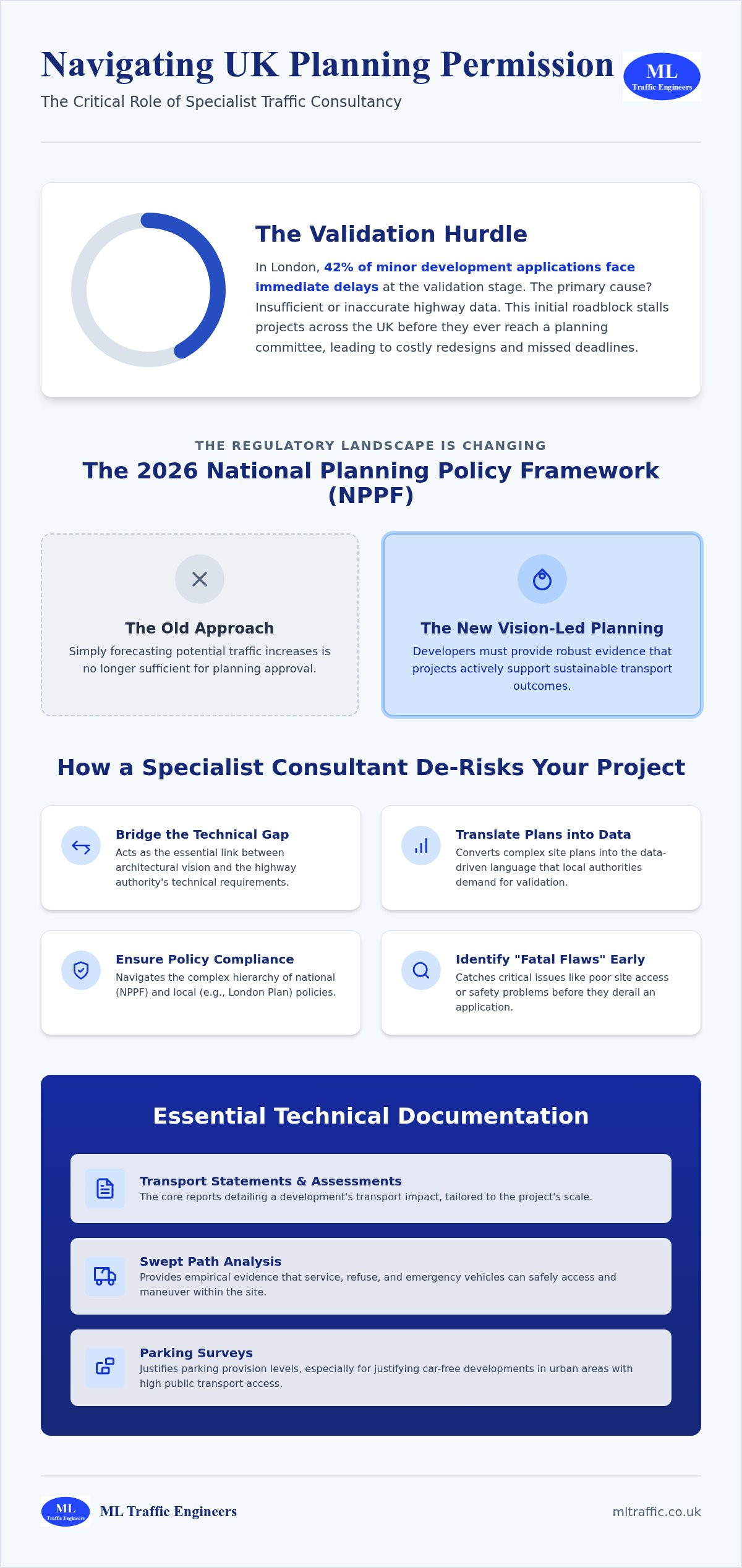
  • 2026 Brownfield Development Transport Statement Guide

    2026 Brownfield Development Transport Statement Guide

    Did you know that 42% of minor development applications in London face immediate delays at the validation stage due to insufficient highway data? This bottleneck often stems from the complexity of drafting a robust transport statement for brownfield development that satisfies both national mandates and local borough requirements. In 2026, the pressure to deliver high-density housing on urban sites is immense, yet the technical hurdles regarding traffic mitigation and new Active Travel England standards have never been higher.

    It’s frustrating to see viable regeneration schemes stalled by conflicting policies or a failure to justify density through movement fluidity. You likely recognise that securing permission for high-density schemes requires more than just meeting basic thresholds; it demands a precise, data-driven strategy. This guide ensures you master the technical requirements and statutory frameworks needed to secure planning approval for even the most complex brownfield projects. We provide a clear roadmap for Section 106 and 278 negotiations, showing you how to optimise site layouts and satisfy the current “vision-led” approach to transport planning while maintaining compliance with the latest NPPF reforms.

    Key Takeaways

    • Navigate the latest NPPF updates and the “brownfield presumption” to effectively justify high-density regeneration in 2026.
    • Master the technical requirements of a transport statement for brownfield development to ensure your project meets Active Travel England’s stringent connectivity standards.
    • Optimise site layouts by integrating pedestrian priority zones and sustainable infrastructure that satisfy borough-specific parking and transport targets.
    • Utilise precise TRICS analysis and comprehensive Traffic Surveys to provide the robust evidence needed for successful Section 106 and 278 negotiations.
    • Reduce the risk of planning delays by adopting a proactive, vision-led approach to highway authority liaison from the pre-application stage.

    Strategic Importance of Transport Planning for Brownfield Development

    In 2026, the success of urban regeneration hinges on movement. A comprehensive transport statement for brownfield development acts as more than a box-ticking exercise for the local planning authority. It’s a strategic blueprint that justifies high-density schemes on land that was previously used for industrial or commercial purposes. If you’re asking What is a brownfield site? in a planning context, it’s often a location where existing infrastructure is already strained. This requires a sophisticated technical approach to mitigate traffic impacts without compromising the site’s commercial viability.

    The industry has moved decisively away from the traditional “predict and provide” model. Planning authorities now demand a “decide and provide” or “vision-led” approach. This means developers must proactively decide on a sustainable transport outcome and provide the infrastructure to support it. This shift makes transport the make-or-break factor for regeneration approval. Without a robust strategy, local authorities frequently refuse applications based on perceived congestion or safety risks in already dense urban centres. Precision in your data collection is the only way to counteract these objections.

    Unlocking Site Potential Through Movement

    Effective transport planning identifies physical constraints before they become costly design errors. For example, Public Transport Accessibility Level (PTAL) scores directly dictate the maximum developable density in many UK cities. High-density residential blocks require excellent connectivity to justify lower parking ratios. By integrating mixed-use requirements into a single cohesive strategy, you can maximise the developable area while ensuring the site remains functional for deliveries, emergency services, and residents. We often use Swept Path Analysis at the inception stage to identify tight turning circles or access issues that could stall a project later.

    Economic and Social ROI of Transport Integration

    The technical precision of a transport statement for brownfield development ensures that Section 106 and 278 negotiations remain focused on viable, cost-effective improvements. Investing in strategic transport integration yields significant economic returns. Enhanced connectivity increases land value and makes a development more attractive to commercial tenants and residents alike. By meeting 15-minute city criteria, where essential services are accessible within a short walk or cycle, you satisfy modern urban planning goals that prioritise social well-being. Early-stage traffic modelling helps reduce long-term infrastructure costs by identifying the most efficient ways to manage vehicle movements without over-engineering the local road network.

    Securing planning permission in 2026 requires a precise understanding of the shifting legislative landscape. The National Planning Policy Framework (NPPF) now places “substantial weight” on the value of using suitable brownfield land within settlements. For the UK’s 20 largest towns and cities, a “brownfield presumption” is in effect. This makes it significantly harder for local authorities to refuse housing applications on these sites if they fail to meet house-building targets. However, this presumption doesn’t bypass transport requirements. A transport statement for brownfield development remains the primary technical document used to prove that a high-density scheme won’t negatively impact the local highway network.

    Local Plan requirements have become increasingly specific, with many boroughs now setting rigorous 2026 transport targets that prioritise active travel over private vehicle use. Active Travel England (ATE) now acts as a statutory consultee on a wider range of applications, applying strict design standards for cycling and walking infrastructure. When entering Section 106 and Section 278 negotiations, having accurate, site-specific data is your strongest lever. It prevents local authorities from requesting disproportionate financial contributions for off-site highway works. This strategic focus on sustainable transport solutions for brownfield sites aligns with modern urban planning principles, ensuring that regeneration projects contribute positively to both local communities and broader environmental goals.

    Transport Assessments vs. Transport Statements

    Identifying the correct level of reporting is vital to avoid validation delays. Generally, a transport statement is required for developments generating between 30 and 50 vehicle movements during peak hours. If your regeneration project exceeds these thresholds, you’ll likely need a more detailed Transport Assessment. These reports must address the cumulative impact of your project, considering how new residents or commercial tenants affect the wider urban highway network already operating near capacity. If you’re unsure which report your site requires, reviewing our technical services can help clarify the necessary scope of work.

    The Role of Travel Plans in Mitigation

    For constrained brownfield sites, Travel Plans are indispensable tools for reducing perceived traffic impacts. These documents outline a long-term management strategy to encourage sustainable travel patterns among site users. Council officers increasingly look for “Framework Travel Plans” for phased regeneration schemes, which provide a flexible structure for future occupiers. By committing to clear monitoring and management strategies, you can often justify lower parking provisions, which in turn maximises your developable floor area and improves the project’s overall viability.

    Prioritising Sustainable Connectivity and Active Travel

    In 2026, the design of urban regeneration projects must strictly adhere to the Hierarchy of Road Users. This principle places pedestrians and cyclists at the top of the design priority list, followed by public transport and shared mobility. A technical transport statement for brownfield development must reflect this hierarchy to pass scrutiny from Active Travel England and local highway authorities. Urban centres have seen a 30% increase in light van movements over the last five years, making the physical separation of service vehicles from vulnerable road users a functional necessity for site safety.

    Successful site layouts now integrate high-quality, secure cycle storage and pedestrian priority zones as standard features. This isn’t merely a design preference; it’s a requirement to meet modern sustainability targets and local plan density requirements. Modern regeneration car parks must also feature comprehensive EV charging infrastructure. Local borough plans increasingly mandate that every residential space or a high percentage of commercial spaces include active charging points. Reducing car dependency is the primary goal, but you must achieve this without compromising the site’s accessibility for those with mobility issues or essential service needs.

    Maximising Public Transport Integration

    Brownfield sites are frequently located in PTAL-rich areas. High Public Transport Accessibility Levels allow you to justify lower parking ratios, which directly increases your developable floor area and project ROI. According to UK Government Guidance on Transport Assessments, developers should prioritise sites with existing high-quality transport links to minimize environmental impact. In London and other major cities, the trend is moving toward car-free developments. You might be required to co-fund public transport improvements through planning obligations if existing hubs are near capacity. Ensuring that the journey from a train station or bus stop to your site is safe and intuitive is a key part of the technical justification for high-density schemes.

    Designing for Active Travel Compliance

    Meeting LTN 1/20 standards for cycle infrastructure is now a non-negotiable foundation for urban projects. Your site layout must provide safe, well-lit pedestrian routes that encourage a genuine modal shift away from private cars. A robust transport statement for brownfield development uses empirical data from Traffic Surveys to prove that car-free or low-car developments are viable in specific urban contexts. These surveys provide the evidence needed to satisfy council officers that your project won’t lead to overspill parking on adjacent streets. By designing for inclusivity and safety from the inception, you reduce the risk of costly redesigns during the planning process.

    Technical Analysis Tools: Securing Approval for Constrained Sites

    Technical analysis provides the empirical foundation for a robust transport statement for brownfield development. Without precise data, regeneration projects on constrained sites often fail at the first hurdle of planning validation. We use the TRICS database to model trip generation for complex mixed-use developments. This tool allows us to predict how new residents, workers, and visitors will interact with the local highway network. By comparing this data with existing site usage, we often demonstrate a negligible net increase in traffic. This evidence is vital for justifying high-density schemes in areas where the highway network is already operating near capacity.

    Justifying parking provision is equally critical for site viability. We rely on empirical survey data rather than arbitrary standards to determine the necessary parking levels. This approach is essential for sites where space is at a premium and every square metre counts toward the project’s bottom line. Accurate data collection reduces project risk and provides a clear roadmap for highway authority negotiations. Precision here ensures that you aren’t forced to provide more parking than the site requires, which preserves valuable developable area.

    Swept Path Analysis for Constrained Sites

    In tight urban environments, Swept Path Analysis is a non-negotiable requirement for fire tender and refuse access. We use AutoTurn software to simulate the movement of large vehicles, ensuring that they can navigate tight junctions and site entrances without conflict. This technical validation prevents costly design revisions by identifying access issues at the pre-application stage. Validating vehicle movements early ensures your site layout is functional, safe, and fully compliant with the latest highway authority standards.

    Parking and Traffic Surveys

    To justify car-free or car-capped developments, we conduct detailed parking stress surveys. In London, this frequently involves applying the Lambeth Methodology to assess overnight parking availability on adjacent streets. These surveys provide the evidence needed to satisfy council officers that your project won’t result in parking overspill. Additionally, we use traffic counts to model junction capacity. This data helps us identify potential congestion levels and propose mitigation strategies that keep the highway network moving efficiently. If you need precise technical data to support your planning application, our team can provide the comprehensive traffic surveys required for your site.

    Unlocking Regeneration Success with ML Traffic Engineers UK

    Specialised transport planning reduces project risk and mitigates the threat of costly planning delays. At ML Traffic Engineers UK, we recognise that a transport statement for brownfield development is a high-stakes document that requires absolute precision. We act as your technical partner throughout the full project lifecycle, managing the regulatory pressures that often stall urban schemes. Our team provides a reassuring presence, delivering an all-encompassing service that allows you to focus on site delivery while we handle the intricate highway requirements. You don’t have to navigate these technical hurdles alone.

    We adopt a proactive approach to highway authority liaison, often securing pre-application advice to resolve potential conflicts early. This readiness ensures that our technical reporting, from basic statements to complex analysis, aligns with local expectations. ML Traffic Engineers UK supports developers across England with data-driven solutions that justify density and movement fluidity. By engaging with us early, you gain an expert partner dedicated to providing a clear, technical roadmap for your regeneration goals. Our constant availability ensures that your project remains a priority from inception to completion.

    Why Technical Precision Matters

    Expert, evidence-based reporting is the only way to avoid a refusal on transport grounds. Our experience with high-density urban regeneration ensures your transport statement for brownfield development is robust enough to withstand planning committee scrutiny. We provide tailored strategies that meet both commercial and planning objectives, ensuring your site remains viable. We understand the unique constraints of constrained sites and provide the technical authority needed to satisfy strict regulatory standards. Every report we produce acts as a non-negotiable foundation for your project’s success.

    Next Steps for Your Planning Application

    Securing the right support is the first step toward a successful submission. You can obtain a Transport Statement quote for your project to clarify the technical scope and requirements. In the 2026 planning cycle, it’s vital to allow sufficient time for Traffic Surveys and report preparation to ensure all data is current. Contact ML Traffic Engineers UK for a preliminary site access and feasibility review to ensure your regeneration project remains on track and compliant with all standards.

    Accelerating Your Regeneration Project Approval

    Securing a successful outcome in 2026 requires more than just meeting minimum standards; it demands a vision-led approach that prioritises movement fluidity. As discussed, your transport statement for brownfield development is the cornerstone of this process, providing the technical evidence needed to justify high-density urban schemes. By addressing site-specific constraints through early data collection and strategic modelling, you reduce the risk of validation delays and ensure your project satisfies the current “brownfield presumption” mandates.

    ML Traffic Engineers UK provides the specialised technical authority required to navigate these complex regulatory environments. Our team acts as a dependable partner, offering everything from expert Swept Path Analysis to detailed Traffic Surveys that secure planning approvals for constrained sites. We take pride in our precision and adherence to industry benchmarks, ensuring that your regeneration goals are met with unwavering reliability. Contact ML Traffic Engineers UK for Expert Transport Planning Support to initiate your site’s feasibility review. Let our expertise simplify your planning journey and unlock the full potential of your urban development.

    Frequently Asked Questions

    Why is transport planning critical for urban regeneration?

    Transport planning is the make-or-break factor for regeneration because it manages the logistical pressures of constrained sites. It allows developers to justify building density by demonstrating that the existing infrastructure can absorb new trip generation. Without this technical justification, local authorities often refuse applications based on perceived highway safety or congestion risks in already crowded urban centres.

    What is the difference between a Transport Statement and a Transport Assessment?

    The primary difference lies in the scale of the development and its projected traffic impact. A transport statement for brownfield development is typically required for smaller schemes generating between 30 and 50 vehicle movements during peak hours. Larger, more complex projects require a full Transport Assessment, which involves detailed junction modelling and a wider study area of the highway network.

    How does PTAL affect my regeneration project density?

    PTAL scores directly determine the maximum allowable density for residential and commercial developments in many UK cities. A high PTAL score signifies excellent access to public transport hubs, allowing you to justify lower parking ratios. This shift enables developers to maximise the developable area of the site, turning what would have been car parking into high-value floor space.

    Is Swept Path Analysis mandatory for regeneration planning applications?

    While not always a statutory requirement for every minor application, it’s a functional necessity for site validation. Local authorities require proof that fire tenders and refuse vehicles can safely enter and exit the site. We use AutoTurn software to simulate these movements, ensuring your site layout is safe and compliant before you submit for final planning approval.

    How do I justify a car-free development in a city centre?

    You justify car-free developments by providing empirical evidence from parking stress surveys and demonstrating high public transport accessibility. Using the Lambeth Methodology, we prove that the development won’t result in overspill parking on surrounding streets. This data-led approach satisfies council officers that the site’s proximity to transit hubs makes private vehicle ownership unnecessary for future occupants.

    What role does Active Travel England play in regeneration projects?

    Active Travel England acts as a statutory consultee on major planning applications to ensure new developments prioritise walking and cycling. They enforce strict design standards, such as LTN 1/20, which require high-quality cycle infrastructure. Their involvement ensures that regeneration projects contribute to a sustainable urban environment by reducing car dependency through safe and inclusive pedestrian routes.

    How much does a transport planning report cost for a regeneration scheme?

    Costs for transport documentation vary significantly based on the project’s scale, the specific borough requirements, and the complexity of the technical analysis needed. While industry averages for professional reports in major cities exist, you should check with a specialist consultant for a site-specific quote. Factors like the need for overnight parking surveys or complex junction modelling will influence the final technical fee.

    Can a Travel Plan help secure planning permission for a high-density site?

    Yes, a Travel Plan is a powerful mitigation tool that helps secure permission by committing to long-term sustainable travel management. It outlines specific measures to encourage walking, cycling, and public transport use among site users. By reducing the projected vehicle trip generation, a Travel Plan makes high-density schemes more acceptable to highway authorities and planning committees.

    Michael Lee

    Article by

    Michael Lee

    Transport planner with over 35 years' experience.

    Disclaimer

    The content on mltraffic.co.uk, including all technical articles, guides, and resources, is provided for general informational and educational purposes only. It is not intended to constitute professional advice in traffic engineering, transportation planning, development approvals, or any other technical or legal field.
    While ML Traffic Engineers makes every reasonable effort to ensure the accuracy, completeness, and timeliness of the information published, we do not provide any warranties or representations (express or implied) regarding its reliability, suitability, or availability for any particular purpose. Any reliance you place on the content is strictly at your own risk.
    In no event shall ML Traffic Engineers, its directors, employees, authors, or affiliates be liable for any direct, indirect, incidental, special, consequential, or punitive damages (including, without limitation, loss of profits, data, or business opportunities) arising out of or in connection with the use of, or inability to use, any information provided on this website.
    The articles and guides on this site are not a substitute for engaging a qualified, professional traffic engineer to assess your specific project requirements. For tailored advice, compliance assessments, or traffic engineering services, please contact a competent professional.
    This disclaimer may be updated from time to time without notice. By accessing or using this website, you agree to be bound by the most current version of this disclaimer.
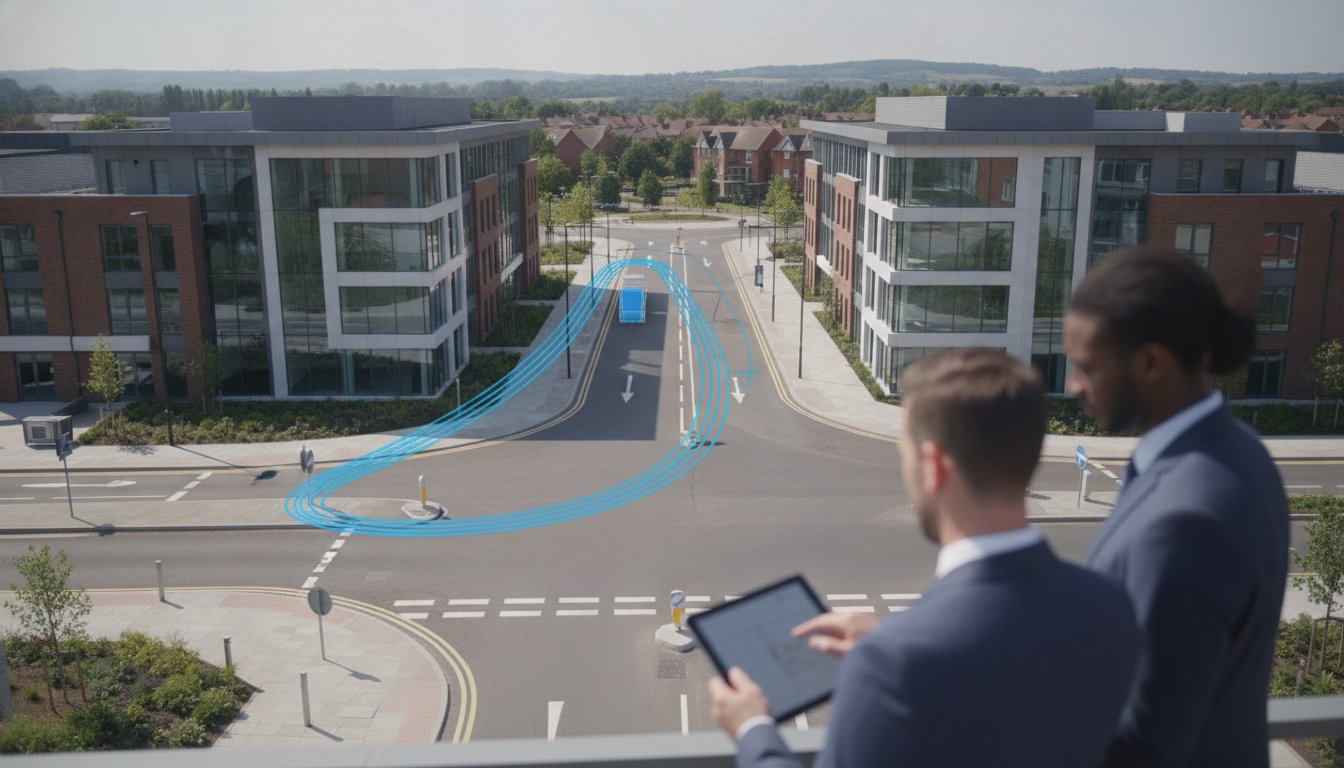
  • Ealing Parking Survey Requirements: A Developer’s Guide to the Lambeth Methodology (2026)

    Ealing Parking Survey Requirements: A Developer’s Guide to the Lambeth Methodology (2026)

    A single percentage point in your parking stress calculation can be the difference between a successful planning approval and a costly refusal in 2026. Developers across West London know that Ealing Council’s shift toward car-free schemes makes local validation more rigorous than ever. It’s frustrating to face project delays simply because your data fails to meet the precise 200 metre walking distance or overnight timing standards required by transport officers.

    This technical guide explains how to navigate the ealing parking survey requirements using the Lambeth Methodology. We’ll help you master the nuances of the 80% stress threshold and the specific 00:30 to 05:30 survey windows to ensure your Transport Statement is audit-ready from the start. You’ll learn how to justify low-parking developments while remaining fully compliant with Ealing’s Climate and Ecological Emergency Strategy. We will cover everything from calculating kerb capacity at five metre intervals to establishing a robust baseline within the first six months of occupation.

    Key Takeaways

    • Understand why Ealing Council mandates the Lambeth Methodology as the framework for assessing on-street parking capacity in 2026.
    • Master the specific ealing parking survey requirements regarding the 200-metre walking distance rule and the critical overnight observation windows.
    • Learn how to calculate parking stress accurately using the standard five-metre vehicle length to ensure data stays below the 80% critical threshold.
    • Identify the essential colour-coding and plotting standards required for an audit-ready mapping submission to council transport officers.
    • Discover how to integrate survey data with a Transport Statement and Swept Path Analysis to justify successful car-free or low-parking schemes.

    What are the Ealing Parking Survey Requirements?

    Ealing Council mandates a clear evidence base for every planning application that changes local demand. Meeting ealing parking survey requirements isn’t just about counting cars; it’s about proving that your project won’t push local infrastructure past its breaking point. The council uses these surveys to determine if the existing kerbside can absorb new residents or visitors without causing safety issues or congestion. This evidence is a non-negotiable part of the planning process for developments ranging from small flat conversions to large-scale commercial hubs. It helps manage the complex relationship between urban planning and parking in London’s dense residential areas. Every survey must measure “parking stress” within a specific catchment area, typically a 200-metre walking distance from the site entrance, to provide a granular view of local capacity during peak demand periods.

    To better understand how these data points are calculated in practice, watch this helpful video:

    The Role of the Lambeth Methodology in Ealing

    Ealing adopts the Lambeth Methodology as its mandatory framework for assessing on-street parking. This approach ensures every survey follows the same rules for calculating capacity. We focus on identifying “legal” parking spaces, which means excluding areas near junctions, over dropped kerbs, or within restricted zones like red routes. Precision is a functional necessity here. If a survey incorrectly identifies restricted kerb space as available, the resulting “parking stress” figure becomes invalid, leading to immediate planning refusal.

    Ealing’s 2026 Planning Climate: Sustainability and Parking

    The 2026 planning climate in Ealing is defined by the borough’s 2030 carbon neutral goal. This strategy impacts how transport officers interpret ealing parking survey requirements for new units. There’s a decisive shift toward car-free developments in high PTAL zones like Ealing Broadway or Acton. Professional data provides the factual rebuttal needed for local objections regarding overspill. By proving stress levels remain below 80%, you can justify “parking-light” schemes in your Transport Statement.

    Securing approval for a development in Ealing requires more than just meeting the minimum standards. It demands a proactive approach to data collection that aligns with the council’s long-term infrastructure goals. Our parking surveys provide the technical authority required to navigate these high-stakes planning environments. We manage the full project lifecycle, from initial site assessment to the final reporting phase, ensuring every detail is compliant with local benchmarks. By providing an all-encompassing service, we reduce the regulatory burden on your team and increase the likelihood of a successful application.

    Technical Standards: The 200m Walkway Rule and Timing

    Precision is a functional necessity when preparing your planning submission. Validation starts at the site entrance, which serves as the central point for all data collection. To meet ealing parking survey requirements, you must define the survey area based on how a person actually walks, not how a crow flies. This is a critical distinction that often determines whether a council transport officer accepts your data or returns it for revision. We manage this process by mapping a 200-metre walkway along the public highway, ensuring every legal parking space is accounted for within a realistic walking distance of the development.

    Walkway vs. Radial Distance: Accuracy in Ealing

    A simple 200-metre radius on a map is insufficient for an audit-ready application. Ealing’s urban landscape is segmented by physical barriers like the Central Line, the Great Western Main Line, and various gated estates. If your 200-metre circle crosses a railway track but the nearest bridge is a ten-minute walk away, that data is technically flawed. The Lambeth Methodology requires a 200-metre walkway that follows the actual pavement route. We use 1:1250 scale OS mapping to verify these distances, which allows us to exclude areas that are physically inaccessible to future residents. This level of detail is vital for justifying car-free schemes in dense areas like West Ealing or Hanwell.

    Survey Timing: Avoiding Anomalous Data

    Timing is everything for residential data. We conduct counts between 00:30 and 05:30 to capture peak residential demand when the highest number of cars are parked overnight. Surveys must occur on two separate weekday nights, typically a Tuesday and Wednesday or a Wednesday and Thursday. Consistency across these two nights is vital to prove that the results aren’t a fluke. We strictly exclude school holidays, bank holidays, and local events such as the Ealing Summer Festivals from our schedules. These periods produce anomalous data that transport officers will quickly identify as non-representative of typical parking stress.

    Recording all parking restrictions is the final technical layer of a compliant survey. This includes identifying Controlled Parking Zone (CPZ) operational hours, permit requirements, and double yellow lines. If you aren’t sure how these restrictions impact your site’s capacity, our team can provide a detailed Parking Survey to clarify your position. By capturing this data accurately, we help you avoid the high costs of repeating surveys during non-representative periods. Our approach ensures your submission is grounded in empirical evidence that stands up to council scrutiny.

    Calculating Parking Stress and Thresholds for Approval

    Parking stress is the core metric that determines the viability of your planning application. It’s expressed as a percentage, calculated by dividing the number of parked vehicles by the total available legal capacity. To meet ealing parking survey requirements, we apply a standard assumption of five metres per vehicle for parallel parking sections. This ensures the capacity calculation is realistic and accounts for the space needed for safe manoeuvring on the public highway. When the data shows stress levels below 80%, council transport officers generally consider the local infrastructure capable of absorbing additional demand.

    Defining “Legal” Kerbside Capacity

    A common pitfall in DIY surveys is overestimating available space. We strictly exclude any sections that aren’t “legal” for overnight parking. This includes junction clearances, where a minimum of 10 metres from any corner is removed from the capacity total to ensure visibility and safety. All dropped kerbs, driveways, and pedestrian crossing points are also excluded. We discount red routes and areas with double yellow lines unless specific overnight exemptions apply.

    In Ealing’s various Controlled Parking Zones (CPZs), we differentiate between Permit Holder bays and Pay & Display spaces. We also account for dedicated disabled bays and car club spaces, as these aren’t available for general residential use. Precision in these exclusions is what makes a report audit-ready. If you include illegal or restricted spaces in your capacity totals, the council will likely reject the entire Transport Statement.

    Mitigation Strategies for High-Stress Results

    If your survey reveals stress levels exceeding 80%, the application enters a “high stress” category. When saturation reaches 90% or more, Ealing Council typically requires significant mitigation to prevent further congestion. One effective strategy is a Section 106 agreement that legally restricts future residents from applying for local CPZ permits. This effectively de-couples the development from local on-street parking demand.

    Integrating a comprehensive Travel Plan is another essential step. This document outlines how the development will encourage sustainable travel through cycle parking, car club memberships, or enhanced EV charging infrastructure. By using empirical data from the survey, we can justify why a car-free scheme is not only viable but necessary for the local area’s sustainability goals. Our technical expertise allows us to frame high-stress results as a catalyst for active travel solutions rather than a reason for refusal. We manage this entire process to ensure your project stays on track for approval.

    Mapping and Presentation: Ealing’s Validation Checklist

    Ealing’s validation process is rigorous, and a simple spreadsheet of numbers is no longer sufficient for a successful planning application. To meet ealing parking survey requirements, your submission must include a high-quality technical map that serves as a visual audit trail for transport officers. We plot each vehicle’s exact position on a 1:1250 scale OS map to show the real-time distribution of occupancy across the survey area. This level of detail allows the council to see exactly where parking stress is concentrated, rather than relying on a vague average across multiple streets. Every report we produce includes a comprehensive street-by-street breakdown of capacity and stress, ensuring total transparency in the data presentation.

    A critical requirement that many developers overlook is the mandatory inclusion of photographic evidence. A compliant report must feature clear photos of every parking restriction sign and time plate within the 200-metre catchment area. This verification proves the surveyor correctly identified the operational hours of the Controlled Parking Zone (CPZ) and the legality of the spaces recorded. Without this evidence, the council may question the accuracy of your capacity totals, leading to unnecessary delays or requests for a re-survey.

    Visualising CPZ Restrictions

    Technical drawings must use distinct colour-coding to separate different types of kerbside use. We clearly distinguish between permit holder bays, shared-use bays, and Pay & Display sections. Single and double yellow lines are mapped with precise start and end points to ensure the “legal” capacity calculation is indisputable. Professionally drafted drawings reduce the logistical pressure on council officers, as they can verify your findings against their own records without ambiguity. If you need an audit-ready report that meets these technical standards, you can book a professional Parking Survey with our team to secure your evidence base.

    Data Integrity and Audit Trails

    Data integrity is the foundation of a defensible planning application. We provide summary tables in both Excel and PDF formats to facilitate easy review by the local highway authority. This structured approach ensures the data remains robust if your project faces scrutiny during the public consultation phase or from local interest groups. Raw data should never be submitted without context; it must be interpreted by a professional traffic engineer who can explain the nuances of the findings. We manage this entire reporting lifecycle to ensure your data is presented as a strategic asset for your application, rather than a liability. Our focus on precision ensures your Transport Statement is grounded in empirical, verifiable facts.

    Securing Permission: Integrating the Survey into Your Application

    A parking survey is not a standalone document; it is a core component of your broader Transport Statement. In 2026, Ealing transport officers look for a cohesive narrative where survey data supports the physical design and operational constraints of the site. For instance, the occupancy levels recorded on the street must align perfectly with your Swept Path Analysis. If your survey identifies heavy overnight parking on a narrow access road, your analysis must prove that refuse and emergency vehicles can still manoeuvre safely past those parked cars. This technical integration is vital for project validation and prevents “parking stress” from becoming a reason for refusal.

    Survey results also provide the empirical weight needed to justify Public Transport Accessibility Level (PTAL) ratings. In areas with high PTAL scores, your data can demonstrate that existing stress levels are manageable, supporting a car-free or low-parking scheme. Conversely, in high-stress areas, the data helps justify permit-free legal agreements that decouple the development from the local kerbside. ML Traffic Engineers UK provides an all-encompassing service that bridges these technical gaps. We ensure your data flows logically from the initial kerbside count to the final planning report, providing a single point of accountability for your transport evidence.

    From Data Collection to Planning Committee

    The transition from raw data to a successful committee vote requires a professional executive summary. Non-technical councillors must understand how your project meets ealing parking survey requirements without wading through hundreds of individual data points. We provide objective evidence to address common resident objections regarding overspill parking, replacing subjective anxiety with factual capacity figures. Engaging in pre-application discussions with this data in hand allows you to agree on the survey scope early. This proactive approach reduces the risk of late-stage revisions and ensures the council is satisfied with the methodology before the final submission.

    Why Professional Consultancy is Non-Negotiable

    Attempting a DIY survey or using non-specialist staff often leads to the “amateur survey” trap. Small errors in timing, walkway mapping, or restriction identification can cause significant planning delays and lead to the refusal of a wider Transport Assessment. Professional consultants understand Ealing’s specific benchmarks and the nuances of the 2026 planning framework. We ensure your application is audit-ready and technically sound from day one. Ready for a quote? Contact ML Traffic Engineers UK today to secure expert support for your next Ealing development.

    Secure Your Planning Approval with Audit-Ready Data

    Successfully meeting ealing parking survey requirements in 2026 demands absolute technical precision. You’ve seen how the 200-metre walkway rule and the 80% parking stress threshold act as the primary benchmarks for council transport officers. By integrating this data with a robust Transport Statement and Swept Path Analysis, you transform a simple survey into a strategic asset that supports your development’s viability. Precision is a functional necessity in these high-stakes environments, and professional data is your best defence against project delays.

    We’ve been specialists in London transport planning since 2014, providing the technical authority needed to navigate complex regional regulations. Our reports guarantee full Lambeth Methodology compliance, ensuring your data is defensible during public consultation and planning committee reviews. We provide an all-encompassing service that manages the logistical pressures of data collection so you don’t have to. Our team is ready to act as the guardian of your application’s transport evidence.

    Ready to move forward? Request a Professional Parking Survey Quote for Your Ealing Project today to ensure your submission is compliant from the start. With the right data and expert support, your project is well-positioned for a successful outcome.

    Frequently Asked Questions

    Why does Ealing Council require the Lambeth Methodology?

    Ealing Council mandates the Lambeth Methodology because it provides a standardized framework for calculating kerbside capacity and occupancy. This London-wide standard ensures consistency across all planning applications, allowing transport officers to compare data accurately. By using a uniform formula, the council can objectively assess whether a new development will push local parking stress beyond acceptable limits.

    What is the 200m walkway rule in an Ealing parking survey?

    The 200-metre walkway rule requires surveyors to measure the distance along actual pedestrian paths from the site entrance rather than using a simple radius. This is a critical part of ealing parking survey requirements because it accounts for physical barriers like the Central Line or the A406. It ensures the survey area only includes parking spaces that are realistically accessible to future residents.

    Can I do my own parking survey for a planning application?

    The council typically rejects self-conducted surveys due to potential bias and the lack of professional technical oversight. Transport officers require independent, empirical data collected by qualified traffic engineers to validate a Transport Statement. Using a professional consultant ensures the report is audit-ready and follows the strict Lambeth standards required for a successful planning committee review.

    What happens if the survey shows 100% parking stress?

    If a survey shows 100% parking stress, the local kerbside is considered fully saturated. In these scenarios, Ealing Council usually requires the development to be car-free through a Section 106 legal agreement. This prevents future residents from obtaining local parking permits. Developers must then use the survey data to justify how active travel and cycle infrastructure will mitigate any additional transport impact.

    How many nights of surveying are required in Ealing?

    Ealing Council requires surveys to be conducted over two separate weekday nights to establish a reliable baseline of residential demand. These counts typically take place between 00:30 and 05:30 on a Tuesday and Wednesday or a Wednesday and Thursday. Surveying across multiple nights ensures the results aren’t skewed by one-off local events or unusual parking activity on a single evening.

    Can I conduct a parking survey during the school holidays?

    No, surveys conducted during school holidays, bank holidays, or major local events are considered non-representative and will likely be rejected. These periods don’t reflect typical residential parking patterns in the borough. To meet ealing parking survey requirements, you must schedule data collection during neutral weeks when local schools and businesses are operating at their normal capacity.

    How long is a Lambeth parking survey valid for in London?

    A parking survey is generally considered valid for six to twelve months from the date of the original count. If your planning application is delayed beyond this period, the local highway authority may request a fresh survey to reflect current demand. It’s essential to coordinate your data collection with your overall project timeline to avoid the high costs of repeating the process.

    Do I need a survey for a car-free development in Ealing?

    Yes, even car-free schemes often require a survey to prove they won’t cause overspill parking on surrounding residential streets. The data demonstrates that the existing kerbside can absorb incidental demand from visitors, deliveries, or residents who may still own vehicles despite permit restrictions. This objective evidence is vital for addressing community objections and securing approval from the planning committee.

    Michael Lee

    Article by

    Michael Lee

    Transport planner with over 35 years' experience.

    Disclaimer

    The content on mltraffic.co.uk, including all technical articles, guides, and resources, is provided for general informational and educational purposes only. It is not intended to constitute professional advice in traffic engineering, transportation planning, development approvals, or any other technical or legal field.
    While ML Traffic Engineers makes every reasonable effort to ensure the accuracy, completeness, and timeliness of the information published, we do not provide any warranties or representations (express or implied) regarding its reliability, suitability, or availability for any particular purpose. Any reliance you place on the content is strictly at your own risk.
    In no event shall ML Traffic Engineers, its directors, employees, authors, or affiliates be liable for any direct, indirect, incidental, special, consequential, or punitive damages (including, without limitation, loss of profits, data, or business opportunities) arising out of or in connection with the use of, or inability to use, any information provided on this website.
    The articles and guides on this site are not a substitute for engaging a qualified, professional traffic engineer to assess your specific project requirements. For tailored advice, compliance assessments, or traffic engineering services, please contact a competent professional.
    This disclaimer may be updated from time to time without notice. By accessing or using this website, you agree to be bound by the most current version of this disclaimer.
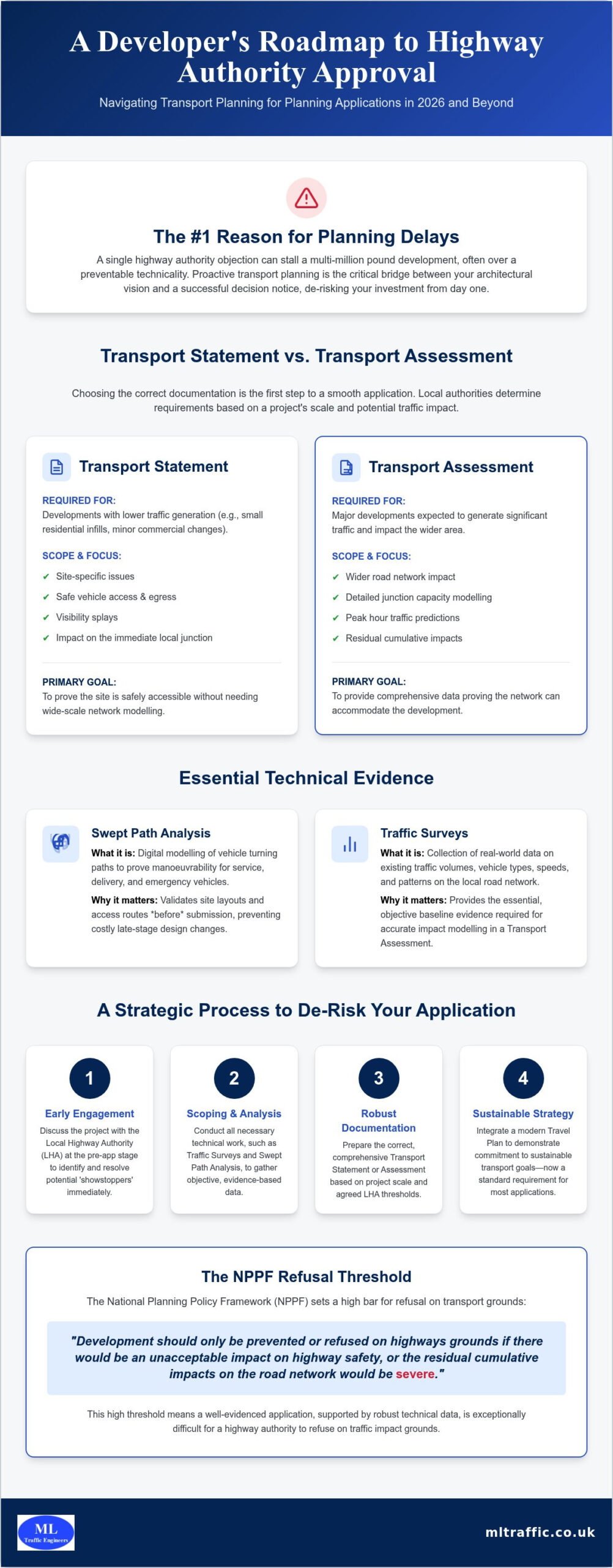
  • Transport Assessment: 2026 Residential Developer’s Guide

    Transport Assessment: 2026 Residential Developer’s Guide

    Did you know that 42% of minor development applications in London face immediate delays at the validation stage because of insufficient highway data? For a residential developer, these technical hurdles represent more than just paperwork. They are often the primary cause of stalled timelines and unexpected costs from off-site highway works. Securing a robust transport assessment for residential development is no longer just a box-ticking exercise. It’s a critical strategic tool used to preempt council objections through data-driven precision.

    We understand that the confusion between Transport Statements and full Assessments, combined with the 2026 shift toward a vision-led planning approach, creates significant regulatory pressure. This guide provides the technical clarity you need to master these requirements and secure planning approval with confidence. You’ll learn how to navigate the latest NPPF revisions, manage 100% EV charging mandates, and ensure your highway mitigation remains cost-effective. We’ll examine the specific evidence required to satisfy local authorities and keep your project moving from inception to completion.

    Key Takeaways

    • Utilize TRICS data and Swept Path Analysis to provide technical proof that your site can safely accommodate emergency and refuse vehicle movements.
    • Distinguish between a Transport Statement and a full Assessment to ensure your submission is proportionate to your project’s scale and avoids unnecessary modelling costs.
    • Align your site design with Active Travel England standards and Vision Zero principles to satisfy the 2026 shift toward sustainable transport infrastructure.
    • Secure a robust transport assessment for residential development to act as a strategic negotiation tool that preempts highway objections and reduces project risk.
    • Engage with expert Travel Plan Consultants early to implement effective car-reduction strategies that strengthen the sustainability profile of your planning application.

    What is a Transport Assessment for Residential Development?

    A transport assessment for residential development is a comprehensive technical document required by planning authorities to evaluate the impact of new housing on the existing highway network. It serves as a piece of the wider transportation planning process, acting as the bridge between your architectural vision and the functional reality of local infrastructure. Unlike a generic traffic report, this document uses empirical data to forecast how future residents will move. It ensures that the local area can absorb additional demand without compromising public safety or network efficiency.

    The legal foundation for these reports rests on the National Planning Policy Framework (NPPF). As of the Summer 2026 revisions, the framework has shifted from a “predict and provide” model to a “vision-led” approach. This change requires developers to define desired place-making outcomes first, rather than simply reacting to traffic forecasts. Residential projects face unique scrutiny compared to industrial or commercial sites. While a warehouse focuses on heavy goods vehicle timing, a housing development must account for complex multi-modal patterns. This includes school run peaks, grocery deliveries, and pedestrian safety for vulnerable road users.

    The Local Highway Authority (LHA) acts as the primary guardian of these standards. They review your submission to ensure that your project doesn’t just “fit” the road but actively contributes to its long-term viability. Their feedback can make or break an application, which is why precision in your initial data is a functional necessity for securing planning permission.

    The Threshold: When do you need a full Assessment?

    Differentiating between a small-scale site and a major development is the first step in your planning strategy. In many regions, including most London boroughs, schemes under 50 units usually require a Transport Statement. This is a lighter, more concise report focused on immediate site access. However, once a project exceeds 80 dwellings, a full Assessment becomes mandatory. Local authority variations exist, so checking the specific Local Validation List for your borough is essential to avoid immediate validation delays at the start of the project lifecycle.

    Core Objectives of a Successful Assessment

    A successful assessment must prove three specific points to the LHA. First, it must demonstrate safe and suitable access for all users, including those with mobility impairments. Second, it must show that any “residual cumulative impact” on the road network isn’t severe. Finally, it must promote sustainable travel. By integrating a robust Travel Plan, you can reduce car dependency and satisfy the strict 2026 environmental benchmarks that councils now prioritize.

    The Technical Engine: Data and Analysis Requirements

    A transport assessment for residential development relies on a technical engine of precise, empirical data. Without accurate modeling, even the most sustainable architectural designs can fail at the planning stage. We prioritize high-resolution data to ensure your project meets both local highway authority standards and international sustainability goals for reduced carbon impact. Precision here isn’t just about compliance. It’s about protecting your project from the 42% of applications that face immediate delays due to insufficient highway evidence.

    Technical reporting must go beyond surface-level observations. It requires a rigorous combination of trip generation modeling, vehicle movement simulations, and real-world surveys. This data counters outdated council records and provides a factual basis for your development’s impact. Our team provides the technical analysis required to satisfy these rigorous council standards.

    TRICS Trip Generation for Residential Sites

    We use the 2026 TRICS database to predict how many vehicle and pedestrian trips your site will generate. Selecting comparable sites is the most critical part of this process. A site in a high-density urban area with a PTAL score of 5 behaves differently than a rural development. We analyze peak hour data for both morning and evening commutes to ensure the network can handle the highest levels of demand. This multi-modal approach accounts for the 80% sustainable trip target set by the London Plan, shifting the focus from cars to active travel.

    Swept Path Analysis (SPA) and Site Layout

    Ensuring that fire tenders and refuse trucks can navigate your estate is a non-negotiable safety requirement. We utilize Swept Path Analysis to simulate these movements during the early design stages. This prevents costly redesigns after you’ve already committed to a layout. With light van movements increasing by 30% in urban centers, your site must accommodate frequent delivery vehicles without blocking emergency access routes. Integrating SPA into your car park design ensures every turn and junction is functionally safe and compliant with Building Regulations Part S.

    Parking surveys provide the final layer of technical defense. As of 2026, 100% of new residential parking spaces must include EV charging infrastructure. We conduct parking stress surveys to justify “low-car” or car-free developments in high-accessibility areas. This data-led approach proves to local authorities that your parking provision is sufficient, sustainable, and safe.

    Transport Statement vs. Assessment: Which One Do You Need?

    Choosing the wrong technical document is a primary cause of planning delays and unnecessary expenditure. A transport assessment for residential development is required when a project’s impact is significant, while a Transport Statement suffices for smaller schemes with lower traffic implications. The UK government guidance on Transport Assessments emphasizes that these documents must be proportionate to the scale of the development. However, the line between the two isn’t always determined by unit count alone. It’s often defined by the existing capacity of the local highway network.

    Under-reporting is a major risk that leads to immediate friction with local authorities. If you submit a Statement for a site that the council deems “sensitive,” they will likely reject the application or demand a full upgrade mid-process. Approximately 15% of London applications face deferral due to insufficient transport evidence. This results in wasted technical fees and months of project stagnation. Budgeting for the correct level of consultancy from the start is more cost-effective than attempting to “downgrade” a report that requires more technical weight to pass the validation stage.

    Key Differences in Scope and Detail

    A full Assessment requires detailed junction capacity modelling using specialized software like Junctions 9 or 10. This analysis tests how specific junctions perform under peak pressure and predicts the cumulative impact of your development alongside other local projects. Statements rarely require this level of complex simulation. Both documents now require a high depth of sustainable transport analysis to meet 2026 standards, focusing on pedestrian and cycle connectivity. For a detailed breakdown of costs and requirements for smaller sites, see our Developer’s Buying Guide for Transport Statements.

    Decision Factors for Developers

    Site location and surrounding infrastructure often dictate the report type more than unit numbers alone. A 40-unit scheme in a rural area might trigger a full transport assessment for residential development if the local road network is already at capacity or has a poor safety record. Identifying “sensitive” highway areas is a functional necessity. These include sites near schools, hospitals, or within Air Quality Management Areas (AQMAs) where any increase in traffic is heavily scrutinized. We always recommend securing pre-application advice from the Local Highway Authority (LHA). This “scoping” exercise confirms the exact level of detail and the specific junctions that need testing before you commit to technical work.

    Securing planning permission in 2026 requires more than just technical data. It requires a deep understanding of the policy shift toward Vision Zero and Active Travel England standards. Local authorities now prioritize the safety of vulnerable road users and the quality of the pedestrian environment over vehicle throughput. Your transport assessment for residential development must reflect these priorities to avoid immediate pushback. We take an active approach to these regulations, ensuring your project meets the latest legislative benchmarks from the first day. This includes aligning with the “Healthy Streets” approach and the goal of eliminating all transport-related deaths by 2041.

    Specific regions present unique challenges. For example, Transport Planning in London involves mandatory oversight from TfL for any site within 100 metres of a red route. These applications often trigger Section 106 financial contributions for public transport improvements or Section 278 agreements for physical highway modifications. Navigating these negotiations requires a reliable partner who understands regional variations so you don’t have to. We manage the full project lifecycle, from initial scoping to the final highway works agreement, ensuring you remain compliant with the London Plan’s strict parking mandates.

    The 5-Step Roadmap to Approval

    We follow a logical, sequential flow to ensure your application remains on track. This systematic approach reduces logistical pressure and minimizes the risk of technical objections during the validation stage.

    • Step 1: Scoping. We agree on the assessment’s scope with the Local Highway Authority early. This prevents redundant work and ensures we test the correct junctions.
    • Step 2: Data Collection. Our teams conduct parking and traffic surveys to build a factual evidence base that counters outdated council records.
    • Step 3: Technical Modelling. We perform impact analysis to predict future network performance and justify your site’s access strategy.
    • Step 4: Mitigation Strategy. We develop robust Travel Plans and highway works to offset any identified impacts and promote sustainable travel.
    • Step 5: Negotiation. We manage post-submission queries from planning officers to keep your timeline moving and reach a successful decision.

    Common Objections and How to Preempt Them

    Council objections often focus on three areas: parking provision, pedestrian safety, and local congestion. If a council objects to a “car-free” design, we use parking stress surveys to justify the provision level based on the site’s PTAL score. When pedestrian links are deemed inadequate, we propose sustainable infrastructure improvements as part of the mitigation strategy. For congestion concerns, we use precise junction modelling to prove that the residual cumulative impact is not severe. This data-led precision is your best defense against planning delays.

    Don’t let regulatory hurdles stall your project. Contact our technical team today to secure a compliant transport assessment for residential development.

    Why Expert Consultancy is Vital for Residential Success

    A transport assessment for residential development represents more than a data set; it’s a strategic negotiation document. Professional Travel Plan Consultants provide the necessary foresight to reduce car dependency and meet the high sustainability expectations of 2026 planning committees. This expertise ensures your scheme remains functional while satisfying the strict legislative benchmarks that define modern housing projects. Technical precision is a functional necessity in this high-stakes environment, where even minor data gaps can lead to costly delays.

    ML Traffic Engineers UK acts as a dependable partner throughout the full project lifecycle. Since our inception in 2014, we’ve focused on delivering technical authority with a client-focused approach. We understand the logistical and regulatory pressures that developers face during the planning phase. Our team manages every technical detail from initial site scoping to post-submission negotiations. This comprehensive support ensures your project adheres to industry benchmarks without unnecessary delays. By identifying potential highway objections before they reach the council, we protect your investment and reduce project risk.

    Beyond the Report: Strategic Planning Support

    Expert consultants provide a reassuring voice in high-stakes environments. We represent developers in technical meetings with highway officers to defend the data and the proposed access strategy. We utilize a technical lexicon rooted in regulatory compliance to communicate effectively with planning authorities. This ensures that technical arguments for specific junction designs are framed in a way that planning officers can readily accept. We also advise on site layout early in the process to maximize developable area while ensuring every road and junction meets safety standards. This proactive involvement prevents the technical bottlenecks that often stall residential applications during the consultation period.

    Efficiency and Reliability

    The fast-moving nature of the infrastructure sector requires a partner with constant accessibility. ML Traffic Engineers UK maintains a sense of readiness and urgency to ensure your project stays on schedule. Our deep understanding of regional regulations across England and London allows us to provide a fully-managed service that addresses intricate local requirements. We take pride in our adherence to standards and our role as professional guardians of public safety. This rhythmic efficiency suggests a brand that values your time and understands the unpredictable nature of planning timelines.

    Contact ML Traffic Engineers UK for a tailored Transport Assessment quote to secure your project’s success with a robust transport assessment for residential development.

    Secure Your Planning Approval with Technical Precision

    The 2026 planning landscape demands a transition from traditional traffic forecasting to a vision-led, outcome-focused methodology. By prioritizing sustainable movement and high-resolution data, you address the core concerns of the Local Highway Authority before they result in application deferrals. A robust transport assessment for residential development is no longer just a technical requirement; it’s your strongest asset in negotiating complex planning conditions and minimizing off-site highway costs. This strategic approach ensures your site remains both compliant with the latest NPPF revisions and commercially viable.

    Since 2014, ML Traffic Engineers UK has provided the specialized technical authority needed to navigate these high-stakes regulatory environments. Our all-encompassing service manages the full project lifecycle, offering expertise in TRICS modeling and Swept Path Analysis from initial scoping through to final approval. We understand the urgency of housing delivery and maintain a constant readiness to prevent technical bottlenecks in your timeline. Get a Professional Transport Assessment for Your Residential Project and partner with an expert team dedicated to precision, safety, and your project’s success. We look forward to securing the planning results your development deserves.

    Frequently Asked Questions

    Do I need a Transport Assessment for a small residential conversion?

    Most small conversions involving fewer than 50 units only require a Transport Statement rather than a full Assessment. However, if your project is located in a sensitive area or has complex access issues, the council may request a more detailed report. You should always consult the local authority’s validation list to confirm the specific requirements for your site location.

    How long does it take to complete a Transport Assessment for a housing development?

    A standard assessment typically takes between three to six weeks to complete. This timeframe includes essential site observations, data collection from the TRICS database, and technical modeling of local junctions. More complex projects that require extensive negotiation with highway officers or Transport for London (TfL) may take longer to reach the final submission stage.

    What is the difference between a Transport Assessment and a Travel Plan?

    A Transport Assessment evaluates the physical impact of a development on the highway network, while a Travel Plan is a strategic document designed to manage and reduce that impact. The Assessment focuses on infrastructure capacity and safety. In contrast, the Travel Plan promotes sustainable travel habits, such as cycling and public transport use, among future residents.

    Can a Transport Assessment help reduce my Section 106 contributions?

    A robust transport assessment for residential development can justify lower financial contributions by providing empirical proof that the project’s impact is less severe than predicted. Accurate modeling can demonstrate that your on-site mitigations are sufficient to handle the new demand. This technical evidence often prevents developers from being overcharged for unnecessary off-site highway works.

    What happens if the local council objects to my Transport Assessment?

    We immediately engage in technical negotiations with highway officers to address their specific concerns. This process often involves providing additional data or refining the proposed mitigation strategy to satisfy safety standards. Our team defends the precision of the original report while finding a functional solution that allows the project to move forward toward approval.

    Is Swept Path Analysis always required for residential planning?

    Most residential applications require Swept Path Analysis to prove that fire tenders and refuse trucks can safely navigate the proposed site layout. Councils prioritize emergency access and service vehicle movements as non-negotiable safety benchmarks. Providing this visual evidence early in the design stage prevents costly layout revisions and ensures your application meets mandatory Building Regulations.

    How much does a Transport Assessment cost for a UK residential project?

    The cost of an assessment depends on the scale of the development and the complexity of the required junction modeling. Factors such as the number of sites to be surveyed and the specific requirements of the local highway authority will influence the total fee. Developers should seek a tailored quote that reflects the unique technical demands of their specific residential scheme.

    What is TRICS data and why is it used in residential planning?

    TRICS is the industry-standard database used to predict trip generation for new developments by analyzing surveys from comparable existing sites. It provides the factual foundation needed to forecast vehicle and pedestrian movements accurately. Using the latest TRICS data is essential for producing a compliant transport assessment for residential development that stands up to council scrutiny.

    Michael Lee

    Article by

    Michael Lee

    Transport planner with over 35 years' experience.

    Disclaimer

    The content on mltraffic.co.uk, including all technical articles, guides, and resources, is provided for general informational and educational purposes only. It is not intended to constitute professional advice in traffic engineering, transportation planning, development approvals, or any other technical or legal field.
    While ML Traffic Engineers makes every reasonable effort to ensure the accuracy, completeness, and timeliness of the information published, we do not provide any warranties or representations (express or implied) regarding its reliability, suitability, or availability for any particular purpose. Any reliance you place on the content is strictly at your own risk.
    In no event shall ML Traffic Engineers, its directors, employees, authors, or affiliates be liable for any direct, indirect, incidental, special, consequential, or punitive damages (including, without limitation, loss of profits, data, or business opportunities) arising out of or in connection with the use of, or inability to use, any information provided on this website.
    The articles and guides on this site are not a substitute for engaging a qualified, professional traffic engineer to assess your specific project requirements. For tailored advice, compliance assessments, or traffic engineering services, please contact a competent professional.
    This disclaimer may be updated from time to time without notice. By accessing or using this website, you agree to be bound by the most current version of this disclaimer.
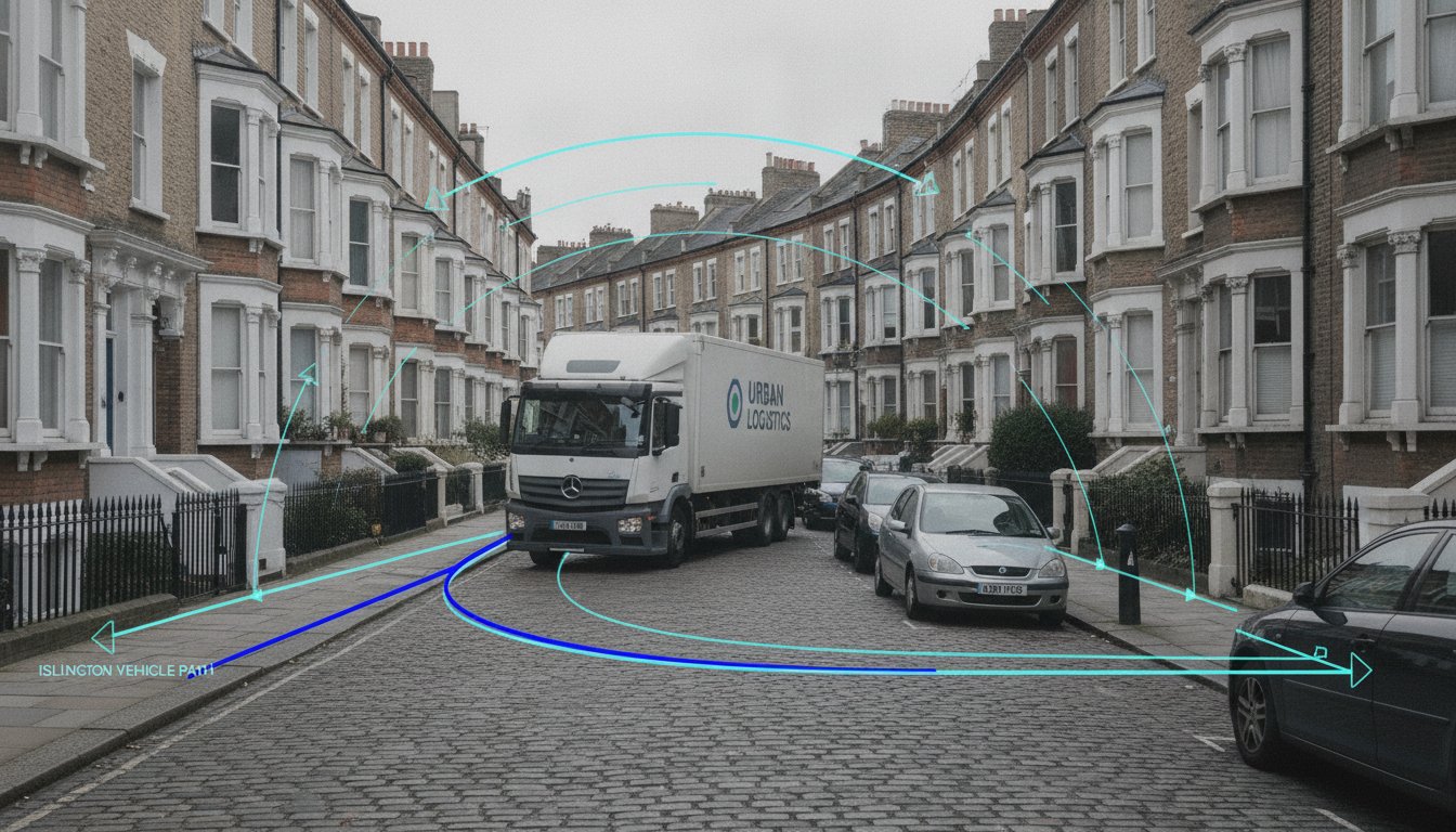
  • Junction Capacity Assessment: A Developer’s Guide to UK Planning Success in 2026

    Junction Capacity Assessment: A Developer’s Guide to UK Planning Success in 2026

    Did you know that a failed technical audit for a highway submission in London can delay your development by as much as 24 weeks? For many UK developers, the technical complexity of a junction capacity assessment feels like a barrier designed to trigger objections rather than facilitate growth. It’s common to feel overwhelmed by the threat of planning refusal or the high costs of unnecessary road mitigation schemes demanded by local authorities. You want to move forward, but conservative council estimates often stand in the way of your project’s viability.

    This guide will help you master the technical requirements of modern modelling to overcome highway objections and secure planning approval for your UK development. We’ll show you how to use the latest software, such as Junctions 11.2.0 and LinSig 3.3.2.0, to challenge assumptions and present a robust case to planning committees. We’ll provide a clear breakdown of RFC and degree of saturation results, ensuring you understand exactly how to navigate 2026 regulatory standards. From interpreting traffic survey data to implementing cost-effective mitigation strategies, you’ll gain the technical authority needed to manage your project’s lifecycle with confidence and precision.

    Key Takeaways

    • Understand how a professional junction capacity assessment satisfies NPPF requirements and prevents planning refusal by proving your development doesn’t cause ‘severe’ cumulative impact.
    • Identify the correct modelling software for your specific project, from ARCADY for roundabouts to PICADY for priority junctions, to ensure technical data accuracy.
    • Learn to interpret critical metrics like the 0.85 RFC threshold and MMQ to understand how Highway Authorities evaluate your project’s operational stability.
    • Discover how precise modelling streamlines the transition from planning approval to S278 and S38 legal agreements for highway design works.
    • Gain strategies for identifying cost-effective mitigation options that satisfy council requirements without over-engineering your road infrastructure.

    What is a Junction Capacity Assessment and Why is it Critical in 2026?

    A junction capacity assessment is a rigorous technical evaluation that measures how vehicle flow interacts with the physical constraints of a road intersection. It’s the primary tool used to determine whether existing infrastructure can handle the additional traffic generated by a new development. In 2026, this isn’t just about counting cars. It’s about precision. We focus on “residual capacity,” which is the remaining space on the network after existing traffic is accounted for, to ensure your project doesn’t push the local roads past their breaking point.

    This technical study is your strongest defence against planning refusal. Under Paragraph 115 of the National Planning Policy Framework (NPPF), development should only be prevented or refused on highways grounds if there’s an unacceptable impact on highway safety, or the cumulative impacts on the road network would be “severe.” Without a robust junction capacity assessment, “severe” is a subjective term that local authorities might use to block your application. Our job is to provide the data that turns that subjective opinion into a technical negotiation.

    Modern planning standards require more granular data than ever before. The rapid uptake of Electric Vehicles (EVs) and changing urban mobility patterns mean older traffic models are often inaccurate. Modern assessments must account for different acceleration profiles and the increased presence of active travel lanes. By using Industry-Standard Modelling Software, we ensure your data reflects the reality of 2026 road usage, not the outdated metrics of a decade ago.

    To better understand how vehicle flow is managed at intersections, watch this helpful video:

    When Does a Developer Need a Formal Capacity Study?

    The requirement for a study usually depends on the scale of the project. Larger developments typically require a full Transport Assessment, while smaller sites might only need a Transport Statement. However, even small projects can trigger a mandatory assessment if the Local Highway Authority identifies “sensitive” junctions nearby that are already approaching their physical limits. Your site access design often dictates whether you need to model the wider network or just the immediate entrance.

    The Commercial Risk of Ignoring Junction Modelling

    Ignoring the need for early modelling creates significant commercial risk. Poorly executed data often leads to “Grampian” conditions. These are planning conditions that prevent development from starting until specific off-site highway works are completed. Such delays can stall your project for months and inflate your preliminary costs. Furthermore, conservative council estimates often result in over-designed junctions. Accurate modelling allows you to present a data-driven case that protects your profit margins by avoiding excessive Section 106 contributions for unnecessary road improvements.

    Industry-Standard Modelling Software: ARCADY, PICADY, and LinSig

    Selecting the right tools ensures your junction capacity assessment withstands scrutiny. Local Highway Authorities expect models built on industry-standard platforms that reflect the latest 2026 updates. We utilize several specialized tools depending on the junction type and the complexity of the surrounding network:

    • ARCADY: This module within the Junctions 11.2.0 suite is the essential tool for circular junctions. It calculates capacity and delay by analysing geometry like entry width and flare length.
    • PICADY: Designed for T-junctions or staggered crossroads, PICADY is the technical benchmark for priority-controlled intersections.
    • LinSig 3.3.2.0: We use this for signal-controlled junctions to model traffic lights and urban networks, accounting for signal timings, lane saturation, and pedestrian phases.
    • VISSIM: When static models aren’t enough for high-density city centres, micro-simulation provides a dynamic, vehicle-by-vehicle analysis of the network.

    This level of technical detail is often necessary for UK Planning Success in complex urban corridors where multi-modal traffic is the norm. By choosing the correct software, we demonstrate a precise understanding of how your development interacts with existing infrastructure.

    Data Inputs: Garbage In, Garbage Out

    A model is only as reliable as the data driving it. We build every junction capacity assessment on a foundation of accurate Traffic Surveys. We use Automatic Traffic Counters (ATC) for long-term flow data and Manual Classified Counts (MCC) to capture specific vehicle types at peak times. In 2026, capturing the correct vehicle mix is vital due to the shift toward electric delivery fleets and cycle lane integration. We then apply growth factors from TEMPro and the National Road Traffic Forecasts (NRTF) to predict future demand. We also integrate Swept Path Analysis into the process. This ensures the model’s physical dimensions match the actual turning capabilities of HGVs and emergency vehicles, preventing technical objections later.

    Modelling Scenarios: Base Year vs. Future Year

    Highway Authorities require multiple scenarios to test resilience. First, we develop a ‘Base Year’ model. This must accurately reflect current on-street reality to gain technical approval. Once validated, we create ‘Opening Year’ and ‘Horizon Year’ scenarios, usually looking five or ten years ahead. We test both AM and PM peak hours to identify the ‘worst-case’ impact scenario for your development. This comprehensive approach ensures your planning application is robust against challenges. If you need assistance with these complex requirements, our team can provide a tailored Transport Assessment to support your project and reduce regulatory pressure.

    Interpreting Results: Understanding RFC, MMQ, and Delay

    Interpreting the output of a junction capacity assessment requires moving beyond raw numbers to understand operational stability. Once the modelling software processes the survey data, it generates several key metrics that Highway Authorities use to judge your application. The primary metric we focus on is the Ratio of Flow to Capacity (RFC). While a junction technically has capacity up to a value of 1.0, anything above 0.85 suggests the junction is starting to struggle with peak fluctuations. This is the point where queues become non-linear and unpredictable.

    Beyond RFC, we analyze the Mean Maximum Queue (MMQ). This metric visualizes the physical length of the queue in “passenger car units” (PCUs) during peak periods. It’s vital for ensuring that traffic from your site doesn’t “tail back” and block adjacent intersections or pedestrian crossings. We also measure delay per vehicle, which quantifies the average waiting time in seconds. For signalized junctions, we switch to the Degree of Saturation (DoS), where we aim for a result below 90%. This framework is a core component of the wider What is a Junction Capacity Assessment process that local authorities use to evaluate development impact.

    What Happens When the Model ‘Fails’?

    A “failed” model doesn’t always lead to planning refusal. We distinguish between a junction that’s simply “at capacity” and one that’s “over capacity.” If the existing road network is already performing poorly, we often utilize the “Nil Detriment” principle. This involves proving that the development’s additional traffic doesn’t make the existing situation significantly worse. Since a 2026 survey found that 71% of councils still categorize roads based on traffic flow rather than modern “Movement and Place” concepts, they often strictly enforce these thresholds. The Ratio of Flow to Capacity (RFC) is an industry-standard metric where a value of 0.85 or lower indicates that a junction is operating within its practical capacity and remains stable during peak fluctuations.

    Mitigation Strategies for Failing Junctions

    When a junction capacity assessment identifies a genuine capacity issue, we look for cost-effective mitigation rather than expensive road reconstruction. Physical improvements like flare extensions, signal optimization, or lane re-allocation can often provide the necessary residual capacity. We also prioritize demand management. Implementing a robust Travel Plan reduces peak vehicle trips by encouraging sustainable transport modes. If physical or demand-side changes aren’t enough, we might propose strategic site access changes to redistribute the traffic load across multiple junctions, preventing any single point from becoming a bottleneck that stalls your planning success.

    Junction Capacity Assessment: A Developer’s Guide to UK Planning Success in 2026

    From Modelling to Construction: S278 and S38 Integration

    The transition from a successful planning application to actual construction depends on the technical integrity of your junction capacity assessment. While the model secures the initial “resolution to grant,” it also serves as the technical blueprint for Highway Design S278 works. Highway Authorities scrutinise these models during the Technical Approval (TA) phase with extreme rigour. They must ensure that the physical design, such as lane widths or signal timings, matches the performance predicted in the capacity study before they sign off on legal agreements.

    There’s a direct link between your capacity results and the cost of the S278 bond. If a model suggests a junction is nearing capacity, authorities may demand wider lanes or longer flares. This increases the scale of works and, consequently, the financial bond you must provide. For instance, Cornwall Council’s Highways Agreement fee was updated in April 2026 to 8.75% of the works cost. Precise modelling ensures you aren’t paying for over-engineered infrastructure based on conservative assumptions. We design for 2026 standards while accounting for future autonomous vehicle patterns to ensure your investment remains viable for decades. For those looking to ensure on-site precision during these works, you can explore Construction Layout options that align civil engineering data with real-world construction.

    Negotiating with Local Highway Authorities

    Negotiations with bodies like Transport for London (TfL) or County Councils often centre on model “validation.” Authorities frequently challenge trip rates or junction geometry to ensure the model reflects real-world congestion. Professional representation is vital during these pre-application meetings to defend your data. We use sensitivity testing to challenge overly conservative “background growth” assumptions that often stall projects. By proving that the local network can handle the load without excessive widening, we protect your project’s bottom line from unnecessary infrastructure costs.

    While technical data is used to protect a project’s viability, strategic brand communication is equally important for firms in the engineering and technology sectors; BCM Public Relations provides the specialist B2B media relations support required to effectively manage industry reputation and professional profile.

    The Role of the Transport Assessment

    We synthesise all junction results into a comprehensive Transport Assessment that speaks to both technical auditors and Planning Committee members. It’s not enough to have a stable RFC; you must present the data in a way that non-technical stakeholders can understand. This means clearly explaining how the development aligns with local “Vision Zero” safety goals and active travel policies. If you need a partner who can manage the full project lifecycle from initial survey to technical sign-off, our team provides the specialist traffic engineering support required to secure your Section 278 agreement.

    Why Choose ML Traffic Engineers UK for Your Capacity Assessment?

    ML Traffic Engineers UK understands that a junction capacity assessment is more than just a data set; it’s a vital component of your project’s commercial viability. Since our founding in 2014, we’ve focused on delivering precision-led documentation that withstands the most rigorous scrutiny from Local Highway Authorities. We take immense pride in our role as a dependable partner, ensuring your development meets all statutory requirements while minimizing logistical pressures. Our team maintains a constant sense of readiness to respond to the fast-moving and often unpredictable nature of UK infrastructure planning.

    We adopt a developer-focused mentality that prioritizes your bottom line. Many consultants propose mitigation schemes that are easiest for the Council to approve, often resulting in unnecessary and expensive road construction. We do the opposite. We use the latest industry software to identify the most cost-effective mitigation strategies, ensuring you don’t pay for over-engineered road works. Our track record across London Boroughs and UK County Councils proves that accurate modelling is the best way to protect your profit margins against conservative background growth assumptions.

    Our Technical Toolkit

    Our technical toolkit includes mastery of the Junctions 11.2.0 suite (ARCADY and PICADY), LinSig 3.3.2.0, and AutoTurn. We provide an integrated service where Swept Path Analysis and capacity work happen simultaneously. Because we conduct our own Traffic Surveys, we guarantee the integrity of the foundation data and eliminate the risk of third-party errors. ML Traffic Engineers UK manages full project lifecycles from initial inception through to the final sign-off of S278 technical agreements. This all-encompassing service ensures your junction capacity assessment remains robust under the technical audits required by authorities like Transport for London or various County Councils.

    Get Started on Your Assessment

    Early engagement prevents costly delays and identifies highway “showstoppers” before you commit significant capital. We understand the intricate regional regulations that vary between authorities, so you don’t have to. When you contact us for a quote, please provide your site location, proposed land use, and existing access details. This allows our team to provide a tailored, sequential plan for your Transport Assessment or statement. Our rhythmic efficiency and commitment to standards ensure your project moves from planning to execution without unnecessary friction. Contact ML Traffic Engineers UK for a professional junction capacity review today.

    Secure Your Planning Approval with Technical Precision

    A robust junction capacity assessment is the cornerstone of any successful planning application in 2026. By mastering technical metrics like RFC and utilizing industry-standard software, you transform highway objections into manageable technical negotiations. Accurate modelling doesn’t just satisfy Local Highway Authorities; it protects your project from the high costs of over-engineered infrastructure and unnecessary Section 278 bond increases. Precision in the early stages ensures a clear path through the complex regulatory landscape of modern UK infrastructure. Furthermore, as designs become more complex, specialized training from White Plains Driving Center ensures that drivers have the highway practice needed to navigate these environments safely.

    Our team brings specialized expertise in ARCADY, PICADY, and LinSig to every project. We maintain a proven track record of success across UK Planning Authorities, supported by our integrated Swept Path Analysis and Traffic Survey capabilities. We manage the entire technical lifecycle so you don’t have to worry about regulatory pressure. Secure your planning approval with expert junction modelling from ML Traffic Engineers UK. Your project deserves the certainty that only professional engineering precision can provide. Let’s ensure your next development moves forward with confidence.

    Frequently Asked Questions

    What is a ‘severe’ impact in a junction capacity assessment?

    A ‘severe’ impact refers to the threshold set by Paragraph 115 of the National Planning Policy Framework (NPPF) where development can be refused on highways grounds. It is not defined by a single metric but is typically triggered when a junction capacity assessment shows that a development pushes an intersection significantly over its practical capacity, leading to unpredictable queuing or safety risks. We use technical data to prove your project remains below this threshold.

    How much does a junction capacity assessment cost in the UK?

    The cost varies significantly depending on the number of junctions involved and the complexity of the modelling required. Factors such as whether you need fresh traffic surveys or if the site requires complex signal modelling using LinSig will influence the final fee. Developers should provide specific site details, including location and proposed land use, to receive a tailored technical quote that reflects the scope of their project.

    Can I use old traffic survey data for a new 2026 assessment?

    Most Local Highway Authorities require traffic survey data to be no more than three years old to ensure it reflects current baseline conditions. In 2026, authorities are particularly cautious about older data due to significant shifts in vehicle modes and the increased uptake of electric vehicles. Using outdated counts often leads to technical objections, so fresh data collection is usually a non-negotiable requirement for a robust submission.

    What is the difference between RFC and Degree of Saturation?

    RFC (Ratio of Flow to Capacity) is the primary metric used for priority junctions and roundabouts, with 0.85 representing the threshold for practical stability. Degree of Saturation (DoS) is the equivalent metric for signal-controlled junctions, where the target is typically below 90%. Both indicators measure how close a junction is to its physical limit, but they apply to different types of traffic control software.

    How long does it take to complete a full junction model?

    A standard model typically takes between one and two weeks to complete once the underlying traffic survey data is available. This timeframe allows for geometric validation, data input, and the testing of various AM and PM peak scenarios. More complex urban networks or those requiring micro-simulation may require additional time to ensure the model accurately reflects the intricate regional regulations of the local area.

    What happens if the Highway Authority disagrees with my modelling results?

    Disagreements are typically resolved through a technical validation process where both parties review the input parameters, such as trip rates and saturation flows. Professional representation is vital during these negotiations to defend the integrity of the junction capacity assessment. We use sensitivity testing to challenge conservative assumptions and find a data-driven middle ground that satisfies the authority without compromising your project’s viability.

    Do I need a capacity assessment for a small residential development?

    Small developments might only require a Transport Statement, but a formal capacity study is often triggered if the site access joins a sensitive or congested part of the network. Local Highway Authorities have the discretion to request modelling if they believe the cumulative impact of several small sites will affect road safety. Engaging with consultants early helps identify if these requirements apply to your specific site before you submit an application; once your planning is secured, you can check out Wolverhampton Driveways Ltd for high-quality driveway and access paving services in the West Midlands.

    What software is required for modelling a mini-roundabout?

    ARCADY, which is now a module within the Junctions 11 software suite, is the industry standard for modelling mini-roundabouts. The software utilizes specific geometric data, such as entry widths and curb radii, to predict how the junction will perform under various traffic loads. This ensures the design meets the safety and capacity standards required for formal adoption by the Highway Authority under a Section 38 agreement.

    Michael Lee

    Article by

    Michael Lee

    Transport planner with over 35 years' experience.

    Disclaimer

    The content on mltraffic.co.uk, including all technical articles, guides, and resources, is provided for general informational and educational purposes only. It is not intended to constitute professional advice in traffic engineering, transportation planning, development approvals, or any other technical or legal field.
    While ML Traffic Engineers makes every reasonable effort to ensure the accuracy, completeness, and timeliness of the information published, we do not provide any warranties or representations (express or implied) regarding its reliability, suitability, or availability for any particular purpose. Any reliance you place on the content is strictly at your own risk.
    In no event shall ML Traffic Engineers, its directors, employees, authors, or affiliates be liable for any direct, indirect, incidental, special, consequential, or punitive damages (including, without limitation, loss of profits, data, or business opportunities) arising out of or in connection with the use of, or inability to use, any information provided on this website.
    The articles and guides on this site are not a substitute for engaging a qualified, professional traffic engineer to assess your specific project requirements. For tailored advice, compliance assessments, or traffic engineering services, please contact a competent professional.
    This disclaimer may be updated from time to time without notice. By accessing or using this website, you agree to be bound by the most current version of this disclaimer.
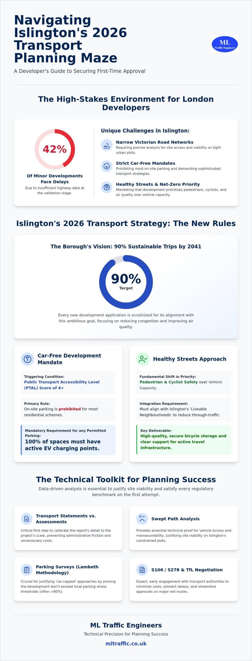
  • Planning Permission Traffic Issues: A Developer’s Guide to 2026 Approvals

    Planning Permission Traffic Issues: A Developer’s Guide to 2026 Approvals

    A Highways Authority objection shouldn’t be the end of your development project. Many developers view planning permission traffic issues as insurmountable hurdles; however, they’re actually technical puzzles that you can solve with precise data. It’s frustrating to face unexpected costs for off-site works, especially when local authorities are already holding over £915 million in unspent highway contributions as of 2026. You need a reliable way to move past these regulatory pressures and keep your project timeline on track.

    This guide provides a clear strategy to identify, mitigate, and resolve highway objections to secure your approvals. You’ll learn how to produce technical reports that satisfy the Local Planning Authority while reducing unnecessary mitigation expenses. We’ll examine the updated 2026 Transport Analysis Guidance and show you how specialized tools like Swept Path Analysis and Transport Statements provide the technical authority required to clear your path to planning permission. Outside of the planning sphere, other industries also rely on precision technology to manage complex vehicle data; for example, you can learn more about Carcode Mileage Blockers and their specialized applications.

    Key Takeaways

    • Identify common highway objections, such as inadequate visibility splays, before they lead to formal application delays.
    • Differentiate between Transport Statements and Assessments to ensure you submit the correct documentation for planning permission traffic issues.
    • Utilize Swept Path Analysis to verify that fire tenders and refuse vehicles can maneuver safely within your proposed development.
    • Deploy strategic mitigation tools like Travel Plans to address local congestion concerns and reduce a project’s car dependency.
    • Engage in early pre-application consultation to resolve technical hurdles and avoid the high costs of planning appeals.

    Common Highway and Traffic Issues in Planning Permission

    Securing project approval requires a proactive approach to planning permission traffic issues. Most refusals stem from four core technical failures: unsafe site access, excessive traffic volume, inadequate parking, and poor pedestrian connectivity. If your site entrance lacks the required visibility splays, it creates a safety hazard that planners cannot ignore. Similarly, if a development significantly increases congestion at a local junction, the impact may be deemed unacceptable. In urban centers, the 2026 London Plan now mandates car-free developments in areas with high public transport accessibility, making parking provision a critical compliance hurdle.

    To better understand how these objections manifest during the planning process, watch this helpful video:

    The Role of the Local Highway Authority (LHA)

    The LHA serves as a statutory consultee, providing expert technical advice to the planning officer. While they don’t issue the final decision, their recommendation for refusal is often a project-killer. Local authorities are currently holding approximately £915 million in unspent Section 106 funds for highways, yet they remain under pressure to ensure new developments don’t degrade the existing network. Early engagement with highways officers is the most effective way to prevent 2026 application delays. By addressing planning permission traffic issues during the pre-application stage, you can align your design with local standards and secure a positive recommendation from the start.

    Safety vs. Capacity: What Concerns Planners Most?

    The National Planning Policy Framework (NPPF) sets a high bar for capacity-based refusals, stating that development should only be prevented if the residual cumulative impacts on the road network are “severe.” Proving a “severe” impact is difficult and requires robust traffic modelling. In contrast, safety objections are immediate and harder to mitigate. A lack of adequate visibility or a failure to demonstrate safe vehicle tracking through Swept Path Analysis will trigger an automatic objection. These safety concerns are often documented within a wider Environmental Impact Assessment (EIA) for large-scale projects. While resident objections are often based on anecdotal fears of congestion, the LPA prioritizes technical data and safety standards over public opinion. Precision in your technical submission is the only way to neutralize these concerns.

    The Technical Reports Required to Resolve Traffic Objections

    Resolving planning permission traffic issues requires a data-led approach that prioritizes technical precision over general assumptions. Developers must provide technical reports that quantify the impact of their proposal and demonstrate safety compliance. For smaller projects, a Transport Statement is the standard requirement. This document outlines existing transport conditions and predicts how many trips the new site will generate. To ensure these predictions are robust, engineers use the TRICS database. This industry-standard tool compares your site to similar developments across the UK, providing a defensible baseline for trip generation that Highways Officers trust.

    Transport Statement vs. Transport Assessment

    The choice between a statement and an assessment depends on the scale of the development and the local context. Local authorities set specific thresholds for these reports based on official government guidance. While a statement covers basic site access and safety, a Transport Assessment is a comprehensive report required for larger, high-impact projects. It often includes complex junction modelling and a detailed analysis of the wider network capacity. If your project exceeds the local threshold, a simple statement will not satisfy the Highways Authority. In these cases, you must also submit Travel Plans to demonstrate how you will encourage sustainable transport use and reduce the overall carbon footprint of the site.

    The Importance of Accurate Traffic Data

    Technical authority relies entirely on the quality of the underlying data. Automatic Traffic Counts (ATC) provide 24-hour volume and speed data over several days, offering a more reliable picture than manual snapshots. When parking is a major concern, we conduct Parking Surveys using the Lambeth Methodology. This standardized approach measures parking stress within a 200-meter radius of the site, providing the empirical evidence needed to prove that a development won’t overwhelm local street capacity. Utilizing high-resolution 2026 traffic data ensures your application reflects current road conditions, effectively neutralizing objections based on outdated or anecdotal traffic figures.

    Precision in these reports reduces the risk of costly delays or requests for further information. If you are unsure which technical report your site requires, reviewing our comprehensive service list can help you identify the necessary documentation for a successful submission. Providing the right data early in the process establishes your project as a well-planned, safety-conscious development.

    Overcoming Specific Hurdles: Access, Visibility, and Maneuverability

    Physical constraints often create the most difficult planning permission traffic issues for developers. While a site might be perfectly located for residential use, it’s the geometry of the access point that determines its viability. You must prove that the site can accommodate the necessary vehicle movements without compromising the safety of the existing highway. This involves balancing high-density development goals with the rigid spatial requirements for parking and emergency vehicle access. Failing to address these spatial needs early often leads to costly redesigns or application refusals.

    Applying Swept Path Analysis (SPA)

    Planners require definitive proof that large vehicles can maneuver within your site. We use Swept Path Analysis to model these movements digitally. By utilizing AutoCAD and AutoTurn software, we simulate the exact path of fire tenders, refuse vehicles, and HGVs. This is particularly vital for tight urban developments or sites with narrow access roads where there’s zero margin for error. A successful SPA demonstration prevents the Highways Authority from objecting on the grounds of poor internal maneuverability. It allows you to maximize the developable area while ensuring the site remains fully functional for essential services.

    Visibility Splays and Highway Safety

    Safe site access depends on achieving correct visibility splays. These are the triangular areas that must be kept clear of obstructions so that drivers can see approaching traffic. We calculate the “X” distance (the distance back from the junction) and “Y” distance (the distance along the main road) based on local road speeds and the standards set out in Manual for Streets. With the updated “Manual for Streets 3” expected by the end of 2026, staying current with these evolving design standards is crucial for project success.

    Achieving these splays is often difficult on curved roads or near existing junctions. In these scenarios, we provide Expert Traffic Engineering Guidance to identify alternative mitigation options. This might include traffic calming measures or speed surveys to justify shorter splay lengths based on actual vehicle speeds rather than the speed limit. Resolving these hurdles early also prevents “ransom strip” issues where you might otherwise need third-party land to achieve the required visibility. Precision in these calculations ensures your site entrance meets safety benchmarks without requiring excessive land take.

    Strategic Mitigation: How to Turn a Refusal into an Approval

    Proactive mitigation transforms planning permission traffic issues from roadblocks into manageable project components. When a Local Planning Authority (LPA) identifies a potential “severe impact” on the network, you must propose tangible solutions to offset that pressure. This often involves a combination of behavioral changes through Travel Plans and physical infrastructure upgrades via statutory agreements. By offering these solutions upfront, you demonstrate a commitment to highway safety and network efficiency. This professional approach makes it significantly harder for planners to justify a refusal on traffic grounds.

    Developing an Effective Travel Plan

    A well-crafted Travel Plan is a powerful tool for reducing a site’s car dependency. In 2026, the shift toward “Active Travel” means planners prioritize developments that incentivize walking, cycling, and public transport use. We design these strategy documents to include practical measures like car-sharing schemes or cycle-to-work subsidies for future residents. Successfully implementing these measures can often lower the required parking ratio, which allows for higher site density. The LPA expects these plans to be living documents with clear monitoring and enforcement mechanisms to ensure long-term carbon reduction targets are met.

    Statutory Agreements: S278 and S38 Explained

    Physical road modifications require formal legal frameworks. A Section 278 (S278) agreement allows you to make permanent alterations to the existing public highway, such as creating a new junction or installing a pedestrian crossing. In contrast, a Section 38 (S38) agreement deals with the adoption of new roads built within the development itself. Managing the technical approval process for these works requires constant coordination with the Highways Authority to meet their strict design standards. You’ll need to account for technical audit fees, inspection costs, and the provision of a bond in your 2026 project budget. These agreements ensure that all works meet industry benchmarks for public and worker safety, and organizations like Acquired Awareness Traffic Management help set the standard for operational safety in traffic control.

    Financial contributions through Section 106 (S106) agreements also play a vital role. While local authorities currently hold £915 million in unspent highways funds, targeted contributions for public transport links can often resolve capacity concerns at local junctions. Planners don’t accept vague promises; they require binding commitments to infrastructure improvements. If your project faces a potential refusal due to highway capacity, contact our expert engineers to develop a robust mitigation strategy that secures your planning approval.

    Planning Permission Traffic Issues: A Developer’s Guide to 2026 Approvals

    Securing Permission with Expert Traffic Engineering

    A proactive technical strategy is the most effective way to resolve planning permission traffic issues before they escalate into costly legal battles. While some developers wait for a refusal to hire an expert witness, this approach is financially inefficient. An expensive planning appeal often takes months to resolve and offers no guarantee of success. In contrast, submitting a robust Transport Statement or Assessment at the start of the process establishes technical authority and builds trust with the Local Planning Authority. We focus on getting the application right the first time by providing defensible data that addresses the Highways Authority’s concerns directly.

    Effective project management requires a seamless relationship between architects, planners, and highways officers. We act as the vital technical partner in this triangle. Architects often prioritize site density and aesthetics, which can inadvertently lead to highway safety conflicts. We review these designs through a safety-conscious lens, ensuring that access points and internal layouts meet all legislative requirements. By seeking pre-application advice and involving traffic consultants early, you can identify potential hurdles while the site layout is still flexible. This collaborative approach reduces regulatory pressure and ensures your project remains viable from inception to completion.

    The ML Traffic Engineers Approach

    Founded in 2014, ML Traffic Engineers specializes in navigating the intricate landscape of UK planning policy. We provide tailored reporting that speaks the language of local highways officers, addressing specific borough concerns with precision. Our team understands that time is a critical factor in development; therefore, we maintain a constant readiness to deliver rapid data collection and technical analysis. Whether it’s a complex urban site or a rural residential scheme, our proven track record in securing approvals stems from an unwavering commitment to industry benchmarks and professional integrity. We don’t just provide reports; we provide the technical solutions required to move your project forward.

    Next Steps for Your Application

    The earliest stages of the design phase offer the greatest opportunity to mitigate risk. We recommend a professional feasibility review of your site layout to catch potential planning permission traffic issues before they’re submitted for formal consultation. Commissioning a Transport Assessment or Statement early allows our engineers to integrate safety and maneuverability requirements into your master plan. This prevents the need for expensive redesigns later in the process. Contact ML Traffic Engineers today to discuss your project requirements and secure a clear path to planning approval for your 2026 development.

    Streamline Your 2026 Planning Approvals

    Navigating the complexities of 2026 highway regulations requires more than just compliance; it demands a strategic, data-led approach. By addressing visibility splays and maneuverability through precise Swept Path Analysis and providing robust Transport Statements early, you eliminate the ambiguity that often leads to refusal. These proactive steps ensure that your project meets safety standards while maximizing developable space on even the most constrained urban sites—an engineering feat that reflects the same attention to detail found in the narrow gauge model kits from Narrow Minded Railworks.

    Successfully managing planning permission traffic issues is about translating technical requirements into a clear path for approval. We’ve been specialist consultants in UK transport planning since 2014, providing comprehensive support from initial pre-application advice to final S278 agreements. Our expertise ensures that your technical reports satisfy the Local Planning Authority without incurring unnecessary mitigation costs. Contact ML Traffic Engineers today for a bespoke quote on your Transport Statement or Assessment. Let us handle the regulatory pressures so you can focus on delivering your development. Your project’s success is within reach when backed by technical precision and expert engineering.

    Frequently Asked Questions

    What are the most common traffic issues that lead to planning refusal?

    Inadequate visibility splays and “severe” impacts on local junction capacity are the primary reasons for refusal. Planners also frequently cite a lack of safe pedestrian connectivity or insufficient parking provision that exceeds local standards. These planning permission traffic issues often stem from a failure to provide technical data that justifies the proposed development’s impact on the existing road network.

    Can I get planning permission if my site has poor visibility?

    You can secure planning permission with restricted visibility by implementing physical mitigation or justifying shorter splay lengths with empirical speed data. If a speed survey proves that actual vehicle speeds are lower than the posted limit, the required “Y” distance can often be reduced. Other solutions include relocating the site access point or installing traffic calming measures to ensure safe exit and entry for all users. While developers focus on the physical infrastructure, individual driver proficiency is also essential for safe roads; for those looking to schedule a driving exam in the Canadian province, you can learn more about the booking process.

    How much does a Transport Statement cost for a small development?

    The cost of a Transport Statement varies based on the site’s location, the complexity of the access point, and the specific requirements of the local authority. Every project has unique technical hurdles that influence the amount of data collection and engineering analysis required. We recommend requesting a bespoke quote to ensure the reporting matches the exact scale and risk profile of your development without paying for unnecessary modelling.

    What is the difference between a Transport Statement and a Transport Assessment?

    The primary difference lies in the scale of the development and the depth of the required network analysis. Transport Statements are for smaller projects with limited traffic impact, focusing mainly on site access and local safety. Transport Assessments are comprehensive reports for larger developments that require detailed junction modelling and a multi-modal evaluation of the wider transport network’s capacity and environmental impact.

    How does Swept Path Analysis help with fire brigade access requirements?

    Swept Path Analysis provides digital proof that a fire tender can enter, turn, and exit your site without striking curbs or parked cars. Building Regulations Part B requires specific access for emergency vehicles, and planners use these simulations to verify compliance. By modelling the exact dimensions of a standard fire appliance, we ensure your site layout is safe and functional for emergency services from the earliest design stage. While ensuring road access for these vehicles is vital, you can also explore Stage 1 Performance Remap to optimize the engine performance and fuel efficiency of your own vehicle fleet.

    What happens if the Highways Authority objects to my planning application?

    A Highways Authority objection is a technical recommendation for refusal, but it’s not a final decision by the planning officer. You should immediately review the technical grounds for the objection and provide updated data or mitigation strategies to address their concerns. Engaging in a professional technical dialogue often leads to a compromise or a revised design that satisfies safety and capacity requirements while avoiding an appeal.

    Do I need a Travel Plan for a residential development of 10 units?

    Requirements for Travel Plans vary between local authorities, but they’re increasingly common for developments of 10 units or more in urban areas. In 2026, many planners demand these documents to prove how you’ll reduce car dependency and support active travel. Even for smaller sites, a proactive Travel Plan can help resolve planning permission traffic issues by justifying a lower parking ratio and demonstrating environmental commitment.

    What is a Section 278 agreement and why do I need one?

    A Section 278 agreement is a legal contract between a developer and the Highway Authority for permanent alterations to the public road. You need one whenever your project requires a new junction, a modified pavement, or improved street lighting on land owned by the council. This agreement ensures that the works meet strict safety standards and are completed at the developer’s expense under the supervision of the local authority.

    Michael Lee

    Article by

    Michael Lee

    Transport planner with over 35 years' experience.

    Disclaimer

    The content on mltraffic.co.uk, including all technical articles, guides, and resources, is provided for general informational and educational purposes only. It is not intended to constitute professional advice in traffic engineering, transportation planning, development approvals, or any other technical or legal field.
    While ML Traffic Engineers makes every reasonable effort to ensure the accuracy, completeness, and timeliness of the information published, we do not provide any warranties or representations (express or implied) regarding its reliability, suitability, or availability for any particular purpose. Any reliance you place on the content is strictly at your own risk.
    In no event shall ML Traffic Engineers, its directors, employees, authors, or affiliates be liable for any direct, indirect, incidental, special, consequential, or punitive damages (including, without limitation, loss of profits, data, or business opportunities) arising out of or in connection with the use of, or inability to use, any information provided on this website.
    The articles and guides on this site are not a substitute for engaging a qualified, professional traffic engineer to assess your specific project requirements. For tailored advice, compliance assessments, or traffic engineering services, please contact a competent professional.
    This disclaimer may be updated from time to time without notice. By accessing or using this website, you agree to be bound by the most current version of this disclaimer.