Human error contributes to 88% of road collisions, a statistic that has pushed Local Highway Authorities in 2026 to demand unprecedented levels of technical precision. For developers, this means a standard site entrance is no longer enough to clear the planning hurdle. You likely recognize the pressure of managing tight project timelines only to face a refusal because a visibility splay is insufficient or a refuse vehicle cannot turn safely. It’s a common bottleneck that delays construction and drains resources.
This guide ensures you master every technical requirement for a vehicle access design for planning application that secures immediate approval. We’ll provide the clarity needed to navigate complex local highway guides and the updated Design Manual for Roads and Bridges. You’ll learn how to leverage industry-standard software for Swept Path Analysis and align your site with the 2026 Automated Vehicles Act. By following these safety standards, you can transform a potential regulatory headache into a planning-ready design that satisfies every LHA requirement from the first submission.
Key Takeaways
- Understand why Local Highway Authorities prioritize access scrutiny and how to transition from generic templates to site-specific, justified design solutions.
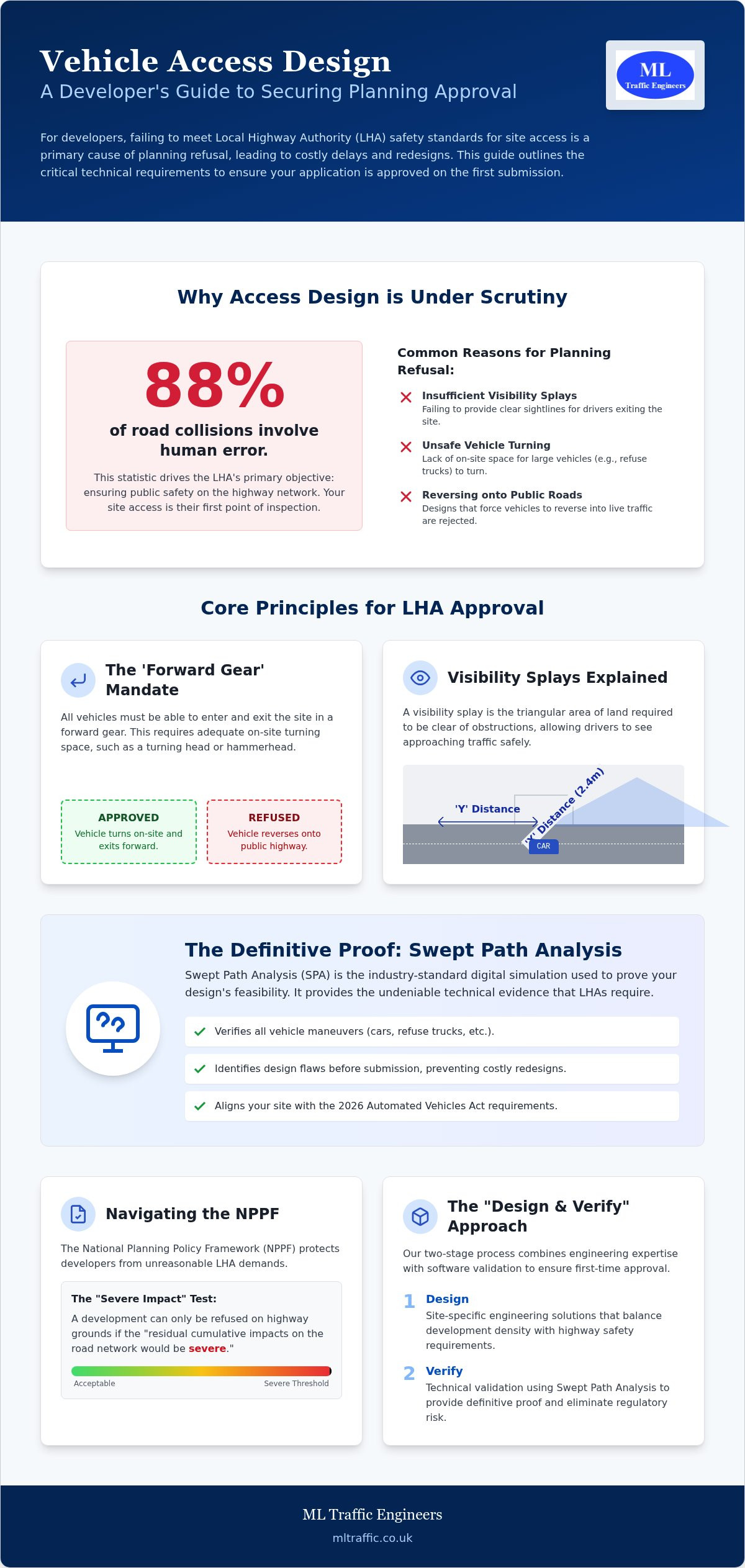
- Master the “Forward Gear” requirement and the precise calculation of visibility splays to eliminate the risk of refusal on safety grounds.
- Utilize Swept Path Analysis as the definitive technical proof for your vehicle access design for planning application, ensuring all maneuvers are verified through digital simulation.
- Identify the distinct requirements for Section 278 and Section 38 agreements to streamline your transition from planning approval to highway adoption.
- Learn how a “Design and Verify” approach combines engineering expertise with industry-standard software to reduce regulatory pressure and project delays.
The Strategic Importance of Vehicle Access Design in Planning
Highway Officers scrutinize vehicle access design for planning application submissions before almost any other technical detail. Their primary objective is public safety. An access point that fails to meet visibility or turning standards creates a permanent liability on the public highway. In 2026, the expectation has shifted from applying generic design templates to providing site-specific, justified access solutions. This transition requires developers to use technical data and established Access Management Principles to prove that their proposed junction is both safe and efficient.
Failing to prioritize this design early in the project lifecycle introduces significant financial risk. If a layout is finalized before the access is verified, a single objection from the Local Highway Authority (LHA) can force a complete site redesign. This results in wasted architectural fees and missed planning deadlines. Integrating your access strategy directly into your Transport Statement ensures that the technical justification is present from day one, reducing the likelihood of costly post-submission revisions.
Highway Safety vs. Development Density
A common conflict exists between maximizing site density and meeting highway safety requirements. Architects often seek to place units as close to the site boundary as possible to increase yield. However, this often compromises the visibility splays required by the LHA. We find that the most successful projects balance these needs early. Over-engineering a junction can be just as problematic as under-designing it; excessive road widths or unnecessarily large radii waste valuable land and can encourage higher vehicle speeds, which undermines residential safety.
The Role of the National Planning Policy Framework (NPPF)
The NPPF provides the legal backbone for access negotiations in England. It protects developers from arbitrary or excessive demands by the LHA by setting a high bar for refusal. In 2026, practitioners must focus on the “severe residual cumulative impacts” threshold. If a developer can prove their access design doesn’t cross this line, the LHA has limited grounds for objection. The NPPF states that development should only be prevented or refused on highways grounds if there would be an unacceptable impact on highway safety, or the residual cumulative impacts on the road network would be severe.
Core Design Principles: Forward Gear and Visibility Splays
Precision in a vehicle access design for planning application centers on two critical factors: how a vehicle enters and leaves the site, and what the driver can see from the junction. Local Highway Authorities (LHAs) almost universally mandate that vehicles enter and exit in a forward gear. Reversing onto a classified road, such as an A, B, or C class carriageway, is a primary reason for planning refusal. In 2026, planning inspectors continue to uphold this safety standard during appeals, viewing reversing maneuvers as an unacceptable risk to road users.
The complexity of your access design is dictated by the road hierarchy and the potential intensification of use. If a development increases the volume or changes the type of traffic using an existing entrance, the LHA will re-evaluate the access against current safety benchmarks. This often happens in residential conversions where a domestic driveway is expected to serve multiple dwellings. To avoid delays, developers must prove that the existing geometry can handle the increased load without compromising the flow of the wider network.
The Ingress and Egress Mandate
Vehicles must have sufficient space to turn within the site boundary so they can always exit facing forward. On constrained urban plots, providing this space requires careful engineering of turning heads or hammerheads. While residential designs focus on cars and delivery vans, commercial developments must accommodate larger vehicles. If your site layout is particularly tight, performing a Swept Path Analysis during the initial design phase can identify whether your turning provision is technically feasible before you submit your application.
Visibility Splays and Manual for Streets (MfS)
Visibility is defined by X and Y distances. The X-distance is the driver’s set-back from the edge of the road, typically 2.4 meters. The Y-distance is the sightline length along the carriageway, which we calculate based on 85th percentile speed surveys rather than just the posted speed limit. In urban environments, we apply Manual for Streets (MfS) standards, which prioritize place-making and often allow for shorter splays. Conversely, rural or high-speed routes require the more stringent Design Manual for Roads and Bridges (DMRB) criteria.
A common hurdle involves visibility splays crossing third-party land. If you do not control the land within the splay, the LHA will likely object because you cannot guarantee the area remains free of obstructions. You must also ensure that street furniture, signage, and landscaping are positioned outside these sightlines. Even a small planter or a misplaced lamp column can result in a non-compliant vehicle access design for planning application, leading to a swift rejection from the highway officer.
Swept Path Analysis: The Technical Proof of Feasibility
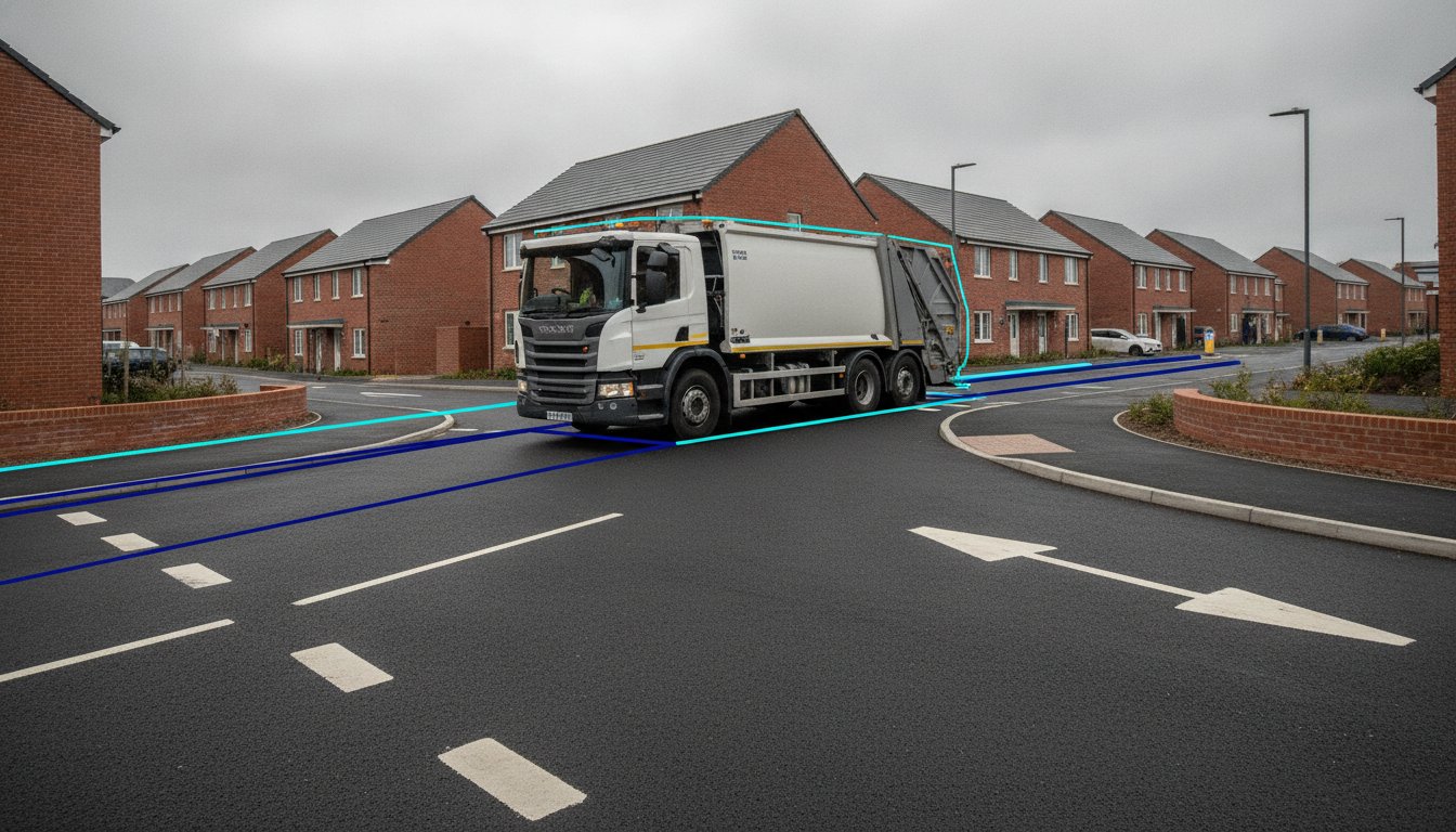
Highway Officers require technical proof that your proposed layout works in reality. Swept Path Analysis (SPA) provides this through digital vehicle simulation. It replaces static 2D drafting with a dynamic model of vehicle movement. This technology identifies “pinch points” where a vehicle’s body might overhang a footway or strike a boundary. For a vehicle access design for planning application, SPA is often the difference between a quick approval and a protracted dispute over feasibility. It serves as the definitive currency for highway negotiations in 2026.
The simulation process follows a logical sequence to ensure accuracy. We start by importing your site topography and proposed layout into industry-standard software like AutoTURN. We then select the appropriate design vehicle and plot the intended maneuver path for both ingress and egress. The software generates a swept path “envelope” that shows the space occupied by the vehicle. Finally, we assess the clearances against boundary walls, lamp columns, and street furniture to verify the design’s safety.
Choosing the Right Design Vehicle
A successful simulation shows more than just wheel tracks. It displays the full vehicle envelope, which includes body swing and mirror clearance. We typically include a 0.5m clearance margin to satisfy safety-conscious highway engineers. This data allows us to justify narrower road widths in sustainable developments. It proves that safe vehicle access design for planning application is possible without over-engineering the infrastructure. Precision here reduces the land take for roads, which helps you maximize the usable space for units or green infrastructure.
Navigating Highway Authority Standards and Agreements
Securing planning for a vehicle access design for planning application requires more than just a drawing. It involves navigating the legal agreements that govern how private land connects to the public highway. In England, developers primarily deal with Section 278 and Section 38 agreements. While a Section 38 agreement focuses on the adoption of entirely new roads within a development, a Section 278 agreement is necessary for any works that alter the existing highway, such as creating a new bellmouth or widening a crossover.
A robust submission package should include a checklist of technical documents to ensure the Highway Officer has everything needed for a formal recommendation. We recommend including:
- Scaled site access plans showing precise geometry and visibility splays.
- Swept Path Analysis results for critical vehicles like fire tenders or refuse trucks.
- A Transport Assessment or Statement to justify the access location.
- Speed survey data if you’re deviating from standard visibility requirements based on actual road speeds.
- Drainage and lighting strategies if the access significantly changes the highway footprint.
While demonstrating access for fire tenders is a planning necessity, ensuring the structural safety of your buildings through professional fire stopping is equally critical; you can learn more about National Fire Ltd for specialist passive fire protection services.
Seeking pre-application advice from the Local Highway Authority (LHA) is a strategic move. It allows you to identify potential objections regarding site entrance locations before you commit to a full architectural layout. LHAs often have specific preferences for junction types that aren’t always obvious from national guidance.
Section 278 (S278) Agreements Explained
The S278 agreement is the legal mechanism under the Highways Act 1980 that allows developers to make permanent changes to the public road. Although formal technical approval usually occurs after planning permission is granted, you must consider the S278 requirements during the initial design. If your proposed vehicle access design for planning application doesn’t meet the LHA’s specific technical standards for construction and drainage, you may face expensive redesigns during the post-planning technical audit phase.
Local Highway Design Guides vs. National Standards
Every council in England maintains its own “standard details” for access points. While the Manual for Streets provides national guidance, a Borough’s design manual might specify different radii for corners or specific materials for crossovers. We often find that local standards are more rigid than national research. In cases where local requirements make a site unviable, we use evidence-based research from national documents to challenge those standards and secure a bespoke approval.
If you need a technical partner to manage these regulatory hurdles, you can book a Transport Assessment or Swept Path Analysis to ensure your design meets both local and national benchmarks.
Expert Support for Your Access Design with ML Traffic Engineers
Securing a vehicle access design for planning application that satisfies both your vision and the Highway Authority’s safety requirements requires a technical bridge. ML Traffic Engineers provides this bridge by combining deep engineering intuition with advanced simulation technology. Our ‘Design and Verify’ approach ensures that every site entrance is not just a drawing, but a functional, safe, and adoptable piece of infrastructure. By identifying potential highway objections early, we reduce the regulatory pressure on your team and prevent the delays that often derail high-stakes developments.
We understand that access design doesn’t exist in a vacuum. It is a fundamental component of your wider submission. We ensure your access strategy integrates seamlessly into your Transport Statements and Travel Plans. This holistic approach provides a consistent narrative to the planning officer, demonstrating that every aspect of vehicle movement has been meticulously planned and verified. Getting a professional review of your vehicle access design for planning application before you submit to the council is the most effective way to protect your project from technical refusals.
Why Developers Trust ML Traffic Engineers
Since our founding in 2014, we’ve focused exclusively on providing technical reporting and analysis for projects across England. We don’t just provide data; we provide solutions. Our team has direct experience negotiating with Highway Authorities, which allows us to anticipate their concerns and address them within our reports. We pride ourselves on precision and adherence to standards, delivering clear, actionable technical documents that bridge the gap between architectural aesthetics and highway safety.
Next Steps for Your Planning Application
The most efficient way to move forward is to request a site-specific access feasibility study. We work directly with your architects to refine site layouts, ensuring that visibility splays and turning heads are optimized without sacrificing development density. This collaborative process ensures your layout is planning-ready from the first draft. Contact our team today for a Transport Planning Consultation to discuss your site’s specific access requirements and secure the technical proof needed for approval.
Securing Your Site’s Future with Compliant Access Design
A successful vehicle access design for planning application requires a precise balance of safety, technical simulation, and regulatory knowledge. Mastering the forward-gear rule and visibility splays is critical to avoiding immediate refusal from the Local Highway Authority. By utilizing advanced Swept Path Analysis, you provide the definitive proof Highway Officers need to approve your site layout. Navigating the complexities of Section 278 and Section 38 agreements early in the process ensures that your project remains viable from inception through to adoption.
Precision is a functional necessity in this high-stakes environment. Since 2014, ML Traffic Engineers has provided professional Transport Planning Reports that act as the technical bridge between architectural vision and highway safety. Our advanced Swept Path Analysis capabilities and expertise in S278 and S38 requirements reduce the logistical pressures on your development team. Secure your planning approval with expert vehicle access design from ML Traffic Engineers. We’re ready to help you transform complex highway standards into a clear path for project success.
Frequently Asked Questions
Do I need planning permission for a new vehicle access on a classified road?
Yes, you must obtain planning permission for any new vehicle access connecting to a classified road, which includes A, B, and C class carriageways. While creating an entrance on an unclassified residential street might sometimes fall under permitted development, classified routes are strictly regulated due to higher traffic volumes and speeds. Your vehicle access design for planning application must include technical evidence that the new junction doesn’t compromise the safety or flow of the existing highway network.
What is the minimum width for a residential vehicle access in the UK?
For a single residential dwelling, the minimum width is typically 3 meters. If the access serves multiple properties, Local Highway Authorities often require a width of 4.5 meters to 5.5 meters to allow two vehicles to pass simultaneously. These dimensions ensure that vehicles don’t have to wait on the public highway, which reduces the risk of collisions. Always check your specific council’s design guide because standard details vary between different boroughs in England.
Why is ‘ingress and egress in forward gear’ so important for planning?
Safety is the primary reason why Local Highway Authorities mandate that vehicles enter and exit a site in a forward gear. Reversing onto a classified road is a high-risk maneuver that significantly increases the likelihood of accidents with passing traffic or pedestrians. If your site layout doesn’t provide enough space for a vehicle to turn internally, the highway officer will likely recommend refusal. This requirement is a non-negotiable foundation of modern highway safety standards.
How much visibility do I need for a 30mph road access?
On a standard 30mph urban road, the Manual for Streets typically requires a visibility splay of 2.4 meters for the X-distance and 43 meters for the Y-distance. However, if a speed survey reveals that the 85th percentile speed is higher than 30mph, the required Y-distance will increase accordingly. It’s vital to measure these sightlines from a height of 1.05 meters to ensure drivers have a clear view of approaching vehicles, cyclists, and other road users.
Can a planning application be refused solely on vehicle access grounds?
Yes, a planning application can be refused solely on highway safety grounds if the proposed vehicle access is deemed unsafe. If the design fails to provide adequate visibility splays or lacks sufficient internal turning space, the Local Highway Authority will issue a formal objection. Under the National Planning Policy Framework, development can be prevented if the impact on highway safety is unacceptable or the residual cumulative impacts on the road network are severe.
What vehicle should I use for my Swept Path Analysis simulation?
The choice of vehicle depends entirely on the nature of your development. For most residential projects in England, the 11.4 meter refuse collection vehicle is the “gold standard” required by highway officers. Commercial or industrial sites usually require simulations using a 16.5 meter articulated heavy goods vehicle (HGV). Using the correct design vehicle for your vehicle access design for planning application ensures that the most restrictive maneuvers are technically verified before submission.
What is the difference between a dropped kerb and a full vehicle access?
A dropped kerb refers specifically to the physical alteration of the pavement to allow a vehicle to cross the footway. In contrast, a full vehicle access encompasses the legal permission and technical design of the junction where your private land meets the public highway. While a dropped kerb is a construction detail, the vehicle access includes visibility splays, drainage, and turning requirements that must be approved by the planning and highway authorities before any work begins.
How long does it take to get highway technical approval for an access design?
The timeline for highway technical approval varies depending on the complexity of the project. A standard planning response from the Local Highway Authority usually takes between 6 and 12 weeks. However, if your project requires a formal Section 278 agreement for works on the public highway, the technical audit and legal drafting process can take several months. Early engagement through pre-application advice is the best way to accelerate these regulatory and technical timelines.

Disclaimer
The content on mltraffic.co.uk, including all technical articles, guides, and resources, is provided for general informational and educational purposes only. It is not intended to constitute professional advice in traffic engineering, transportation planning, development approvals, or any other technical or legal field.
While ML Traffic Engineers makes every reasonable effort to ensure the accuracy, completeness, and timeliness of the information published, we do not provide any warranties or representations (express or implied) regarding its reliability, suitability, or availability for any particular purpose. Any reliance you place on the content is strictly at your own risk.
In no event shall ML Traffic Engineers, its directors, employees, authors, or affiliates be liable for any direct, indirect, incidental, special, consequential, or punitive damages (including, without limitation, loss of profits, data, or business opportunities) arising out of or in connection with the use of, or inability to use, any information provided on this website.
The articles and guides on this site are not a substitute for engaging a qualified, professional traffic engineer to assess your specific project requirements. For tailored advice, compliance assessments, or traffic engineering services, please contact a competent professional.
This disclaimer may be updated from time to time without notice. By accessing or using this website, you agree to be bound by the most current version of this disclaimer.