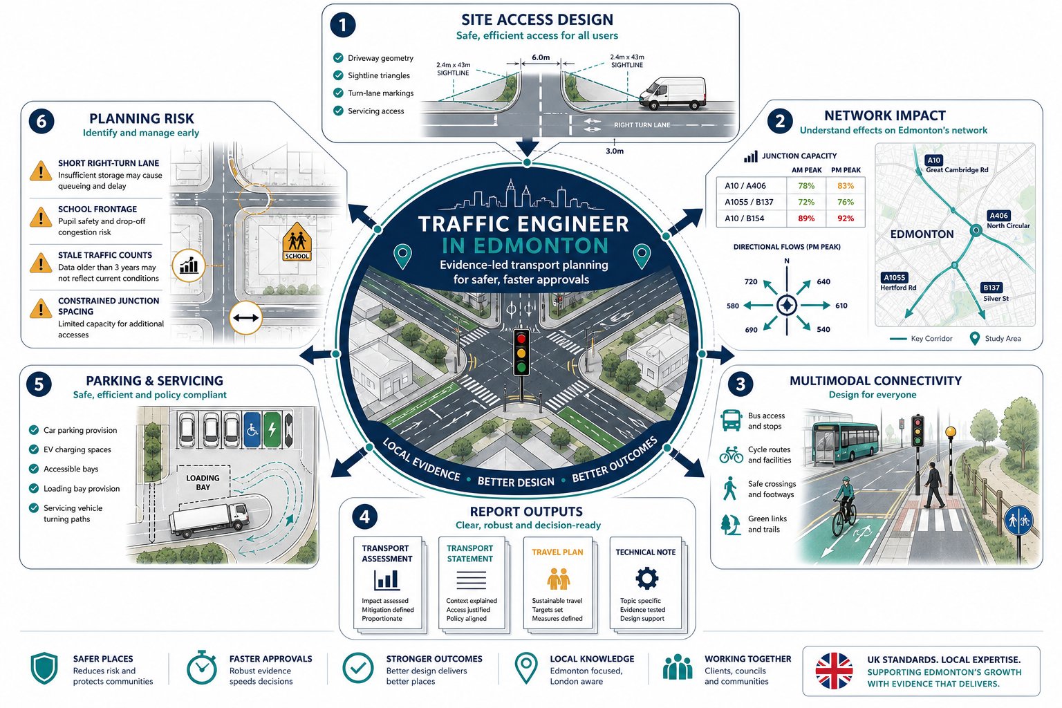
Planning risk often hides in ordinary places: a right-turn lane that’s too short, a servicing route that clashes with school traffic, a junction model based on stale counts, a site access drawn before anyone has tested sightlines. In Edmonton, those details can decide whether an application moves smoothly or gets bogged down in highways queries.
That’s where a traffic engineer in Edmonton becomes central to the development team. We’re not simply producing a report to sit at the back of a planning submission. We’re translating a scheme into transport terms the City, reviewers and stakeholders can interrogate with confidence: how many trips it will generate, where they’ll go, whether nearby junctions can cope, how people will walk, cycle, take transit, park, load and turn.
For architects, planners, lawyers, surveyors, builders, developers and local authorities, the value is practical. Early traffic input can shape a layout before it hardens into a problem. It can identify when a concise technical note is enough and when a full Transport Assessment is unavoidable. And it can narrow the room for disagreement by grounding the discussion in evidence, modelling and standards.
In this guide, we set out what a traffic engineer in Edmonton typically does for planning applications, when formal transport reporting is likely to be required, how local context affects advice, and which issues most often delay approvals in 2026.
Key Takeaways
- A traffic engineer in Edmonton ensures development proposals function safely and efficiently by assessing access, parking, circulation, and impact on nearby roads and junctions.
- Transport Assessments or Statements are required based on the size, traffic impact, and local sensitivity of a development, with scoping tailored to Edmonton’s specific site context.
- Local factors like road hierarchy, nearby land uses, and transit infrastructure heavily influence traffic advice, making local knowledge essential for robust planning.
- Early involvement of a traffic engineer can prevent costly redesigns by addressing access, safety, and operational issues before layouts are finalised.
- Comprehensive traffic evidence supports architects, planners, and developers by reducing uncertainties and facilitating informed decisions, expediting approvals.
- Consistent, current data and coordinated reporting across access, parking, and travel plans are critical to avoid delays and queries in Edmonton’s planning process.
What A Traffic Engineer In Edmonton Does For Planning Applications
A traffic engineer in Edmonton supports planning applications by testing whether a development will function safely and efficiently within its surrounding network. That sounds simple. In practice, it covers a fairly wide brief.
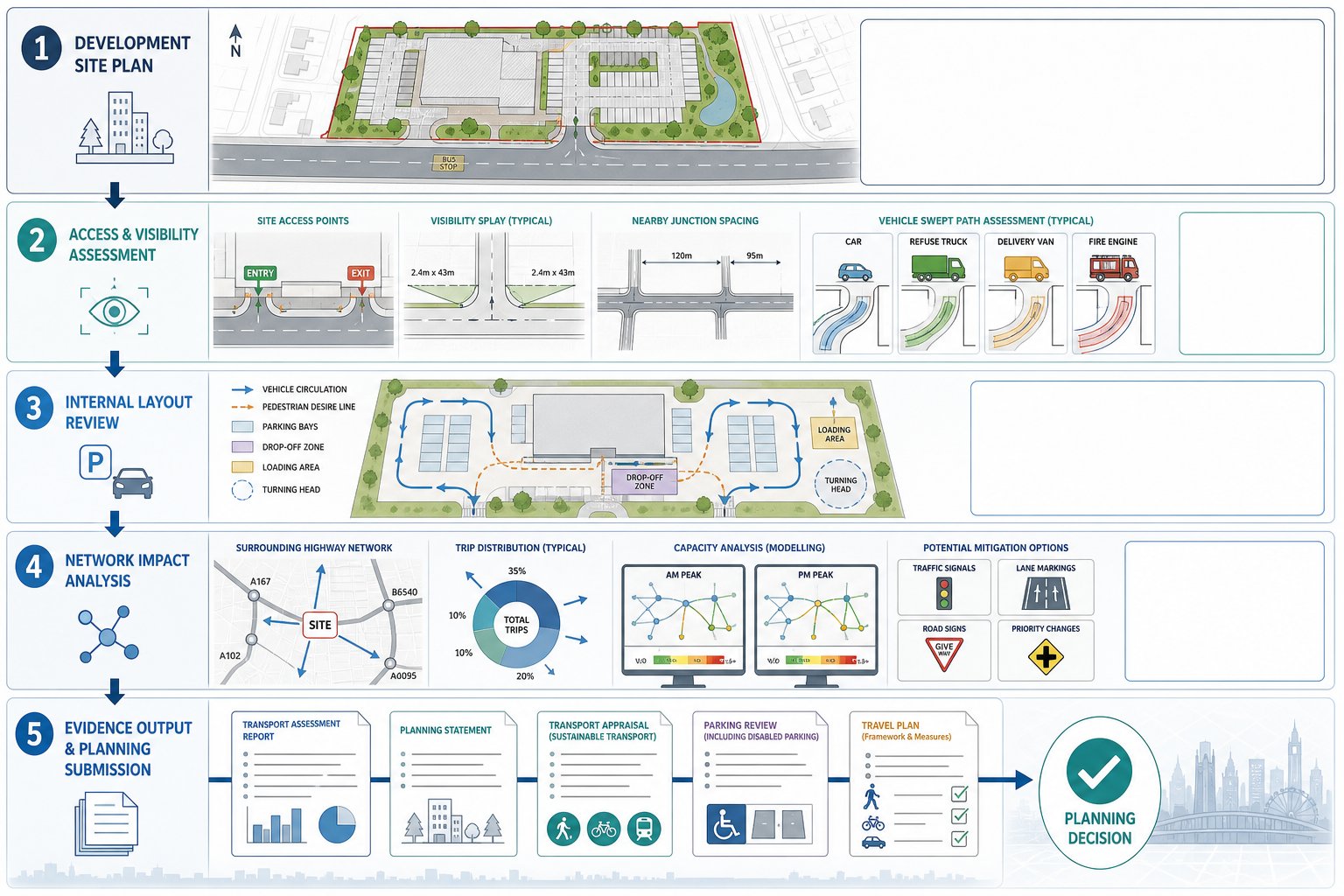
We usually begin with access: where vehicles enter and leave, whether that access can achieve suitable visibility, how close it sits to nearby junctions, and whether its geometry works for cars, refuse vehicles, delivery vans and emergency appliances. From there, we review internal circulation, parking layout, drop-off areas, loading, turning heads and pedestrian desire lines. If the site is mixed-use or phased, those questions get more layered very quickly.
We also assess the effect of the proposal on adjoining roads and junctions. That may involve trip generation, distribution and assignment, then capacity modelling through tools such as Synchro, SIDRA or microsimulation platforms where the context justifies it. If signals, lane markings, signing or priority arrangements need to change, we can set out what mitigation is likely to be reasonable and technically acceptable.
For planning teams, the end product is usually a proportionate piece of evidence: a Transport Assessment, Transport Statement, technical note, access appraisal, parking review or Travel Plan. The point isn’t paperwork for its own sake. It’s to give decision-makers a clear basis for judging whether the development works. Our role often overlaps with broader Traffic Engineering and Transportation advice, especially where layout and movement strategy need to be coordinated early rather than fixed later under pressure.
When A Transport Assessment Or Transport Statement Is Likely To Be Needed
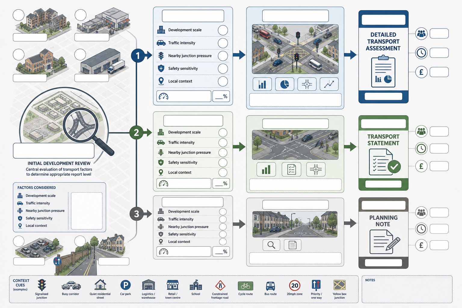
The level of reporting depends on scale, traffic effect and sensitivity of location. A full Transport Assessment is generally expected where a scheme is larger, traffic-intensive or likely to create noticeable impacts on capacity, safety or mode share. Think substantial residential development, retail parks, employment sites, education uses, logistics premises or schemes near constrained junctions. If nearby intersections already operate close to capacity, even a moderate development can tip the balance and trigger detailed analysis.
A Transport Statement is usually more proportionate for smaller proposals with limited impact. It still needs to be robust, but it tends to use simpler forecasting, standard trip rates and focused commentary on access, parking and local movement conditions rather than a full modelling package. Then there’s the technical note: sometimes a single planning issue needs answering, such as whether a revised access spacing is acceptable or whether a parking change alters the original conclusions.
The real judgement call is not just size: it’s context. A 20-unit scheme on a quiet street isn’t the same as a 20-unit scheme beside a school, a busy signalised corridor or a constrained frontage road. That’s why scoping matters. At the outset, we usually advise clients on whether the likely requirement is a TA, TS or shorter note, and what survey or modelling effort is sensible. For development teams wanting a broader overview of thresholds and strategy, our work as Traffic Engineering Consultants: What tends to follow the same principle: proportionate evidence, but no guesswork.
How Edmonton Site Context Shapes Traffic And Access Advice
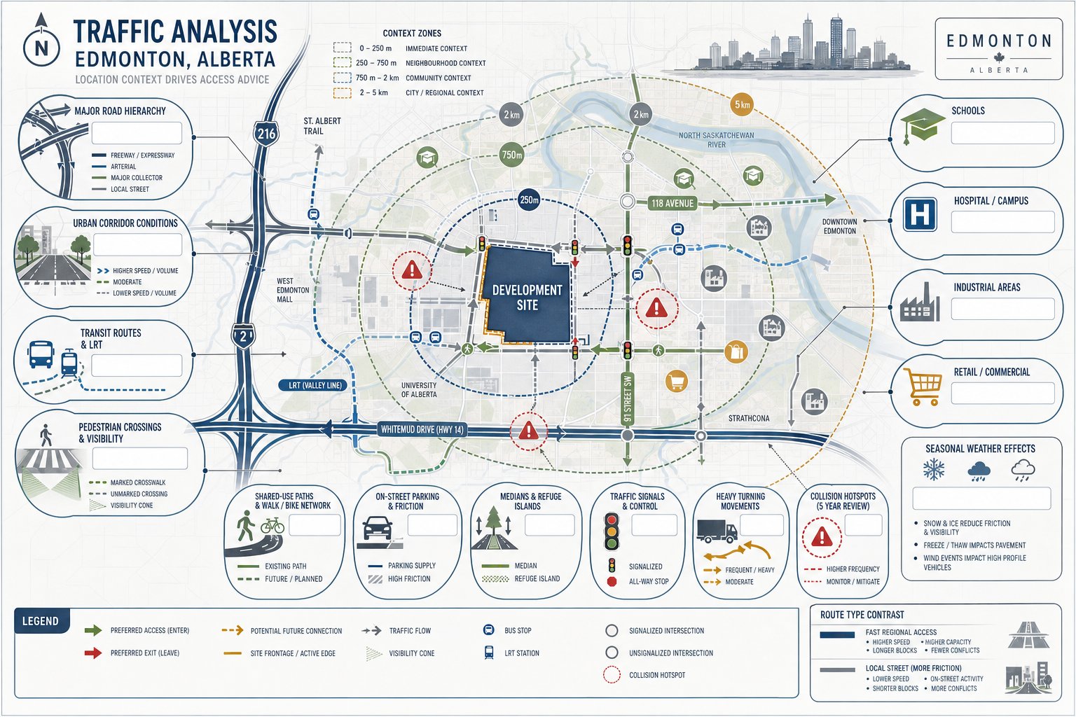
A report prepared for Edmonton can’t be generic. Access and transport advice is shaped by where the site sits in the city’s road and transit structure, what the surrounding land uses are doing, and which authority standards apply.
A parcel with quick access to Anthony Henday Drive may raise different questions from an infill site fronting a busier urban corridor with frequent driveways, schools and pedestrian crossings. Some sites are dominated by regional traffic and heavy turning flows: others by local access friction, on-street parking pressure, or transit and active travel expectations. If the site is near a hospital, campus, industrial district or major retail node, peak patterns can also behave differently from standard commuter assumptions.
We hence look beyond the red line. Street hierarchy, nearby control devices, established rat-runs, collision history, seasonal conditions and frontage constraints all matter. Even subtle features can change the advice: a crest affecting visibility, a median restricting movements, a bus stop too close to an access, or a shared-use path that introduces more crossing demand than the initial layout assumed.
Good transport advice is local before it is technical. The modelling may be rigorous, but the judgement behind it comes from understanding how Edmonton actually operates on the ground.
Key Highways And Junction Considerations
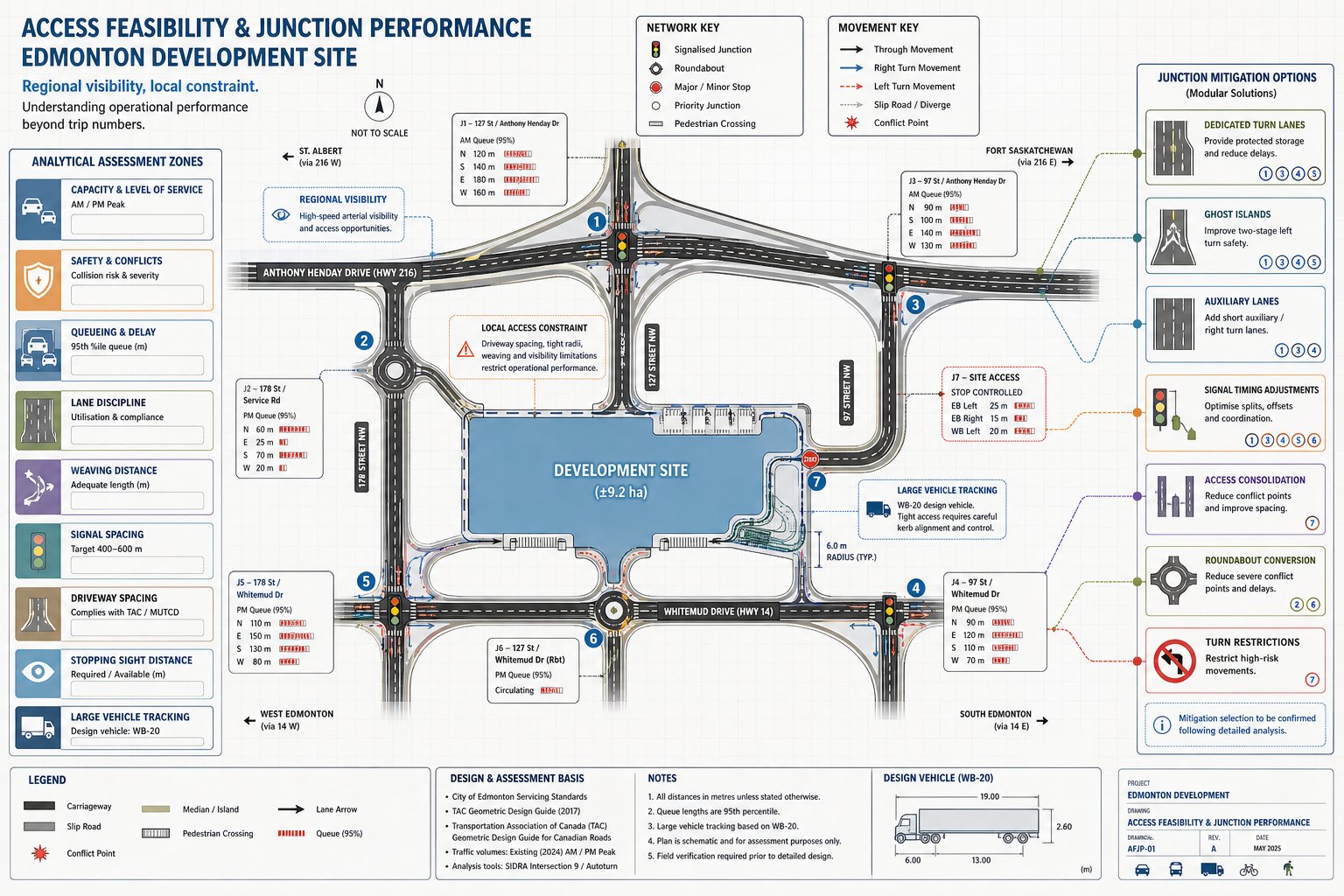
The first question around a new access or traffic impact is usually straightforward: can the surrounding highway network cope? But “cope” has a few dimensions. Capacity is one. Safety is another. Operational quality, queueing, lane discipline and resilience matter too.
In Edmonton, major corridors such as Anthony Henday Drive, Whitemud Drive, Yellowhead Trail and Calgary Trail / Gateway Boulevard can heavily influence routing and access feasibility. A site may have excellent regional visibility yet poor local access options because of median control, limited weaving distance or nearby signals. Equally, a seemingly modest local junction can become the critical constraint if turning movements stack back into a corridor.
We review priority and signalised junction performance using established capacity methods, then test whether mitigation is needed: ghost islands, dedicated turn lanes, auxiliary lanes, revised signal timings, access consolidation, roundabout options or restrictions on certain movements. Geometry, stopping sight distance, driveway spacing and vehicle tracking all sit alongside the modelling. On some schemes, the main issue isn’t the number of trips at all: it’s whether the largest vehicle can turn without overrunning pedestrian space or opposing lanes.
This is where early Highway And Traffic input can save a redesign. Once an architect has fixed building lines, service yards and frontage treatment, the room to resolve a weak access point becomes much smaller.
Public Transport, Walking And Cycling Connections
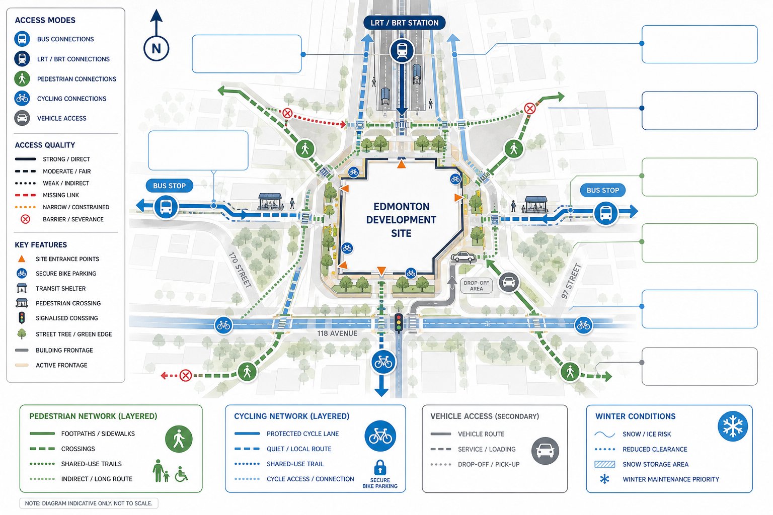
Planning authorities increasingly expect a multi-modal case, not a vehicle-only one. So when we assess a site in Edmonton, we look at bus routes, stop locations, LRT or BRT access, crossing opportunities, sidewalks, trails and cycling infrastructure with the same seriousness as vehicular access.
A development may be technically reachable by transit, but if the walking route to the nearest stop includes poor crossings, narrow footways, missing links or winter maintenance concerns, the practical accessibility story is weaker. The same applies to cycling. A painted route on a map isn’t the full picture if the actual connection involves awkward driveway crossings, indirect access or little secure cycle parking on site.
Our advice often feeds directly into frontage design and internal layout: where to place pedestrian entrances, whether a connection to a shared-use trail should be formalised, how drop-off activity might affect walking routes, or whether a cycle link can reduce short car trips. These points also matter in mode share discussions and Travel Plans. For many urban schemes, a credible active travel and transit strategy helps explain why trip rates may differ from a conventional suburban benchmark.
That broader approach sits comfortably with Commercial Traffic Engineering work too, because modern planning decisions rarely rest on junction modelling alone.
Common Reports Prepared For Edmonton Developments
The report type should match the planning question. In Edmonton, we commonly prepare Transport Assessments, Transport Statements, traffic impact studies, turning movement analyses, parking reviews, access appraisals, construction traffic plans and short technical notes responding to specific comments.
For a straightforward change of use, a concise note may be enough. For a medium-sized residential or commercial proposal, a Transport Statement might cover trip generation, local access effects, parking and sustainable travel context. For larger or more sensitive sites, a full Transport Assessment usually adds surveyed baseline conditions, future year scenarios, distribution assumptions, junction modelling, mitigation testing and implementation recommendations.
Parking work can be a report in its own right where demand, shared use, EV provision or spillover concerns are central. On constrained urban sites, an access appraisal may compare several options and set out why one arrangement is safest and most operationally robust. Construction traffic plans also matter more than many teams expect, especially where schools, narrow streets or significant demolition phases are involved.
The strongest submissions are usually the ones where these reports are coordinated rather than commissioned in isolation. A parking review should not contradict the Travel Plan. An access note should align with the architect’s swept path drawings. And the TA should reflect the scheme actually being submitted, not an older iteration lingering in someone’s inbox.
Transport Assessments, Statements And Technical Notes
A Transport Assessment is the most comprehensive planning document in this family. It typically covers existing network conditions, surveyed traffic flows, sustainable transport context, trip generation, distribution, assignment, future baseline scenarios, junction modelling, safety review, parking and servicing, then mitigation and conclusions. Where phasing is relevant, it should explain what happens at each stage rather than hiding everything in an end-state forecast.
A Transport Statement is lighter but still structured. We normally use it for proposals where impacts are limited and the key task is to demonstrate that access, parking and local movement effects are acceptable without extensive modelling. Standard trip rates, reasoned judgement and a concise review of site conditions can be enough if the planning risk is genuinely low.
Technical notes are narrower. They answer one question well: perhaps whether a revised site plan changes access performance, whether one junction needs an updated model, or whether additional counts alter the earlier conclusion. They’re especially useful after officer feedback, because they let the team respond precisely instead of reopening the whole submission.
Across all three, proportionality is the discipline. We draw on the same principles found in Traffic Engineering: Your Complete approach: enough evidence to answer the planning issue properly, but not pages of theatre pretending to be certainty.
Travel Plans, Parking Reviews And Access Appraisals
Travel Plans are often underestimated because they sound aspirational. Done properly, they are practical management documents. They set out measures that can encourage transit use, walking, cycling, car-sharing and smarter trip timing, then link those measures to monitoring and review. For some developments, that might include welcome packs, cycle facilities, subsidised transit information, car club spaces, end-of-trip facilities or employer travel coordination.
Parking reviews are more data-led than many people assume. We test supply against by-law standards, operational needs, accessibility requirements, EV charging expectations and likely demand profiles by time of day. Shared-use parking can be efficient, but only if the peaks genuinely differ. Otherwise, the “shared” spaces are just double-counted optimism. Our parking strategy traffic work often comes into play where a development team needs to justify restraint without creating spillover problems.
Access appraisals compare options. One driveway may look cheaper, but if it introduces awkward turning, conflict with a crossing, poor spacing from a junction or difficulty for service vehicles, it may not survive review. We test spacing, geometry, visibility and manoeuvrability, often alongside access design highway principles, so the chosen solution is not just drawable but defensible.
How Traffic Evidence Supports Architects, Planners And Developers
Traffic evidence is valuable because it reduces avoidable uncertainty. For architects, it helps shape frontage, access placement, internal circulation, refuse strategy, basement ramps, servicing and pedestrian routes before those elements harden into a layout that’s expensive to fix. For planners, it provides a structured basis to judge impact and negotiate conditions. For developers, it de-risks programme and cost by identifying mitigation requirements earlier rather than after submission.
We often find that the best transport input happens before anyone asks for a formal report. A quick review of access feasibility, likely trip intensity or parking pressure can steer concept design in a better direction. That can mean avoiding an extra access that was never going to be accepted, protecting a future signal option, or rethinking unit mix because the servicing pattern doesn’t work.
Traffic evidence also matters in negotiation. If the City or a reviewing authority questions trip generation, mode share assumptions, queue effects or safety, quantified analysis gives the team something firmer than opinion. That doesn’t guarantee agreement, but it changes the conversation. Instead of “we think this should be fine”, the discussion becomes “here is the evidence, here are the tested scenarios, and here is the mitigation that resolves the issue”.
For more contentious schemes, that same analytical discipline can feed specialist roles such as Expert Witness Traffic, although most projects are better served by resolving issues long before they become disputes.
The Information Needed To Start A Traffic Engineering Assessment
A good assessment starts with good inputs. The basic pack should include the site location, red-line boundary, surrounding highway context, proposed land uses, gross floor areas or unit numbers, draft layout, access points, parking provision, servicing arrangements, phasing and intended opening year. If the proposal has already evolved through pre-application discussion, that history matters too.
We also need to know what constraints the client is carrying. Is there a requirement to avoid signals? Is the frontage short? Are there title limitations, utility conflicts, existing tenants, or political sensitivities around rat-running and school traffic? Those details can change the recommended scope more than people expect.
Previous studies are extremely useful, even if they’re imperfect. Old traffic counts, collision records, planning decisions, committee reports, access sketches and consultant correspondence can all help us understand what has already been tested and what objections may recur. But old data should be treated carefully. A count taken before a network change, a major nearby development or a shift in travel patterns may no longer be reliable.
The practical goal is straightforward: give the engineer enough information to scope correctly from day one. That usually saves time overall. A rushed instruction with missing drawings often produces the same end result as a delayed start, except with more stress and more revisions.
Typical Issues That Delay Planning Or Trigger Further Highways Questions
The most common delay is thin evidence. Outdated traffic surveys, unexplained trip rates, vague distribution assumptions and missing junction analysis are classic reasons for further questions. Reviewers aren’t being difficult when they ask for these points: they’re asking how the conclusion was reached.
Another frequent problem is inconsistency between documents. The site plan shows one access arrangement, the swept path drawing assumes another, the TA uses a parking number from an earlier revision, and the Design and Access material talks about pedestrian priority without showing a safe crossing route. Individually, each mismatch may look small. Collectively, they undermine confidence.
We also see schemes stumble over site design standards: poor sightlines, inadequate queue storage, servicing that blocks circulation, tight turning radii, or parking layouts that work on paper but not in operation. And then there’s the multi-modal gap. A development can face extra scrutiny simply because it has discussed cars in detail and treated walking, cycling and transit as an afterthought.
Early scoping with a Traffic Engineer In Edmonton perspective helps, but so does a simple discipline: make sure the assumptions are explicit, the data is current, and the plans all describe the same scheme. That sounds obvious. Under programme pressure, it’s exactly what teams miss.
Conclusion
A traffic engineer in Edmonton brings more than junction modelling to a planning application. We provide the transport evidence and design judgement that help authorities decide whether a scheme is safe, workable and appropriate in its real-world setting. That means testing access, parking, servicing, active travel connections, transit context and network impact in a way that stands up to scrutiny.
For development teams, the commercial value is clear: fewer avoidable surprises, sharper pre-application advice, and submissions that answer the likely highways questions before they are asked. In 2026, that planning readiness matters. Edmonton schemes are judged not only on what they build, but on how people and vehicles will move around them.
If the transport case is scoped properly, proportionate to the proposal and grounded in local context, it becomes much easier for architects, planners, developers and councils to move from assumption to decision.
Frequently Asked Questions About Traffic Engineering in Edmonton
What does a traffic engineer in Edmonton do for planning applications?
A traffic engineer in Edmonton assesses site access, parking, circulation, and servicing, using tools like Synchro or SIDRA to model capacity and safety of nearby roads. They prepare transport assessments, statements, or technical notes to support planning submissions, ensuring compliance with local standards.
When is a Transport Assessment required for a development in Edmonton?
A full Transport Assessment is typically needed for larger or traffic-intensive developments such as sizable residential projects, retail parks, or employment sites that could impact junction capacity or safety. Smaller projects may only require a Transport Statement or technical note depending on local context and traffic effect.
How does the local context in Edmonton influence traffic and access advice?
Traffic engineering in Edmonton considers proximity to major routes like Anthony Henday Drive and nearby transit options, as well as local street hierarchy, schools, and collision history. These factors shape recommendations on access design, turning restrictions, and active travel connections tailored to actual site conditions.
What common issues delay planning approvals related to traffic engineering?
Delays often result from insufficient or outdated traffic data, unclear trip generation assumptions, missing junction capacity analysis, inconsistent site layout documents, and inadequate consideration of pedestrian, cycle, or transit impacts. Ensuring thorough, consistent, and current evidence is crucial to avoid setbacks.
How do travel plans and parking reviews support traffic engineering in Edmonton?
Travel Plans provide practical measures to encourage sustainable travel like walking, cycling, and public transit, with monitoring strategies. Parking reviews assess supply versus demand, accessibility, and EV requirements, helping justify parking strategies and prevent spillover issues, all integral to a well-rounded traffic engineering approach.
What information is needed to start a traffic engineering assessment in Edmonton?
Engineers require site location, boundaries, proposed land uses, layout plans, access points, parking provision, phasing, prior studies, collision and traffic count data, and client constraints. This comprehensive input enables accurate scoping and efficient assessment tailored to the project’s needs.