A planning application can look solid on paper and still come unstuck on one awkward question: what happens on the road network once the scheme is built? That’s where traffic impact assessments matter. In 2026, they’re not just a technical appendix for major sites. They’re often one of the key pieces of evidence that decides whether a proposal moves forward smoothly, gets delayed by objections, or ends up stuck in rounds of transport queries.
For developers, architects, planners, solicitors, surveyors and local authorities, the challenge is usually the same. We need a proportionate, defensible assessment that reflects local thresholds, existing network conditions and the real operational effect of a scheme. Too little detail and the application can be challenged. Too much of the wrong detail and time is wasted without answering the authority’s core concerns.
A good Traffic Impact Assessment, or TIA, does more than count vehicles. It explains whether a development will materially affect capacity, queues, delay, safety and access, and it sets out mitigation in a way decision-makers can actually use. With local planning authorities taking a closer look at cumulative growth, constrained junctions and road safety evidence, getting the scope right early is now half the battle.
In this guide, we’ll break down what traffic impact assessments are, when they’re required, how they differ from related transport documents, and what makes one robust enough to support planning success.
What A Traffic Impact Assessment Is And When It Is Required
A Traffic Impact Assessment is a structured study of how a proposed development is likely to affect the operation, safety and efficiency of the surrounding highway and transport network. In practical terms, it asks a simple question: if this scheme goes ahead, what changes on nearby roads, junctions and access points, and are those changes acceptable?
The answer usually turns on evidence. A TIA quantifies likely vehicle movements, tests network performance under different scenarios, reviews safety conditions and, where necessary, proposes mitigation. It is more detailed than a short supporting note and more traffic-focused than a broad multi-modal transport appraisal.
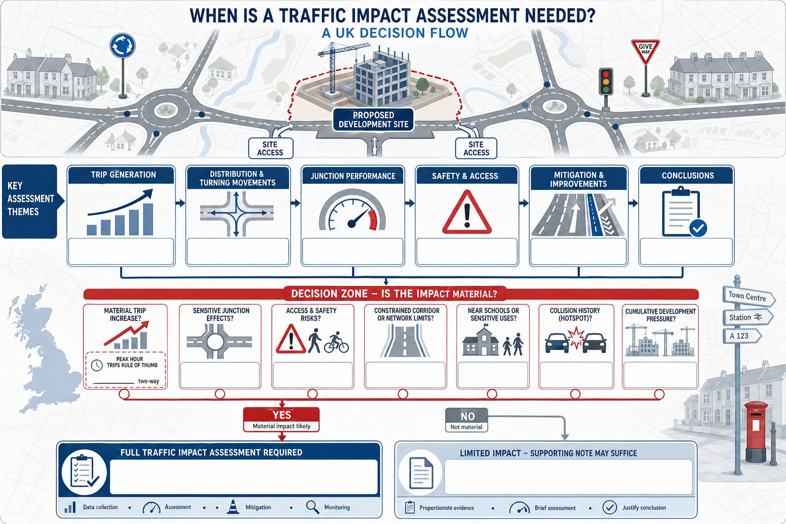
In the UK planning context, a TIA is commonly required where development may generate a material increase in trips, alter turning patterns, affect a sensitive junction, or introduce safety risks at the site access. A rough rule of thumb often used in practice is around 100 or more peak-hour vehicle trips, but that is not a universal legal trigger. Local planning authorities work to their own thresholds and local validation requirements.
That means a scheme with fewer trips can still need a TIA if it sits on a constrained corridor, near a school, beside a known collision cluster, or within an area already under cumulative pressure from committed development. Equally, some schemes may only need a lighter-touch document if impacts are clearly limited. In many cases, early traffic impact assessments scoping avoids expensive course-correction later.
How A Traffic Impact Assessment Differs From A Transport Statement And Transport Assessment
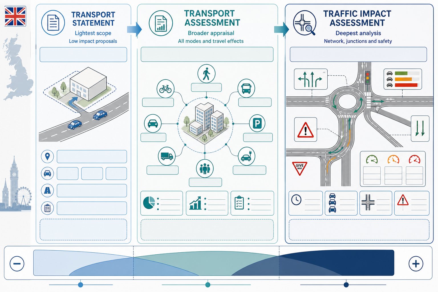
These three documents are often mentioned together, and sometimes used loosely in conversation, but they are not interchangeable.
A Transport Statement is the lightest-touch option. It is generally prepared for smaller, lower-impact proposals where the anticipated transport effects are limited and relatively straightforward. It usually summarises existing access conditions, likely trip levels and any modest operational issues, but it does not normally involve the same depth of modelling or junction testing as a full TIA.
A Transport Assessment is broader in scope. It looks at how people will travel to and from a development across all modes, not just private cars. That can include walking, cycling, bus access, parking strategy, servicing, accessibility and travel planning, alongside traffic effects. For many medium and larger developments, this wider appraisal is what authorities want because it supports policy compliance on sustainable transport as well as highway operation. The distinction is important when deciding whether a scheme needs a focused TIA, a broader transport assessment for developments, or both.
A Traffic Impact Assessment is narrower but deeper. Its emphasis is on network performance: traffic generation, routing, junction capacity, queueing, delay, access design and traffic-related safety. If officers are worried about a roundabout operating over capacity, rat-running on local streets, or turning movements at a priority junction, a TIA is usually the right tool.
In real projects, the boundaries overlap. A residential scheme may require a Transport Assessment with a substantial TIA chapter. A logistics site may need a heavily traffic-led package with supporting sustainable travel measures. The key is proportionality, not labels.
Which Developments Typically Trigger A Traffic Impact Assessment
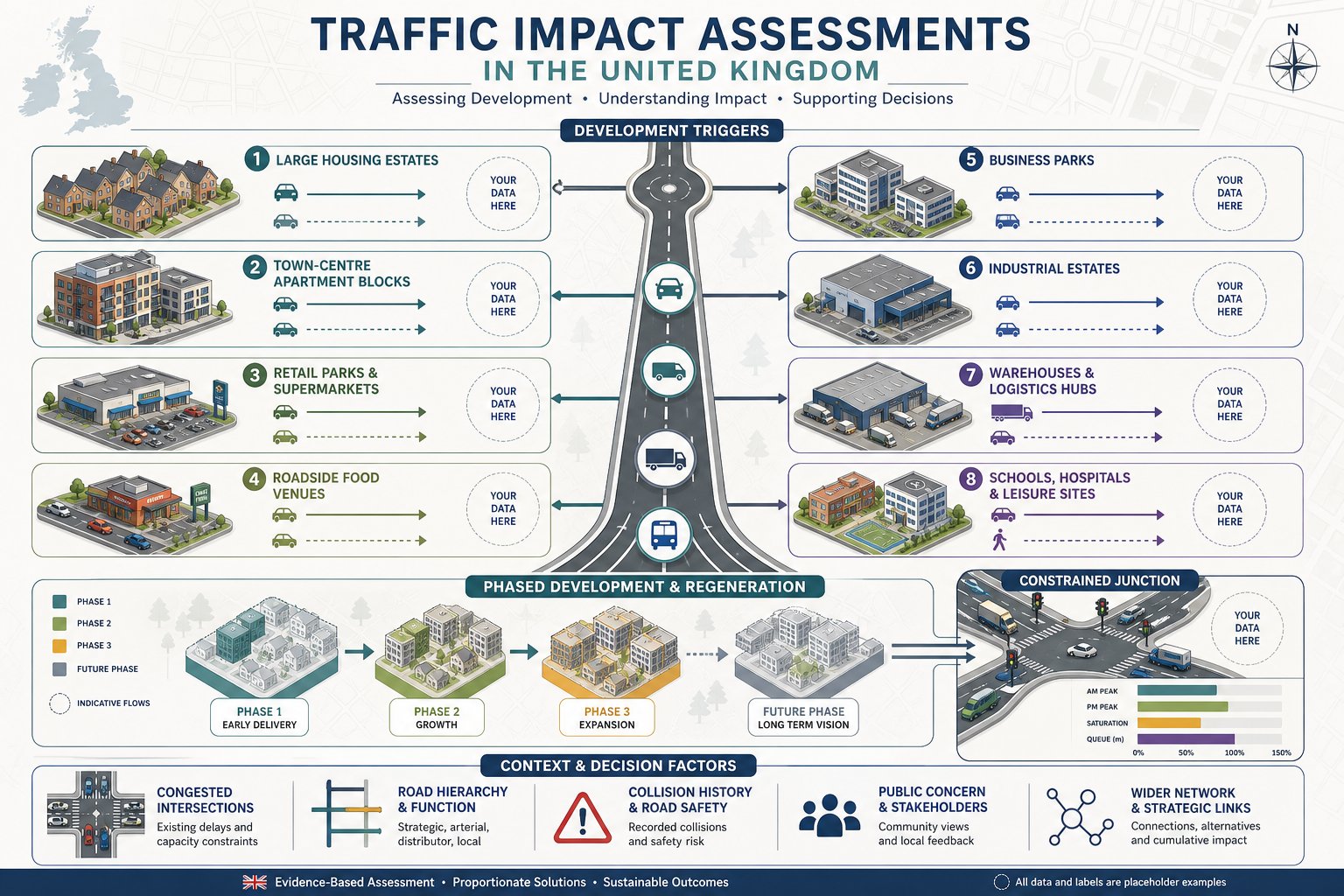
Some development types come up again and again in TIA work because their traffic effects are obvious, concentrated or politically sensitive.
Large housing developments are a common trigger, particularly where a site adds substantial peak-hour commuting traffic onto already stressed local junctions. Apartment schemes in town centres can also require detailed review where parking restraint, servicing activity or nearby signalised junctions create pressure. Retail parks, supermarkets and roadside food-led uses often generate sharp peaks, complex turning movements and weekend demand patterns that need testing rather than assumption.
Employment uses are another major category. Business parks, industrial estates, warehouses and logistics schemes can produce substantial two-way movements, including HGV traffic, at very specific times of day. Education, healthcare and leisure developments can be just as demanding, especially when arrivals and departures are highly concentrated or linked to school-run conditions.
Authorities also look closely at phased sites, regeneration areas and significant rezoning proposals. Even if one phase appears manageable in isolation, cumulative growth across the masterplan may justify a full assessment from the outset. That is particularly true where access is taken from a constrained network or where neighbouring allocated sites are expected to come forward within the assessment period.
In practice, the trigger is not only the land use but the local context: surrounding road hierarchy, existing congestion, collision record, public objection risk and whether the development changes how traffic interacts with the wider network.
How Local Planning Authorities Decide Whether A Full Assessment Is Needed
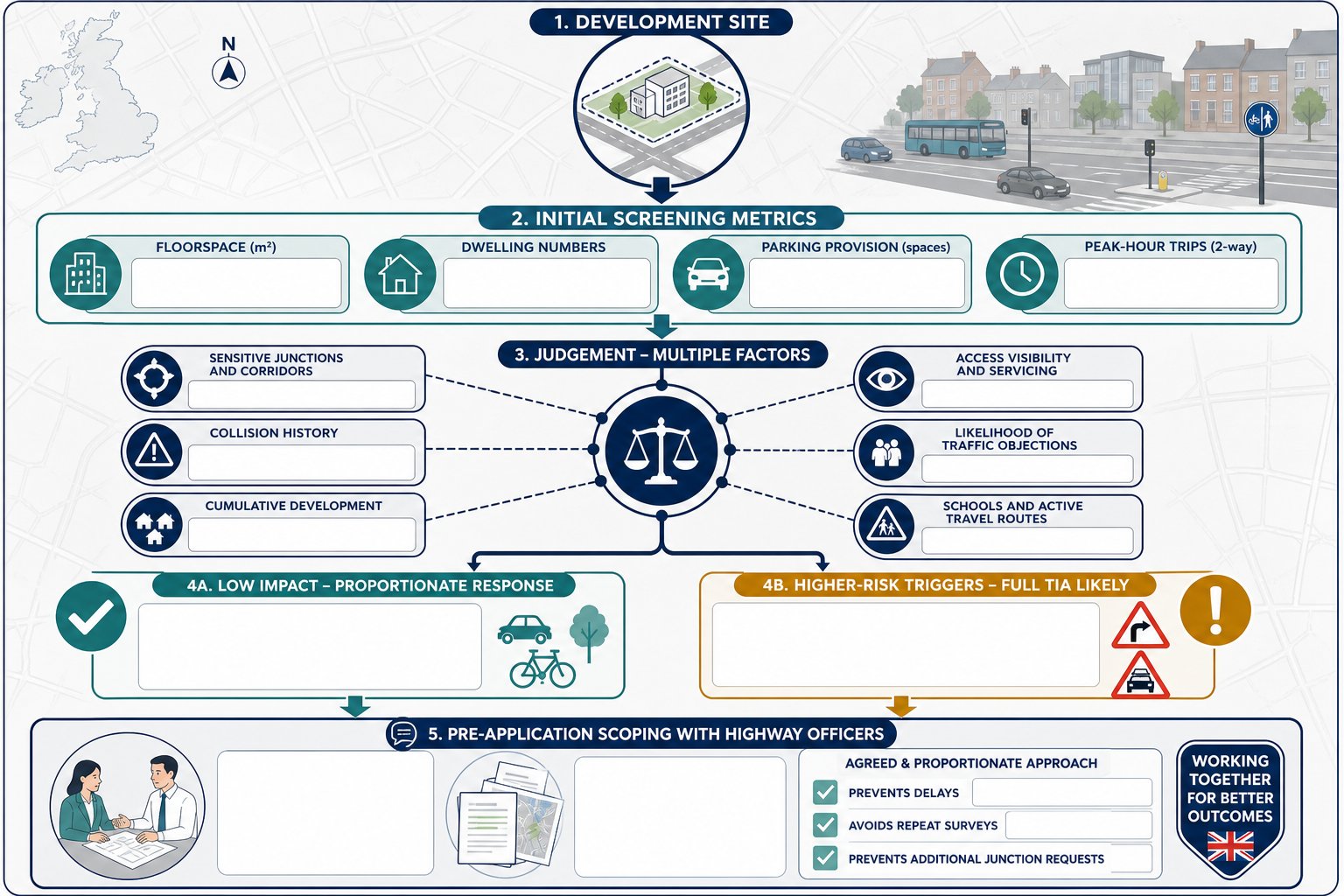
Local planning authorities typically start with thresholds, but they rarely stop there. Floorspace, dwelling numbers, parking provision and estimated peak-hour trips all help officers decide whether a proposal should be screened into a full assessment. Some councils publish local validation guidance: others rely more heavily on case-by-case judgement from transport officers or highway authorities.
Professional judgement matters because transport impact is rarely captured by one headline number. A site generating fewer than 100 peak-hour trips might still require detailed analysis if it connects to a difficult right-turn access, affects a school route, or sits close to a junction already operating with little spare capacity. Likewise, a modest development in a lightly trafficked location may justify a more proportionate response.
Authorities will usually look at several things together:
- sensitivity of nearby junctions and corridors
- recent collision patterns and road safety concerns
- cumulative impact from committed or allocated development
- access geometry, visibility and servicing demands
- whether the proposal is likely to attract objections on traffic grounds
This is why early scoping is so valuable. Agreeing the study scope with officers at pre-application stage can prevent the familiar planning delay: a report is submitted, transport comments return, extra junctions are requested, surveys have to be repeated, and the timetable slips by weeks. A concise agreed brief up front is often worth far more than a longer report later.
The Core Objectives Of A Traffic Impact Assessment
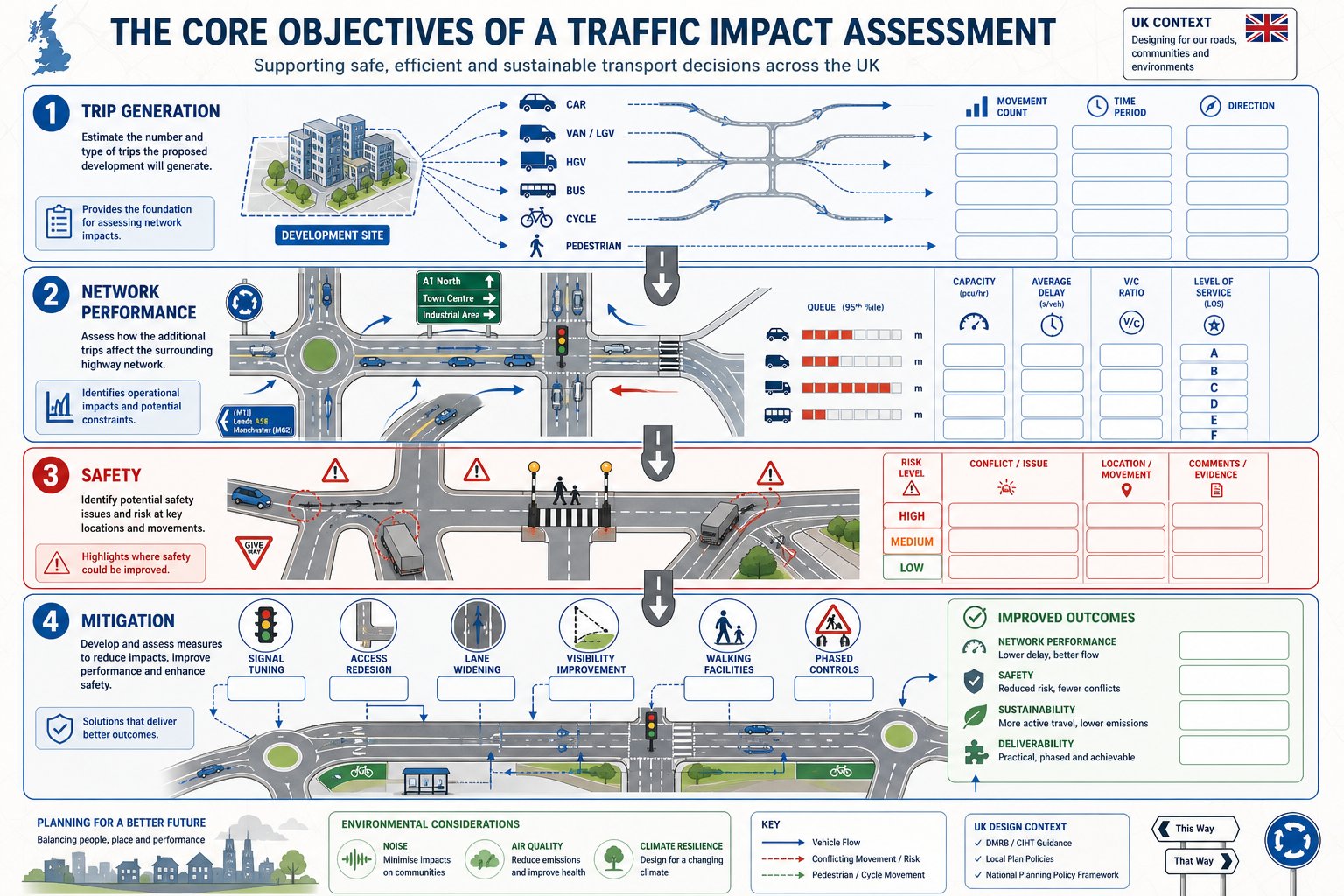
At its heart, a TIA is designed to give decision-makers enough confidence to judge whether transport impacts are acceptable and, if not, what should be done about them.
The first objective is to quantify the trips generated by the development. That includes identifying how many movements are likely to occur, when they happen, what vehicles are involved and where they are expected to go. For mixed-use or phased schemes, that can get quite nuanced quite quickly.
The second objective is to test performance on the surrounding network. We usually need to understand whether key links and junctions can accommodate the added demand in existing conditions, future baseline conditions and future conditions with the development in place. Capacity, queueing, delay, practical reserve capacity, volume-to-capacity ratios and level of service all come into play depending on the network type and the assessment tools used.
A third objective is safety. A scheme may appear acceptable on pure capacity terms and still raise concerns because of collision history, substandard geometry, pedestrian conflict or HGV manoeuvring. A robust TIA hence considers how traffic operation and road safety interact.
Finally, a TIA should identify mitigation that is reasonable, proportionate and deliverable. That might include access amendments, signal optimisation, localised widening, visibility improvements, travel measures, pedestrian facilities or phasing controls. On some projects, the TIA also sits alongside a wider environmental impact assessment where traffic effects feed into noise, air quality or environmental topics.
If a report does those four things well, it becomes a planning tool rather than just a technical obligation.
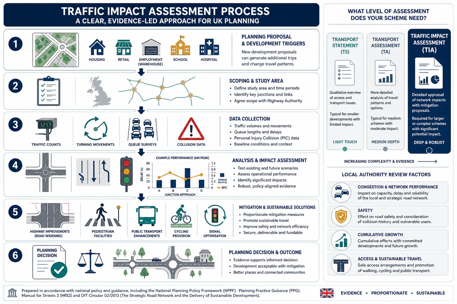
Key Stages In The Traffic Impact Assessment Process
Although every site has its own quirks, most traffic impact assessments follow a recognisable process.
First comes scoping. We define the development parameters, understand the local highway context, identify likely concerns and agree an assessment framework with the authority where possible. This part is often underestimated, but it is where the eventual credibility of the report is set.
Second comes data collection. That may include classified turning counts, automatic traffic counts, queue observations, speed data, parking stress review, collision records and review of committed development. If survey data is weak or out of date, the entire assessment becomes vulnerable.
Third is forecasting demand. We estimate trip generation, then distribute and assign those trips across the network using observed patterns, census or mobile data, gravity-style methods, or accepted reference sources. That creates the basis for modelling future flows.
Fourth is operational analysis. We test links and junctions under existing, future baseline and future with-development scenarios. Depending on the site, that might involve priority junction software, roundabout modelling, signal modelling, corridor review or microsimulation.
Fifth is mitigation. If impacts are material, we develop and test measures to address them. The best mitigation is usually practical, targeted and aligned with what can actually be delivered through planning conditions or obligations.
Finally, we report the evidence clearly enough for officers, consultees and committee members to follow. Dense technical work is fine: opaque technical work is not.
Scoping The Study Area, Assessment Years And Junctions To Be Tested
Scoping is where a TIA either becomes proportionate and persuasive, or drifts into argument later.
The study area should cover the roads and junctions that are genuinely likely to experience material development traffic. That usually means the site access, immediate frontage, main approach routes and any junctions where assigned traffic creates a meaningful percentage uplift or where existing sensitivity is already known. We do not need to test every junction in a district, but we do need to avoid obvious omissions.
Assessment years matter just as much. In most cases, we consider an existing or base year, an opening year and a future design year. We also compare a future baseline scenario without the development against a future scenario with the development. That distinction is crucial because planning decisions are not based on today’s traffic alone: they are based on the network conditions likely to exist when the scheme operates.
Committed development should also be included where appropriate. Ignoring nearby consented sites is one of the fastest ways to invite objections from the highway authority.
The choice of junctions to test should be evidence-led. If traffic assignment shows only trivial change at a location, extensive modelling may not be justified. But if a roundabout is already close to capacity, even a modest increase can become significant. We’ve found that careful, locally informed scoping, especially where authority thresholds differ from standard assumptions, saves both clients and councils a lot of needless back-and-forth.
What Data Is Needed For A Reliable Assessment
A reliable TIA depends on data that is current, relevant and transparent. When reports fall apart under scrutiny, it is often because the underlying evidence is patchy rather than because the calculations are especially controversial.
At minimum, we usually need a clear description of the development proposals: land use mix, gross floorspace, unit numbers, access strategy, servicing arrangements, parking provision and likely phasing. Without that, trip forecasts are built on sand.
Existing network data is equally important. That normally includes traffic counts on surrounding roads, turning movement surveys at key junctions, observed queue and delay conditions, speed environment, collision history and, where relevant, pedestrian or cycle flows. On constrained urban sites, kerbside activity, loading behaviour and parking stress can also matter more than headline link volumes.
Future-year inputs also need care. Background growth factors, committed developments, local plan allocations and planned highway changes all influence the baseline against which the scheme is judged. If these are omitted, the authority may reasonably argue that the model understates future pressure.
Data quality is not just about age: it is about representativeness. Holiday periods, abnormal roadworks, school closures or weather disruption can all distort survey results. And if a site sits in a fast-changing area, survey data from even a year ago may already need checking against present conditions. Strong analysis starts with honest inputs.
Traffic Surveys, Trip Generation And Distribution Methods
Survey choice should reflect the questions the TIA is trying to answer. Automatic traffic counts are useful for understanding daily profiles and road volumes over several days. Classified turning counts give the detail needed to test individual junctions in the weekday AM and PM peaks, and sometimes Saturday peaks for retail or leisure schemes. Queue surveys and journey time observations add context where operational stress is already evident.
Trip generation then converts the development proposal into forecast movements. That may rely on comparable sites, recognised databases, local surveys or accepted reference material such as ITE-based evidence where appropriate, though UK planning work usually demands careful local adjustment rather than blind transfer. Land use, location, parking restraint, public transport accessibility and internalisation all influence the final rates.
Distribution and assignment are where professional judgement becomes especially visible. We need to explain not just how many trips are generated, but where they are likely to travel and which routes they will use. That can be informed by observed turning patterns, census journey-to-work data, origin-destination information, gravity-style modelling and route logic based on the network itself.
Weak TIAs often stumble here. Unsupported trip rates, optimistic mode assumptions or implausible routing can undermine an otherwise well-presented report. Sound methods, clearly explained, make it easier for officers to agree conclusions and focus discussion on mitigation rather than methodology.
How Junction Capacity, Safety And Network Effects Are Assessed
Once flows have been established, the next step is to test what they mean in operation.
At junction level, we assess capacity and performance under several scenarios: existing conditions, future baseline without the development, and future with the development. Depending on junction type, that may involve priority junction assessment, roundabout modelling, signal analysis or more strategic corridor tools. The headline outputs often include queue lengths, delay, reserve capacity, degree of saturation and practical stress points during peak periods.
But capacity is only part of the picture. Safety assessment matters too. We review collision records, site access geometry, visibility, turning paths, crossing demand and compliance with relevant design principles. A junction with spare capacity can still be problematic if a proposed access creates poor manoeuvres or conflict with vulnerable road users.
Network effects can extend beyond one junction. Added traffic may influence rat-running, route choice, bus reliability, servicing interaction or performance at a linked set of signals. On larger schemes, cumulative effects across a corridor may be more important than a single arm’s model output.
This is also where local knowledge counts. Someone familiar with how a town centre actually operates in the school peak, or how a logistics route behaves under nearby motorway pressure, will often spot issues a spreadsheet misses. On regionally sensitive schemes, input from a specialist Traffic Engineer In the relevant authority area can make the assessment both sharper and more defensible.
Common Issues That Delay Planning Applications
Most planning delays linked to transport are not caused by exotic modelling disputes. They come from ordinary avoidable weaknesses.
The first is poor scoping. If the submitted report ignores an obviously sensitive junction, omits school-time conditions, or uses assessment years the authority does not accept, the review clock effectively resets. Officers ask for more work, the applicant commissions more surveys, and everyone loses time.
The second is stale or incomplete data. Surveys carried out during abnormal network conditions, with too short a count duration, or long before submission often attract justified challenge. The same goes for missing collision analysis or a failure to account for nearby committed schemes.
Third, trip generation and distribution can be under-evidenced. Authorities quickly spot rates that look too low, mode shares that feel aspirational rather than proven, or routing patterns that conveniently avoid constrained junctions. A polished report does not rescue weak assumptions.
Fourth, mitigation is often undercooked. Drawings may be too vague, swept paths unresolved, visibility unproven or highway works not coordinated with the land available for delivery. In that situation, even if officers accept there is a solution in principle, they may still hold back support.
And finally, there is plain readability. If the document is hard to follow, inconsistent between text and appendices, or overloaded with unexplained outputs, it creates uncertainty. In planning, uncertainty tends to slow everything down.
How To Prepare A Strong Traffic Impact Assessment For Planning Success
The strongest TIAs are rarely the longest. They are the ones that answer the authority’s actual questions with current evidence, proportionate testing and practical mitigation.
Start early. Pre-application engagement is not glamorous, but agreeing the study area, survey scope, peak periods, committed developments and modelling approach before submission can remove a surprising amount of later friction. Where a scheme sits in a complex planning context, that early alignment is often the difference between one transport consultation round and three.
Use robust data and explain assumptions plainly. If trip rates are adjusted, show why. If a junction is excluded, justify it. If mode share is expected to improve, link that expectation to site location, accessibility and credible measures rather than hope.
Compare scenarios clearly. Decision-makers should be able to track the story from existing conditions to future baseline and then to future with-development conditions without hunting through appendices. Well-labelled figures, concise summary tables and consistent scenario naming help more than people think.
Mitigation should be specific, deliverable and proportionate. Costly overdesign can be just as unhelpful as thin mitigation, especially where modest access changes, signal tweaks or travel planning can address the actual issue. For developers juggling wider planning documents, it also helps when the traffic case aligns neatly with related traffic impact assessments and broader transport assessment for work, rather than contradicting them.
In short, planning success usually follows from a report that is technically sound, locally aware and easy to interrogate.
Conclusion
Traffic impact assessments are, at their best, decision-making tools. They help us move the conversation away from vague concerns about congestion and towards evidence: how much traffic is likely to be generated, where it will go, what it will do at key junctions, whether safety is affected, and what mitigation is genuinely needed.
In 2026, that clarity matters more than ever. Local authorities are balancing growth, network resilience, road safety and cumulative development pressure, and they expect supporting transport evidence to be proportionate but rigorous. For applicants, the message is fairly simple: scope early, use current data, test the right locations, and make the report readable enough for non-technical decision-makers as well as highway officers.
When we get those basics right, a TIA becomes far more than a planning requirement. It becomes one of the clearest ways to show that a development is workable, responsible and ready to progress.
Frequently Asked Questions about Traffic Impact Assessments
What is a Traffic Impact Assessment (TIA) and why is it important for planning applications?
A Traffic Impact Assessment is a detailed study evaluating how a proposed development will affect the surrounding road network’s operation, safety, and efficiency. It is vital for planning as it provides evidence on traffic generation, network capacity, and safety, influencing whether a development proceeds or faces delays.
When is a Traffic Impact Assessment typically required?
TIAs are usually needed when a development generates around 100 or more peak-hour vehicle trips, exceeds certain size or floorspace thresholds, or is located in sensitive or constrained areas. Local planning authorities also consider site context, such as nearby schools, collision clusters, and cumulative traffic pressures.
How does a Traffic Impact Assessment differ from a Transport Statement or Transport Assessment?
A Transport Statement provides a brief overview for smaller developments with limited transport effects. A Transport Assessment covers all travel modes and broader accessibility issues typically for larger schemes. In contrast, a TIA focuses specifically on detailed traffic effects on junctions, capacity, delays, and safety concerns.
What are the core objectives and stages involved in preparing a Traffic Impact Assessment?
The core objectives include quantifying additional traffic, assessing network capacity and safety, and identifying proportionate mitigation measures. Key stages involve scoping the study area and years, collecting data, forecasting trips, analysing junction capacity and safety, proposing mitigation, and compiling a clear report.
Which types of developments often trigger the requirement for a Traffic Impact Assessment?
Large housing estates, apartment complexes, retail parks, supermarkets, business and logistics parks, education, healthcare, leisure facilities, and significant rezoning or phased masterplans commonly require TIAs due to their substantial or complex traffic impacts.
How can developers ensure a successful Traffic Impact Assessment to support planning approval?
Developers should engage early with local authorities to agree on scope and methods, use current and robust data, clearly compare traffic scenarios, and propose feasible, deliverable mitigation. Early scoping and a well-structured, readable TIA help prevent application delays and objections.