Brighton & Hove is not an easy place to plan for movement. The city is dense, hemmed in by the South Downs and the sea, busy throughout the year, and under constant pressure to reduce congestion, improve air quality, and support lower-carbon travel. That combination makes transport planning in Brighton and Hove far more than a technical planning appendix. In practice, it often becomes one of the documents that decides whether a scheme moves smoothly through the planning process or gets delayed by objections, requests for further evidence, or costly redesign.
For architects, developers, planning consultants, surveyors, legal teams and local authorities, the challenge is usually the same: proving that development can be safely accessed, sensibly serviced, and integrated into a transport network that already has little spare capacity. And because Brighton & Hove places strong emphasis on walking, cycling, buses, rail, accessibility and public realm, transport evidence has to do more than count vehicle trips. It needs to show a realistic understanding of local travel behaviour and current policy direction.
In this guide, we set out what matters in 2026: the policy framework, the development types most likely to trigger transport evidence, the difference between a Transport Statement, Transport Assessment and Travel Plan, and the practical issues that often shape planning outcomes. We also look at how strong, locally aware reporting can reduce risk and help applications stand up to scrutiny.
Why Transport Planning Matters In Brighton And Hove
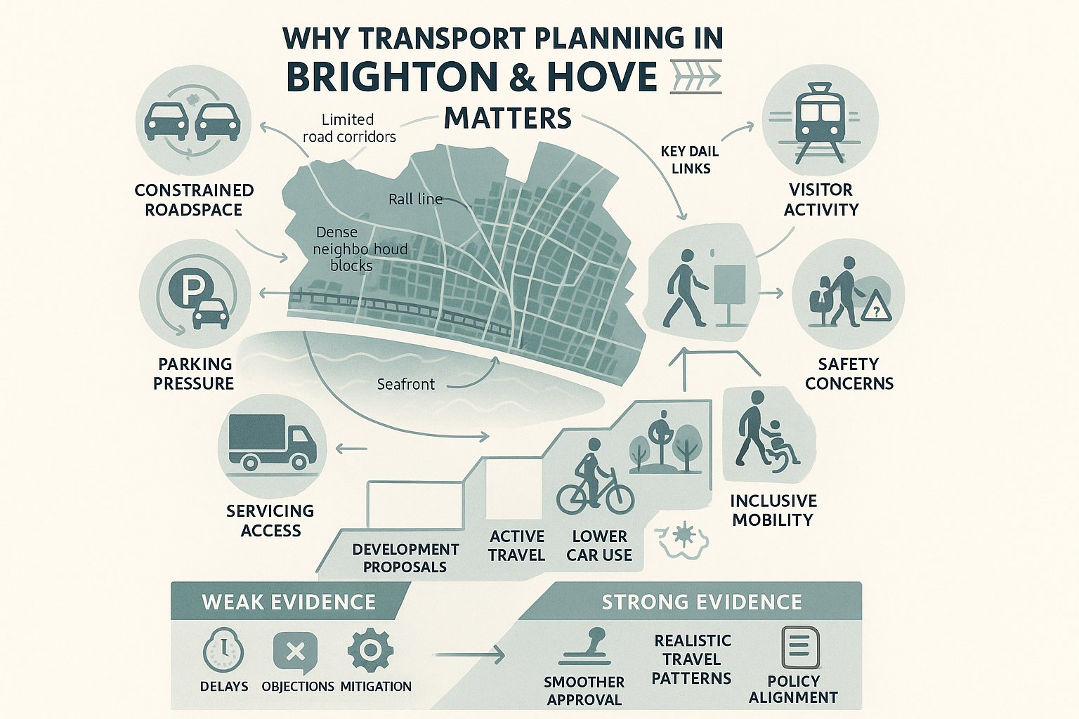
Transport planning matters in Brighton & Hove because development here sits within a network that is already constrained, heavily used, and politically important. The city has a compact urban form, strong bus patronage, key rail links, major visitor flows and neighbourhoods where roadspace is at a premium. That means even relatively modest proposals can raise questions about access, servicing, parking stress, safety, or cumulative traffic impact.
There is also a wider strategic reason. The direction of travel in local policy is clear: support growth, but do it in a way that reduces car dependency and improves the quality of the public realm. The emerging City Transport Plan 2035, alongside existing development plan policies and active travel strategies, points towards a more sustainable, inclusive and lower-carbon transport system. So when we prepare transport planning in Brighton and Hove, we are not just assessing whether vehicles can enter and leave a site. We are testing whether a proposal fits the city’s transport future.
For applicants, that matters commercially. Weak transport evidence can trigger additional information requests, prolonged negotiations over mitigation, or concerns from highways officers, planning officers and local residents. Strong evidence, by contrast, helps frame the scheme positively from the start. It shows that access has been thought through, that likely travel patterns are realistic, and that the development can support the city’s goals on air quality, liveability and mobility choice.
The Local Planning And Transport Policy Context
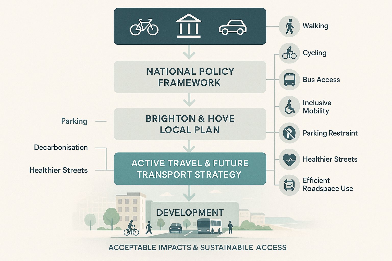
The policy context for transport planning in Brighton and Hove combines national planning tests with a distinctly local transport agenda. At national level, the National Planning Policy Framework remains central. It expects development to promote sustainable transport, provide safe and suitable access for all users, and only be refused on highways grounds where the residual cumulative impacts are severe. That wording is familiar, but in practice it places a premium on evidence quality. If an applicant wants to show impacts are acceptable, the technical case must be coherent.
Locally, Brighton & Hove City Council will consider proposals against the City Plan and saved or relevant Local Plan policies, supported by more detailed transport and movement guidance. The Local Cycling and Walking Infrastructure Plan is important where developments affect active travel routes or should contribute to improved connectivity. The draft City Transport Plan 2035 adds further weight to themes that are already shaping decisions: mode shift, healthier streets, decarbonisation, accessibility, reduced traffic dominance and more efficient use of limited roadspace.
For practitioners, the key point is that policy compliance is not just a box-ticking exercise. We need to align the transport narrative with the city’s stated priorities. A report that focuses narrowly on traffic engineering, while ignoring walking routes, bus access, cycle provision, inclusive design and parking restraint, can feel out of step very quickly. Good transport evidence reads the policy mood as well as the policy wording.
Key Development Types That Trigger Transport Evidence
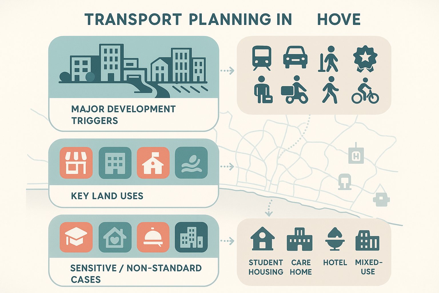
Not every planning application in Brighton & Hove needs a full transport package, but many schemes do require some form of transport evidence. Major residential development is the obvious example, particularly where schemes introduce meaningful trip generation, new access arrangements, basement parking, or pressure on surrounding streets. Flatted development in highly accessible locations may still need robust justification, especially if parking is limited and sustainable travel claims are being relied upon.
Retail, employment, education, healthcare and leisure schemes also frequently trigger assessment. These uses can create concentrated arrivals in the morning peak, lunchtime, evening or weekend periods, and they often generate different patterns for staff, visitors, deliveries and servicing. In Brighton & Hove, seafront and city-centre uses can be especially sensitive because they sit within busy, constrained corridors with competing demands from buses, pedestrians, cyclists, taxis, loading and tourism.
Some development types need closer scrutiny because standard assumptions do not always work well. Student accommodation, care homes, hotels, hospitality venues and mixed-use regeneration schemes can all have unusual travel profiles. The same is true for sites near rail stations, schools, hospitals or strategic junctions. In these cases, local context matters at least as much as scale. Even a relatively modest proposal may need transport input if it sits in a sensitive location, relies on constrained access, or could affect a corridor already under pressure.
When A Transport Statement, Transport Assessment, Or Travel Plan Is Needed
The distinction between a Transport Statement, a Transport Assessment and a Travel Plan sounds simple on paper, but the right choice depends on both the scale of development and the nature of local impacts.
A Transport Statement is usually suitable for smaller schemes with limited transport effects. It normally sets out site context, existing transport conditions, access arrangements, parking and servicing proposals, and a proportionate review of likely trip generation. In Brighton & Hove, a statement may still need to be more detailed than applicants expect if the site lies on a constrained street, near a busy junction, or within an area of parking stress.
A Transport Assessment is required where impacts are likely to be material. That tends to mean larger residential or commercial proposals, strategic redevelopment sites, or schemes that could affect junction performance, road safety, servicing, or sustainable travel infrastructure. A proper TA goes beyond trip estimates. It should test distribution, assignment, peak-hour effects, cumulative impact and mitigation, while linking all of that back to local policy objectives.
A Travel Plan is often expected for major or travel-intensive development and is commonly secured by condition or planning obligation. In this city, Travel Plans matter because policy is clearly geared towards mode shift. They should not be generic templates. We need realistic targets, meaningful measures, monitoring arrangements and a clear understanding of how residents, staff or visitors are actually likely to travel. Otherwise, they carry little weight in decision-making.
How Trip Generation And Traffic Impact Are Assessed
Trip generation is one of the first issues everyone looks for in a transport report, but in Brighton & Hove it cannot be approached mechanically. We usually start with TRICS or comparable database evidence, then test whether those comparables genuinely reflect the local context. A suburban edge-of-town benchmark with high parking provision may tell us very little about a central Brighton site with strong bus access, controlled parking and walkable daily services.
That is why local calibration matters. We often need to adjust assumptions to reflect the city’s relatively high use of buses and rail, lower car mode share in accessible locations, and the effect of parking restraint on travel behaviour. Census data, local survey evidence, committed development information and observed site characteristics can all help. The best assessments do not simply choose the lowest trip rate available: they explain why a particular rate is credible.
Traffic impact assessment then looks at when trips occur, where they are likely to go, and which parts of the network they would affect. In Brighton & Hove, this usually means close attention to peak periods, constrained corridors, seafront movement patterns, school-run interactions and junctions with little operational resilience. If the site is highly accessible, we also need to explain mode split carefully. Saying a development will be sustainable is not enough: the assumptions have to stand up technically and locally.
Junction Capacity, Network Performance, And Cumulative Impact
Once trips are established, the next step is to understand what they do to the network. Depending on the site, that may involve modelling priority junctions, roundabouts, signals, internal access points or servicing manoeuvres. We typically review queueing, delay, reserve capacity, blocking back risk and interactions with pedestrian and cycle movement. In a city with constrained geometry and limited roadspace, small changes can matter.
Cumulative impact is often where applications become more sensitive. Brighton & Hove has numerous regeneration sites, infill schemes and corridor improvements happening at the same time, so highway officers will usually want to know not just what one proposal does in isolation, but what happens when committed developments are added in. That assessment should be realistic rather than alarmist. The aim is to understand whether cumulative effects remain acceptable, and if not, what mitigation might be needed.
Mitigation can range from access design changes and signal optimisation to pedestrian improvements, cycle measures, loading controls, parking management or stronger Travel Plan commitments. But there is a practical point here: mitigation works best when identified early. If transport planning is left until the end of the design process, options narrow fast.
Sustainable Travel Expectations For New Development
Sustainable travel expectations in Brighton & Hove are not peripheral add-ons. They are central to whether a scheme is seen as policy-aligned. The city’s direction is towards walking, wheeling, cycling and public transport, with lower reliance on private cars wherever that is realistic. So applicants need to show, from the earliest stages, how a development supports that shift.
In practice, that means more than providing a cycle store and mentioning the nearest bus stop. We need to demonstrate that the site is genuinely capable of supporting sustainable journeys and that the scheme design makes those choices easy. That can involve direct pedestrian links, secure and convenient cycle parking, showers and lockers for employment uses, wayfinding, bus stop upgrades, car club provision, EV charging, and Travel Plan measures targeted to the end user.
The local context makes this especially important. Brighton & Hove has high demand for street space, established public transport use and strong policy support for healthier streets. Where a development proposes generous car parking in a highly accessible location, decision-makers are likely to ask why. Where it proposes low parking, they will want confidence that the sustainable alternatives are practical and inclusive. Either way, the transport strategy must be internally consistent.
For us, the strongest approach is usually to tie transport measures directly to the character of the place. A city-centre infill site, a suburban edge site and a seafront hospitality scheme will not need the same package. The principles are shared: the delivery should be site-specific.
Walking, Cycling, Public Transport, And Accessibility Appraisal
Accessibility appraisal is where the transport case becomes tangible. It should show what people can actually reach from the site, how comfortably they can do it, and whether the routes work for all users. In Brighton & Hove, that means paying attention to topography, crossing points, gradients, step-free access, footway width, lighting, personal security and the quality of links to bus stops and rail stations.
Walking and wheeling routes need to be continuous and legible. Cycling provision should connect sensibly to the local network and, where relevant, align with the principles behind the city’s cycling and walking infrastructure plans. Public transport assessment should look beyond distance alone. Service frequency, reliability, stop quality and onward connectivity all matter.
Inclusive design deserves real weight here. A route that is technically available but steep, cluttered or difficult to navigate may not be genuinely accessible. For planning purposes, that distinction is important. Strong transport planning in Brighton and Hove should hence combine mapping, narrative and on-the-ground judgement, rather than relying on generic accessibility software outputs alone.
Parking, Servicing, And Highway Design Considerations
Parking, servicing and highway design are often the points where planning theory meets operational reality. But sustainable a scheme may be in principle, it still needs to function day to day. Residents expect parking arrangements to be workable. Businesses need deliveries. Refuse vehicles need access. Emergency vehicles need clear movement. And all of that has to be resolved without undermining safety or local street conditions.
In Brighton & Hove, parking is particularly sensitive because many areas already experience significant on-street pressure. Local standards, controlled parking zones, car-free or low-car development principles and accessibility considerations all come into play. Cycle parking is equally important and should be convenient, secure and appropriately located, not hidden away as an afterthought. EV charging is now a routine consideration in most schemes, though it should sit within a wider strategy rather than act as a substitute for sustainable transport planning.
Servicing needs careful thought on constrained sites. We commonly test delivery vehicle sizes, turning paths, loading positions, refuse collection arrangements and any interaction with pedestrian routes, cycle tracks or bus movement. If servicing depends on awkward reversing, obstructive kerbside activity or informal manoeuvring, that will usually attract concern.
Highway design considerations can include access widths, radii, gradients, visibility, footway continuity, internal circulation and whether layouts could be adopted or otherwise accepted by the highway authority. These details may seem technical, but they often have a direct bearing on planning outcome.
Road Safety, Visibility, And Technical Design Checks
Road safety assessment should be evidence-led. A review of Personal Injury Collision data helps identify existing safety patterns and whether a proposal could worsen known risks. Around schools, busy urban junctions, seafront corridors or heavily trafficked local centres, that context can be especially important.
Visibility checks remain fundamental. We need to test whether emerging drivers, pedestrians and cyclists can see and be seen within the constraints of urban streets, parked vehicles, boundary treatments and topography. Gradients, tracking, swept path analysis and geometric design checks also play a major role, particularly where access is tight or servicing is complex.
The key is not just to show that a layout can theoretically work, but that it can work safely, repeatedly and without creating avoidable conflict. In our experience, well-presented technical drawings and concise, accurate supporting notes can make a big difference at this stage.
Common Transport Planning Challenges In Brighton And Hove
Brighton & Hove presents transport planning challenges that are very specific to the city. The first is limited roadspace. Many streets are already balancing heavy pedestrian activity, bus priority, cycle movement, loading demand, parking controls and through traffic, all within a constrained urban corridor. There is rarely a simple spare-capacity answer.
The second is geography. The sea to the south and the Downs to the north concentrate movement into a relatively narrow east-west urban strip, with some steep gradients affecting route choice and accessibility. That can make distribution patterns less flexible than desktop analysis first suggests.
The third is competing policy pressure. The city wants growth, housing delivery, economic activity and visitor appeal, but it also wants lower emissions, better air quality, safer streets and stronger liveability. Those aims are not contradictory, but they do create tension. A proposal that works operationally for cars may still be criticised if it weakens active travel conditions or fails to support mode shift.
Then there is kerbside management, which is becoming a challenge in its own right. Space for loading, taxis, disabled parking, buses, cycle parking and short-stay activity is limited. On dense or mixed-use sites, resolving those demands can be harder than junction modelling.
This is why generic reports struggle here. Transport planning in Brighton and Hove needs local judgement, realistic assumptions and a willingness to grapple with trade-offs rather than pretend they do not exist.
How To Prepare Strong Transport Evidence For A Planning Application
Strong transport evidence starts early. Before detailed design is fixed, it is worth scoping likely requirements with Brighton & Hove City Council and aligning the transport approach with the planning strategy, architecture and servicing concept. That early stage can save a surprising amount of time later, especially if there are access constraints, parking sensitivities or likely policy tensions.
The evidence itself should be proportionate but robust. That means using defensible survey data, relevant TRICS sites, realistic modal assumptions, clear plans and transparent methodology. If local characteristics justify departures from standard benchmarks, we should say so plainly and support them properly. Over-optimistic assumptions are usually easy to spot and hard to defend.
Presentation matters too. Officers, consultees and interested third parties need to follow the logic without digging through pages of unnecessary technical wording. The strongest reports tend to be concise, site-specific and joined-up with the wider application material. Access drawings, swept paths, parking layouts, cycle strategy, Travel Plan measures and mitigation proposals should all point in the same direction.
A good Travel Plan can add real value if it is specific, funded and capable of monitoring. So can an accessibility appraisal that reflects actual routes and barriers, not just distance circles on a map.
For many applicants, specialist input is worthwhile precisely because local thresholds and expectations vary. At ML Traffic, for example, the emphasis is on producing concise, accurate transport engineering reports quickly, shaped by more than 30 years of experience and tailored to local authority requirements. In a city like Brighton & Hove, that kind of localised, planning-aware evidence can make the difference between a report that merely exists and one that genuinely helps secure permission.
Conclusion
Transport planning in Brighton and Hove is rarely just about traffic numbers. It is about showing that development can fit a compact, ambitious and constrained city without undermining safety, accessibility or policy direction. That means understanding local transport priorities, choosing the right level of assessment, grounding trip generation in credible local evidence, and dealing honestly with parking, servicing, active travel and cumulative impact.
For architects, planners, lawyers, developers and councils, the practical lesson is straightforward: start early, scope carefully and build transport thinking into the scheme rather than bolting it on at the end. In 2026, successful applications in Brighton & Hove are the ones that demonstrate not only that a site can be accessed, but that it can support the city’s wider move towards low-carbon, public transport-led and people-focused mobility.
Done properly, transport evidence does more than answer objections. It helps shape better development.
Frequently Asked Questions about Transport Planning in Brighton and Hove
Why is transport planning particularly important in Brighton and Hove?
Transport planning in Brighton and Hove is vital due to its dense urban form, limited roadspace between the South Downs and the sea, and high bus and rail use. Effective planning supports reducing congestion, improving air quality, and driving the city’s goal for low-carbon, sustainable travel under the City Transport Plan 2035.
What types of developments typically require transport evidence in Brighton and Hove?
Major residential, retail, employment, education, healthcare, and leisure developments often require transport evidence. Special attention is given to places with unusual travel patterns such as student housing, care homes, and seafront hospitality, especially when located near busy corridors or constrained junctions.
When is a Transport Statement, Transport Assessment, or Travel Plan needed for planning in Brighton and Hove?
A Transport Statement is required for smaller schemes with modest impact, a Transport Assessment for larger or strategically significant proposals with considerable traffic effects, and a Travel Plan is necessary for all major or travel-intensive developments to support mode shift and sustainable transport compliance.
How is trip generation adapted for Brighton and Hove in transport planning?
Trip generation uses TRICS data calibrated with local survey evidence to reflect Brighton and Hove’s high bus and rail usage, parking restrictions, and pedestrian-friendly environment. This ensures traffic impact assessments consider realistic modal splits and local travel behaviour, not just generic benchmarks.
What sustainable travel measures are expected in new developments in Brighton and Hove?
Developments must promote walking, wheeling, cycling, and public transport over private car use. Measures include secure cycle parking, pedestrian-friendly access, EV charging points, car club provision, bus stop upgrades, and tailored Travel Plans with realistic targets aligned with the city’s active travel and carbon reduction goals.
How does transport planning address the challenges of limited roadspace and competing demands in Brighton and Hove?
Planning balances access for pedestrians, cyclists, buses, deliveries, and parking within constrained corridors by incorporating local transport policies, modelling junction and network performance, assessing cumulative impacts, and proposing mitigations like signal optimisation and kerbside management to maintain safety and liveability.