
Your site’s PTAL score is more than a static metric; it’s a powerful planning lever that can either unlock or severely restrict your development’s potential. Many professionals find the 0 to 6b scoring system confusing, particularly when strict parking restrictions in high PTAL areas threaten the commercial viability of a project. It’s frustrating when WebCAT 3.0 results don’t align with the practical reality of your site’s location. This PTAL public transport accessibility level guide provides the technical authority you need to interpret these results and ensure your planning application meets the rigorous standards of the London Plan 2021.
We’ll show you how to master the PTAL calculation to justify increased density and develop a robust parking strategy that satisfies local authorities. You’ll gain a clear understanding of how the latest 2023 data impacts your assessment and learn when it’s necessary to commission a detailed Transport Statement to challenge an unfavorable rating. This overview moves from the fundamental methodology to advanced strategies for optimizing site value, ensuring you have a reliable roadmap for your next London project.
Key Takeaways
- Understand how the 0 to 6b scoring system dictates your site’s density limits and commercial viability under the London Plan.
- Use this PTAL public transport accessibility level guide to master the technical components of walking distances and peak service frequencies.
- Learn why a score of 4 or higher often requires car-free housing and how to adapt your parking strategy to meet these standards.
- Identify common WebCAT errors and discover when a manual calculation is necessary to challenge an inaccurate rating during an appeal.
- See how professional Transport Statements and Parking Surveys ensure your project remains compliant with complex regional infrastructure regulations.
What Does PTAL Stand For? Understanding the 0-6b Scale
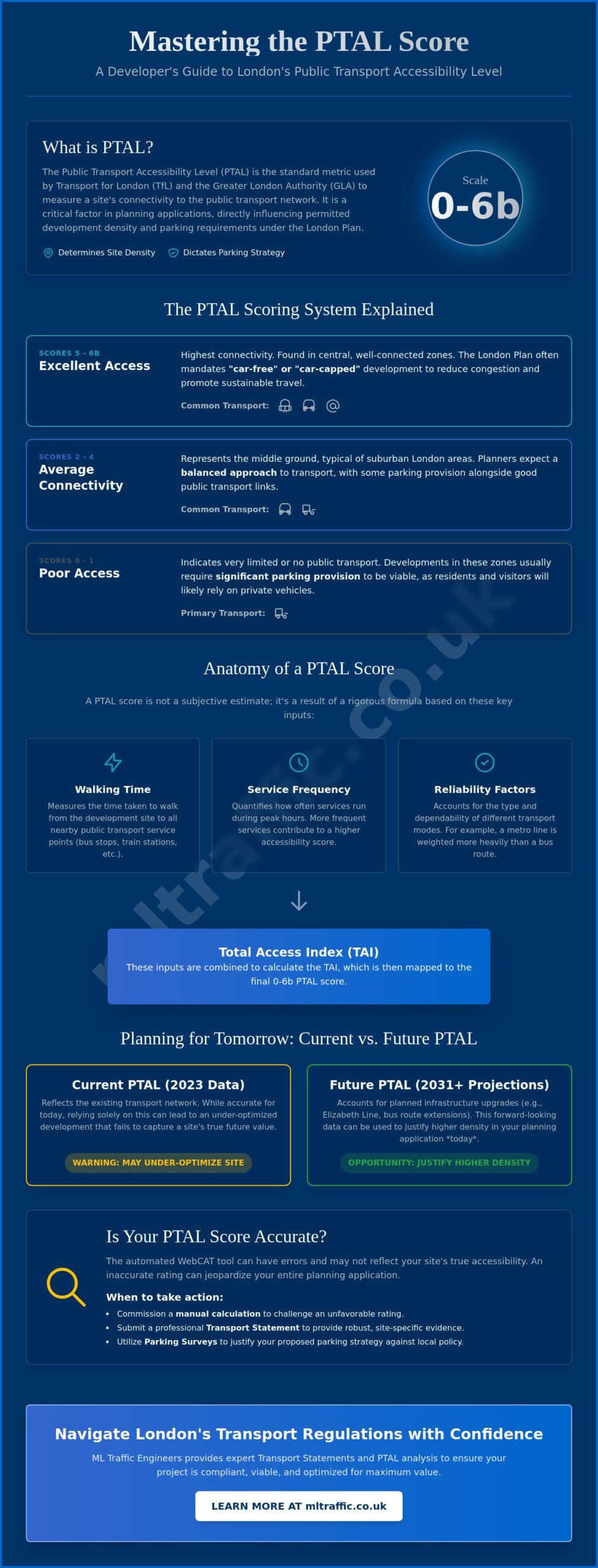
The term Public Transport Accessibility Level (PTAL) serves as the primary method used by the Greater London Authority (GLA) and Transport for London (TfL) to quantify the connectivity of a specific location to the public transport network. This methodology originated in the London Borough of Hammersmith and Fulham in 1992. Since then, it’s become the non-negotiable benchmark for urban planning across the capital. By providing a standardized PTAL public transport accessibility level guide for developers, the system ensures that housing density and parking provisions align with the actual capacity of local infrastructure.
To better understand the mechanics behind connectivity analysis, watch this technical overview:
The scoring system operates on a scale from 0 to 6b. A score of 0 indicates essentially no public transport access, while 6b represents the highest possible level of connectivity. The GLA uses these scores to enforce specific planning policies, particularly those found in the London Plan 2021. Precision is vital; a slight shift from a 4 to a 5 can fundamentally alter the requirements for your site’s parking strategy or residential density. When assessing site potential, our experts at ML Traffic Engineers UK integrate these scores into comprehensive Transport Statements to ensure regulatory compliance from day one.
Decoding the PTAL Grades
Planners categorize these scores into distinct tiers that dictate development constraints. The distinction between 6a and 6b is often the difference between high density and maximum density. 6b represents the absolute pinnacle of connectivity, where every transport mode is within immediate walking distance and operates at peak frequency.
- Scores 0-1: These reflect poor access. Developments in these zones usually require significant parking provision to remain viable, as residents will likely rely on private vehicles.
- Scores 2-4: This represents average connectivity. It’s the middle ground often found in suburban London, where a balanced approach to transport is expected.
- Scores 5-6b: These indicate excellent access. In these high-PTAL areas, the London Plan often mandates “car-free” or “car-capped” development strategies to reduce congestion and promote sustainable travel.
Current vs. Future PTAL Ratings
Connectivity isn’t static. WebCAT 3.0, launched in May 2024, allows developers to view both current 2023 data and projected ratings for future years such as 2031 or 2041. These projections account for major infrastructure projects like the Elizabeth Line or planned bus route extensions. Understanding the PTAL public transport accessibility level guide for future years is critical for long-term project viability. If a site’s score is scheduled to increase due to upcoming infrastructure, you can often use this data to justify higher density in your planning application today. Relying solely on current scores might result in an under-optimized development that fails to capture the site’s true future value.
How the PTAL Score is Calculated: The Technical Components
A PTAL score isn’t a subjective estimate; it’s the result of a rigorous mathematical formula that combines spatial data with real-time transport timetables. The calculation focuses on quantifying the effort required for a passenger to access the public transport network from a specific point. This PTAL public transport accessibility level guide examines the four main pillars of the calculation: walking time, service frequency, reliability factors, and the resulting Total Access Index. Precision in these metrics is vital, as even minor discrepancies in data can lead to a site being incorrectly categorized, potentially jeopardizing your planning application.
The process begins by identifying all available services within a set catchment area. Data professionals use the London Datastore PTAL information to pull current service frequencies and stop locations. This data forms the baseline for the Access Index (AI) for each transport mode. The final sum of these individual indices determines the site’s banding on the scale previously discussed. Accuracy is paramount, as the calculation weights different modes based on their consistency and availability.
The Importance of Walk Isochrones
Walking distances are strictly capped to reflect realistic passenger behavior and accessibility standards. For bus stops, the maximum walking distance is 640 meters, while for rail, tube, and DLR stations, the limit extends to 960 meters. These aren’t “as the crow flies” measurements. The calculation must account for physical barriers like rivers, railway lines, or gated communities that force longer walking routes. A PTAP is defined as the specific entrance of a station or an individual bus stop. If a barrier pushes the actual walking route beyond the 640m or 960m cap, that transport link is excluded from the calculation entirely. We often conduct Traffic Surveys to verify actual pedestrian routes when automated results seem to misrepresent the ground reality for ML Traffic Engineers UK clients.
Wait Times and Reliability
Service frequency is measured during the morning peak hour, specifically between 08:00 and 09:00. The calculation determines the Average Wait Time (AWT) based on the number of scheduled services. This AWT is halved and then added to the initial walking time to create a Total Travel Time. Reliability constants are then applied based on the mode of transport. Rail services are weighted as more reliable than buses because they aren’t subject to road traffic congestion. The calculation also utilizes the Dominant Mode principle, where the service with the highest individual index is weighted more heavily in the final sum than secondary services. This ensures that a site with one frequent, reliable train link is scored differently than a site with several infrequent bus routes.
The resulting Total Access Index is a cumulative value reflecting the total connectivity across all accessible modes. Because this index is so sensitive to walking route precision and timetable accuracy, developers must ensure their data is current. An outdated bus schedule or a newly opened station entrance can shift a site’s banding, directly impacting the housing density allowed by the Greater London Authority. If you suspect your automated score is unrepresentative, we recommend a bespoke review of your site’s technical components to protect your project’s density potential.
The Impact of PTAL on Planning Applications and Site Density
A site’s connectivity score directly dictates its commercial viability and overall development potential. Under the London Plan 2021, the Public Transport Accessibility Level (PTAL) serves as the primary metric for determining appropriate housing density and parking ratios. For developers, a higher score is often a prerequisite for maximizing the number of units per hectare. This PTAL public transport accessibility level guide highlights how a high rating can significantly reduce construction costs. By achieving a score that mandates car-free development, you can eliminate the need for expensive basement parking or extensive surface-level bays, freeing up more land for residential or commercial use.
While the latest London Plan has moved toward a design-led approach, the PTAL score remains the foundational evidence for justifying high-rise structures. In areas with scores of 5 or 6, the Greater London Authority (GLA) expects developments to optimize their footprint. Conversely, sites with lower scores must balance density with local character and existing infrastructure capacity. Precision here is non-negotiable. If your site is on the cusp of a higher banding, securing that higher score can unlock millions in additional development value by allowing for a more intensive use of the land.
PTAL and Residential Density Matrix
The historical density matrix used to provide a rigid calculation for units per hectare based on PTAL. Today, the focus is on “Good Growth,” which prioritizes inward and upward expansion in well-connected areas. High PTAL scores of 4 or above are typically seen as suitable for intensified development. In suburban zones with lower scores, developers must demonstrate how they’ll mitigate transport impacts without over-densifying the local environment. This often involves providing higher quality communal spaces or demonstrating that the site can support its own internal transport needs through robust Travel Plans.
Parking Provision and PTAL
Parking standards are perhaps the most contentious aspect of the planning process. In high-connectivity zones (PTAL 4 to 6), the default requirement is “car-free” development, excluding disabled person’s parking. This shift aims to reduce road congestion and improve air quality across the capital. For sites in PTAL 2 or 3 areas, limited parking is often permitted, but it must be carefully justified against borough-specific targets. We recommend conducting professional parking surveys to provide the empirical data needed to support your proposed parking ratios. This is especially critical when challenging a “car-free” mandate in a PTAL 4 zone where local on-street capacity might actually support limited residential parking without impacting the wider network.
To compensate for restricted car parking, high PTAL developments must provide enhanced cycle storage. The London Plan 2021 sets strict minimums for cycle parking, which often increase in intensity as the PTAL score rises. This holistic approach ensures that even with zero car spaces, the development remains accessible and functional for all residents. Our team can assist with Swept Path Analysis to ensure these cycle and service areas are navigable and compliant with the latest safety standards.
When WebCAT Isn’t Enough: Challenging and Refining Your Rating
While WebCAT 3.0 is the standard tool for assessing connectivity, its automated results aren’t always infallible. Because the tool utilizes 2023 data, it may not reflect recent bus frequency changes or newly opened station entrances. If the system suggests your site has a PTAL of 3, but a new pedestrian link has shortened the walking route to a nearby terminal, the automated result is unrepresentative. This PTAL public transport accessibility level guide emphasizes that developers don’t have to accept a generic score as the final word. Physical barriers often create connectivity gaps where a site is technically near a transport hub but requires a significant detour to reach it. In these instances, the automated tool fails to capture the practical reality of the location.
When WebCAT fails to represent site reality, we utilize the TfL spreadsheet macro for a manual calculation. This “Macro” approach allows for a granular assessment where we can input specific, verifiable data. We move the calculation “node” from a generic central point to the actual proposed site entrance. This shift can often increase the Access Index enough to move a site into a higher banding, such as from 4 to 5. It’s a technical process that requires rigorous evidence to be accepted by the Greater London Authority (GLA) during a planning appeal. Accuracy is vital here; if your data is even slightly off, the entire justification for higher density could collapse.
Manual PTAL Assessments
Commissioning a manual assessment from a transport consultant is essential for projects on the cusp of a higher rating. To challenge TfL’s automated scoring, you need empirical evidence. This includes current bus timetables, verified walking route maps, and on-site distance measurements. If a local service was temporarily suspended or its frequency reduced during the last TfL data sweep, a manual calculation can restore that connectivity to your score. We ensure every transport link is accounted for to provide a baseline that reflects the true accessibility of your development.
Improving Your Score Through Mitigation
Infrastructure design can actively boost your site’s score. If a development is on the edge of a PTAL 4, a Section 106 contribution to fund a new bus stop or a more direct pedestrian path can trigger a reclassification. We’ve managed cases where turning a PTAL 3 into a PTAL 4 through targeted infrastructure design completely changed the density allowances for a project. This proactive approach turns a regulatory hurdle into a strategic advantage, allowing for more units and reduced parking requirements. If your WebCAT results seem inaccurate, consult with our expert transport planners to perform a manual calculation and protect your site’s value.
Navigating London’s Transport Requirements with ML Traffic Engineers UK
A PTAL score is a vital metric, but it’s only one component of a successful planning application. We integrate this technical data into a professional Transport Statement to provide the necessary context for your site’s connectivity. ML Traffic Engineers UK provides the precision required for 2026 compliance by pairing PTAL analysis with Parking Surveys and Swept Path Analysis. This empirical evidence proves your site’s functionality to local authorities, demonstrating that the proposed density is supported by the surrounding infrastructure. High-quality technical reporting is the primary tool for reducing regulatory pressure and keeping your project on schedule.
Our team manages the full project lifecycle, from initial assessment to final submission. We liaise directly with TfL and Local Highway Authorities to resolve transport-related objections before they can stall your development. This proactive coordination ensures that technical data translates into planning approval. By providing a comprehensive, fully managed service, we act as a reliable partner that understands intricate regional regulations so you don’t have to. Our focus remains on delivering the data-driven evidence required for high-density London projects to succeed in a competitive landscape.
Comprehensive Transport Planning
We use the findings from this PTAL public transport accessibility level guide to craft effective Travel Plans. These plans are essential for high-density schemes where car-free living is mandated by the Greater London Authority. They ensure that even without residential parking, the site remains accessible and functional for all occupants. You can contact ML Traffic Engineers UK for a tailored accessibility review to identify potential score improvements. We prioritize clarity and the rapid delivery of information to ensure your site layout accommodates all required transport modes effectively.
Securing Planning Approval
We have a proven track record of overcoming transport objections by providing rigorous, data-driven evidence. Our technical reports satisfy the high standards of planning committees across all London Boroughs, regardless of the site’s initial connectivity rating. Whether you need to justify a parking strategy or argue for increased density, our expertise ensures your application is robust. Visit our resources page for more developer guides and technical insights into the evolving regulatory environment in the UK.
Maximizing Site Potential Through Precise Accessibility Analysis
Mastering the 0 to 6b scale is essential for any developer looking to optimize density and minimize parking restrictions under the London Plan 2021. This PTAL public transport accessibility level guide has outlined how technical precision in walking routes and service frequencies can fundamentally shift a project’s commercial viability. Whether you’re navigating the latest WebCAT 3.0 data or preparing a manual calculation to challenge an inaccurate rating, having the right evidence is non-negotiable. Accuracy in these early assessments prevents costly delays and ensures your site layout aligns with rigid infrastructure standards.
ML Traffic Engineers brings expert knowledge of TfL WebCAT and GLA policy to every project. We’re specialists in Transport Statements and Assessments, providing the data-driven clarity required to satisfy local authorities across all London Boroughs. Our proven track record across the capital ensures that your development remains compliant while achieving its maximum residential or commercial potential. We stand ready to manage the full technical lifecycle of your application, from initial data collection to final approval.
Secure your planning approval with a professional PTAL assessment from ML Traffic Engineers. We look forward to helping you navigate these complex regulations with confidence and precision.
Frequently Asked Questions
What is a good PTAL score for a new development?
A good score depends on your development goals, but a rating of 4 or higher is ideal for maximizing residential density. In central London, scores of 6a or 6b are standard and allow for the highest concentration of units per hectare. Lower scores are often acceptable in suburban areas where local character dictates a less intensive use of land and higher parking requirements.
Does a low PTAL score mean my planning application will be refused?
No, a low score doesn’t guarantee refusal, but it does impose stricter limits on density and requires higher parking provisions. You must provide a robust Transport Statement to justify your site’s safety and functionality in areas with poor transport links. Planning committees assess whether the proposed use of the site is appropriate for its current level of connectivity and infrastructure capacity.
How can I check the PTAL rating for my specific postcode?
You can check your rating using TfL’s WebCAT 3.0 tool by entering your postcode or specific coordinates. This interactive map provides current 2023 data and future projections for any location in Greater London. For planning applications, we recommend performing a site-specific calculation to ensure the automated results accurately reflect your proposed entrance points rather than a generic postcode center.
What is the difference between PTAL and TIM (Time Mapping)?
PTAL measures how easy it is to access the transport network, while TIM measures where you can go within a set timeframe. PTAL focuses specifically on walking distances to stops and service frequencies during peak hours. TIM provides a broader view of connectivity by showing the geographic reach of the network from your site, which is useful for assessing employment or amenity access.
Can PTAL scores change over time?
Yes, scores change as new infrastructure projects come online or bus route frequencies are adjusted. WebCAT 3.0 allows developers to view forecast data up to 2041 to account for major projects like the Elizabeth Line. If a site’s connectivity is scheduled to improve, you can often use future ratings to justify higher density in your current planning application, provided the infrastructure is committed.
Is PTAL used outside of London?
While PTAL was developed specifically for London, the methodology has been adapted for use in other regions like Greater Manchester and internationally in cities like Sydney. It remains the standard UK metric for quantifying transport connectivity in high-density urban environments. Use this PTAL public transport accessibility level guide to understand how these principles apply to regulatory compliance within the capital’s unique planning framework.
How does PTAL affect the number of parking spaces I can provide?
Higher scores generally mandate lower parking allowances to encourage sustainable travel. In areas with a score of 4 or higher, the London Plan 2021 typically requires car-free or car-capped development. Conversely, sites with scores of 0 or 1 are often allowed significant parking provision to accommodate residents who rely on private vehicles due to the lack of viable public transport alternatives.
Who calculates the PTAL score for a planning application?
While WebCAT provides an automated baseline, a qualified transport consultant should perform the final calculation for a planning application. We use technical macros to refine the data, ensuring that walking routes and service frequencies are current and accurate. Professional calculation is essential for identifying errors in automated tools that could negatively impact your site’s development potential or lead to planning objections.

Disclaimer
The content on mltraffic.co.uk, including all technical articles, guides, and resources, is provided for general informational and educational purposes only. It is not intended to constitute professional advice in traffic engineering, transportation planning, development approvals, or any other technical or legal field.
While ML Traffic Engineers makes every reasonable effort to ensure the accuracy, completeness, and timeliness of the information published, we do not provide any warranties or representations (express or implied) regarding its reliability, suitability, or availability for any particular purpose. Any reliance you place on the content is strictly at your own risk.
In no event shall ML Traffic Engineers, its directors, employees, authors, or affiliates be liable for any direct, indirect, incidental, special, consequential, or punitive damages (including, without limitation, loss of profits, data, or business opportunities) arising out of or in connection with the use of, or inability to use, any information provided on this website.
The articles and guides on this site are not a substitute for engaging a qualified, professional traffic engineer to assess your specific project requirements. For tailored advice, compliance assessments, or traffic engineering services, please contact a competent professional.
This disclaimer may be updated from time to time without notice. By accessing or using this website, you agree to be bound by the most current version of this disclaimer.