Urban regeneration rarely succeeds on architecture alone. A scheme can look excellent on the drawing board, promise new homes, jobs and public realm, and still stall because the street network doesn’t work for the place it is meant to serve. That is where regeneration highway design becomes critical.
In planning terms, we’re not simply arranging kerbs, lanes and signs. We’re shaping how a development connects to its surroundings, how people arrive, move and linger, and whether a highway authority is persuaded that the proposal is safe, deliverable and aligned with policy. For architects, planners, developers, surveyors and councils, that means streets have to do more than carry traffic. They have to support growth, improve accessibility, respect existing constraints and stand up to technical scrutiny.
In 2026, the expectation is clearer than ever: highway design must contribute to place-making as well as movement. That applies whether we’re dealing with a town-centre redevelopment, a mixed-use urban block, estate renewal, or a commercial site needing reconfigured access and servicing.
In this guide, we set out what regeneration highway design means in a planning context, when it becomes a formal requirement, which standards matter, and how to move from early concept to planning consent with fewer surprises. The aim is practical: help project teams design streets that unlock development, satisfy local authority expectations and remain deliverable on the ground.
What Regeneration Highway Design Means In A Planning Context
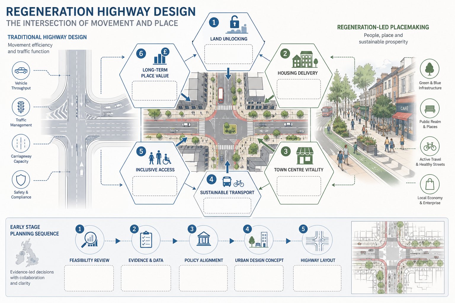
Regeneration highway design is the planning and design of streets, junctions and access arrangements so they actively support renewal, not merely traffic flow. In other words, the highway becomes part of the development strategy. It helps unlock land, improve movement, support economic activity and create a better urban environment.
That distinction matters in planning. Traditional highway thinking often focused heavily on vehicle capacity and standards compliance. Regeneration schemes still need safe and efficient operation, of course, but they are usually judged against a wider set of objectives: housing delivery, town centre vitality, public realm quality, sustainable transport, inclusive access and long-term place value.
So when we talk about regeneration highway design, we’re usually talking about a context-sensitive approach. The right answer in a constrained town centre will not look the same as the right answer on an edge-of-settlement allocation. Highway geometry, crossing points, servicing strategy, parking layout and frontage treatment all need to respond to the physical, economic and social setting.
This is also why early technical input matters. A highway proposal that is technically compliant but tone-deaf to the place often struggles in planning. A better route is to align transport strategy with urban design from the outset, using evidence and policy to show how movement and place can work together. On complex schemes, that often starts with a robust feasibility study highway review before fixed layouts harden into assumptions.
How Highway Design Supports Regeneration Objectives
Good highway design can make the difference between a scheme that technically functions and one that genuinely changes an area for the better. In regeneration projects, streets are often the framework that ties land uses together. They influence development value, occupier confidence, pedestrian activity and the quality of everyday experience.
At a practical level, highway design supports regeneration by improving connectivity to and through a site. That might mean opening up a previously isolated parcel, reducing severance around a town centre edge, rationalising awkward servicing movements, or making public transport access more attractive. In many cases, it also means rebalancing road space so walking and cycling are realistic, not token gestures.
Highway interventions can also support viability. Better access can increase developable area, improve frontage quality, and make phased delivery easier. Where schemes include retail, leisure or mixed-use components, the design of the street often affects dwell time, visibility and footfall just as much as the building layout does.
For planning purposes, the strongest regeneration highway design schemes are the ones that clearly link technical decisions to policy outcomes. If a crossing is moved, there should be a reason tied to desire lines and inclusivity. If carriageway space is reallocated, there should be a reason tied to place quality, safety or modal shift. That clear chain of logic is what helps authorities, design teams and stakeholders stay aligned.
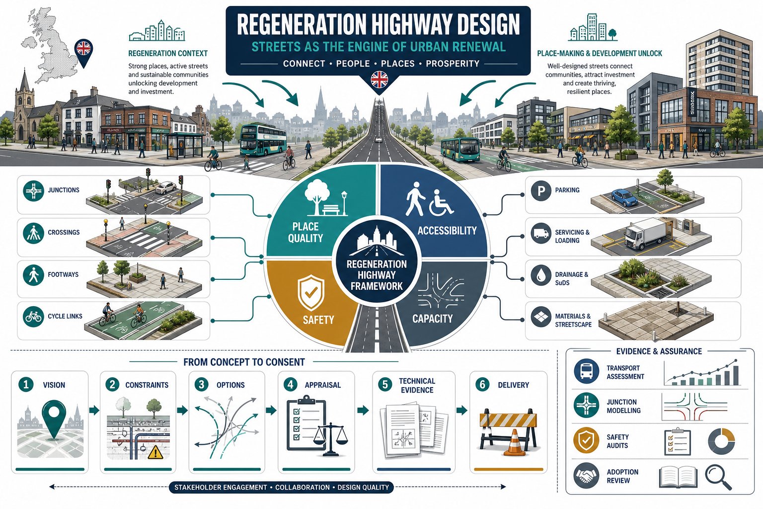
Place Quality, Accessibility, Safety, And Capacity
These four themes sit at the centre of almost every regeneration highway discussion, and they need balancing rather than treating in isolation.
Place quality is about more than appearance. It includes frontage activity, comfort, enclosure, tree planting, materials, crossing simplicity and whether the street feels like part of the neighbourhood rather than a transport corridor cutting through it.
Accessibility means access for everyone: pedestrians, wheelchair users, cyclists, bus passengers, delivery vehicles and drivers. Inclusive design is not optional. Crossing gradients, tactile paving, footway widths, turning requirements and dropped kerbs all matter, especially in older urban areas where existing conditions are awkward.
Safety remains fundamental. That includes collision risk, visibility, speed environment, pedestrian conflict points, cycle safety and the legibility of layouts. Regeneration sites often attract more varied users than conventional highway schemes, so the design must be forgiving and intuitive.
Capacity still matters, but it should be considered in context. The objective is rarely maximum vehicle throughput at any cost. More often, we need an acceptable level of network performance that does not undermine the place-making aims of the development. That is why our highway infrastructure design approach on urban schemes tends to test movement and placemaking together rather than as separate workstreams.
When A Regeneration Scheme Triggers Highway Design Requirements
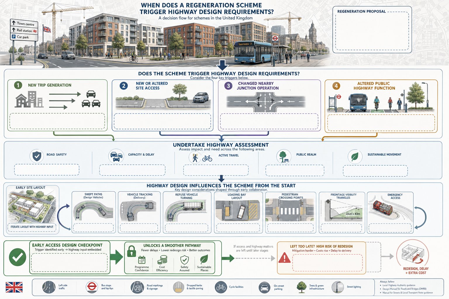
Not every regeneration proposal requires major off-site works, but many do trigger formal highway design requirements. The trigger is usually one of four things: the scheme generates material new trips, requires a new or altered access, changes the operation of nearby junctions, or affects the way public highway space functions.
In planning terms, that can arise on relatively modest schemes as well as large masterplans. A town-centre conversion may trigger servicing, parking and pedestrian access issues. A mixed-use redevelopment may require junction upgrades, bus stop changes and cycle connections. Estate renewal can involve reconfigured streets, stopping-up, emergency access checks and changes to adoption responsibilities.
The highway authority will typically want to know whether the development can be accessed safely, whether surrounding roads can accommodate additional demand, and whether the scheme aligns with local policy on active travel, public realm and sustainable movement. If the answer is uncertain, further design and technical evidence quickly become necessary.
A common mistake is assuming highway work begins only once the architectural layout is settled. In reality, access, swept paths, vehicle tracking, refuse strategy, loading arrangements and crossing locations often influence the layout from day one. That is especially true where constrained frontages, visibility limitations or competing land uses are in play.
Where development depends on a new or amended access arrangement, early access design highway input can save a lot of redesign later. It helps establish whether the principle is workable before the scheme becomes politically or financially committed to a layout that the authority may not support.
Key Planning, Design, And Adoption Standards To Consider
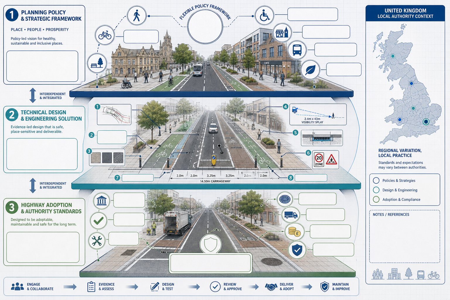
Regeneration highway schemes sit at the junction of planning policy, technical design guidance and highway authority practice. That sounds obvious, but many delays happen because teams focus on only one of those layers.
The planning layer asks whether the proposal supports policy objectives: sustainable transport, good design, healthy streets, town centre renewal, accessibility and deliverability. The technical layer deals with geometry, visibility, tracking, drainage, structures, signs, materials, road safety and operational performance. The adoption layer asks a different question again: if works are to become maintainable public highway, are the authority’s standards and processes actually being met?
On urban regeneration projects, flexibility is often available, but it has to be justified. Authorities may accept departures from standard dimensions or layouts where context demands it, particularly in historic or constrained areas. But they will still expect a defensible rationale, evidence that risks are understood, and confidence that maintenance and safety issues are addressed.
This is where project teams benefit from bringing planning and technical reporting together rather than treating them as separate silos. We’ve found that concise, authority-aware reporting tends to work best, especially where local thresholds, committee sensitivities and adoption concerns differ from one borough or county to another.
National Policy, Local Standards, And Highway Authority Expectations
National policy increasingly encourages transport design that supports sustainable development and responds to local character rather than imposing a one-size-fits-all highway template. That gives room for intelligent design, but not for vague design.
Local plans, area action plans and supplementary guidance often add another layer, setting expectations around street hierarchy, public realm, parking restraint, servicing hours, cycle provision and town centre movement priorities. In regeneration areas, these local documents can be more influential than generic standards because they reflect the political and spatial priorities of the place.
Then there is the highway authority itself. Its development management, adoption and technical approval teams will usually have specific expectations on swept paths, refuse access, tracking, construction details, drainage strategy, visibility, commuted sums and future maintenance liability. If a scheme ignores those expectations until late in the process, approval can drift.
On larger or more commercially sensitive sites, specialist input from Highway Design Consultants: helps bridge those layers. And where proposals hinge on node performance or signal changes, engaging Junction Design Consultants: early can make the difference between a concept that looks plausible and one that stands up under review.
Core Design Elements In Regeneration Highway Schemes
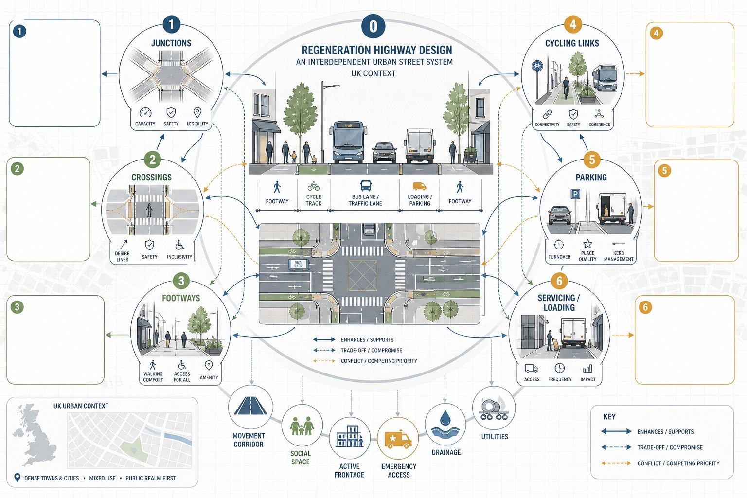
The physical components of regeneration highway design are familiar enough: junctions, crossings, footways, cycle facilities, parking, loading, servicing, drainage and street materials. What changes on regeneration projects is the level of interdependence between them.
A widened footway may reduce loading space. A new tree line may affect visibility or utility corridors. A relocated bus stop may alter crossing desire lines. A compact junction might improve urban character but introduce tracking constraints for servicing vehicles. Good design works through these interactions rather than treating each item as a separate drawing package.
In most regeneration schemes, the street also has to perform several roles at once. It may be a movement corridor, a social space, a frontage for active ground-floor uses, an emergency route, a servicing zone and a route for drainage and utilities. That complexity is exactly why early option testing matters.
There is rarely a single textbook solution. The right arrangement depends on land use intensity, frontage activity, traffic composition, local policy, adoption intentions and the existing urban grain. On employment-led projects, Commercial Development Highway issues often dominate, while residential-led schemes may focus more heavily on frontage, crossings and liveability.
Junctions, Crossings, Footways, Cycling Links, Parking, And Servicing
Junctions are often the most scrutinised feature because they affect capacity, safety and first impressions of the scheme. In regeneration areas, compact forms, signal optimisation or revised priorities can be preferable to highway-heavy layouts that consume valuable frontage.
Crossings should follow desire lines, not just leftover space. Signal-controlled crossings, zebras and side-road entry treatments all have a role, but the best option depends on speeds, flows, user profiles and surrounding land uses.
Footways need continuity, comfort and width. In practice, that means dealing carefully with dropped crossings, private accesses, street furniture and loading pinch points.
Cycling links should be coherent and direct. A short painted fragment that disappears at the difficult bit is not a regeneration strategy. Authorities increasingly expect legible, safe connections to surrounding routes.
Parking should support the land use without overwhelming the public realm. That includes disabled provision, short-stay demand, cycle parking and the management of kerbside space.
Servicing can make or break urban schemes. If loading happens in the wrong place or at the wrong time, pedestrian comfort and cycle safety quickly suffer. These details often look minor in planning packs but they are exactly the details officers and authorities probe.
The Role Of Transport Assessments And Supporting Technical Evidence
A well-designed street concept is not enough on its own. Planning decisions on regeneration projects usually depend on the supporting evidence that explains what the scheme will do to the network, how people will travel, and what mitigation is needed.
For larger schemes, that normally means a Transport Assessment, often accompanied by a Travel Plan. The TA should quantify trip generation, mode split assumptions, distribution and assignment, junction effects, parking demand and mitigation. But on regeneration sites, the better TAs do something more useful than that: they explain how transport impacts and place outcomes have been weighed together.
Supporting evidence may include junction modelling, road safety audits, walking and cycling audits, delivery and servicing plans, construction logistics information, parking surveys and tracking analysis. The exact package depends on scale and local thresholds, but the principle is consistent: the authority needs confidence that the proposal is evidence-led rather than aspirational.
This is where speed and accuracy matter. Authorities can usually spot generic reporting very quickly. They respond better to concise technical work that reflects their local policy framework, network sensitivities and validation expectations. That is one reason firms with long experience in authority-specific planning submissions, including teams like ours at ML Traffic, tend to focus on proportionate evidence rather than inflated reporting.
Where the highway strategy is still evolving, a staged approach can work well: initial scoping, concept testing, then fuller assessment once the preferred scheme has matured. That avoids overcommitting to assumptions too early while still giving planners and designers a solid technical base.
Designing For Existing Constraints In Urban Regeneration Areas
Urban regeneration rarely starts on a clean slate. More often, we inherit narrow corridors, irregular plots, legacy accesses, buried services, retaining structures, level differences, listed frontages, awkward bus movements and local political sensitivities. The challenge is not removing all constraints. It is designing intelligently through them.
In these settings, the temptation is to force a standard layout into a non-standard context. That usually produces strained geometry, poor public realm and difficult conversations with the authority. A better approach is to understand which standards are essential, which are flexible, and where the real operational risks sit.
Existing constraints also affect deliverability. A layout that looks neat in plan may fail once utility diversion costs, access rights, retaining requirements or frontage servicing realities are properly understood. So the design process needs to test buildability as well as planning acceptability.
This is especially important in dense urban centres, where one small geometric change can affect basement access, disabled parking, refuse collection, café spill-out space and drainage strategy all at once. Teams that treat highway design as part of the wider regeneration system tend to handle these trade-offs better than teams working in sequence.
Utilities, Frontage Access, Public Realm, Levels, And Construction Phasing
Utilities are a classic programme risk. Existing apparatus can limit tree pits, signal equipment, drainage runs, kerb lines and crossing foundations. Early C2 enquiries help, but real coordination often needs deeper investigation.
Frontage access has to work for occupiers and residents, not just on a tracking drawing. Short-stay drop-off, servicing windows, emergency access and threshold protection all matter in lived operation.
Public realm should not be the leftover strip after vehicle design is done. Materials, clutter reduction, seating, planting and lighting all influence whether regeneration feels genuine or cosmetic.
Levels can be surprisingly tricky. Thresholds to existing buildings, basement ramps, drainage falls and accessible gradients often compete. In retrofit streets, they need very careful resolution.
Construction phasing is the final test of realism. If the scheme cannot maintain safe access, servicing and reasonable network function during works, delay is almost built in. On complex sites, input from highway design consultants Birmingham: or similarly local teams can be particularly valuable where authority practice and town-centre conditions are very place-specific.
Common Risks That Delay Approval Or Delivery
Most delayed regeneration schemes are not undone by one dramatic flaw. They drift because several smaller issues were left unresolved until they became planning objections, technical queries or procurement problems.
One common risk is over-prioritising vehicle capacity at the expense of place quality and active travel. A layout may model adequately and still face resistance because it undermines the wider regeneration case. Another is the reverse: a very attractive concept with weak evidence on operation, servicing or safety.
Late engagement with the highway authority is another regular problem. If adoption, visibility, junction form, drainage or commuted sums are only discussed once the application is ready to submit, programme pressure rises immediately. The same applies where local design guidance has been skimmed rather than properly absorbed.
Technical evidence can also cause delay when it is incomplete, generic or inconsistent across documents. We often see planning statements, transport assessments, delivery plans and engineering drawings describing slightly different schemes. Authorities notice that.
Then there are physical constraints: utility diversions that are more extensive than expected, third-party land needs, visibility splays crossing land outside control, and maintenance burdens that no authority wants to inherit.
The practical answer is not endless reporting. It is disciplined coordination: one coherent highway strategy, tested early, explained clearly and updated consistently as the scheme evolves. That usually saves far more time than trying to repair contradictions after submission.
A Practical Process For Taking A Scheme From Concept To Consent
The cleanest way to approach regeneration highway design is through a staged process that reflects both planning risk and engineering reality.
First, define the problem and the vision. We need to be clear what the scheme is trying to achieve: unlock housing, improve a town centre edge, support employment floorspace, remove severance, upgrade public realm, or all of the above. That vision should be tied to local policy from the start.
Second, establish the baseline and constraints. This means traffic conditions, user movements, collision history, nearby developments, utilities, levels, frontage activity, servicing patterns, land ownership and heritage or townscape sensitivities. If this step is rushed, later design choices become guesswork.
Third, develop options. Different street typologies, access points, junction forms, crossing arrangements and parking strategies should be explored before the team settles on a preferred layout. Optioneering is where context-sensitive flexibility earns its keep.
Fourth, appraise and select. The chosen option should be defensible against movement, place, safety, environmental and viability criteria. Not perfect in every respect, but clearly the best-balanced solution.
Fifth, prepare detailed technical material. That may include a TA, Travel Plan, modelling, tracking, road safety audit input, drainage coordination and adoption discussions. This is where regeneration highway design moves from concept language to consent-ready evidence.
Sixth, agree the route to delivery. Conditions, Section 278 or 38 mechanisms, commuted sums, phasing, temporary traffic management and construction logistics all need clarity before consent turns into implementation.
Get that sequence right and approval becomes far more predictable. Not effortless, never that, but grounded in a scheme that makes sense on paper and on site.
The strongest regeneration projects are the ones where highways are treated neither as an afterthought nor as a purely technical hurdle. They are designed as part of the place itself. When we do that well, streets stop being the thing that delays regeneration and start becoming one of the main reasons it succeeds.
Frequently Asked Questions about Regeneration Highway Design
What is regeneration highway design in a planning context?
Regeneration highway design involves planning streets and highways to actively support urban renewal by enhancing place quality, accessibility, safety, and economic vitality, rather than solely focusing on vehicle movement.
How does regeneration highway design support urban regeneration objectives?
It improves connectivity and access for all transport modes, balances road capacity with liveability and safety, enhances streetscapes and public realm, and facilitates development viability and economic activity.
When does a regeneration scheme require formal highway design input?
Formal highway design is needed when a scheme generates new trips, alters access points, affects junction operations, or changes public highway functions such as parking or servicing arrangements.
Which core elements are involved in regeneration highway schemes?
Key elements include junctions designed for safety and capacity, pedestrian crossings aligned with desire lines, continuous footways, coherent cycling links, managed parking, and integrated servicing to support mixed-use activity.
Why is early engagement with highway authorities important in regeneration highway design?
Early engagement helps align designs with local policies and technical standards, identifies constraints, reduces redesign risks, and ensures deliverability and approval for planning consent.
What common challenges can delay regeneration highway design approval?
Delays often stem from ignoring local place-making policies, overemphasising vehicle capacity, incomplete or inconsistent technical evidence, late authority engagement, unresolved utilities, or maintenance liabilities.