A good planning strategy can unravel surprisingly quickly when the highway position has been guessed rather than tested. We’ve seen it happen: a site looks promising on a red-line plan, the development brief stacks up commercially, and then an awkward access geometry, poor visibility, third-party land strip or overstretched junction turns into the issue that slows everything down.
That is exactly where a feasibility study highway engineering process earns its keep. At the earliest stage, it helps us work out whether a development or road proposal can be served safely, practically and in a way that a highway authority is likely to accept. Not in theory. In the messy real-world conditions of boundaries, levels, traffic, frontage activity, legal constraints and local policy.
For architects, planners, surveyors, lawyers, developers and councils, that early clarity matters. It can influence land deals, masterplanning, application strategy, site value and programme risk long before a full Transport Assessment is commissioned. It also helps teams avoid spending months refining layouts that were never realistically deliverable.
In this text, we set out what a highway engineering feasibility study should cover in 2026, how it differs from a full transport assessment, and where the most common planning and delivery risks usually sit. The focus throughout is practical: what decision-makers actually need to know to move a scheme forward with confidence.
What A Highway Engineering Feasibility Study Is And When It Is Needed
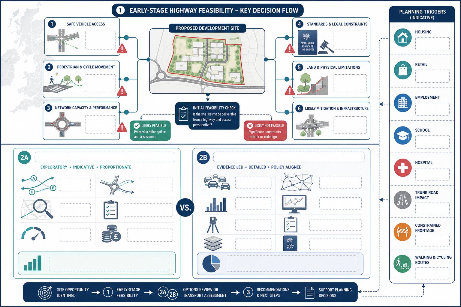
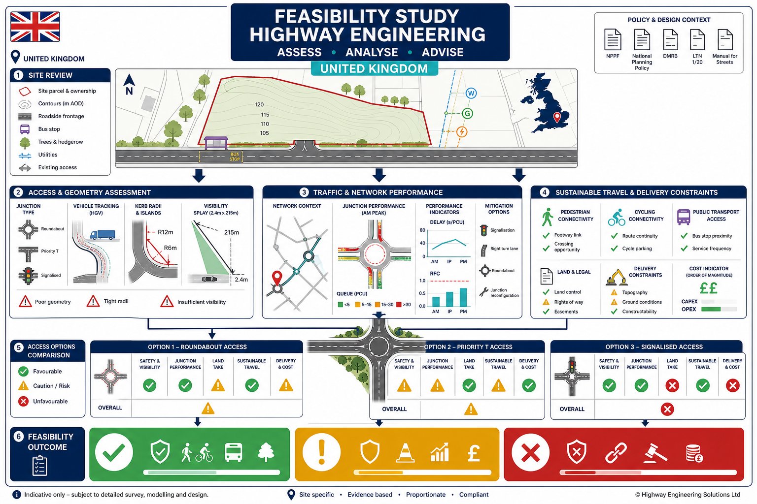
A highway engineering feasibility study is an early-stage appraisal of whether access and highway arrangements for a proposed development are capable of working in planning, engineering and delivery terms. Its job is not to polish a final design. Its job is to test realism.
In practice, we use it to answer a handful of critical questions early: can vehicles, pedestrians and cyclists get in and out safely: is the surrounding network likely to cope: are there obvious standards, land or legal barriers: and what level of mitigation may be needed before a scheme becomes acceptable? That is why it is commonly commissioned at pre-application stage, during land acquisition due diligence, for Local Plan promotion, or when an emerging layout still has options on the table.
For most project teams, the real value is speed and direction. A concise early review can prevent expensive redesign later, especially where sites sit on classified roads, near schools or hospitals, or rely on constrained frontage access. For developers and consultants weighing up scope, the role of Highway Engineering Consultants is often to identify that risk envelope before a planning application strategy hardens.
On complex sites, feasibility work also frames what comes next: whether a full TA, Road Safety Audit input, junction modelling or more detailed highway infrastructure design will be needed to support planning and delivery.
How Feasibility Differs From A Full Transport Assessment
A feasibility study is options-led and proportionate. It usually relies on indicative site layouts, broad development assumptions, observed site constraints and an outline view of likely traffic effects. It is there to test whether a concept is viable, not to present a complete evidential case for determination.
A full Transport Assessment is more formal, more data-heavy and more application-focused. It typically includes agreed scope, survey evidence, detailed trip generation, traffic distribution, assessment years, committed development review, capacity modelling and a fuller package of mitigation. It is the document used to support planning decisions against policy and authority requirements.
That distinction matters. If we ask a feasibility study to do the job of a TA, we usually waste time and money. If we ask a TA to rescue a weak concept that was never feasible, we create avoidable programme risk.
Typical Planning Triggers For A Feasibility Review
Certain triggers almost always justify a feasibility review. The obvious ones are major residential, employment, retail and mixed-use schemes, especially where access sits on a busy road or close to an existing junction. But smaller sites can need one too if the frontage is tight, visibility is compromised, gradients are awkward, or the surrounding street pattern is sensitive.
We also see early feasibility work commissioned where a site is being promoted through plan-making, where land value depends on proving a realistic access solution, or where local authority officers have already hinted that transport will be a sticking point. Trunk road interfaces, school-frontage activity, hospital access routes, collision history and protected routes for walking and cycling are all common triggers.
At that point, proportionate early input from Highway Design Consultants: How can de-risk the planning route by clarifying whether the issue is manageable, costly or fundamentally fatal.
Defining The Development Brief, Constraints, And Study Area
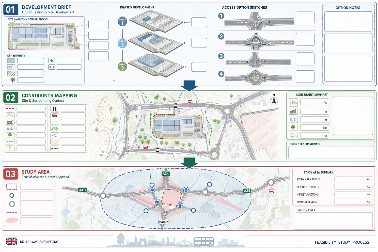
The quality of a feasibility study depends heavily on how well the brief is defined at the start. We need to know what is actually being tested: land use, scale, likely quantum, parking approach, servicing assumptions, phasing and intended access strategy. If those inputs are vague, the conclusions will be vague too.
We usually start by aligning the transport question with the development objective. A 20-unit residential scheme, a roadside trade counter and a logistics yard may sit on the same parcel of land, but they pose completely different demands in terms of trip profile, vehicle size, peak periods and junction form. Getting that right early prevents the team chasing the wrong solution.
The next step is constraints mapping. That means reviewing highway boundary, topography, structures, drainage features, retaining walls, trees, utilities, lighting columns, crossings, bus stops, rights of way, environmental designations and any need for third-party land. On many sites, the apparently simple access point is constrained by something mundane but decisive: a level difference, a telecom chamber, an adopted verge, or a visibility line that runs across someone else’s hedge.
The study area then needs to be sensible and proportionate. We define it around the likely zone of influence, key access points and junctions that may experience noticeable effects. Too narrow, and we miss the real constraint. Too wide, and the exercise turns into premature TA work. The aim is a defendable area that reflects the scale and likely transport consequences of the proposal.
Site Access, Visibility, And Junction Appraisal
This is usually where feasibility work becomes very concrete. But attractive a site looks on paper, planning success often turns on whether a safe, policy-compliant and practical access arrangement can be achieved.
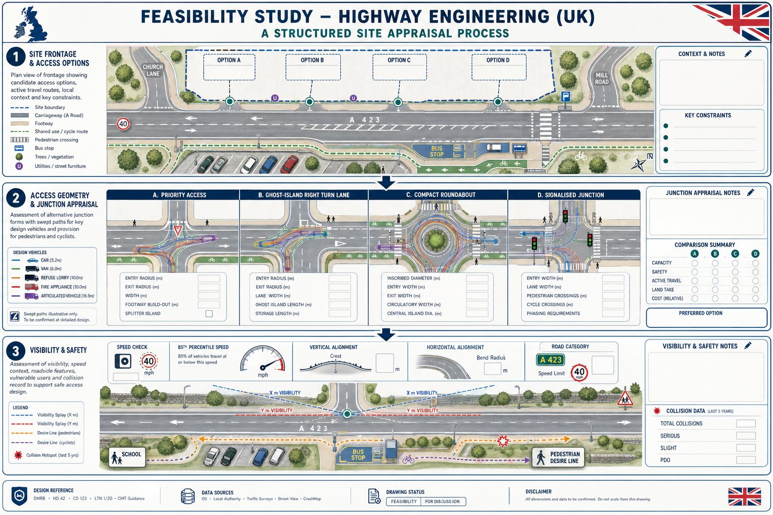
We start by identifying possible access locations for vehicles, pedestrians and cyclists, then testing how each one interacts with frontage activity, nearby junctions, crossings, bus stops, parking pressure and the wider street environment. The right access is not always the most obvious one. Sometimes a small shift in location avoids a tree, unlocks visibility, reduces conflict with a side road and removes the need for major utility diversions.
Junction form matters too. A simple priority access may work for one development quantum but not for another. In other cases, a ghost-island right-turn lane, compact roundabout or signalised solution becomes necessary. Early review of access design highway issues helps us check whether the land available, traffic environment and likely authority expectations line up with the proposed access strategy.
Where a scheme depends on a more involved node, input from Junction Design Consultants: How can be especially valuable in narrowing realistic options before the layout is fixed.
Access Geometry And Vehicle Tracking Requirements
An access that works for a car but fails for a refuse vehicle or fire appliance is not a workable access. So geometry comes first: carriageway width, kerb radii, swept paths, footway continuity, gradients, stopping areas, passing provision and internal turning space.
Vehicle tracking is one of the quickest ways to expose whether a concept is sound. We test representative vehicles for the actual use proposed: refuse wagons for housing, articulated deliveries for commercial schemes, emergency vehicles where required, and often vans because they are the everyday reality. This is especially important on tight urban frontage sites where walls, parking bays or street furniture squeeze the entry path.
A common mistake is assuming later detailed design can somehow solve inadequate width or turning. It usually cannot. If the geometry does not work at feasibility stage, the development quantum, access point or internal layout may need to change.
Visibility Splays, Speed Data, And Safety Considerations
Visibility is frequently the make-or-break issue. We review whether the required sightlines can be achieved in both directions, based on the character of the road, measured or reliable speed data and the applicable design approach. In 2026, authorities still expect a clear, evidence-led explanation where departures from standard assumptions are proposed.
That means looking beyond a drawing line. We consider vertical alignment, bends, vegetation, boundary walls, parked vehicles, street furniture and whether splays cross land outside the applicant’s control. Measured 85th percentile speeds are often essential, particularly where posted limits do not reflect real driver behaviour.
Safety review should also include collision history, proximity to schools or other vulnerable uses, pedestrian desire lines and the operational complexity of the frontage. A technically achievable access can still be a poor planning prospect if it introduces obvious conflict or depends on visibility that is difficult to maintain over time.
Traffic Conditions, Network Performance, And Future Demand
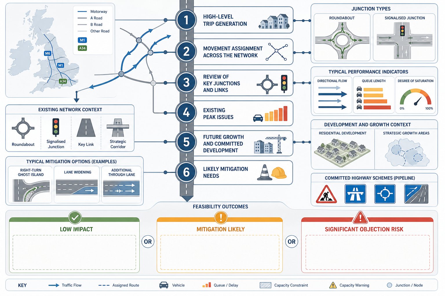
A feasibility study does not usually require the full analytical depth of a Transport Assessment, but it does need a credible view of traffic impact. Otherwise, the team is effectively making planning decisions blind.
We normally begin with high-level trip generation using an appropriate evidence base, then assign likely movements across the network to identify the junctions and links most likely to matter. The objective is not perfect forecasting at this stage: it is to understand whether the proposal is unlikely to create material issues, likely to need mitigation, or likely to face a significant objection.
Current conditions matter just as much as future demand. If a site access emerges onto a road already suffering from long peak queues, unreliable right turns or blocked junctions, even modest development traffic can become contentious. Equally, some apparently busy corridors continue to operate acceptably because flows are directional, junctions recover quickly or nearby alternatives exist.
We also need to account for committed development, local growth assumptions and any nearby highway changes already in the pipeline. For residential-led schemes, an early residential traffic impact review is often useful in judging whether the likely scale of off-site assessment will remain proportionate.
The key here is honesty. If a scheme is likely to require capacity improvements, signal staging changes, ghost-island provision, lane widening or demand management, a good feasibility study should say so clearly. Not because that kills projects, but because it allows land, cost and programme decisions to be made with open eyes.
Sustainable Travel, Active Travel, And Public Transport Connections
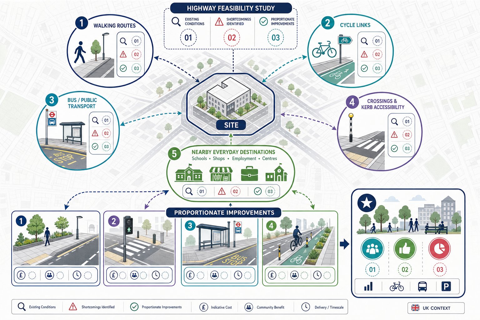
Highway feasibility in 2026 is not just about cars getting in and out. Planning success increasingly depends on whether a site can support sustainable travel patterns and connect well to surrounding places on foot, by cycle and by public transport.
So we audit existing walking routes, crossing points, footway widths, dropped kerbs, cycle facilities, bus stops, service frequency and the quality of links to everyday destinations such as schools, shops, centres and employment areas. A site may have a technically workable vehicular access yet still struggle in planning if active travel links are poor and no realistic improvements are identified.
This part of the review is often where better placemaking ideas emerge. A modest footway extension, a safer crossing location, a bus stop upgrade or a better cycle connection can materially improve a planning case and reduce pressure on highway objections. On public-facing schemes, that wider perspective also aligns with the more place-led expectations now seen across many authorities and in Public Sector Highway Engineering.
For commercial or mixed-use development, sustainable access is not a soft extra. It can influence parking levels, servicing strategy, mode share assumptions and eventually the acceptability of the whole proposal. A sound feasibility review should hence identify both current shortcomings and practical enhancements that could be delivered proportionately.
Land, Legal, And Deliverability Constraints That Affect Highway Options
Some highway options fail not because they are poor engineering, but because they are not deliverable in land or legal terms. This is where feasibility work earns its keep with lawyers, land teams and planning strategists.
We test whether the preferred access or junction arrangement sits wholly within adopted highway or land under the applicant’s control. If it does not, we need to understand exactly what third-party land is required, whether rights can realistically be secured, and what fallback options exist if they cannot. A sliver of verge, embankment or frontage garden can become a major issue if it is essential to visibility, widening or drainage.
Legal and procedural constraints also matter. Depending on the scheme, there may be implications for Section 278 or Section 38 agreements, stopping-up, rights of way diversion, highway dedication, private street works, adoption standards or, on larger infrastructure-led proposals, more formal order-making powers. These are not details to leave until after committee.
Deliverability also includes cost and buildability. Retaining structures, utility diversions, abnormal drainage works, bridge interfaces or extensive frontage reconstruction can make an option technically possible but commercially weak. For employment-led or roadside schemes, the difference between a neat in-boundary solution and one needing significant off-site works can be substantial, which is why early testing is especially important in Commercial Development Highway planning.
Drawing Up Feasible Highway Options And Comparing Them
A robust feasibility study should rarely stop at a single sketch. Where genuine choices exist, we need to draw up options and compare them in a structured way.
Usually that means preparing outline access or junction arrangements, defining likely highway works extents, and then testing each option against a consistent set of criteria: safety, capacity, active travel performance, land take, environmental effect, policy alignment, cost and deliverability. Sometimes one option is clearly better. More often, there is a trade-off. The safest junction may require the most land. The cheapest access may offer the weakest pedestrian environment. The option with the least engineering may create the greatest planning friction.
This comparative process helps project teams make decisions before they become expensive. It also gives planning officers and highway authorities confidence that alternatives have been considered rather than brushed aside. Where needed, we can then move from an option appraisal into more detailed design development with the right evidence base in place.
Importantly, comparison should be transparent. If an option is rejected because it depends on third-party land, fails swept-path testing, creates poor visibility or introduces severe network effects, that should be recorded plainly. Good feasibility work does not try to make every option look plausible: it narrows the field to what can actually be delivered.
Common Risks, Approval Issues, And How To Strengthen A Planning Submission
Most planning delays in highway matters are predictable. The same themes return again and again: inadequate visibility, over-optimistic access geometry, unresolved land requirements, weak traffic evidence, underplayed safety concerns and mitigation that appears late or feels disconnected from policy.
Another common problem is proportion. Some submissions overreach with a mountain of technical material before the basic feasibility questions are settled. Others undercook the issue, assuming a simple plan extract will be enough where the site is obviously constrained. Neither approach helps.
To strengthen a planning submission, we usually focus on five things. First, engage early with the highway authority on the real points of risk. Second, base the work on reliable surveys and site observations rather than assumptions. Third, present a clear option appraisal that shows why the chosen solution is the most credible. Fourth, align the proposal with local and national policy on safety, sustainability and placemaking. Fifth, be realistic about mitigation, including phasing if appropriate.
When projects move from feasibility to application support, a joined-up approach between planning, design and transport often matters more than producing a longer report. That is one reason experienced teams offering feasibility study highway engineering support tend to focus on concise evidence, local authority thresholds and deliverable recommendations rather than generic technical padding.
The strongest submissions make the authority’s job easier. They identify the issue, test it properly, explain the trade-offs and show a route to implementation.
Conclusion
A highway engineering feasibility study is most valuable when it is commissioned early enough to influence decisions, not just justify them. Done properly, it tells us whether a site can be accessed safely, whether the surrounding network and policy context are likely to support development, and where land, legal or design constraints may change the direction of the project.
For architects, planners, surveyors, developers and councils, that early clarity can save far more than report cost. It can protect programme, support land negotiations, shape a stronger masterplan and reduce the risk of planning objections appearing late in the process.
In 2026, the best feasibility work is balanced: technically sound, proportionate, policy-aware and realistic about delivery. If those ingredients are in place, the study becomes more than an early transport note. It becomes a decision tool that helps the whole team move forward with confidence.
Frequently Asked Questions About Feasibility Study Highway Engineering
What is a feasibility study in highway engineering and why is it important?
A feasibility study in highway engineering is an early-stage assessment that tests whether proposed access and highway arrangements for a development are safe, practical and likely acceptable to highway authorities. It helps identify risks early, avoiding costly redesign and delays later in planning.
How does a feasibility study differ from a full Transport Assessment?
A feasibility study is an options-led, high-level review using indicative layouts and outline traffic data to test concept viability. In contrast, a full Transport Assessment includes detailed surveys, modelling, and mitigation designs to support planning decisions formally.
When should a highway engineering feasibility study be commissioned?
Feasibility studies are typically needed during pre-application, land acquisition, Local Plan promotion, or when access arrangements are uncertain. They are crucial for major residential, retail, employment, or mixed-use schemes, especially if access is constrained or near sensitive sites like schools or hospitals.
What factors are considered for site access and visibility in a feasibility study?
Studies evaluate potential vehicle, pedestrian and cycle access points, access geometry, junction forms, visibility splays using measured speeds, obstructions, and safety concerns. This ensures the proposed access works comply with policy and are deliverable within site constraints.
Why is sustainable and active travel assessment part of highway feasibility studies in 2026?
Modern feasibility studies assess walking, cycling and public transport connections to support sustainable travel patterns. Improving active travel links can enhance planning outcomes, reduce highway objections, and align with public sector highway engineering expectations.
How do land and legal constraints impact highway feasibility options?
Delivery depends not only on engineering but also on control of necessary land, rights of way, and compliance with legal processes like Section 278/38 agreements. Identifying third-party land needs and procedural hurdles early helps avoid costly delays and unfeasible access solutions.