A masterplan can look convincing on paper and still unravel the moment transport is tested properly. We’ve seen it happen: a promising site advances through visioning, land budgets and sketch layouts, only for access constraints, junction pressure, bus routing or parking conflicts to force expensive redesign later. That is exactly why masterplan transport inputs matter.
In practical terms, masterplan transport inputs are the early transport evidence, assumptions and design parameters that shape a scheme before detailed layouts are locked in. They help us decide not only how people will move, but what can realistically be built, where it should sit, how dense it can be, when infrastructure is needed, and whether a planning application is likely to hold up under scrutiny.
For architects, planners, developers, surveyors, lawyers, builders and local authorities, the value is straightforward: better early inputs usually mean fewer surprises later. They support more credible land use plans, stronger design decisions, clearer conversations with highway authorities, and more robust planning submissions.
In 2026, that early-stage work matters even more. Policy pressure around sustainable transport, carbon reduction, healthy streets, accessibility and highway safety is sharper than it was a few years ago. So in this guide, we set out how we approach masterplan transport inputs in a way that is practical, policy-aware and geared towards deliverable outcomes.
What Masterplan Transport Inputs Are And Why They Matter Early
Masterplan transport inputs are the strategic transport assumptions and evidence base used to inform a site-wide concept before the design becomes too fixed. That includes access options, likely trip demand, movement corridors, sustainable travel potential, parking principles, servicing needs, and the relationship between the site and the wider network.
At this stage, we are not usually trying to produce final geometric design or a fully calibrated transport model. We are trying to answer more fundamental questions. Can the site support the proposed scale of development? Where should the principal access points be? What sort of street hierarchy is sensible? How much can we rely on walking, cycling and public transport? Which junctions are likely to become pressure points? And what mitigation may be needed later?
Those early answers shape the whole masterplan. If they are weak, optimistic without evidence, or left too late, the scheme often carries hidden risk all the way into application stage. That is when teams discover that a preferred access cannot be delivered, a bus route cannot turn, parking is out of step with policy, or a key junction needs upgrades the scheme has not budgeted for.
That is why early alignment between land use planning and transport planning matters. A robust transport assessment for developments rarely starts at the application boundary line: it starts when the masterplan is still flexible enough to improve.
How Transport Inputs Shape Land Use, Density And Site Layout
Transport is not a technical appendix to be bolted on after the “real” planning work is done. It is one of the forces that determines the land use pattern itself.
Street hierarchy, access points and public transport corridors influence block structure, frontage conditions, plot depth and parcel efficiency. Put simply, where movement goes, development tends to organise around it. A site with strong public transport frontage and direct active travel links may support higher density homes, smaller parking ratios, or a mixed-use centre in a location that encourages footfall. A site with a constrained single access and poor non-car connectivity may need a different density profile altogether.
We also use transport inputs to understand desire lines. Where are people likely to walk to school, a local centre, open space, healthcare, employment areas or a station? If those routes are indirect, severed or unpleasant, car dependency rises quickly. If they are direct and legible, the masterplan can support healthier and more sustainable travel habits from day one.
This is especially important on larger or phased schemes, where the movement framework can either support placemaking or quietly undermine it. On more complex projects, a mixed use masterplan approach helps coordinate access, land use intensity and parking strategy rather than treating them as separate design problems.
Good transport inputs do not reduce design ambition. Usually, they make it more credible.
Key Planning And Policy Drivers That Influence Transport Strategy
By 2026, transport strategy is shaped as much by policy as by engineering. National planning policy across England continues to push developments towards sustainable travel patterns, safe and suitable access, and location-efficient growth. But the real detail often sits at local level.
Local Plans, transport strategies, parking standards, area action plans, town centre frameworks and active travel policies all influence what is likely to be acceptable. Some authorities set explicit mode share targets. Others place heavy emphasis on reducing private car reliance, protecting bus corridors, or improving cycling connectivity. In urban authorities, parking restraint may be a central issue. In more rural authorities, the focus may be on safe access, realistic mitigation and avoiding isolated car-led layouts.
Then there are wider duties and objectives: net zero, air quality management, road safety, equalities, inclusive design and public health. These are no longer side considerations. They often affect officer recommendations and committee discussions directly. A scheme that appears to increase car dependency without a convincing justification can face resistance even if its junction modelling is technically acceptable.
That is why we try to ground transport strategy in policy from the start, not retrofit policy wording later. An Access Strategy Transport approach tied to the Local Plan and local highway expectations usually produces stronger design choices and cleaner planning narratives. And where carbon reduction is a live issue, Net Zero Transport Planning principles can materially influence mode share assumptions, parking levels and infrastructure triggers.
Core Baseline Information Needed Before Design Work Progresses
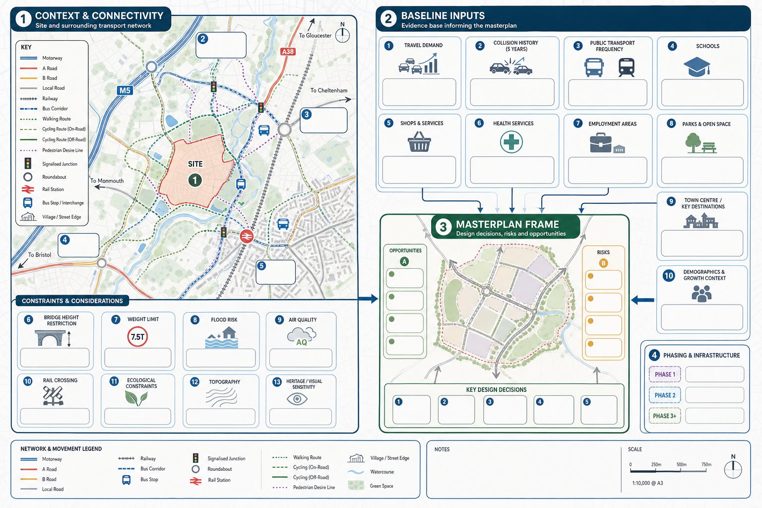
Before a masterplan starts hardening into preferred options, we need a baseline that is broad enough to reveal constraints and specific enough to guide decisions. Too many projects jump from site red line to concept layout without this step, and that is usually where avoidable risk begins.
At minimum, we need to understand the highway network, key junction performance, collision history, public transport availability, walking and cycling links, parking controls, committed development, and any planned infrastructure schemes that could affect demand or capacity. We also need to know how the authority is likely to scope the transport evidence later.
This is not just data gathering for its own sake. Baseline work tells us what kind of development pattern is realistic. It also shows where we can unlock opportunities. A nearby bus corridor, a new walking link, or a planned junction upgrade can change the picture significantly.
For developers and planning teams working to tight programmes, this is where experienced Transport Planning Consultants: often add value quickly: turning a mass of local transport context into a usable set of design parameters, risks and next steps.
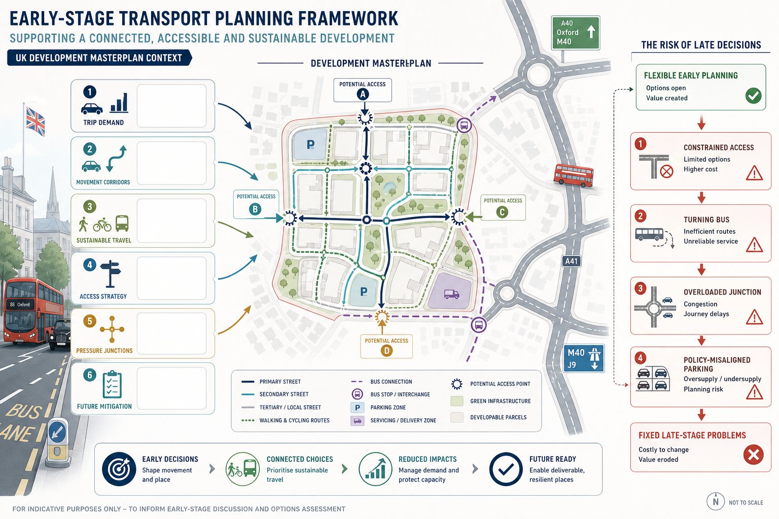
Site Context, Access Constraints And Surrounding Network Conditions
The first layer is the site’s position within the wider transport network. Is it fronting a strategic road, a local distributor, or a constrained village street? Are there weight limits, height restrictions, bridge constraints, rail crossings, flood zones, air quality issues or ecological designations affecting access choices? Is the surrounding street pattern porous or highly limited?
These factors matter early because they can eliminate options. A beautifully drawn boulevard is not much use if the external connection cannot physically or safely support it. The same goes for assumptions about construction access, bus penetration or servicing routes.
We also review nearby junctions and corridors that are likely to carry site traffic. Even at masterplan stage, it is usually possible to identify likely stress points. If a roundabout already struggles in the AM peak, or if a signal junction has limited reserve capacity, that needs to inform layout, land use intensity and phasing assumptions.
And there is a practical point here: authorities tend to respond better when the team acknowledges obvious surrounding constraints early rather than pretending they do not exist.
Existing Travel Demand, Local Facilities And Sustainable Travel Opportunities
The second layer is how people already travel in and around the area, and what destinations are realistically available without a car. Census data, local surveys, mobile data where appropriate, school travel patterns, bus service frequency, rail access and known peak periods all help build a picture.
We then map nearby facilities: schools, food stores, health services, employment clusters, parks, community uses and town centres. This reveals two things. First, which external trips might realistically be made on foot, by cycle or by public transport. Second, which missing facilities could sensibly be brought into the site to reduce off-site travel demand.
This is where transport planning becomes genuinely strategic. If a masterplan places a local centre or primary school in the wrong location, people may drive short distances they could have walked. If it sits on the natural desire line, mode share can shift more credibly.
For larger schemes, that analysis often overlaps with Private Sector Transport Planning decisions about viability, phasing and infrastructure timing.
Trip Generation, Distribution And Assignment At Masterplan Stage
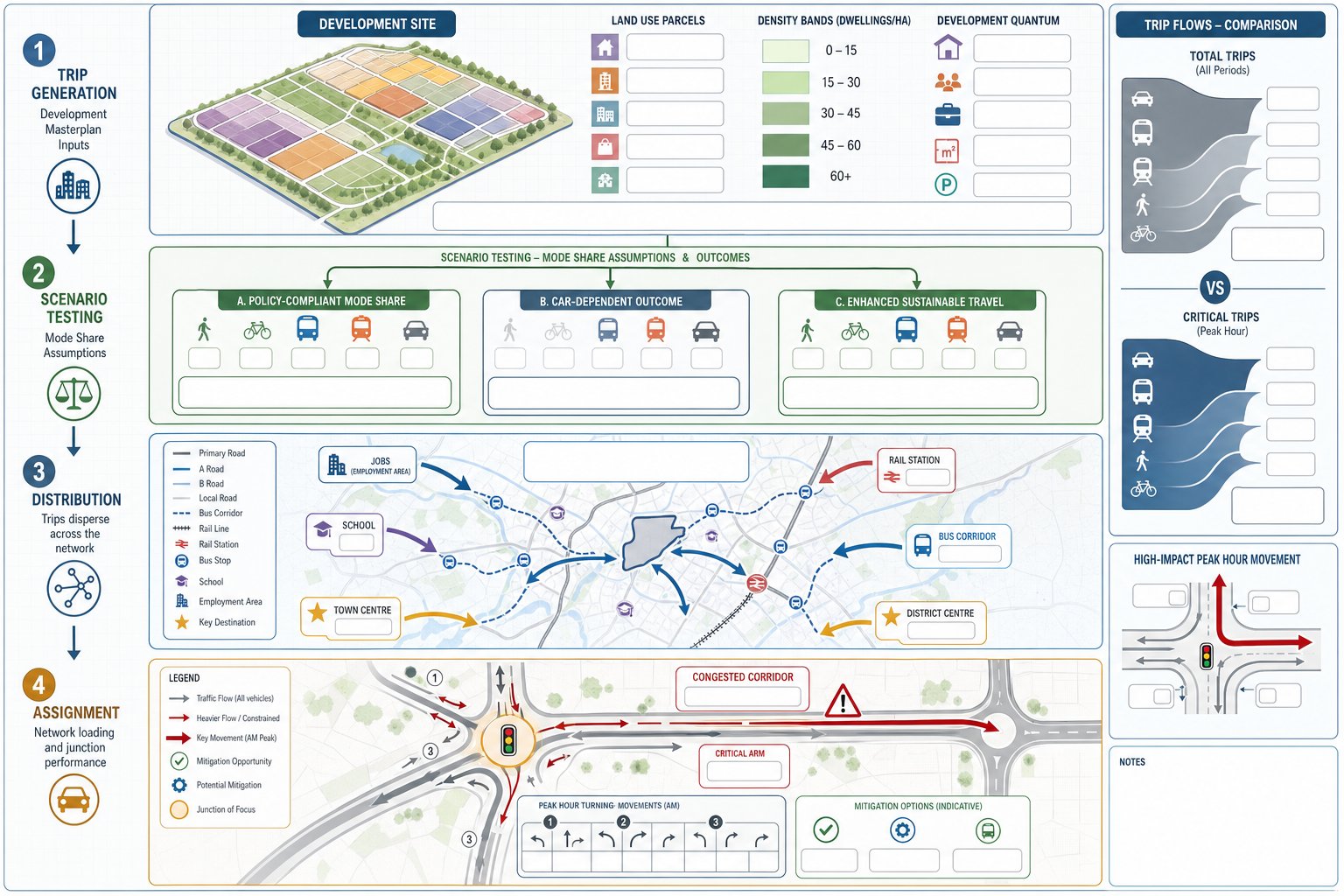
Trip generation at masterplan stage is necessarily high level, but it still needs discipline. We usually begin with land use assumptions, density ranges and likely development quantum, then test a sensible range of trip rates rather than a single optimistic point estimate.
The key is not just how many trips the site may produce, but under what travel behaviour assumptions. A scheme next to frequent bus services, local jobs and schools should not be assessed in exactly the same way as an edge-of-settlement site with limited alternatives to the car. Scenario testing is essential: policy-compliant mode share, more car-dependent outcomes, and sometimes an enhanced sustainable travel case if infrastructure is delivered.
Distribution and assignment then show where those trips are likely to go and which parts of the network carry them. At this stage, we are trying to flag likely issues, not claim false precision. If the broad pattern suggests pressure on one arm of a junction or on a corridor with existing congestion, that informs design choices and infrastructure planning straight away.
A good masterplan-stage exercise also distinguishes between total trips and critical trips. Not every movement affects planning risk equally. Often, a small number of peak-hour turning movements at a sensitive junction drive the need for mitigation far more than the total daily traffic figure.
Designing Movement Networks For All Modes Across The Site
A strong site-wide movement network does two jobs at once: it enables efficient access, and it creates a place people can actually live, work and move around comfortably. The best masterplans do not separate those aims.
We normally start with a clear hierarchy of primary streets, secondary streets and more local routes, each with an intended place and movement function. That sounds obvious, but many weak layouts are really just undifferentiated road patterns trying to solve every problem at once. The result is often poor legibility, indirect walking routes, awkward service access and vehicle speeds that feel too high for the setting.
At masterplan stage, we want the structure to be permeable for people but controlled enough for vehicles. That means direct walking and cycling links, logical street connections, public transport routes that can operate sensibly, and vehicle access points that do not dominate the whole plan. It also means designing with future details in mind: refuse vehicles, emergency access, parking courts, frontage quality, crossing points and likely tracking needs.
Where schemes involve multiple stakeholders or public scrutiny, early public consultation transport can be useful. It often exposes desire lines, school-run pressures and local rat-running concerns that desktop work alone may miss.
Walking, Cycling And Public Transport Integration
Walking, cycling and public transport integration should be embedded in the plan structure, not added as green lines on a later diagram. Routes need to be direct, safe, attractive and connected to actual destinations people care about.
That means looking beyond the site boundary. Can residents walk to existing centres without negotiating hostile junctions? Does the cycle network connect to schools and employment, or stop abruptly at the edge of the site? Are bus stops placed within realistic walking catchments, with routes that operators can serve efficiently? On larger sites, is there land safeguarded for bus priority or future transit if growth justifies it?
The quality of these decisions has a direct effect on mode share credibility. Authorities are understandably sceptical of low-car strategies where the active travel offer is indirect or tokenistic. But when routes are legible, overlooked, and aligned with desire lines, sustainable travel assumptions are far easier to defend.
Vehicle Access, Servicing, Emergency Access And Parking Strategy
Vehicle movement still matters, of course. But sustainable the ambition, a masterplan has to work for general access, deliveries, refuse, maintenance and blue-light response.
Early questions include how many vehicular access points are needed, whether they should be all-movements or limited-turn, how emergency access resilience is provided, and whether service routes conflict with schools, squares or primary pedestrian streets. For employment or mixed-use sites, servicing can drive a surprising amount of geometry and land take.
Parking strategy is another area where early clarity pays off. The issue is not only quantum, but location, type, management and how parking supports the overall movement strategy. Too much parking can undermine mode share and urban design. Too little, or badly arranged parking, can trigger operational problems and objection. Good strategy is policy-led, market-aware and explicit about how visitor, accessible, cycle, residential and servicing needs are handled.
On schemes moving towards application, that logic should align with the wider masterplan transport inputs evidence base so the parking narrative is not detached from the rest of the transport case.
Testing Development Scenarios, Phasing And Junction Impacts
One of the most useful things we can do at masterplan stage is test alternative futures before anyone becomes too attached to a single one. Different land use mixes, density assumptions, access arrangements and mode shares can produce very different impacts on the network.
Scenario testing helps us answer practical questions. If residential density increases near a transport corridor, does that strengthen sustainable travel outcomes or overload a key junction? If a local centre is brought forward in phase one, can it internalise more trips early? If a secondary access is delayed, what does that do to resilience and emergency planning? These are not academic exercises. They affect viability, infrastructure timing and the credibility of the planning strategy.
Phasing is particularly important on larger sites. A layout may work perfectly at completion and still struggle badly in its early phases if bus penetration, pedestrian links or junction improvements arrive too late. We hence look for trigger points: what infrastructure is needed by occupation thresholds, what can be reserved for later, and what must be secured from the outset.
This is also where transparent assumptions matter. Highway authorities are far more likely to engage constructively when they can see how the scenarios were built, what is fixed, what is flexible, and where sensitivity testing has been applied. Overconfident black-box forecasts rarely help.
Common Risks That Delay Planning Applications And How To Avoid Them
Most transport-related planning delays are not caused by obscure technical issues. They usually come from a handful of predictable mistakes.
The first is underestimating demand. Teams sometimes lean too heavily on idealised mode share assumptions without demonstrating how the site layout, local context and transport interventions will support them. That tends to unravel when junction testing or officer review begins.
The second is policy misalignment. Excessive parking, weak walking and cycling provision, inaccessible bus stop locations, or layouts that prioritise vehicle flow over place can all trigger redesign. Even if those issues are fixable, they absorb time and weaken confidence in the scheme.
The third is late engagement. If the local highway authority, public transport operators, landowners with access interests, or internal planning officers are only brought in once the preferred layout is effectively fixed, objections harden quickly. In our experience, many of the best outcomes come from early, concise technical dialogue rather than long defensive exchanges later.
The fourth is treating transport as a standalone report rather than a thread running through the masterplan. Access, density, parking, viability, phasing and public realm all interact.
The way to avoid these risks is fairly simple, though not always easy: establish a robust baseline early, be realistic about uncertainty, test scenarios openly, align with policy, and keep the transport strategy integrated with design decisions. With a team used to preparing concise planning-ready evidence quickly, those steps are much easier to manage under real project timelines.
Conclusion
Masterplan transport inputs are not paperwork to justify a finished idea. They are part of how the right idea is formed in the first place.
When we get them right early, they shape land use more intelligently, reduce redesign, support better engagement with authorities, and produce planning applications that are simply stronger. They help us understand what a site can carry, where movement should sit, which infrastructure matters most, and how policy expectations can be met without wishful thinking.
For architects, planners, developers and councils alike, the practical lesson is clear: transport should be in the room while the masterplan is still flexible. That is when evidence is most useful and when risk is cheapest to remove.
In 2026, with tighter scrutiny on sustainability, safety, accessibility and deliverability, that early discipline is not optional. It is often the difference between a scheme that keeps momentum and one that spends months undoing avoidable decisions.
Frequently Asked Questions about Masterplan Transport Inputs
What are masterplan transport inputs and why are they important early in the planning process?
Masterplan transport inputs are the early transport evidence, assumptions, and design parameters that shape a site-wide masterplan before detailed layouts are finalised. They are crucial early on because they reduce risks, avoid costly redesign, and support robust, policy-aligned planning applications.
How do transport inputs influence land use and site density in masterplanning?
Transport inputs shape street hierarchy, access points, and public transport corridors, which affect block structure and plot efficiency. They help position local centres or schools along active travel routes, encouraging sustainable travel and enabling higher density development where appropriate.
Which core baseline information is needed before progressing with masterplan transport design?
A robust baseline includes the existing highway network, junction performance, safety history, public transport availability, walking and cycling links, committed developments, and planned infrastructure. This ensures realistic and deliverable design options that align with local policies.
How can transport inputs support achieving sustainability and policy goals in 2026 developments?
Embedding transport strategy early aligns with national and local policies on sustainable travel, carbon reduction, and accessibility. Integrating walking, cycling, public transport routes, and parking strategies supports mode share targets and strengthens planning outcomes under stricter policy scrutiny.
What role does scenario testing play in masterplan transport inputs?
Scenario testing evaluates different land use mixes, densities, and travel behaviour assumptions to identify network pressures and infrastructure needs early. This informed approach helps phase development realistically and prevents costly delays due to underestimated demand or policy misalignment.
How should vehicle access and parking strategy be considered within masterplan transport inputs?
Vehicle access points, servicing routes, emergency access, and parking location and quantity must align with overall movement strategy and policy. Well-planned parking supports sustainable travel goals without compromising operational needs or urban design quality.