A transport assessment for developments can look deceptively simple from the outside. Count some trips, review a few junctions, write up the findings, done. In practice, it rarely works like that. By 2026, planning teams are dealing with tighter scrutiny on cumulative impact, stronger expectations around active travel, local authority threshold variations, and a much lower tolerance for vague assumptions.
We see this all the time: a scheme is broadly acceptable in planning terms, but the application slows down because the transport evidence was scoped too late, the wrong survey period was used, or the local highway authority wanted a fuller assessment than the team anticipated. None of those issues are dramatic on their own. Together, though, they can add weeks or months.
That is why a good transport assessment for developments is not just a technical document. It is a planning tool. It helps us explain how a site will function, whether impacts are likely to be significant, and what mitigation or sustainable travel measures are needed to make the proposal work in the real world.
In this guide, we set out what planning teams need to get right: when a transport assessment is required, how local planning authorities make that decision, what the document should contain, which evidence matters most, and where applications commonly run into trouble. If the aim is to keep planning moving, the transport strategy has to be credible from day one.
What A Transport Assessment Is And When It Is Required
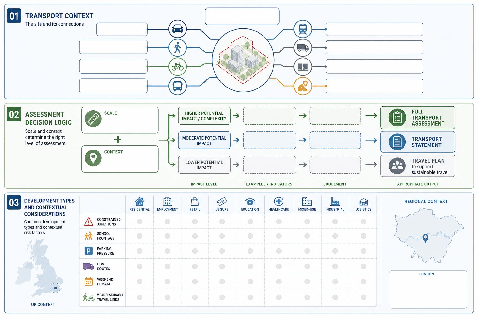
A Transport Assessment, usually shortened to TA, is a structured assessment of how a proposed development will affect the transport network across all relevant modes. That means not only private car traffic, but also walking, cycling, bus, rail, servicing, loading, road safety, and in some cases construction traffic. The core question is straightforward: will the development create significant movement, and if so, what needs to be done about it?
In UK planning practice, a TA is generally required where a scheme is likely to generate material travel demand or where the surrounding network is sensitive enough that even moderate growth could become an issue. National policy points planning teams toward the test of whether impacts would be severe, but that does not mean authorities wait for obvious failure before asking for evidence. Quite the opposite. Most councils and highway authorities want the assessment early enough to understand whether impacts can be managed through design, mitigation, or travel planning.
For applicants, the practical point is this: the need for a transport assessment for developments is driven by both scale and context. A medium-sized scheme on a constrained urban site can trigger more transport work than a larger one in a robust location. And where teams want broader support on risk, phasing and evidence, good Private Sector Transport Planning often makes the difference between a smooth submission and a difficult one.
How A Transport Assessment Differs From A Transport Statement And A Travel Plan
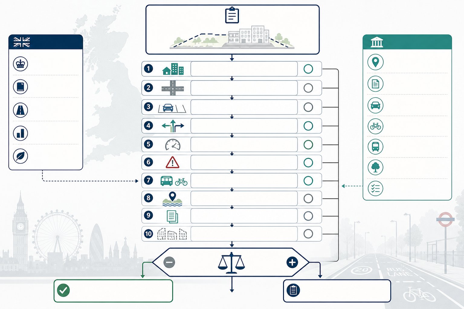
A TA is the most comprehensive of the three common transport documents submitted with planning applications.
A Transport Statement is a lighter-touch document. It is usually suitable where impacts are expected to be limited, the proposal is relatively modest, and detailed junction modelling or extensive network analysis is unlikely to be necessary. A statement still needs to be evidence-based, but it is narrower in scope.
A Travel Plan, by contrast, is not a substitute for a TA. It is a management strategy. It sets out measures, targets and monitoring arrangements to encourage sustainable travel and reduce reliance on the private car once the development is occupied. Cycle parking, welcome packs, car club membership, public transport information, staff travel coordinators, school travel initiatives – these sit more naturally in a Travel Plan.
The three documents often work together. A full TA may establish the likely transport effects, a TS may be enough for smaller schemes, and a Travel Plan may be secured alongside either. The mistake we sometimes see is trying to use one document to do another job.
Which Types Of Development Usually Need One
Major residential schemes commonly need a TA, especially where unit numbers rise beyond local thresholds or where access is proposed onto a stressed network. The same is true for large employment, retail, leisure, education, healthcare and mixed-use developments. In London, strategic or referable schemes are especially likely to trigger transport scrutiny.
But there is no universal national threshold that settles every case. Local guidance matters. So does the character of the site. A smaller development can still require a TA if it sits near a constrained junction, on a corridor with safety concerns, close to a school, or in an area with weak sustainable travel links.
Industrial and logistics schemes may need one because of HGV effects rather than headline trip totals. Town-centre retail schemes may need one because of parking pressure, servicing and weekend patterns. In that sense, transport assessment for developments is less about the use class label and more about the movement profile the proposal will generate.
How Local Planning Authorities Decide Whether A Transport Assessment Is Needed
Local planning authorities do not decide the need for a TA in a vacuum. They do it in consultation with the local highway authority, and often against a combination of national policy, local validation requirements, supplementary guidance, and site-specific judgement. The result is rarely mechanical.
What planning teams should expect is an evidence-led but pragmatic test. Authorities will look at the proposed use, scale, access arrangement, parking provision, likely trip rates, local network performance, collision history, sustainable travel opportunities and whether nearby committed development could push the system further. If there is a realistic prospect of significant impact, they will usually want a TA rather than a lighter statement.
That is one reason specialist input matters early. A team with experience of local authority expectations can sense when a site that looks borderline on paper is likely to attract a fuller transport request. That is also where Transport Planning Consultants: can help frame a sensible scoping discussion before the design hardens too far.
National And Local Policy Context That Shapes The Requirement
At national level, the main frame comes from the National Planning Policy Framework. It promotes sustainable transport, requires safe and suitable access for all users, and sets the familiar test that development should only be refused on highways grounds if the residual cumulative impacts are severe. That wording matters, but it does not remove the need for robust analysis. If anything, it raises the standard of evidence because everyone is arguing over what “severe” means in context.
Older Department for Transport guidance on transport assessments still influences practice, even where it is not the newest document on the shelf. Then local policy layers on top: local plans, parking standards, design guides, active travel policies, area action plans, and supplementary planning documents. TfL and London boroughs, for example, often have their own established expectations.
The practical lesson is simple. Planning teams should not assume one council’s threshold or format will satisfy another. Local interpretation is part of the requirement.
Thresholds, Site Sensitivity, And Cumulative Impact Considerations
Thresholds are often the starting point, not the finish line. Councils may publish indicative levels based on dwelling numbers, floorspace, or parking provision, but these are usually guidance rather than absolutes. A proposal below threshold can still need a TA. A proposal above threshold may, occasionally, be scoped proportionately.
Site sensitivity often tips the balance. A location beside a congested roundabout, near a substandard access, on a corridor with recent collisions, or with poor bus service and weak pedestrian links will draw more scrutiny. Equally, a highly accessible town-centre site may face detailed questions about servicing, kerbside activity and pedestrian movement rather than classic highway capacity.
Cumulative impact is the other big factor in 2026. Authorities increasingly expect applicants to account for committed development, background growth and interaction with nearby schemes. A development that seems acceptable in isolation may not look the same when three other consented sites are added into the forecast. And if the site has unusual access constraints, a focused Access Strategy Transport approach can save a lot of later rework.
What A Transport Assessment Typically Includes
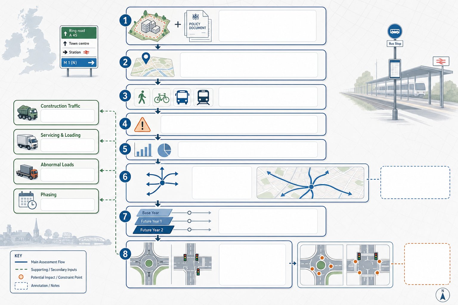
A sound TA tells a coherent story. It describes the proposal, explains the policy and transport context, establishes the existing baseline, forecasts future movement, tests likely impacts, and sets out mitigation where needed. The exact shape varies by site, but most good documents follow that broad sequence.
At minimum, we would expect a clear development description, relevant planning and transport policy review, site location analysis, baseline transport conditions, sustainable travel audit, road safety review, trip generation, trip distribution and assignment, future year scenarios, and impact testing at the junctions or network links where material change is anticipated. If construction traffic, servicing, abnormal loads or phasing are important, those need to be addressed too.
The strongest assessments are proportionate. They do enough technical work to answer the right questions, but they do not bury the reader under unnecessary modelling. Increasingly, teams also align the TA with related documents such as framework travel plans, delivery and servicing plans, and wider Property Development Transport advice so the planning case feels joined up rather than piecemeal.
Site Access, Highway Conditions, And Sustainable Travel Review
This part of the TA explains how the site works today and how it could work once developed. It typically covers the existing and proposed access arrangements, visibility splays, junction form, carriageway width, footways, crossing opportunities, cycle connections, bus stops, rail access where relevant, parking controls and loading conditions.
A good sustainable travel review is not a token map with a few circles drawn around the site. It needs to show the quality of routes, not just their existence. Is the walk to the bus stop attractive and step-free? Is there a safe crossing on the desire line? Are cycling links coherent or do they disappear at the first busy junction? These details affect modal choice in practice.
Road safety also matters here. Personal Injury Collision data, usually for the most recent five-year period, helps identify patterns that may influence access design or mitigation. If there is an existing safety concern, ignoring it almost guarantees questions from the highway authority.
Trip Generation, Distribution, Assignment, And Junction Impact Analysis
This is where the TA moves from description to forecast. Trip generation estimates how many journeys the development is likely to produce by mode and by time period, often using TRICS and comparable sites, adjusted where needed for local conditions. Depending on the use, allowances may be made for pass-by, diverted trips, internal capture or existing lawful use netting.
Distribution and assignment then show where those trips are likely to come from and go to, and which routes or junctions they will affect. This needs to be realistic, defensible and ideally agreed at scoping stage. Overly optimistic routing assumptions are easy to spot.
Impact analysis usually compares base and future year scenarios, with and without the development, including committed schemes and growth. Junction capacity modelling may be needed where traffic changes materially – often around the sort of +30 two-way peak hour trip change that prompts closer scrutiny, though local practice varies. For larger schemes, the transport evidence may sit alongside a broader traffic impact assessment to ensure the network effects are explained consistently.
The Data, Surveys, And Evidence Needed To Support The Assessment
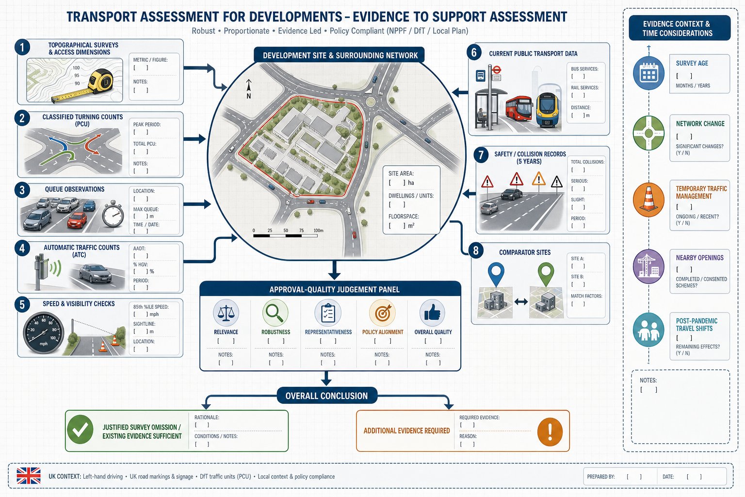
The quality of a TA is only as good as the evidence beneath it. Weak data does not always fail immediately, but it tends to surface during consultation, and by then the programme damage is done.
Typical evidence includes topographical surveys, access measurements, classified turning counts at key junctions, queue length observations, automatic traffic counts, and speed surveys where visibility or road character are important. Public transport information should be current and specific, not copied from an old report. Collision data normally covers a five-year period and needs proper interpretation rather than just a plotted plan.
Trip generation evidence also deserves care. Comparable sites should be genuinely comparable in scale, location and operating characteristics. Planners and lawyers can usually spot when a suburban edge-of-town comparator is being used to defend a highly accessible urban proposal, or vice versa.
Timing matters as well. Survey data can age quickly if network conditions change, temporary traffic management was in place, nearby development has opened, or post-pandemic travel patterns have shifted materially in the area. The most robust approach is to confirm survey needs early, document them in a scoping note, and test assumptions before design decisions become expensive to unwind.
For schemes with more complex approval paths, teams often benefit from input similar to that provided by Developer Transport Consultants: who understand how evidence standards vary between authorities.
There is also a judgement point. Not every site needs every survey. But every survey that is omitted should be omitted for a reason that the authority is likely to accept.
Common Problems That Delay Planning Applications
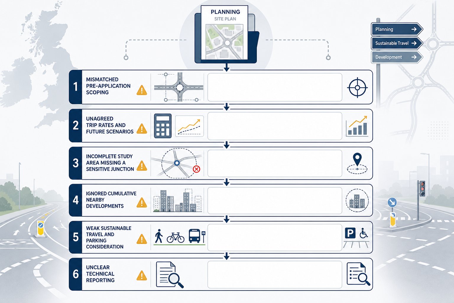
Most transport delays are avoidable. They do not usually arise because a site is impossible to develop: they arise because the application team and authority are working from different assumptions.
One common problem is inadequate pre-application scoping. If the applicant assumes a Transport Statement will do and the highway authority expects a full TA with junction modelling, the disagreement lands late and hard. Another is relying on unagreed trip rates, growth factors or future year scenarios. Even where the numbers are technically arguable, lack of prior agreement can trigger a second round of work.
Study areas are another repeat issue. If a key junction is omitted because it falls just outside a neat radius, but local officers know it is sensitive, the assessment will come back for expansion. The same applies when cumulative development is underplayed or when nearby consented schemes are ignored because they are inconvenient.
Poor coverage of sustainable travel opportunities also slows applications. Authorities increasingly expect serious consideration of walking, cycling and public transport, plus mitigation that goes beyond “there is a bus stop nearby”. Parking strategy can become a pinch point too, especially where overspill risk, servicing conflict or disabled access has not been thought through: in those cases a firmer Parking Strategy For framework is often needed.
Finally, some reports simply do not read well. Technical quality matters, but so does clarity. If the authority cannot follow the logic, it will ask more questions. And that is where deadlines start slipping.
How To Scope The Assessment Properly At An Early Stage
Good scoping is the cheapest time-saving measure in the whole process. Before surveys are commissioned or drawings fixed, the applicant team should engage with the local planning authority and local highway authority to agree, as far as possible, what level of assessment is needed.
A short scoping note can cover the essentials: whether a TA, TS and/or Travel Plan is expected: the development quantum: existing lawful use assumptions: survey dates and locations: study area: committed developments: growth factors: forecast years: and the modelling tools proposed. It does not need to be ornate. It does need to be precise.
This stage is also where awkward issues should be surfaced rather than hidden. If the site sits near a constrained school corridor, accesses a strategic road, or may require swept path work for servicing, it is better to identify that now. The same goes for phased development and interim arrangements.
In our experience, early scoping works best when transport input is integrated with architecture, planning and legal strategy rather than treated as a separate afterthought. That is broadly how experienced teams at Traffic Engineer In and similar practices keep planning submissions focused on what the authority actually needs.
A final practical point: record the agreed scope. Meeting notes, email confirmation or a simple agreed note can be invaluable six weeks later when personnel change and memories become selective.
Transport Assessments For Different Development Types
A TA should always be tailored to the movement characteristics of the scheme. The structure may be familiar, but the emphasis changes a lot by use type.
Residential development usually turns on peak-hour commuting, school travel, parking demand, access to local centres, and the realism of walking, cycling and bus options. For suburban sites, the quality of off-site pedestrian links often matters more than applicants first assume.
Retail and leisure schemes need a different lens. Weekend and inter-peak demand can be more important than weekday AM peaks. Parking accumulation, servicing, taxis, pick-up activity and interaction with the town centre all come into play.
Employment and office schemes often focus on commuter patterns, public transport accessibility, shift changes and car-park management. Where flexible or hybrid working assumptions are used, they should be handled carefully and evidenced, not waved through as convenient trend language.
Education schemes have very distinctive peak patterns. Parent drop-off, coach access, pupil catchments, school street arrangements and road safety at the gate line are often central. A technically small increase in trips can still feel severe at exactly the wrong 20 minutes of the day.
Healthcare development tends to spread demand over longer periods, with separate profiles for staff, visitors, outpatients and emergency access. And industrial or logistics schemes often hinge on HGV routing, yard operation, turning geometry and impacts on strategic roads rather than headline daily traffic alone.
Across all of these, transport assessment for developments works best when it reflects how people and vehicles will actually use the place – not how we wish they might on a spreadsheet.
Frequently Asked Questions about Transport Assessment for Developments
What is a transport assessment for developments and when is it required?
A transport assessment for developments (TA) is a comprehensive study evaluating how a proposed development affects all transport modes. It is required when a development is expected to generate significant movements or could cause severe transport impacts, assessed by scale, location, and network sensitivity.
How does a transport assessment differ from a transport statement and a travel plan?
A transport assessment is a full, multi-modal impact study for larger or sensitive developments. A transport statement is a lighter document for proposals with limited impact. A travel plan is a strategy to manage travel behaviour post-occupation, promoting sustainable travel and reducing car use.
What factors do local planning authorities consider when deciding if a transport assessment is needed?
Local planning authorities consider national policies, local thresholds, site sensitivity such as congested junctions or safety issues, cumulative impacts with other developments, and sustainable travel opportunities, usually consulting with highway authorities to judge the need for a TA.
What are common causes of delays in planning applications related to transport assessments?
Delays often arise from inadequate pre-application scoping, using unagreed trip rates or scenarios, omitting key junctions in study areas, poor sustainable travel coverage, missing survey data, ignoring safety or cumulative impacts, and unclear reporting that confuses authorities.
How can developers ensure their transport assessment meets local authority expectations early in the planning process?
Early engagement with local highway and planning authorities to agree scope, surveys, modelling approaches, study areas, and assumptions is critical. Documenting these agreements in a scoping note or meeting records reduces risk and aligns the TA with authority needs.
What typical content is included in a transport assessment for developments?
A typical TA includes a description of the development, policy reviews, existing transport conditions, sustainable travel audit, road safety analysis, trip generation and distribution forecasts, junction impact assessments, construction traffic considerations, and mitigation strategies including travel planning.