Richmond is one of those boroughs where transport planning rarely stays simple for long. A scheme can look straightforward on a drawing pack, then quickly run into real-world questions about school traffic, parking stress, constrained town-centre roads, bus reliability, walking routes, or whether a servicing vehicle can actually turn without blocking everything behind it. That’s where a traffic engineer in Richmond becomes central to the planning process.
For architects, planners, developers, surveyors and legal teams, the transport chapter of an application often carries more weight than expected. It’s not just about forecasting vehicle trips. It’s about proving that a development can be safely accessed, that its impact on the local highway network is acceptable, and that it supports sustainable travel in a way that aligns with Richmond, London-wide policy, and practical highway standards.
In our experience, the strongest applications are not the ones with the longest reports. They’re the ones that scope the right issues early, use proportionate evidence, and address local concerns before they become objections. In Richmond, that usually means thinking carefully about junction operation, parking, servicing, pedestrian conditions, cycle provision and public transport accessibility from the outset.
This guide explains what a traffic engineer in Richmond actually does, when that input is needed, how Transport Statements and Transport Assessments are prepared, what authorities typically review, and where planning teams most often lose time.
Key Takeaways
- A traffic engineer in Richmond plays a crucial role in ensuring development proposals comply with local transport policies and safety standards by analysing real-world conditions beyond just planning documents.
- Early involvement of a traffic engineer in Richmond can prevent costly redesigns by addressing issues such as junction operation, parking, servicing, and pedestrian safety before application submission.
- Transport Statements, Assessments, and Travel Plans each serve unique purposes in demonstrating the transport impact of a development and supporting sustainable travel initiatives.
- Assessing a development’s impact in Richmond requires detailed understanding of existing traffic patterns, road network constraints, and sensitive local contexts such as schools and residential streets.
- Richmond authorities scrutinise transport submissions for technical robustness, policy compliance, and practical deliverability, emphasising local conditions over generic reports.
- To improve planning outcomes in Richmond, teams should engage traffic engineers early, agree on assessment methodologies with authorities, and present clear, locally grounded evidence focusing on key transport issues.
What A Traffic Engineer In Richmond Does For Planning And Development
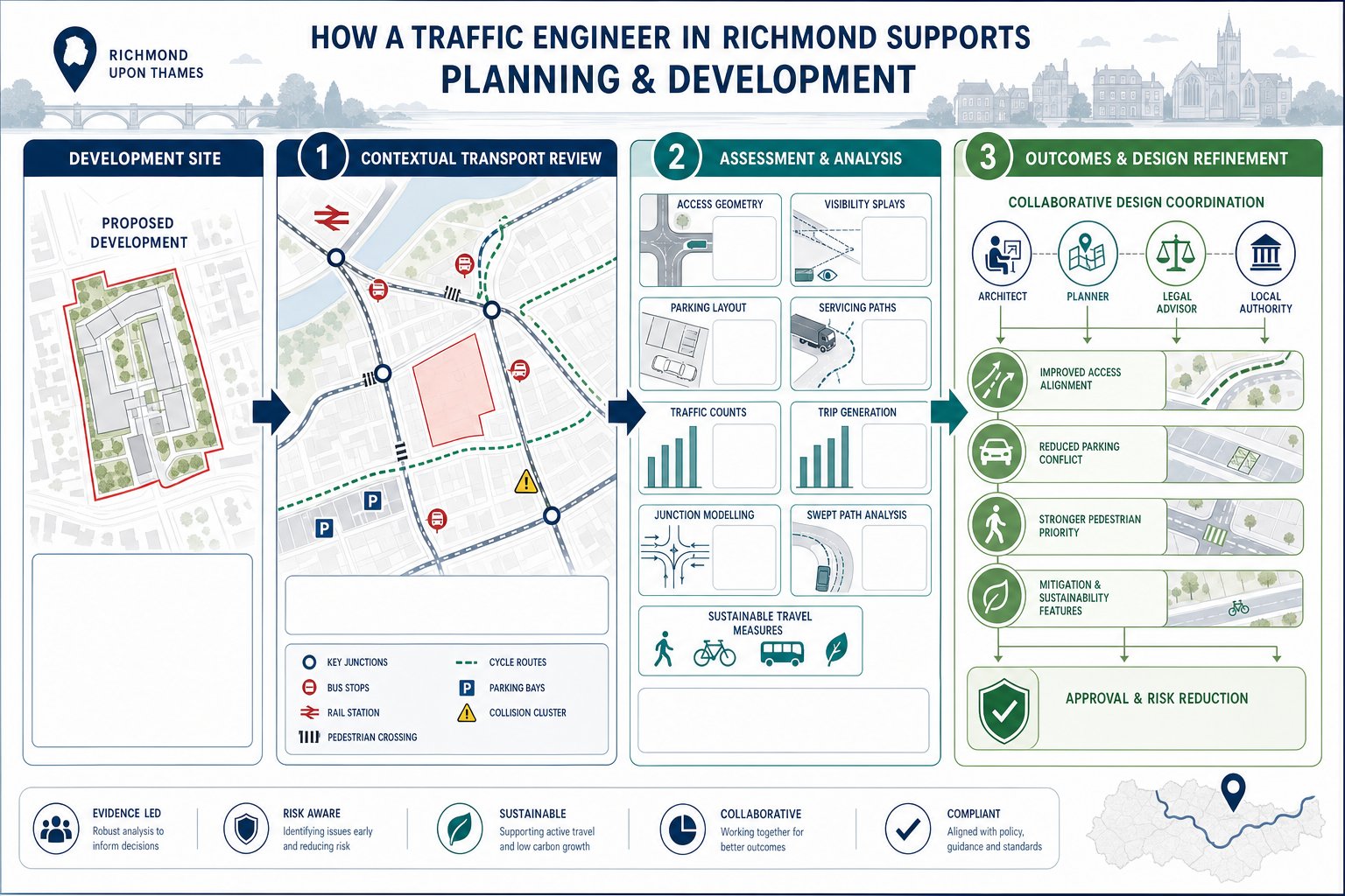
A traffic engineer in Richmond helps turn a planning concept into something that can stand up technically and procedurally. In practice, that means reviewing the site in its real transport context rather than only on a red-line plan. We look at the surrounding highway network, nearby junctions, bus stops, rail connections, pedestrian links, cycle routes, collision history, parking conditions and servicing constraints. Then we test whether the proposal fits.
For a small scheme, that work may focus on access geometry, visibility, parking layout and a proportionate statement of impact. For a larger or more sensitive development, it can involve traffic surveys, trip generation analysis, junction modelling, swept-path checks, Travel Plan measures and negotiation with the local authority over mitigation.
The role also sits between disciplines. Architects may need the access moved by a few metres. Planning consultants may need clearer evidence on policy compliance. Lawyers may want certainty on likely highway objections or planning conditions. A transport engineer helps tie those threads together.
Where schemes are constrained, we often advise on design changes early because they are cheaper to make before the application is fixed. That might mean refining a servicing arrangement, reducing parking conflict, improving pedestrian priority or adjusting trip assumptions. The broader value is practical: a robust transport submission reduces avoidable risk. Teams working with experienced Traffic Engineering Consultants: What tend to resolve the difficult questions before they become reasons for delay.
When Traffic Engineering Input Is Needed For A Richmond Planning Application
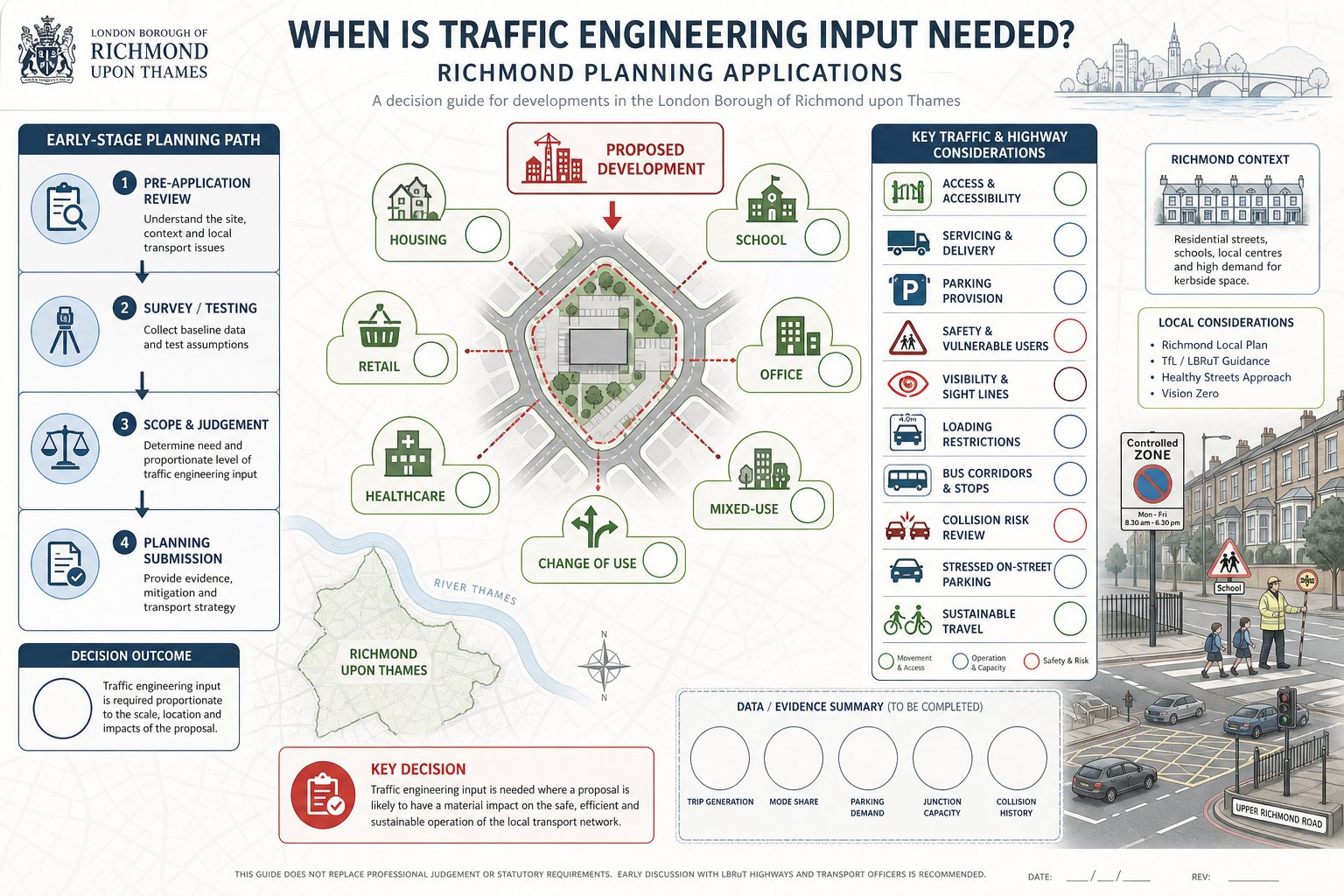

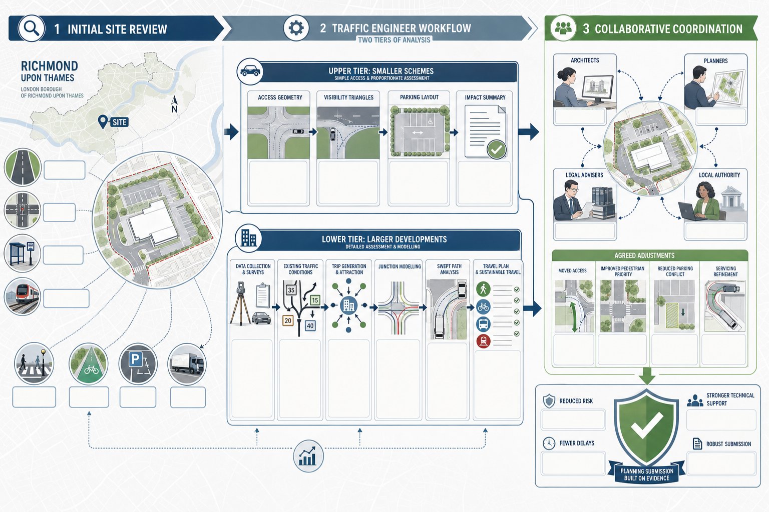
Traffic input is usually needed well before validation for anything beyond the most straightforward minor application. In Richmond, that includes new housing, education uses, retail schemes, offices, healthcare proposals, mixed-use projects and changes of use that could materially increase vehicle movements, servicing demand or parking pressure. Even relatively small developments can trigger transport concerns if the site sits on a narrow residential road, near a school, within a busy centre, or close to a sensitive junction.
Pre-application stages are often where traffic engineering adds most value. If access, servicing or parking are likely to be contentious, it is far better to test them early than to defend a weak arrangement later. We regularly find that a modest amount of early survey work and technical review prevents substantial redesign after submission.
There are also threshold questions. Some schemes clearly need a full assessment because of scale. Others need transport evidence because of context rather than size: poor visibility, loading restrictions, bus priority corridors, existing collision concerns, or already-stressed on-street parking. That judgement call matters. Under-scoping can make a submission look thin: over-scoping can create unnecessary cost and delay.
As a rule, if a proposal could change traffic patterns, affect safety, alter servicing activity or raise sustainable travel questions, a traffic engineer should be involved. Broader Highway And Traffic input is especially useful where planning teams need a realistic view of what the highway authority is likely to challenge.
Transport Statements, Transport Assessments, And Travel Plans Explained
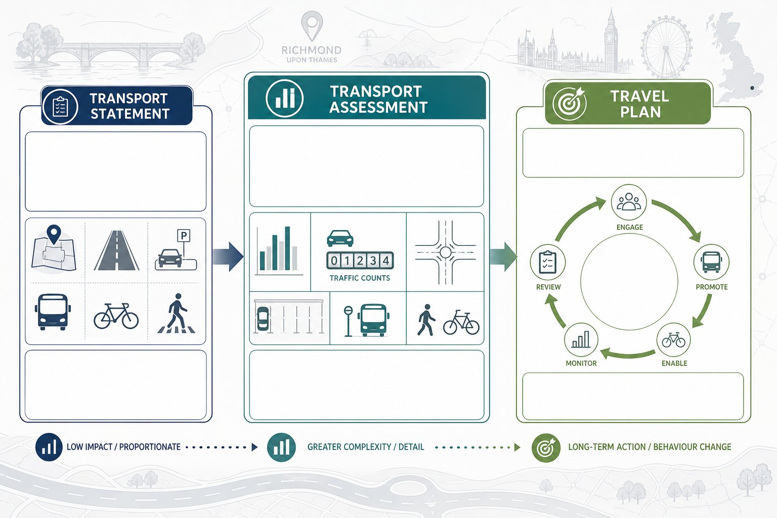
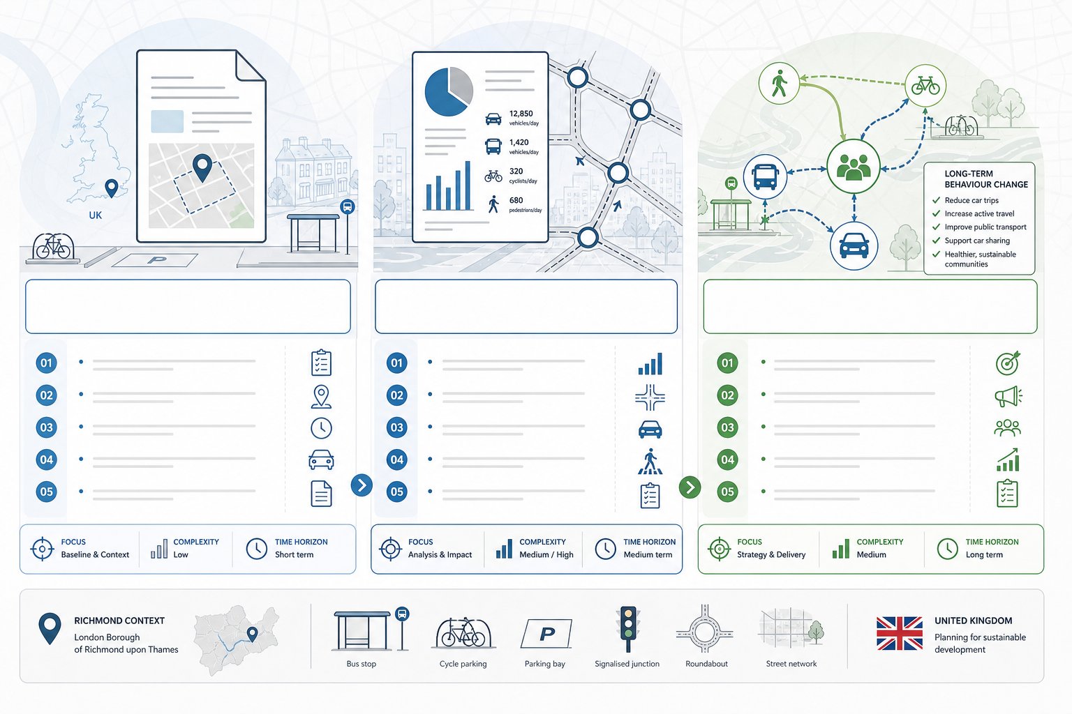
These documents are often grouped together, but they do different jobs.
A Transport Statement is generally a proportionate report for a smaller or less impactful scheme. It explains the site context, existing transport conditions, likely trip effects, access arrangements, parking, servicing and sustainable travel opportunities. The emphasis is on showing that impacts are limited and manageable without pretending the development is transport-neutral.
A Transport Assessment is more detailed. It is usually required for larger developments or sites where the authority needs fuller evidence on network impact. A TA may include multi-modal surveys, peak-hour traffic counts, trip generation from TRICS or comparable evidence, trip distribution and assignment, junction modelling, road safety review, parking analysis and mitigation proposals. The document should not be a data dump. Its strength lies in explaining why the methodology is appropriate and what the results mean for decision-makers.
A Travel Plan is different again. It is a strategy for influencing how people travel to and from the site over time. That can include mode share targets, cycle parking, public transport information, car club measures, staff incentives, monitoring and remedial actions. On many Richmond sites, especially where parking is constrained, the Travel Plan is not just an add-on: it is part of the planning case.
Used properly, these reports show proportionality and credibility. Our approach to Traffic Engineering and work is usually to start with scope, not paperwork, because the right report depends on both development scale and the sensitivity of the site.
How Development Impact On Richmond’s Road Network Is Assessed
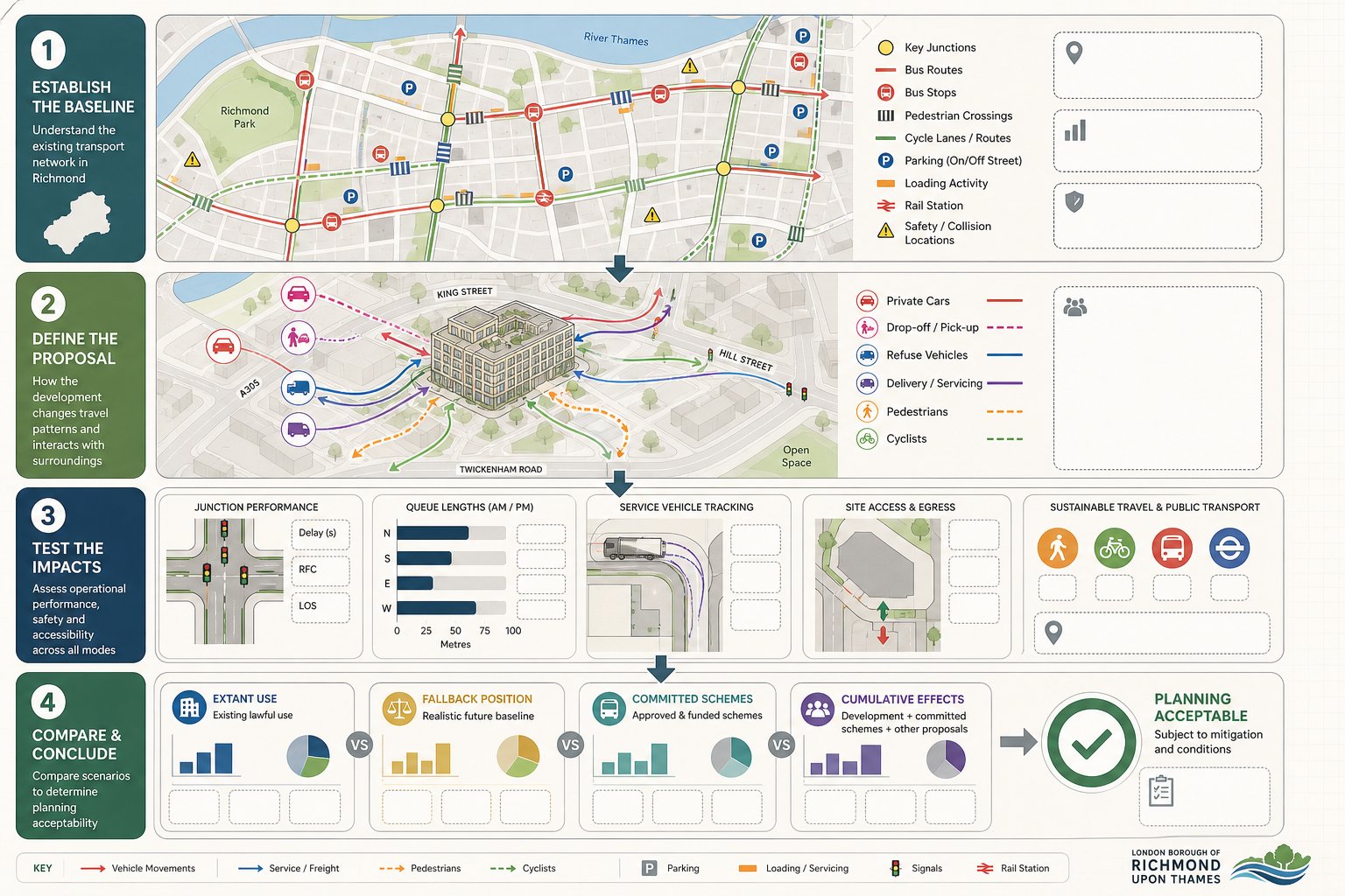
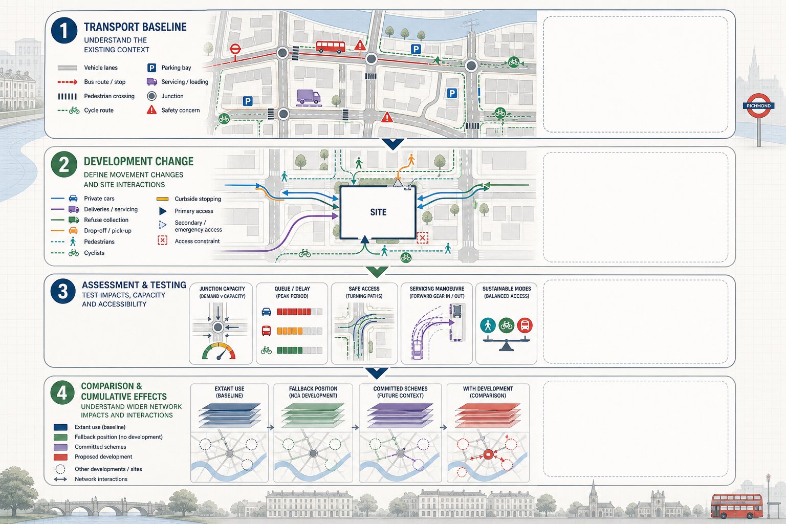
Assessing impact starts with understanding existing conditions rather than jumping straight to forecasts. We first establish the transport baseline: the road hierarchy, junction forms, traffic flows, bus operations, pedestrian movement, cycle conditions, parking controls, servicing patterns and any known safety issues. In Richmond, that baseline is especially important because many sites sit in networks that are already operating with little spare space.
From there, we examine how the proposed development would change movements. That includes vehicle trips, but also drop-off activity, refuse collection, deliveries, pedestrian arrivals, cycle demand and interactions with nearby uses. A residential infill scheme, for example, may generate modest traffic in pure numerical terms while still raising concern because of on-street parking pressure or constrained access. A school or medical use may create sharper peak effects and more short-stay stopping behaviour.
The assessment then tests whether those changes are acceptable. Are nearby junctions still likely to operate within reasonable limits? Will queues materially worsen? Is access safe and usable for all modes? Can service vehicles enter, turn and leave in forward gear where required? Does the development support walking, cycling and public transport in line with policy? Those are the practical questions authorities care about.
Good analysis is also comparative. We consider the extant use, fallback positions, committed developments and cumulative effects where relevant. That broader frame matters because highway impact is rarely judged in isolation. More detailed Traffic Engineering: Your evidence often becomes decisive where an application is being scrutinised closely.
Junction Capacity, Trip Generation, And Traffic Modelling
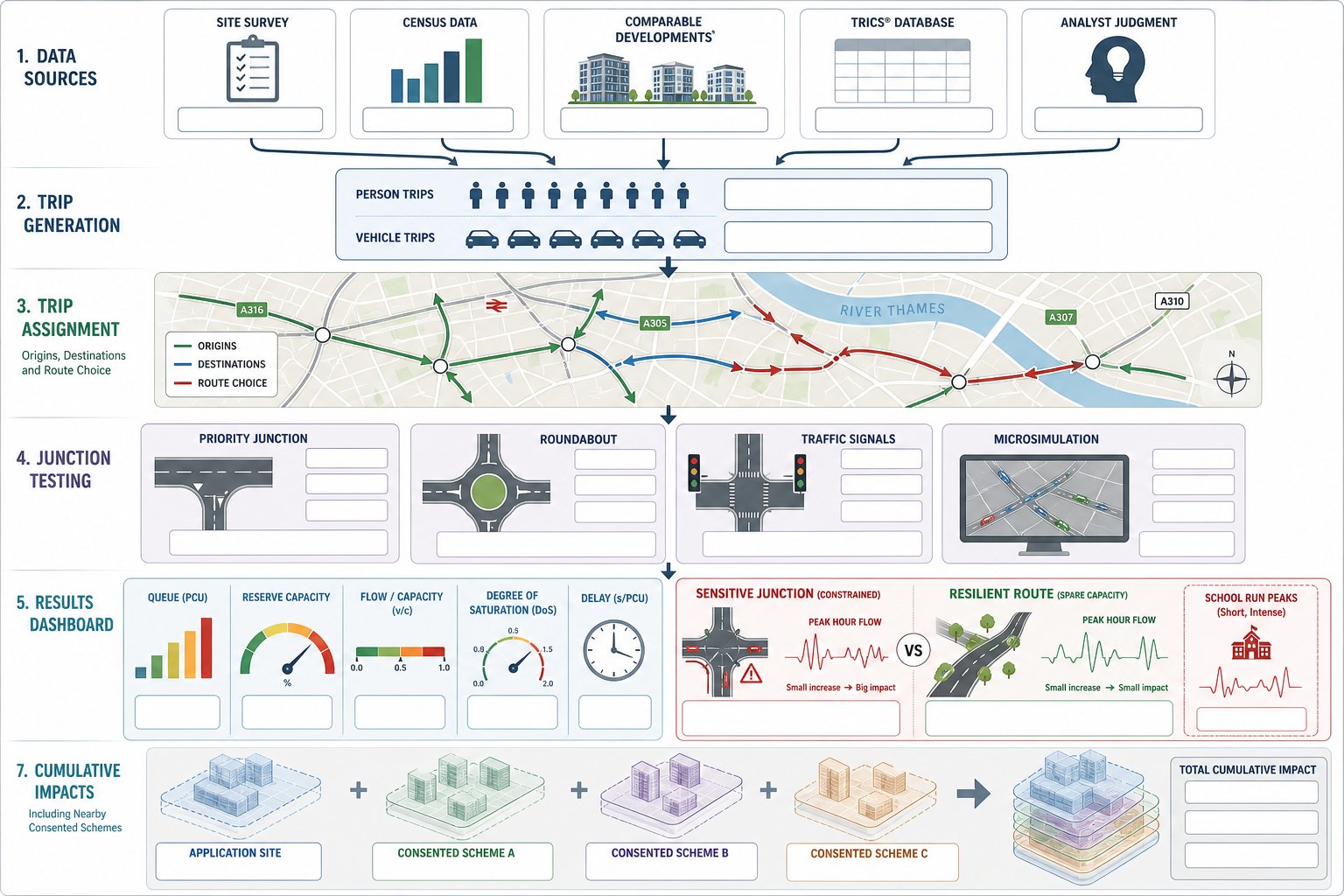
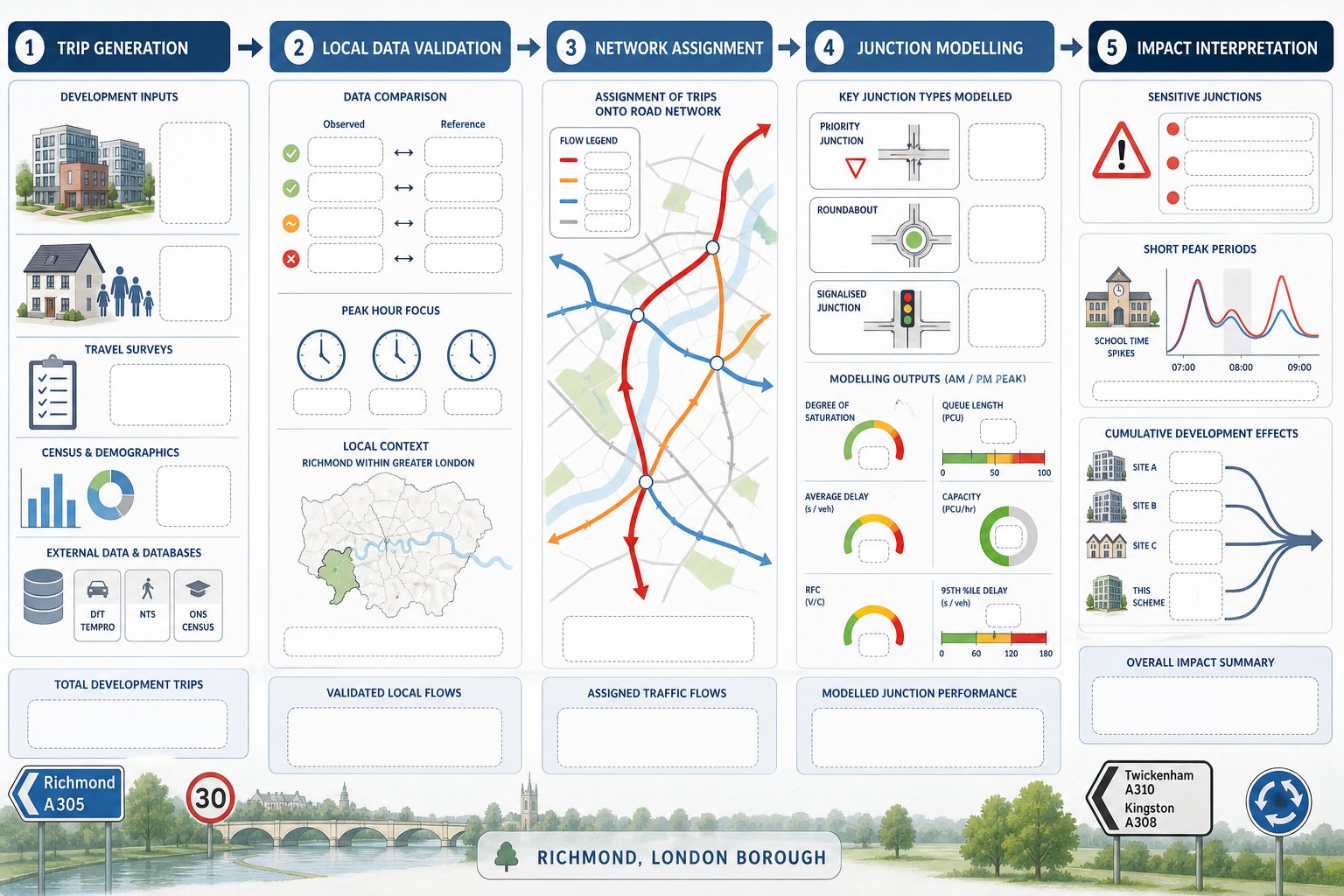
Trip generation is usually the first technical battleground. We estimate how many person and vehicle trips a scheme is likely to create, normally using TRICS data, census information, local surveys, comparable sites and professional judgement. But the numbers alone are not enough. The authority will want to know whether the selected sites are genuinely comparable, whether peak periods are appropriate, and whether assumptions reflect local travel patterns in Richmond rather than a generic suburban average.
Once trips are forecast, they are assigned to the road network based on likely origins, destinations and route choice. That allows us to test key junctions and links. Depending on the network, we may use priority junction models, roundabout models, signal models or, for more complex interactions, microsimulation. The outputs typically include queue lengths, reserve capacity, ratio of flow to capacity, degree of saturation and delay.
The numbers need interpretation. A small increase in flow at an already sensitive junction may matter more than a larger increase on a resilient route. Likewise, a network that works on average may still fail operationally for short, intense peaks, such as school start times.
Authorities will also expect cumulative thinking. If nearby consented schemes are likely to come forward, those effects may need to be included. For commercial or mixed-use development, a robust Commercial Traffic Engineering assessment can help explain both the model inputs and the practical significance of the outputs.
Parking Demand, Servicing, And Access Design Considerations
Some of the most stubborn planning objections in Richmond have less to do with strategic capacity and more to do with the everyday mechanics of a site. Where will people park? How will refuse be collected? Can a delivery van enter without mounting the footway? Will residents reverse blindly into a busy street? These are not minor details. They often shape the authority’s view of whether a scheme is genuinely workable.
Parking demand should be assessed against local and London-wide standards, but standards alone are not the full answer. Existing on-street parking stress, permit controls, PTAL context, disabled parking needs, electric vehicle charging and the likely behaviour of users all matter. In dense or sensitive areas, we often supplement standards with local parking surveys and a sharper review of likely overspill risk.
Servicing must also be realistic. For many developments, a neat vehicle tracking drawing is only the starting point. We need to consider delivery frequency, refuse strategy, loading restrictions, time-of-day constraints and whether service activity conflicts with pedestrian flows or school peaks.
Access design sits at the centre of it. Geometry, visibility splays, gradient, pedestrian crossing points, cycle conflict, gate setbacks and internal turning all need to work together. Poor access design can undermine an otherwise strong application, which is why detailed access design highway thinking is usually best done before the layout hardens.
Key Transport Issues That Affect Sites In Richmond
Richmond presents a distinctive transport planning environment because its development pressures sit alongside sensitive residential areas, active centres, strong sustainable travel expectations and a highway network that is often constrained physically as well as politically. That means similar-sized developments can receive very different responses depending on where they sit and how well the transport case reflects local conditions.
In practical terms, we often see three recurring themes. First, limited road space means the tolerance for poorly planned access or loading is low. Secondly, local concern about parking and rat-running can be intense, even where strategic traffic impact is modest. Thirdly, authorities increasingly expect developments to support mode shift in a measurable way, not simply acknowledge that buses and cycles exist nearby.
That local complexity is why generic transport text rarely lands well. A Richmond submission needs to show that the author understands the street in question, the likely user behaviour and the interaction between the proposal and everyday movement patterns. Whether the site is beside a school, in a centre, or on a narrower residential road, context does a lot of the heavy lifting.
Where planning teams need region-wide perspective as well as borough-level judgement, experience from a broader Traffic Engineer In London: context can help frame what is locally specific and what is simply good transport evidence.
Town Centre Constraints, Residential Streets, And School Traffic
Richmond town centres and local parades create a particular kind of transport challenge: high pedestrian activity, frequent servicing demand, bus movement, loading restrictions and very little slack in the carriageway. A proposal that adds only a handful of vehicle trips may still be problematic if it introduces awkward turning movements, obstructive loading or conflict with people crossing informally.
Residential streets raise different questions. Carriageways may be narrow, footways tight, and parking heavily utilised. Local residents are often quick to identify issues such as bin lorries blocking the road, delivery vans overhanging driveways or new accesses increasing conflict with parked vehicles. In these settings, the technical work has to be precise and grounded in observation, not assumption.
School traffic is another regular pressure point. Peak activity is concentrated, often chaotic, and highly sensitive from both safety and air-quality perspectives. If a site sits near a school, a transport submission should address pick-up and drop-off conditions, walking routes, crossing demand and whether development traffic or servicing could coincide with those peaks. Ignoring that context is a common way to invite objections.
We’ve found that authorities respond better when these local patterns are acknowledged plainly rather than minimised. A robust assessment can still support development, but only if it shows the team understands how the street really operates on a wet Tuesday at 8.30am, not just in a desktop average.
Walking, Cycling, Public Transport, And Accessibility Expectations
In 2026, it is no longer enough for a transport report to treat sustainable travel as a short policy appendix. Richmond applications are typically expected to demonstrate genuine support for walking, cycling and public transport, and to do so in a way that reflects actual user experience.
For walking, that means more than measuring distance to a bus stop. We look at route quality, crossings, footway width, lighting, gradients, legibility and step-free accessibility. A route that is technically short but unpleasant or inaccessible may not carry much weight with officers.
Cycling expectations are similarly practical. Secure and convenient cycle parking, visitor provision, access to the street, conflict-free movement through the site and links to nearby cycle infrastructure all matter. The quality of the internal arrangement can be just as important as the number of spaces shown on the drawing.
Public transport analysis should consider service frequency, reliability, catchment, interchange and whether likely users can reasonably depend on the available network. Accessibility planning also needs to reflect disabled users explicitly, including Blue Badge provision, dropped kerbs, tactile paving where relevant, and inclusive routes from boundary to entrance.
Parking restraint and sustainable access are closely linked, which is why a clear parking strategy traffic case often strengthens the wider planning argument rather than limiting it.
What Local Planning Authorities And Highway Authorities Typically Review
When Richmond’s planning and highway officers review a transport submission, they are usually testing two things at once: whether the evidence is technically robust, and whether the proposal aligns with policy objectives around safety, capacity and sustainable travel. A report can be mathematically tidy and still fall short if it ignores the borough’s real concerns.
Authorities commonly look first at scope and proportionality. Was the right type of report prepared? Were the correct peak periods surveyed? Has the assessment considered the extant use, committed development and the most sensitive nearby junctions? If those basics are weak, confidence drops quickly.
They then review methodology. Trip generation must be defensible, the selected comparison sites reasonable, and any modelling transparent. For access proposals, visibility, geometry, turning, pedestrian priority and road safety implications will all be checked. Parking and servicing arrangements are also scrutinised closely because they often drive day-to-day complaints after occupation.
Policy compliance is another major strand. Officers will want to see alignment with national guidance, the London Plan, local development policies and borough expectations on active travel and accessibility. Travel Plans are assessed for credibility too. A document full of vague aspirations tends not to carry much weight.
Eventually, authorities are asking a practical question: does this scheme work on the ground, and has the applicant proved it with enough clarity to justify consent?
How To Prepare A Stronger Transport Submission For Richmond
The strongest submissions usually start earlier and say less, but better. By that, we mean they agree scope early, collect the right data, and focus on the issues that actually matter to the site instead of padding the report with generic text.
First, involve a qualified traffic engineer as the layout evolves, not once the application pack is nearly finished. Early review can influence access position, servicing strategy, parking numbers, cycle provision and whether a Travel Plan should do more of the mitigation work.
Secondly, agree methodology where possible. Pre-application engagement with the local highway authority can clarify survey requirements, modelled junctions, assessment years and the level of detail expected. That does not guarantee agreement later, but it reduces the chance of arguments about basic scope.
Thirdly, present evidence clearly. Good plans, legible figures, mapped walking and cycling routes, swept-path drawings, parking surveys and transparent assumptions build trust. We also recommend addressing disabled users, bus access, pedestrian comfort and servicing constraints explicitly rather than treating them as footnotes.
Finally, tie the technical work back to the planning case. Explain how impacts are mitigated, why the proposal is proportionate, and how the scheme supports safer and more sustainable travel. On many applications, speed matters too. Providers such as ML Traffic are often brought in because concise, authority-aware reporting can help teams move faster without cutting corners.
Common Mistakes That Delay Transport Approval
The most common mistake is underestimating what the authority will care about. Applicants sometimes assume a scheme is too small to attract detailed scrutiny, then discover that a constrained access, stressed parking conditions or nearby school traffic changes the picture completely.
Another regular problem is weak trip generation. Using unsuitable comparison sites, selecting favourable rates without explanation, or ignoring committed nearby development can make the whole assessment look engineered to downplay impact. Once credibility slips, officers tend to interrogate everything else harder.
Missing or poorly timed surveys are also a frequent source of delay. If counts do not capture the relevant peak periods, or if parking surveys are too limited to demonstrate local conditions, the authority may simply ask for more work. The same goes for incomplete junction analysis where obvious stress points have been omitted.
Design errors create just as much trouble. Unsafe visibility, awkward refuse collection, insufficient turning space, inaccessible cycle parking or servicing that relies on unrealistic management assumptions can all hold up approval. Travel Plans are often weaker than they should be as well: vague aspirations without targets, measures or monitoring rarely persuade anyone.
And perhaps the most avoidable mistake of all is leaving transport too late. Once the site layout is fixed, improving a flawed access or servicing arrangement becomes much harder, and more expensive.
Conclusion
In Richmond, transport is rarely a box-ticking exercise. It is often one of the key tests of whether a development is credible, policy-compliant and practically deliverable. A capable traffic engineer in Richmond helps planning teams demonstrate that a scheme can be accessed safely, will not create unacceptable pressure on the local highway network, and supports walking, cycling and public transport in a meaningful way.
For architects, planners, developers, surveyors and councils, the real advantage lies in getting that advice early. When transport evidence is scoped properly, grounded in local conditions and tied closely to design, objections become easier to anticipate and resolve. That usually means a smoother planning route, fewer rounds of clarification, and a better development outcome overall.
In a borough as sensitive and varied as Richmond, that kind of technical clarity is not a luxury. It is part of what gets schemes over the line.
Frequently Asked Questions About Traffic Engineering in Richmond
What does a traffic engineer in Richmond do for planning applications?
A traffic engineer in Richmond assesses site access, local roads, junctions, parking, servicing, and sustainable travel options to ensure development proposals meet safety and policy standards, helping avoid objections and delays in the planning process.
When is traffic engineering input required for developments in Richmond?
Traffic engineering input is needed for most applications beyond simple minor ones, especially housing, schools, retail, offices, healthcare, or changes increasing traffic or parking pressure, typically during pre-application to influence access and design.
What is the difference between a Transport Statement and a Transport Assessment in Richmond?
A Transport Statement offers a proportionate review for smaller schemes focusing on impacts and access, while a Transport Assessment provides detailed multi-modal traffic analysis and mitigation for larger or more sensitive developments in Richmond.
How do traffic engineers assess development impact on Richmond’s road network?
They evaluate current traffic conditions through surveys, forecast trip generation using databases like TRICS, model junction capacities, and analyse queue and safety impacts to determine if a development’s traffic effects are acceptable.
Why is parking and servicing design important for Richmond planning approvals?
Because narrow roads and sensitive areas in Richmond require careful parking assessments, servicing plans, and access design to avoid conflicts, ensure safety, and meet local and London-wide standards to secure planning consent.
How can early involvement of a traffic engineer improve development planning in Richmond?
Engaging a traffic engineer early allows for addressing access, parking, and servicing challenges before finalising layouts, reducing revisions, ensuring policy compliance, and smoothing the approval process with local authorities.