Planning teams are under more pressure than ever to prove that development will create better places, not simply more traffic. That shift matters. Across England, transport evidence is no longer judged purely on whether a junction can squeak through peak-hour modelling. Increasingly, councils, design teams and applicants are being asked a tougher question: what kind of place are we actually trying to create, and does the transport strategy support it?
That is where vision led transport planning comes in. Rather than starting with forecast vehicle demand and then retrofitting mitigation, we begin with the desired future for the site and its surroundings: how people should move, what access should feel like, which modes should be prioritised, and how transport can reinforce wider planning goals. Those goals usually include accessibility, sustainability, health, economic vitality and a more resilient planning case.
For architects, planners, surveyors, developers, lawyers and local authorities, this is more than a change in terminology. It affects masterplanning, access design, transport assessments, stakeholder discussions and eventually planning outcomes. In our experience, the strongest submissions are the ones where transport thinking is embedded early and tied directly to place-making.
In this guide, we set out what vision led transport planning means in practice, how it differs from older predict-and-provide methods, what current policy expects, and how to prepare evidence that is realistic, robust and planning-ready in 2026.
What Vision-Led Transport Planning Means In Modern Planning Practice
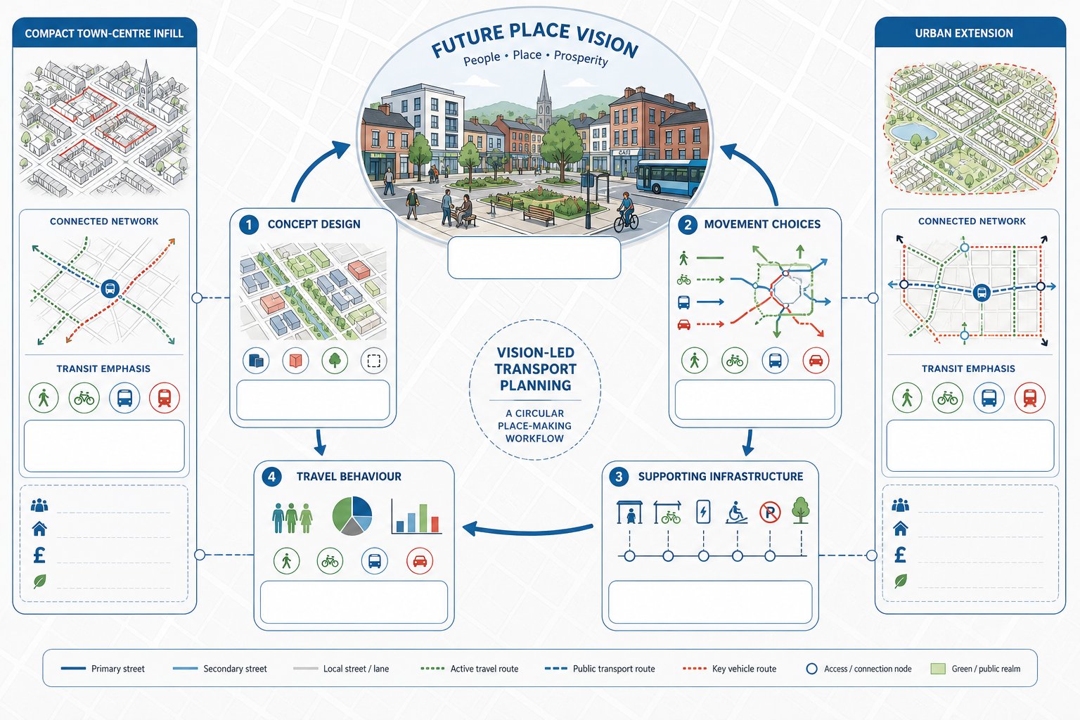
Vision-led transport planning starts with an agreed ambition for a place and works backwards to shape movement, land use and infrastructure around that ambition. In simple terms, we do not ask, “How much car traffic might this scheme generate, and how do we accommodate it?” first. We ask, “What sort of place should this become, how should people reach it, and what transport choices do we want to enable?”
That sounds subtle, but in planning practice it changes almost everything. It means movement is treated as part of place-making rather than a technical bolt-on. Walking routes, cycle permeability, public transport proximity, street hierarchy, parking restraint and access quality are considered at concept stage, not after the layout is largely fixed.
It is also an iterative approach. The vision informs the design, the design affects likely travel behaviour, and that travel behaviour then influences what mitigation or supporting infrastructure is genuinely needed. So we test options, refine assumptions and align transport evidence with the wider planning story.
This matters for schemes of all sizes. On a town centre infill site, it may mean leaning into existing accessibility and reducing car dependence. On a strategic urban extension, it may involve early bus strategy, connected walking and cycling networks, and land use patterns that shorten everyday trips. In both cases, the point is the same: transport planning should help deliver a better future place, not simply react to forecast traffic.
Why Vision-Led Planning Matters For Developers, Councils And Design Teams
For developers, a vision-led approach usually creates a stronger planning narrative and reduces the risk of late-stage redesign. If movement priorities are defined early, site layout, frontage design, access points and parking strategy can evolve in a coordinated way. That is often far cheaper than discovering, after transport modelling is complete, that the scheme conflicts with local policy aspirations or design quality objectives.
For councils, the benefit is clearer alignment between individual applications and wider objectives around decarbonisation, healthier travel, inclusive access and local economic performance. A development should not be assessed in isolation from the sort of settlement the authority is trying to create.
For architects and wider design teams, vision led transport planning keeps technical work grounded in spatial quality. Streets are not just corridors for vehicular throughput: they are public realm, front doors, social space and routes to schools, shops and bus stops. That perspective is especially useful when coordinating with Masterplan Transport Inputs: on larger or phased sites.
There is a practical commercial angle too. Schemes that demonstrate realistic mode share, proportionate mitigation and coherent access planning are often better placed in pre-application discussions. We see this regularly in Private Sector Transport Planning, where certainty and programme management matter almost as much as technical compliance. Better strategy early on tends to mean fewer surprises later.
How It Differs From Traditional Predict-And-Provide Transport Planning
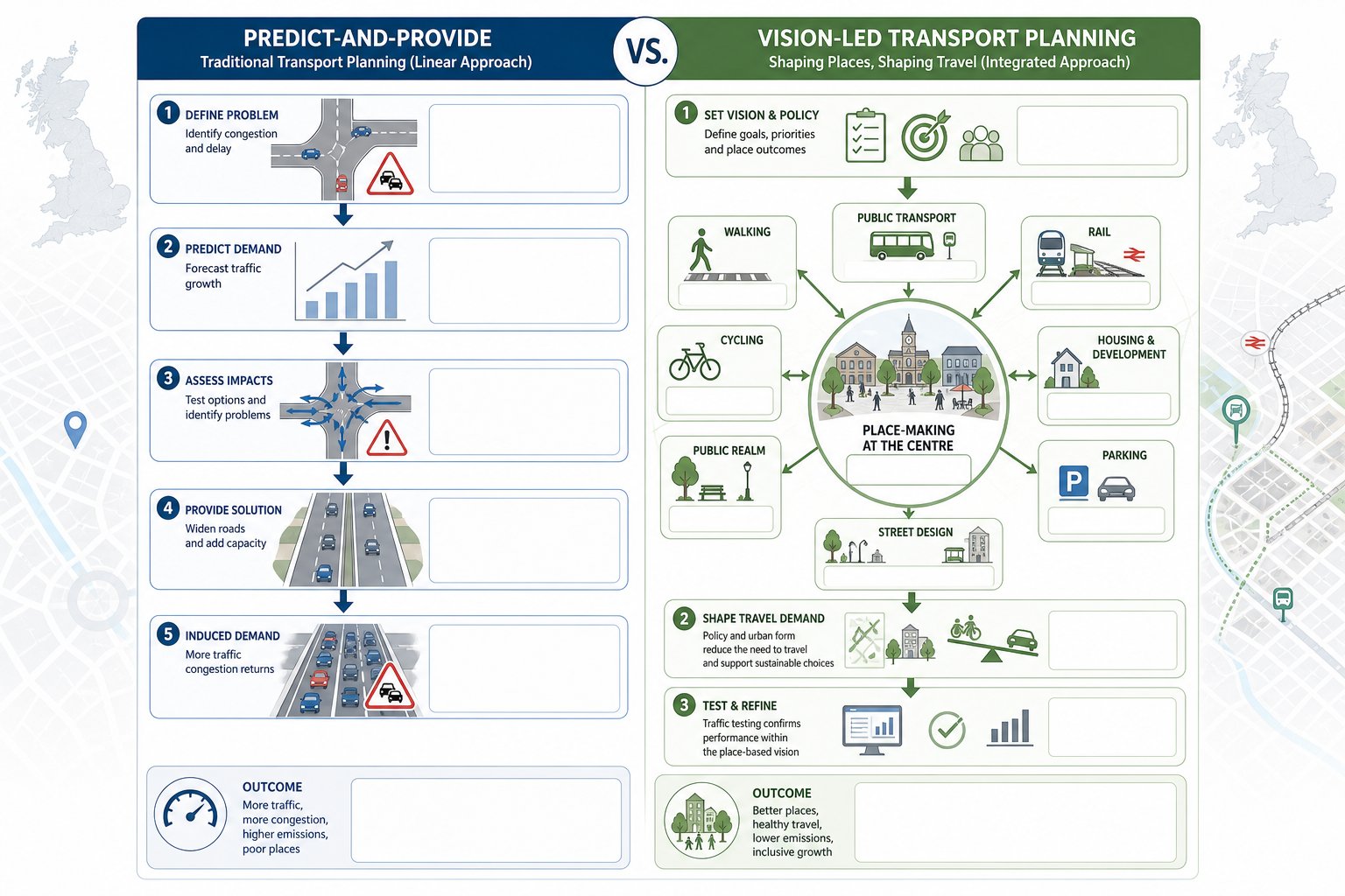
Traditional predict-and-provide planning follows a familiar sequence: estimate future traffic growth, identify pressure on junctions or links, and then propose capacity increases or mitigation to absorb the demand. That approach can be useful in a narrow engineering sense, but it often locks in car dependency. It assumes traffic growth is a given and that the transport system’s role is mainly to accommodate it.
Vision-led planning starts from a different premise. Travel demand is influenced by land use, urban form, accessibility, parking, route quality and public transport offer. In other words, movement patterns are not fixed: they are shaped by design and policy choices.
That does not mean ignoring traffic impact. Far from it. We still assess baseline conditions, trip generation, distribution, assignment and highway performance where relevant. But we do so within a broader framework. The key question becomes whether the development supports agreed place-based outcomes and whether traffic effects are acceptable in that context.
This is one reason a good Access Strategy Transport can be so valuable. It bridges architecture and transport evidence by setting movement principles before detailed testing. Put bluntly, predict-and-provide asks how to fit more movement into the network: vision-led planning asks how to create the right movement in the first place.
The Policy Context Shaping Vision-Led Transport Assessments
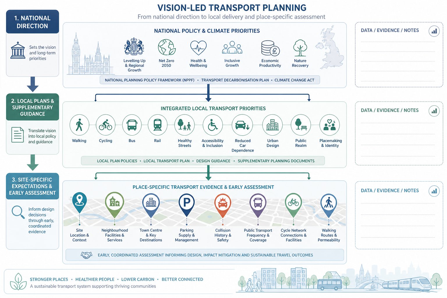
Policy support for vision-led transport planning is now broad enough that many authorities expect it, even where they do not use that exact label. National planning and transport policy has, for years, moved towards sustainable transport, healthy streets, accessibility and reduced reliance on the private car. Climate commitments have only sharpened that direction.
The practical implication is that transport evidence must do more than show a development is not catastrophic for road capacity. It should demonstrate that opportunities for walking, cycling and public transport have been identified and prioritised, that the site is connected credibly to local facilities, and that the proposal contributes to a pattern of development that is sustainable in transport terms.
That expectation also sits alongside design policy. Good planning submissions now link movement strategy with urban design, active frontage, public realm and placemaking. Transport is not a separate discipline off to one side: it is one of the ways policy ambitions are delivered on the ground.
For applicants, this makes early coordination essential. When our team prepares evidence quickly for live applications, local authority thresholds and local plan wording often shape both the depth of assessment and the framing of the argument. A generic transport report, dropped in late, rarely performs as well as one built around the policy and place context from the outset.
National Policy, Local Plans And Site-Specific Expectations
National policy sets the direction, but local plans, supplementary guidance and site allocations often determine the detail. One authority may place heavy emphasis on town centre accessibility and low parking provision. Another may focus on strategic bus delivery, school travel or cycling links to neighbouring communities. Site-specific expectations can go further still, especially on allocated land or politically sensitive schemes.
That is why the vision should be established early and tested against local evidence. We need to understand settlement hierarchy, nearby services, existing travel patterns, planned infrastructure, collision data, parking stress, public transport frequency and the authority’s appetite for mode shift. If a site is promoted through consultation, transport vision should be part of that conversation rather than an afterthought, which is where public consultation transport can genuinely improve outcomes.
Done well, policy alignment does not feel forced. The transport case simply reads as if it belongs to that place, under that plan, at that moment.
Embedding Place, Accessibility And Sustainability From The Start
If vision-led planning is going to work, it has to shape the scheme before technical positions harden. That means transport input at concept stage, when block structure, density, land use mix, frontage arrangement and access priorities are still fluid. Once a layout has been fixed around vehicle convenience, it becomes much harder to retrofit a genuinely sustainable movement strategy.
Embedding place from the start means asking practical questions. Can residents reach day-to-day services on foot in reasonable time? Are cycle routes direct, safe and coherent beyond the red line boundary? Is the bus stop merely nearby on a plan, or is it realistically attractive in terms of route choice, service frequency and waiting environment? Do disabled users experience the site as legible and convenient? And is parking calibrated to context rather than habit?
Accessibility is not just a map exercise. It is behavioural. People respond to friction, comfort, safety and directness. A nominal five-minute walk that involves hostile crossings, blank edges or poor lighting is not equivalent to a five-minute walk through a connected, active street network.
This is also where climate and public health objectives become concrete. Sustainable transport outcomes do not emerge from aspiration alone: they come from built form, street design, access strategy and everyday convenience. That is one reason Net Zero Transport Planning increasingly overlaps with mainstream planning evidence rather than sitting in a separate sustainability silo.
Setting Clear Movement Principles Before Testing Highway Impact
One of the biggest improvements a planning team can make is to define movement principles before diving into junction modelling. These principles might include pedestrian priority on internal streets, direct cycle access to surrounding routes, bus-compatible street geometry, parking levels linked to accessibility, or a servicing strategy that avoids undermining public realm quality.
When those principles are explicit, later technical testing becomes more meaningful. We can assess whether the proposed design supports the intended travel behaviour and whether any highway interventions are proportionate. Without them, there is a risk that modelling drives the scheme towards the path of least resistance: wider junctions, more tarmac and layouts optimised around peak-hour car movement.
In our experience, authorities are more receptive to transport evidence when they can see the logic chain. The place vision informs movement principles: movement principles shape design: design supports travel choices: and the assessment then tests impacts within that framework. It feels coherent because it is coherent.
That is especially important on complex sites where masterplanning, viability and phased delivery interact. If the principles are unclear, every later decision becomes a negotiation. If they are clear, the submission has an anchor.
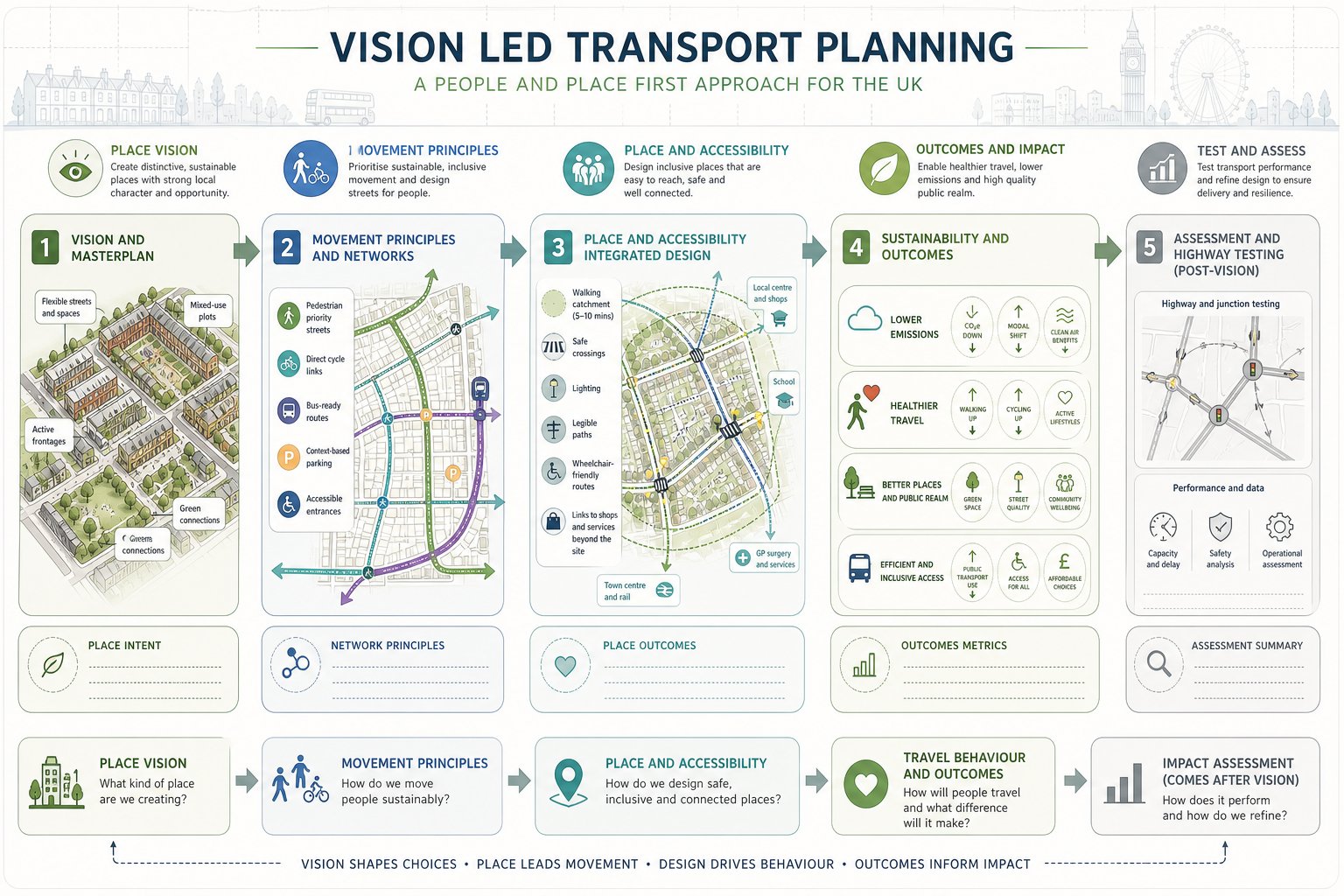
The Core Stages Of A Vision-Led Transport Planning Process
A sound vision-led process is structured, but not rigid. We usually think of it in five linked stages.
First, define the vision. What are the development’s movement outcomes, and how do they support the wider planning objectives for the site and area?
Second, establish the place and accessibility baseline. That includes land use context, existing travel options, network constraints, public transport quality, local facilities and likely barriers to mode shift.
Third, shape the scheme around movement priorities. Access points, internal street design, parking, servicing, pedestrian links, cycling provision and links to nearby destinations should all reflect the agreed vision.
Fourth, test realism. This is where trip generation, distribution, assignment, capacity checks and sustainable mode potential are assessed in a proportionate way. The purpose is not to abandon evidence, but to ensure evidence matches the scheme being promoted.
Fifth, secure delivery and monitoring. Travel plans, infrastructure triggers, phased interventions and post-occupation review can all be important, particularly for larger or mixed-use proposals.
The process is iterative because findings at stage four may prompt refinement at stage three. That is healthy. The strongest reports are rarely produced by a linear one-pass exercise: they come from testing, adjusting and improving.
Site Analysis, Trip Realism And Multi-Modal Access Planning
This is where weaker submissions often unravel. Site analysis must be honest about both strengths and constraints. If public transport is limited, we need to say so and address what can realistically be improved. If walking links are severed by major roads or poor crossings, glossy accessibility plans will not rescue the argument.
Trip realism matters just as much. Over-optimistic mode share assumptions are easy to spot and quick to undermine. Councils and highways officers will ask whether the site design, local context and supporting measures genuinely justify the claimed reduction in car use. The answer should rest on evidence, comparables and design quality, not wishful thinking.
Multi-modal access planning means looking beyond the site entrance bellmouth. It includes pedestrian desire lines, cycle route continuity, secure parking, bus stop quality, service frequency, school access, freight management and the relationship between internal layout and external connectivity. On complex schemes, mixed use masterplan thinking is often essential because different uses generate different trip patterns across the day.
Good transport planning is rarely about one big intervention. More often, it is the cumulative effect of sensible design decisions that make sustainable choices easier, more obvious and more attractive.
Designing Development That Supports Walking, Cycling And Public Transport
A development does not support sustainable travel because a report says it does. It supports sustainable travel when the physical design makes those modes convenient and intuitive.
For walking, that means direct routes, overlooked streets, safe crossings, minimal detours, strong links to surrounding destinations and entrances placed where people actually want to go. Internal permeability is crucial. If pedestrians are forced onto indirect or secondary routes while vehicles get the obvious line, the hierarchy is wrong.
For cycling, we need route continuity, secure and usable parking, sensible gradients where possible, and clear connections to the wider network. Token cycle stores hidden in awkward corners are not enough. Nor are painted lines that disappear at the site boundary.
For public transport, the design should acknowledge actual user experience. How far is the walk to the stop? Is it step-free? Is the waiting environment decent? Can buses move through or past the site efficiently? On larger developments, early engagement with operators can be the difference between a nominally serviceable site and one that genuinely functions without heavy car reliance.
Parking and servicing matter too. Excessive parking can undermine the mode share narrative, but inadequate or poorly arranged parking can create overspill and local opposition. The answer is context-sensitive balance.
This is often where experienced Transport Planning Consultants: add real value: translating broad sustainable transport aims into site layouts that can survive both technical scrutiny and commercial reality.
Preparing Transport Assessments And Statements Using A Vision-Led Approach
A vision-led Transport Assessment or Transport Statement still needs technical rigour. The difference is that the document should explain how transport supports the development concept, not just quantify residual traffic effects.
In practice, that means the report should begin with the site’s policy and placemaking context, identify movement objectives, and explain how the scheme responds through layout, access, connectivity and mode choice. Baseline conditions, trip generation, distribution and impact testing remain important, but they should sit within that wider narrative.
The evidence also needs to be proportionate. Not every site requires a sprawling assessment packed with model outputs that add little value. Equally, a concise statement should not duck key issues. The right level of detail depends on scale, context, sensitivity and local thresholds. That is why a tailored transport assessment for planning applications tends to perform better than an off-the-shelf template.
A strong vision-led submission will usually include:
- a clear statement of movement and place objectives:
- honest accessibility analysis:
- realistic trip generation and modal assumptions:
- a coherent access and parking strategy:
- proportionate highway testing where required:
- measures that support walking, cycling and public transport: and
- delivery mechanisms such as travel plans or trigger points.
Most importantly, the report should read as though the transport strategy and development design were conceived together. If they appear disconnected, decision-makers notice.
Common Risks, Objections And How To Strengthen A Planning Submission
The most common weakness in transport submissions is internal inconsistency. A report may talk about mode shift and healthy streets, while the layout prioritises vehicle circulation and the parking provision signals business as usual. That gap is often where objections begin.
Another frequent problem is over-reliance on traffic modelling. Modelling has its place, but it cannot compensate for a poor access strategy or an unconvincing sustainability case. If the development is fundamentally misaligned with policy aspirations for the area, extra decimal points on a junction assessment will not solve it.
We also see issues where applicants overstate accessibility. A bus stop on a plan is not proof of meaningful public transport access. A nearby footway is not proof of a pleasant or safe walking route. Scrutiny tends to focus on lived conditions, not just measured distances.
To strengthen a submission, we should tighten the logic from vision to design to evidence. Show how movement principles influenced the layout. Be realistic about likely travel behaviour. Address constraints openly. If off-site measures are needed, explain timing, deliverability and responsibility. And where consultation has shaped the scheme, say so clearly.
For planning teams working to programme, speed matters, but clarity matters more. Concise, accurate reporting grounded in local authority expectations usually stands up best. A well-prepared submission does not try to hide the hard questions: it answers them before they become objections.
Conclusion
Vision-led transport planning is not a soft alternative to technical assessment. It is a better framework for it. By starting with the future place we want to create, we can align transport evidence with policy, design quality, sustainability goals and realistic travel behaviour from the outset.
For developers, councils and design teams, that usually leads to stronger planning narratives, fewer late surprises and more defensible submissions. The key is simple enough: define the vision early, translate it into clear movement principles, test the scheme honestly, and make sure the design actually supports the outcomes being claimed.
In 2026, that is increasingly what good planning looks like. Not transport planning as a narrow exercise in accommodating forecast traffic, but transport planning as part of making places that work better for people. When the evidence, design and policy story all pull in the same direction, planning outcomes tend to improve as well.
Frequently Asked Questions about Vision-Led Transport Planning
What is vision-led transport planning?
Vision-led transport planning starts with a desired future place and works backwards to design movement, land use, and infrastructure that support accessibility, sustainability, and health. It prioritises walking, cycling, and public transport over simply accommodating forecast car traffic.
How does vision-led transport planning differ from traditional predict-and-provide methods?
Unlike predict-and-provide, which focuses on forecasting traffic growth and then adding capacity, vision-led planning establishes place-based movement principles first. It tests how transport can support desired outcomes, shaping travel behaviour rather than assuming fixed demand.
Why is embedding place and sustainability early important in transport planning?
Embedding place and sustainability at the concept stage ensures that walking routes, cycle access, public transport proximity, and parking strategies are integrated from the start. This approach avoids costly redesign and helps deliver genuinely sustainable movement patterns that align with local policy goals.
What are the typical stages involved in a vision-led transport planning process?
The core stages include defining the vision, assessing the place and accessibility baseline, shaping the scheme around movement priorities, testing realism of trip generation and mode share, and securing delivery with monitoring mechanisms to ensure ongoing alignment with planning objectives.
How can developers and councils benefit from vision-led transport planning?
Developers gain coordinated site layouts and stronger planning narratives that reduce redesign risks, while councils see enhanced alignment with decarbonisation, healthier travel, and economic vitality goals. This approach supports sustainable urban growth that meets local community aspirations.
What common pitfalls should be avoided in vision-led transport submissions?
Submissions often falter due to internal inconsistencies between stated mode shift ambitions and actual design, over-reliance on traffic modelling, and unrealistic accessibility claims. Strengthening the logic chain from vision to design and evidence, and addressing constraints openly, improves approval chances.