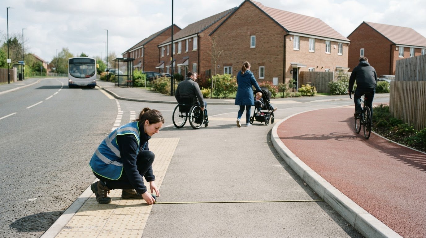
Short journeys are where walking and cycling can become practical alternatives to driving. A walking and cycling strategy sets out how an area can make these journeys safer, more accessible and easier to choose. Understanding what a walking and cycling strategy is also means seeing how local plans connect with wider national ambitions.
A strategy involves more than adding cycle lanes. Good planning considers who can use a route, where it leads and how it fits everyday journeys, including trips to schools, shops and public transport. Accessible routes matter too, so people walking, using wheelchairs or mobility scooters, or travelling with pushchairs can get around more easily.
This article explains the main aims of walking and cycling strategies in the UK, from supporting health and inclusive access to encouraging active travel for short trips. It also outlines the national direction and how transport planning evidence can help development proposals account for walking and cycling connections.
Key Takeaways
- A walking and cycling strategy sets priorities for making active travel safer, more accessible and easier to choose.
- Well-planned routes can support everyday physical activity while connecting homes with schools, local services and public transport.
- Inclusive route design considers the needs of disabled and older people, as well as those walking with pushchairs or luggage.
- Short journeys are a key opportunity to make walking and cycling practical alternatives to driving.
- Transport planning evidence can help development proposals account for access, movement and connections to active travel routes.
Health and environmental benefits of walking and cycling
Walking and cycling strategies support healthier travel choices and shape routes around everyday destinations. Their benefits depend on connected, usable infrastructure, not simply plans on paper.
Benefits for Health
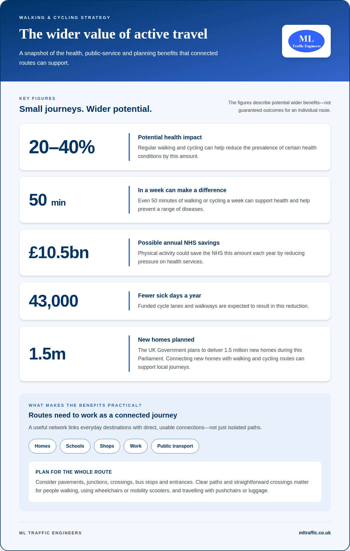
Walking and cycling build physical activity into routine journeys, such as trips to school, shops or work. Regular movement can support health and help reduce the prevalence of certain health conditions by 20% to 40%. Even 50 minutes of walking or cycling a week can make a difference to health and help prevent a range of diseases.
The benefits can also reach public services and workplaces. Physical activity could save the NHS £10.5 billion each year by reducing pressure on health services. Funded cycle lanes and walkways are expected to result in 43,000 fewer sick days a year. These figures describe potential wider benefits, rather than guaranteed outcomes for an individual route.
Benefits for the Environment
Walking and cycling can replace some journeys by motor vehicle, reducing the exhaust emissions from those trips. Fewer car journeys can also ease traffic pressure around schools and local centres. The practical benefit for residents depends on routes being direct and connected to the places they need to reach.
New development makes that planning especially relevant. The UK Government plans to deliver 1.5 million new homes during this Parliament. Connecting homes with walking and cycling routes can support local journeys without relying on a car for every trip. Environmental gains depend on how people travel, where routes lead and whether the network forms useful connections.
What UK laws and design standards apply to walking and cycling infrastructure? Local schemes must take account of applicable planning, highway and accessibility requirements, along with relevant design guidance. Requirements depend on the scheme and its location, so proposals need to consider route users, safety and access in their specific setting.
How is a walking and cycling strategy developed and approved? Councils identify local travel needs, set priorities and develop route proposals and supporting measures. They consult on draft plans, then follow the relevant local approval process before implementation.
How are walking and cycling strategies funded in the UK? Funding can come through national programmes and allocations to local authorities.
How do councils consult residents on walking and cycling strategies? Councils can invite residents to comment on proposals through surveys and consultations. Hounslow’s consultation on walking, wheeling and cycling opened on 24 October 2024 and closed on 19 January 2025; its survey was estimated to take 7-10 minutes.
How is the success of a walking and cycling strategy measured? Measures can include changes in walking and cycling journeys, route use and safety outcomes. A proposed national performance indicator is to reduce pedestrians and cyclists killed or seriously injured; another proposed indicator focuses on the share achieving 150 minutes of activity a week through active travel by 2030.
What are common criticisms and risks of walking and cycling strategies? Concerns can arise when proposed routes affect access, parking or traffic movement, or feel disconnected from everyday destinations. Limited consultation or poor connections can also reduce use. Plans need to reflect local needs and show how each route fits the wider network.
How can I find my local council’s walking and cycling strategy? Search the council’s website for its walking, cycling or active travel strategy, or look in its transport and planning policy pages. The council’s consultation pages can show whether a plan is being developed or has been adopted.
Accessible routes for disabled and older people
An accessible walking and cycling network must work for people with different mobility, sensory and stamina needs. A route is useful only if people can follow it, cross roads and reach everyday destinations without avoidable barriers. For an older person using a walking aid, for example, a short gap or difficult crossing can make an otherwise convenient journey impractical.
Planning should consider the whole journey, not just a new path. A route between homes and a local shop may include pavements, junctions, crossings, bus stops and entrances. If one part is difficult to navigate, the rest may not provide a reliable connection. Councils can map these links and identify where barriers interrupt access.
Common points to examine include pavement condition, obstructions, crossing opportunities and interactions between people walking and cycling. Street furniture, parked vehicles or temporary works can narrow a clear route. At a junction, people may need enough time and a straightforward way to cross. The appropriate design response depends on the location and its expected users.
Hounslow’s definition of wheeling includes people using wheelchairs or mobility scooters, and people travelling with pushchairs or luggage at walking pace. It excludes cycling. This distinction helps councils consider different users rather than treating every journey on foot as the same. A wheelchair user and a person pushing a pram may both need a clear path, but their route choices and turning movements can differ.
Older people may benefit from routes that connect essential destinations and include places to pause and clear crossing points. A journey to a health centre, for instance, involves more than the distance between home and the building. The route’s continuity, surface and street layout can affect whether the full trip feels manageable. Plans should assess connections around destinations, not just major corridors.
Residents can identify practical barriers that a map alone may not show. Councils can use consultation to learn which crossings feel difficult, where obstructions recur and which destinations need better links. They can compare these concerns with observations of routes and local movement patterns. This makes accessibility part of project prioritisation, rather than a final design check.
For new development, a Travel Plan can support consideration of how people access a site and make everyday journeys. Connecting site entrances with existing pedestrian routes helps place accessibility within the wider journey, rather than treating the boundary as the end of the route.
Encouraging walking and cycling for short journeys
Short trips are a practical opportunity to replace some car journeys with walking, wheeling or cycling. Hounslow’s active travel approach aims to shift short car trips to these modes where possible, while encouraging public transport for longer journeys. A trip to a local shop, school or nearby station shows how route planning can support that shift. The key is making the whole journey direct and workable.
Route continuity matters. A path that ends before a school entrance or busy junction may not help families complete the journey on foot. Councils can plan connections between residential streets, schools, neighbourhood centres and transport hubs. In England, planned safer routes are intended to connect these destinations, with work beginning in autumn 2025. The programme aims to create over 3,500 miles of routes.
School journeys are a clear example of how one network can serve several needs. Safer connections may make it easier for children and parents to walk to school, while also linking nearby homes with local facilities. The schemes are expected to support more than 20million new walk-to-school journeys by children and their parents every year. These connections can make walking part of an ordinary daily routine.
Greater Manchester offers a local example of change over time: the share of people walking short journeys was 57 per cent, up from 52 per cent five years earlier. That comparison shows why strategies need to consider whether routes connect useful destinations, rather than simply measuring new infrastructure. Walking may suit a nearby errand, while a longer trip could combine cycling or walking with public transport.
Practical barriers also influence travel choices. Hounslow describes walking and wheeling as options requiring no cost, equipment or training. Cycling involves basic training and some investment in a bike, which can be hired, loaned or bought. A local strategy can account for these differences by linking routes to suitable destinations and considering how people access cycling opportunities.
- Map short trips to schools, shops, neighbourhood centres and transport hubs.
- Identify route gaps that interrupt a journey, especially near junctions and entrances.
- Consider walking, wheeling, cycling and public transport as options for different trip lengths.
- Review local travel patterns over time to understand whether the network supports everyday journeys.
For residents, the aim is to offer choices that fit the journey. A connected route can make walking practical for a nearby errand, while safe links to a station can support a longer public transport trip. A strategy coordinates these connections so short journeys have realistic alternatives to driving.
National vision for walking, wheeling and cycling
The national direction links everyday active travel with safer, easier and more accessible journeys. Its value for local areas lies in translating broad ambitions into connected routes, usable public spaces and measurable progress.
The proposed UK government vision is for walking, wheeling and cycling to be safe, easy and accessible options for everyone by 2035. It also aims to give 20 million more people in target areas the opportunity to be active daily. These goals make inclusion and regular activity central to national planning, rather than separate considerations for individual schemes.
The UK Department for Transport’s walking and cycling strategy sets out ambitions to achieve by 2040. The third Cycling and Walking Investment Strategy, known as CWIS3, is intended to run from 2025 to 2030. Together, these timeframes provide a national context for local strategies, which can identify priorities suited to their streets, communities and travel patterns.
National ambitions depend on local delivery. Councils shape proposals around their networks, destinations and barriers, then coordinate planning and implementation. For example, a local route might connect homes with a station, school or town centre. A useful network considers how these links join up, so a new section does not end before people reach their destination.
Performance measures help turn a vision into practical objectives. One proposed CWIS3 indicator is increasing the percentage of people achieving 150 minutes of activity a week through active travel by 2030. A measure like this focuses attention on whether walking and cycling form part of daily life, rather than counting infrastructure alone. Local monitoring can also reveal where route changes are not translating into greater use.
The Infrastructure Act 2015 provides a statutory basis for cycling and walking investment strategies. Section 21 (3a) requires the UK government to set objectives for each strategy, while Section 21(5) requires the Secretary of State to consult on one. These provisions connect national objectives with consultation and published strategy-making.
Who creates and delivers a walking and cycling strategy in the UK? The UK government sets national objectives and investment strategy, while local authorities develop and deliver local plans. Their work connects national ambitions with local routes, priorities and implementation.
For residents, the national vision offers a way to assess whether local proposals support wider aims. Look for clear links between route improvements, access to everyday destinations and stated outcomes. A local plan that explains these connections makes it easier to understand how a scheme contributes to the UK’s direction through 2035 and 2040.
What are the aims of a local walking and cycling strategy in the UK?
A local strategy turns broad active travel ambitions into priorities for a particular area. It identifies where walking and cycling routes should connect, which barriers need attention and how progress can be assessed.
One aim is to create a connected network linking homes with everyday destinations. Greater Manchester, for example, aims to place 95% of its residents within 400m of high-quality active travel routes. This target shows how a council can express its ambition in practical terms: route quality and proximity both matter, not just the number of schemes delivered.
Safety is a central priority. A proposed UK government local authority performance indicator is reducing the number of pedestrians and cyclists killed or seriously injured. Local plans can use this focus to identify safety concerns, prioritise locations and assess whether proposed changes support safer movement. This makes safety an explicit outcome of network planning.
Strategies also set priorities for access and inclusion. A council can identify destinations without useful walking or cycling connections, then consider how proposed routes serve different users. For example, a link to a local centre may need to work for people approaching from residential streets as well as those connecting from public transport.
Clear objectives help councils explain why one project takes priority over another. A strategy might identify a missing connection, describe the destinations it would serve and set out the intended outcome. This makes it easier to assess a proposal against local needs, rather than judging it only by its length or visibility.
- Map gaps between neighbourhoods and schools, high streets or transport hubs.
- Identify locations where pedestrian and cycling safety needs focused attention.
- Consider whether routes work for people with different mobility needs.
- Set measures that track safety, access and active travel use over time.
Delivery depends on coordination. A proposed route may involve several streets, destinations or transport connections, so councils need to consider how each part fits the wider network. Monitoring can compare outcomes with the strategy’s objectives and inform future priorities. For example, councils can assess whether route links improve access and whether safety measures address identified concerns.
A local strategy is most useful when its aims guide decisions from planning through delivery and review. For development proposals, transport planning evidence can help explain how site access and movement relate to local priorities. Explore transport planning support for development-related movement and access considerations.
Long-term priorities also need to match delivery capacity and funding. Councils can use a strategy to explain how proposed walking and cycling links meet local needs and how investment supports its aims.
Evidence of delivery can help build confidence in active travel planning. Local authorities supported by Active Travel England have completed active travel projects at more than twice the rate of other small transport schemes. This illustrates why clear priorities, coordinated implementation and monitoring matter: they help turn network plans into completed improvements and provide a basis for refining future decisions.
ML Traffic Engineers UK
ML Traffic Engineers UK helps development teams understand transport considerations related to walking and cycling access. For planning applications, its Transport Statements and Transport Assessments set out relevant transport matters, while Swept Path Analysis and Parking Surveys provide project-specific analysis where needed.
Use this support when a proposed development needs transport documentation or evidence explaining how it relates to local movement priorities. The right work depends on the proposal and the transport questions it needs to address.
To discuss transport planning support for your development, contact ML Traffic Engineers UK.
Turn active travel priorities into informed decisions
As a development moves from early proposals towards a planning application, its relationship with local travel priorities deserves attention. Understanding what a walking and cycling strategy means can help frame questions about site access, connections and supporting transport evidence.
The next step is to connect the policy context with the specific development. The location, proposed access and surrounding movement network all shape which transport documents and analysis are relevant. Clear, project-specific evidence explains how a proposal relates to its setting without treating every site alike.
ML Traffic Engineers UK can support development proposals with transport planning documentation and analysis tailored to the project. If you are assessing transport considerations for a development, discuss your project with ML Traffic Engineers UK. A well-informed next step can help you approach planning decisions with greater clarity.
Frequently Asked Questions
What is a walking and cycling strategy?
A walking and cycling strategy is a coordinated plan to improve how people travel on foot or by bike across an area. Unlike an individual path proposal, it considers how routes and destinations fit together across a wider network. For example, a council can use its strategy to assess whether a planned link connects effectively with existing streets and the places people need to reach.
What does a walking and cycling strategy typically include?
A typical strategy brings together an assessment of current travel conditions, a vision for future movement and priorities for action. It may include maps of existing routes and gaps, objectives for improving the network, and criteria for prioritising proposals. A council might use these elements to compare a connection near a school with a route serving a local centre, then explain how each supports its wider plan.

Disclaimer
The content on mltraffic.co.uk, including all technical articles, guides, and resources, is provided for general informational and educational purposes only. It is not intended to constitute professional advice in traffic engineering, transportation planning, development approvals, or any other technical or legal field.
While ML Traffic Engineers makes every reasonable effort to ensure the accuracy, completeness, and timeliness of the information published, we do not provide any warranties or representations (express or implied) regarding its reliability, suitability, or availability for any particular purpose. Any reliance you place on the content is strictly at your own risk.
In no event shall ML Traffic Engineers, its directors, employees, authors, or affiliates be liable for any direct, indirect, incidental, special, consequential, or punitive damages (including, without limitation, loss of profits, data, or business opportunities) arising out of or in connection with the use of, or inability to use, any information provided on this website.
The articles and guides on this site are not a substitute for engaging a qualified, professional traffic engineer to assess your specific project requirements. For tailored advice, compliance assessments, or traffic engineering services, please contact a competent professional.
This disclaimer may be updated from time to time without notice. By accessing or using this website, you agree to be bound by the most current version of this disclaimer.