Planning applications rarely fail because of one dramatic transport issue. More often, they stall through a chain of smaller problems: an access point tested too late, a policy requirement missed at feasibility stage, a trip rate assumption that doesn’t survive scrutiny, or a layout that works on paper but not for servicing, walking, cycling, or public transport in practice.
That is why end to end transport planning matters. We’re not talking about producing a single report near submission and hoping it carries the scheme through. We’re talking about a continuous process that starts when a site is first considered and carries on through appraisal, design development, application strategy, determination, and the delivery of agreed measures after permission.
For architects, planners, lawyers, surveyors, developers, builders, and local authorities, this joined-up approach does two things at once. It reduces avoidable planning risk, and it creates better places. Good transport planning is not just about traffic impact. It is about access, safety, movement, policy fit, viability, placemaking, and proving that a development can function credibly in the real world.
In this guide, we set out how end to end transport planning works in the UK planning process in 2026, what technical inputs matter at each stage, where applications often go wrong, and how a disciplined, evidence-led approach can keep projects moving.
What End-To-End Transport Planning Means In The Planning Process
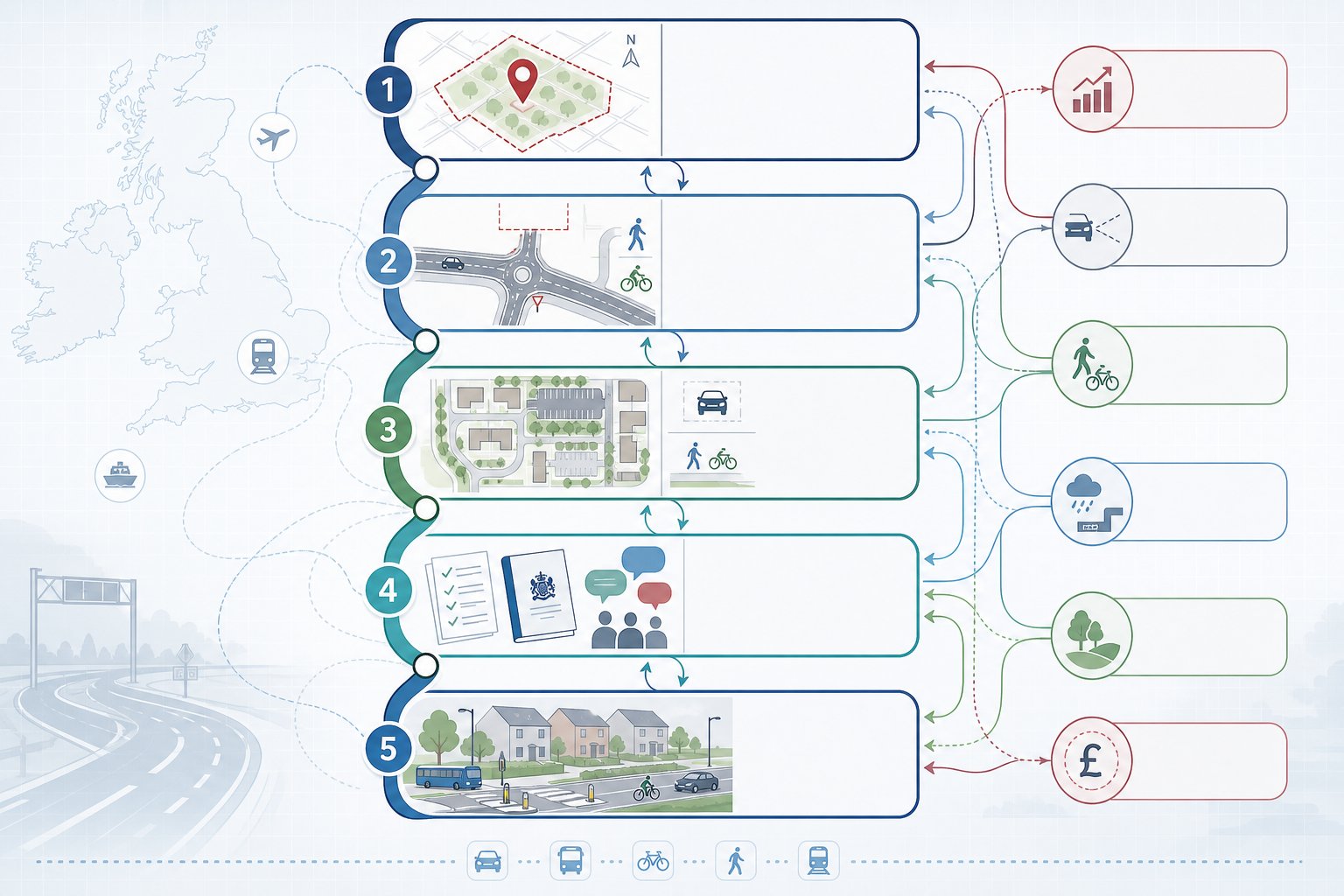
End to end transport planning is the continuous management of transport issues from the first site idea through to post-permission delivery. In practice, that means transport is not treated as a late-stage compliance exercise. It becomes a thread running through the entire planning process.
At concept stage, we test whether a site is fundamentally capable of supporting the proposed use. During appraisal, we examine access options, surrounding highway conditions, sustainable travel opportunities, likely constraints, and policy expectations. As designs evolve, we refine assumptions, shape layouts, develop mitigation, and decide what evidence will be needed to support the application. At submission and during determination, we respond to consultee comments, defend methodology, and help secure conditions or obligations that are proportionate and deliverable.
This matters because transport questions rarely sit in one neat box. A change to unit mix can alter trip generation. A revised red line boundary can affect visibility splays or footway connections. An updated parking strategy can influence landscape, drainage, and viability. End to end work recognises that transport issues are iterative.
For many schemes, the strongest outcomes come when transport advice is embedded early and revisited often. That is the principle behind effective end to end transport planning: one evidence-based process, not a series of disconnected reports.
Why An Integrated Approach Matters For Developers, Councils, And Design Teams
An integrated approach matters because planning decisions are never made on transport data alone. They sit at the intersection of land use, design quality, environmental effects, economic need, public health, safety, and political judgement. If transport planning is isolated from those conversations, friction appears quickly.
For developers, integration reduces risk. Early alignment between transport strategy, masterplanning, drainage, landscape, and commercial objectives helps avoid expensive redesign. It also improves the quality of pre-application discussions because the scheme is presented as a coherent proposition rather than a collection of separate disciplines.
For councils, joined-up transport work helps officers and members understand whether a development supports wider policy goals: sustainable travel, network resilience, town centre vitality, safer streets, and, increasingly, decarbonisation. That is especially important where authorities are balancing growth against local highway pressure or cumulative impacts.
For architects and wider design teams, integrated advice can unlock options rather than simply veto them. Access geometry, street hierarchy, parking placement, cycle provision, and servicing routes all affect the usability and appearance of a scheme. Handled well, transport planning can actively improve design quality.
This is also why many clients now seek Private Sector Transport Planning support earlier. The value is not just in producing a report. It is in coordinating evidence, design, and negotiation so a scheme is robust from multiple angles.
How Transport Planning Fits Into Site Appraisal And Early Feasibility

The biggest gains often happen before a planning application is even drafted. At site appraisal and feasibility stage, transport planning helps us answer a basic but commercially important question: is this site likely to work for the proposed development, and on what terms?
That means looking beyond simple access availability. We need to understand how a site connects to the wider highway network, whether public transport and active travel options are realistic, what local policy will expect, and whether any transport constraints could limit the scale, form, or phasing of development. A site may be technically accessible yet still struggle because junction capacity is tight, sustainable connectivity is weak, or servicing arrangements conflict with neighbouring uses.
Early transport input also improves decision-making around acquisition, option agreements, layout testing, and consultant team assembly. In many cases, it can identify whether a scheme is likely to require a Transport Assessment, a Transport Statement, a Travel Plan, detailed modelling, Road Safety Audit input, or off-site works.
Just as importantly, feasibility-stage advice can highlight opportunities. A nearby bus corridor, a potential walking link, or a revised access strategy may materially strengthen the planning case and influence land value. That is why the best site appraisals are not passive reviews: they are active tests of risk and potential.
Reviewing Site Access, Highway Constraints, And Surrounding Network Conditions
A proper early review starts with the baseline. We assess existing access arrangements, frontage conditions, speed environment, visibility, junction form, carriageway width, footway continuity, cycle links, and proximity to bus and rail services. We also consider traffic conditions on the surrounding network, known pressure points, and whether the local highway authority has existing concerns about congestion, road safety, or rat-running.
Collision data can be especially revealing. A pattern of turning collisions, pedestrian incidents, or speed-related accidents can change the tone of an application very quickly. So can physical limitations such as embankments, retaining walls, mature trees, third-party land, or utility apparatus that make a seemingly simple access alteration more complicated in reality.
We also need to look wider than the site entrance. If the nearest junctions already operate under stress, or if walking routes to local facilities are poor, those issues may shape the scope of future assessment and mitigation. Strategic review at this stage often feeds directly into an Access Strategy Transport approach that the full team can design around.
Identifying Planning Risks, Opportunities, And Likely Transport Requirements
Once the baseline is understood, the next step is to identify what is likely to matter in planning terms. Risks may include inadequate visibility, constrained servicing, limited sustainable mode access, nearby congested junctions, conflict with local parking standards, or policy tensions around car-dependent development. On some sites, flood constraints or heritage sensitivities indirectly affect transport because they restrict where access can be formed or improved.
But opportunity matters too. A development may be able to support mode shift through better walking and cycling links, bus stop upgrades, car club provision, or improved street design. In town centres, the transport strategy may be less about highway capacity and more about servicing windows, pedestrian priority, and public realm balance.
Likely requirements should also be mapped early: scope of assessment, surveys, swept path checks, travel planning obligations, section 278 works, section 106 contributions, or construction logistics considerations. This is where transport advice starts to influence viability and programme. Good early-stage thinking, including Masterplan Transport Inputs: A scheme-wide review, prevents the unpleasant surprise of discovering key requirements when the application is almost ready to go.
Core Technical Assessments Used Across A Project Lifecycle
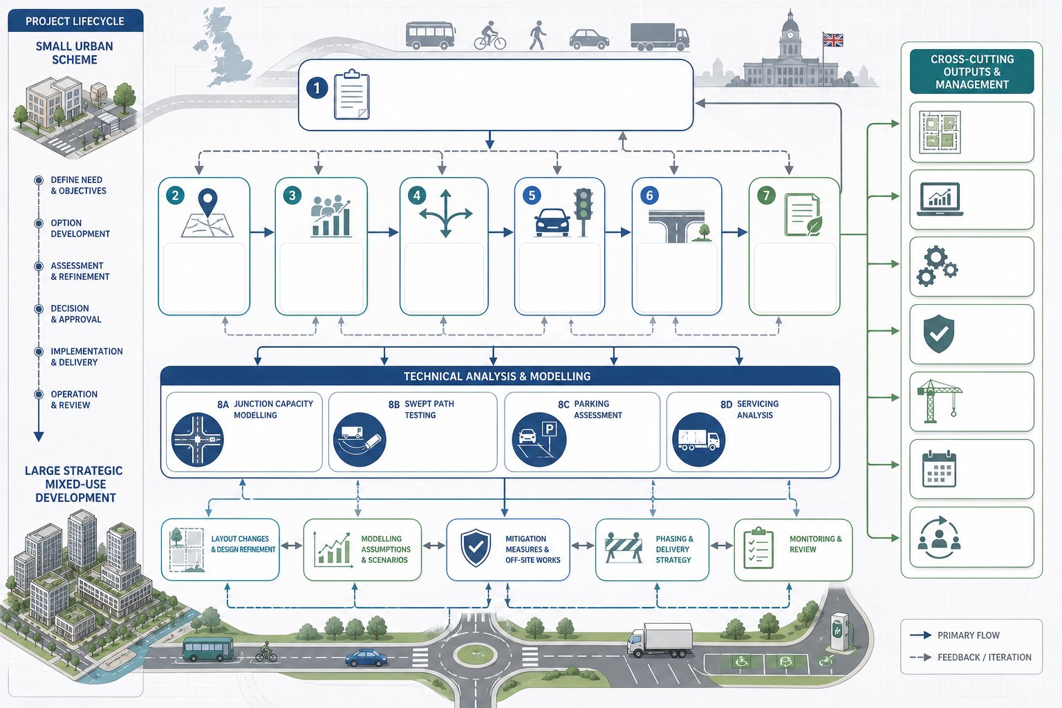
Transport planning across a project lifecycle relies on a set of technical tools, but the right package depends on the scale, use, context, and sensitivity of the site. Not every scheme needs every assessment. The key is to scope proportionately while making sure the evidence is strong enough to withstand scrutiny.
At one end of the spectrum, a modest change of use in a well-connected urban location may only need a concise statement and a clear policy-led access strategy. At the other, a strategic residential or mixed-use development may require staged modelling, junction assessments, travel planning, internal layout testing, servicing analysis, and ongoing negotiation over mitigation and phasing.
The common mistake is to think of these documents as standalone outputs. In reality, they are linked. Trip generation assumptions affect junction modelling. Layout changes affect tracking and parking. Sustainable accessibility evidence informs travel planning commitments. A robust process keeps those components aligned from first draft to final submission.
Transport Assessments, Transport Statements, And Travel Plans
Transport Assessments and Transport Statements are the core planning documents used to explain how a development will affect movement and access. In broad terms, a Transport Statement is used for schemes with more limited impacts, while a Transport Assessment is more detailed and typically supports larger or more sensitive proposals. Local thresholds vary, which is why authority-specific scoping matters.
These documents usually cover existing conditions, relevant policy, accessibility by mode, trip generation, trip distribution, traffic impact, access arrangements, road safety, parking, servicing, and sustainable travel measures. Their job is not simply to present data. They must build a coherent planning argument: that the site is accessible, the impacts are understood, and any effects can be managed acceptably.
Travel Plans sit alongside that work. A good Travel Plan is practical, measurable, and tailored to the occupier profile. It sets out how walking, cycling, public transport, car sharing, and low-emission travel will be encouraged over time. For many councils, that is no longer a peripheral add-on: it is part of the core acceptability case, particularly where Net Zero Transport Planning objectives are embedded in policy. Detailed transport assessment for schemes also need assumptions that remain consistent across every supporting note and drawing.
Junction Capacity, Swept Path, Parking, And Servicing Analysis
Supporting analyses are often where technically credible applications are won or lost. Junction capacity modelling helps us understand how development traffic will interact with the existing network and whether mitigation is needed. Depending on context, that could involve priority junction modelling, roundabout analysis, signal assessments, or wider network testing where cumulative effects are relevant.
Swept path analysis tests whether vehicles can safely and efficiently manoeuvre through access points, internal roads, service yards, and turning heads. It sounds niche. It is not. One poorly resolved refuse or delivery route can trigger redesign, operational objections, or post-permission headaches.
Parking analysis is equally important. We need to consider not just numerical compliance with standards, but also usability, disabled provision, cycle parking quality, electric vehicle charging expectations, visitor demand, and overspill risk. Servicing studies look at how deliveries, refuse, emergency access, and maintenance activity will work in day-to-day conditions.
The best schemes bring these strands together early, often with support from Developer Transport Consultants: teams who understand that operational realism matters as much as technical modelling.
Data Collection, Policy Review, And Evidence-Led Decision Making
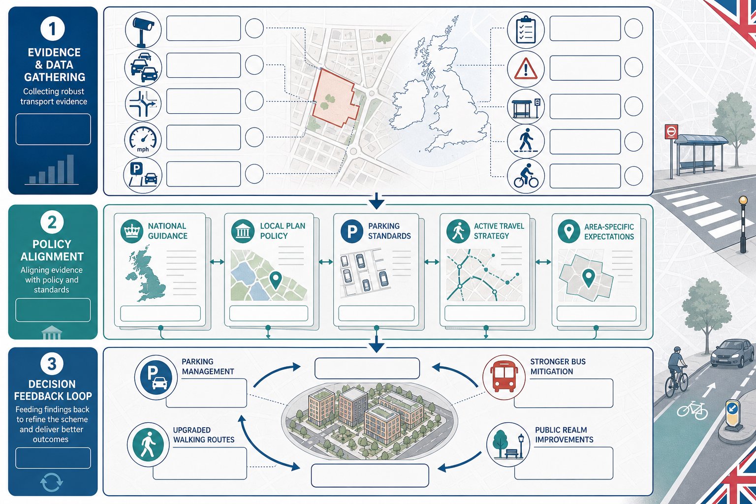
Good transport planning is evidence-led or it is vulnerable. Assertions without reliable data rarely survive consultee review, especially where local concern is strong or the highway authority already has pressure points on its network.
Data collection usually includes traffic counts, queue observations, turning counts, speed surveys, parking beat surveys, site observations, collision analysis, public transport accessibility review, and where relevant, pedestrian and cycle audits. Census data, National Travel Survey context, local trip databases, and operator information may also inform the picture. The aim is not to gather data for the sake of it, but to build a baseline that is current, proportionate, and relevant to the site.
Policy review matters just as much. National policy and guidance set the broad framework, but local plan policies, supplementary planning documents, parking standards, active travel strategies, and area-specific guidance often determine what a council expects to see. A scheme can be technically competent yet still underperform if it does not respond directly to local policy language.
Evidence-led decision making means using that information to shape the proposal, not just justify it afterwards. If surveys show parking stress, that may alter unit mix or visitor management. If bus accessibility is weak, mitigation may need to be more ambitious. If walking links are poor, public realm improvements may become central to the transport case. That feedback loop is what makes end to end transport planning effective rather than merely procedural.
Design Development, Mitigation, And Negotiation With Local Authorities
Once baseline evidence and initial assessment are in place, transport planning moves into a more collaborative phase. This is where technical findings shape design development and where the team begins to negotiate a realistic pathway to acceptability.
Mitigation is not only about adding capacity at a junction. In many schemes, the most effective measures are design-led: better access geometry, safer crossing points, stronger cycle links, clearer internal hierarchy, more efficient servicing, improved bus stop connections, or a parking strategy that supports the intended mode split. Some developments need physical off-site works. Others need behavioural measures, monitoring, or contributions to wider transport improvements.
Negotiation with local authorities works best when it is transparent and evidence based. Highway officers want to understand methodology, assumptions, sensitivity testing, and deliverability. Planning officers want to know how transport aligns with placemaking, sustainability, and policy. Elected members, meanwhile, often focus on local lived experience: school traffic, overspill parking, road safety, and fairness.
This is where experience really shows. A transport team that can explain technical issues clearly, revise proposals without losing strategic coherence, and distinguish between genuine risks and negotiable preferences is invaluable. In our experience, vision led transport thinking tends to produce more resilient outcomes because it connects movement strategy with the kind of place the development is trying to create.
Managing End-To-End Transport Planning Through Submission And Determination
Submission is not the finish line for transport planning. It is the point at which the evidence base is tested by consultees, officers, and often the public. Schemes that have been managed properly up to this stage are usually easier to defend, but they still require active handling.
During determination, we often need to respond to technical comments, clarify assumptions, issue addendum notes, update drawings, or agree wording for planning conditions and obligations. Junction modelling may need sensitivity testing. Travel Plan measures may need stronger monitoring commitments. Access drawings may require small geometric refinements to satisfy detailed highway comments.
Coordination is critical. The transport position must stay consistent with the planning statement, design and access material, drainage strategy, landscape proposals, and legal drafting. Small inconsistencies can create unnecessary doubt and trigger requests for further information.
Programme management matters too. Delays frequently arise not because an issue is fatal, but because responses are slow, evidence is fragmented, or ownership is unclear across the consultant team. Experienced Transport Planning Consultants: What teams add value here by keeping technical threads aligned, anticipating consultee concerns, and helping applicants move from submission to decision with fewer avoidable detours. That matters whether the scheme is a small commercial unit or a complex multi-phase development.
Common Mistakes That Delay Planning Applications And How To Avoid Them
Most transport-related delays are predictable. They happen when teams leave key questions too late, under-scope technical work, or assume one authority will accept the same approach as another.
A common problem is weak baseline evidence. Out-of-date traffic counts, limited site observations, or generic accessibility commentary make it hard to persuade officers that impacts are properly understood. Another is inconsistent assumptions: one trip rate in the Transport Assessment, another in a drainage note, and a third implied by the Design and Access Statement. Even when the differences are accidental, they undermine confidence.
Ignoring local policy is another frequent mistake. Parking standards, cycle provision requirements, Travel Plan thresholds, and active travel expectations can vary significantly between authorities. Early engagement with the highway authority, where appropriate, often saves time because it helps define the likely scope of work and reveals local sensitivities before the design is fixed.
Late transport input can also force unnecessary redesign. Access widths, refuse tracking, emergency vehicle routes, and visibility splays are much cheaper to resolve at concept stage than a week before submission. And sustainable transport should never be treated as decorative wording. Councils increasingly expect meaningful provision, particularly on larger schemes or where decarbonisation goals are explicit.
The practical fix is simple, even if the execution takes discipline: start early, scope carefully, gather robust data, align the consultant team, and keep the transport narrative consistent from feasibility through determination. With that structure in place, applications tend to move faster and withstand scrutiny better.
Conclusion
End to end transport planning works because it treats transport as a continuous part of development strategy rather than a late report-writing exercise. From first appraisal through design, assessment, mitigation, submission, and determination, it creates a single evidence-based thread that helps teams make better decisions.
For developers, that means less avoidable risk and fewer costly surprises. For councils, it supports policy-led, defensible decisions. For architects, planners, lawyers, surveyors, and builders, it gives the project a clearer route through the planning process.
In 2026, the strongest planning applications are rarely the ones with the most paperwork. They are the ones where transport thinking has been embedded early, coordinated properly, and translated into a scheme that is accessible, safe, functional, and realistic to deliver. That is the real value of end to end transport planning: not more process for its own sake, but smarter planning from start to finish.
Frequently Asked Questions about End to End Transport Planning
What does end to end transport planning involve in the UK planning process?
End to end transport planning is the continuous management of transport issues from first site consideration through appraisal, design, application, and post-permission delivery, ensuring transport is integrated at every stage rather than treated as a late compliance exercise.
Why is an integrated transport planning approach important for developers and councils?
An integrated approach aligns land use, design, and transport modes, reducing risk for developers through early coordination, helping councils assess policy compliance, and enabling design teams to improve mobility, equity, and safety in development schemes.
How does end to end transport planning support site appraisal and feasibility?
Transport planning at site appraisal stage reviews access, network conditions, public transport, and sustainable travel opportunities to identify constraints and opportunities that influence development scale, mix, and layout before application submission.
What are common technical assessments used across a transport planning project?
Key technical inputs include Transport Assessments or Statements estimating traffic impacts, Travel Plans promoting sustainable travel, alongside junction capacity modelling, swept path analysis, parking and servicing studies, all coordinated to create consistent and robust evidence.
How can end to end transport planning help avoid delays in planning applications?
By starting early, gathering solid baseline data, following local policies, involving authorities promptly, and maintaining consistent trip assumptions, end to end planning prevents common issues like under-scoped assessments or late redesigns that often cause delays.
What role do Transport Planning Consultants play in end to end transport planning?
Transport Planning Consultants coordinate evidence, design, and negotiation throughout a project to keep technical aspects aligned, anticipate authority concerns, and support applicants in navigating the process, enhancing the likelihood of planning success.