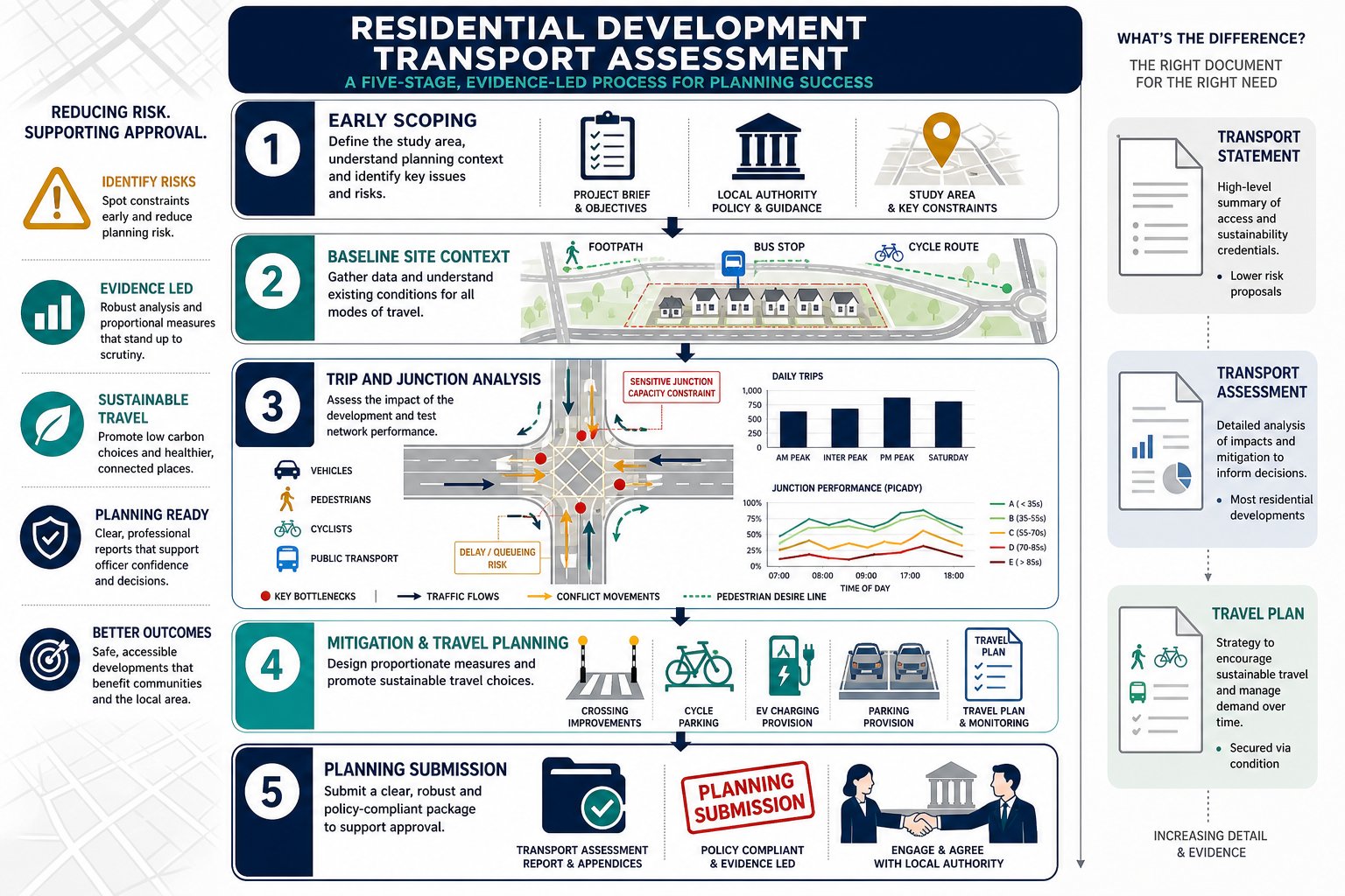
Planning risk on a housing scheme rarely announces itself with a dramatic headline. More often, it turns up as a late highways objection, a request for fresh traffic counts, or a disagreement over whether the site should have been supported by a full assessment rather than a shorter statement. By that stage, programme time has already gone.
That is why a residential development transport assessment matters so much. Done properly, it is not just a technical planning document. It is the evidence base that shows a proposed scheme can be safely accessed, can operate acceptably on the surrounding network, and can support walking, cycling and public transport in line with UK planning policy.
For architects, planners, developers, solicitors, surveyors, builders and local authorities, the challenge is usually not understanding that transport matters. It is knowing what level of assessment is proportionate, what data the authority will expect, and how to avoid the predictable issues that stall decisions.
In this guide, we set out the practical side of a residential development transport assessment in 2026: when it is required, what it should cover, how development type changes the scope, and how to build a robust submission that stands up to scrutiny. Our perspective is shaped by more than 30 years of transport planning experience and by the reality that every local authority applies policy a little differently. That local nuance, honestly, is where many applications are won or lost.
What A Residential Development Transport Assessment Is And When It Is Required
A residential development transport assessment is a detailed appraisal of how a proposed housing scheme will affect movement to and from a site across all relevant modes. In practice, that means we assess existing highway and sustainable transport conditions, estimate the trips the development will generate, test the likely effect on junctions and links, review safety, and identify any mitigation needed to make the proposal acceptable in planning terms.
For a planning authority, the purpose is straightforward: can the site be accessed safely, can the network accommodate the additional demand, and does the scheme support policy objectives around sustainable travel rather than simply adding car trips with no credible alternative?
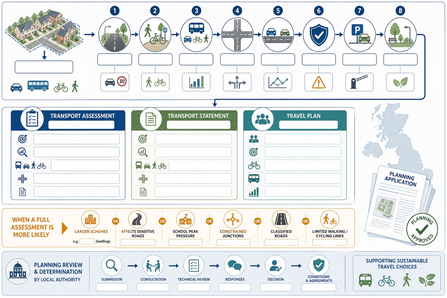
A full TA is usually required for larger residential schemes, higher-impact sites, or locations with known sensitivity such as congestion, poor road safety records, constrained access, school peak pressure, or limited active travel connections. As a rule of thumb, many authorities look more closely once proposals move beyond around 50 dwellings, though that is not a national hard line. Some sites below that figure still need a TA because the local road network is fragile or politically sensitive.
The key point is proportionality. A well-scoped TA should be thorough, but not bloated. In our experience, one of the most useful starting points is agreeing the likely level of work early, especially where the development sits in that grey area between minor and major impact. Broader guidance on a transport assessment for developments can help frame that discussion before scope is fixed.
How A Transport Assessment Differs From A Transport Statement And Travel Plan
The terms are often used loosely, but they are not interchangeable.
A Transport Assessment is the full technical document. It is evidence-heavy, quantitative, and usually includes survey data, trip-rate analysis, distribution and assignment, junction modelling where needed, road safety review, parking analysis and mitigation proposals. It is for developments where transport effects may be material.
A Transport Statement is lighter-touch. It still needs to be competent and site-specific, but it is generally used where impacts are expected to be limited. It tends to describe conditions and likely effects with less modelling and fewer detailed forecasts.
A Travel Plan is different again. It is not the impact assessment itself but the strategy for influencing travel behaviour once the development is occupied. That can include cycle parking, travel information packs, bus incentives, car club provision, welcome vouchers, monitoring and targets for mode share.
The cleanest way to think about it is this: the TA or TS explains the transport impact: the Travel Plan explains how we will manage and improve travel choices over time. On some schemes, all three concepts appear together, but as separate functions.
Typical Planning Thresholds And Why Local Authority Requirements Matter
There is no single UK threshold that decides every case. National policy and guidance support a proportionate approach, but local planning authorities and highway authorities usually publish their own validation requirements or transport guidance notes.
Typical triggers include dwelling numbers, peak-hour trip generation, percentage impact on nearby junctions, access onto classified roads, proximity to schools, town centres or constrained junctions, and whether the site sits near the strategic road network. A common local rule is that a TA may be required above 50 dwellings, or where development traffic could add around 5% to 10% to flows at a sensitive location. But “may” is doing a lot of work there.
We have seen modest schemes require substantial analysis because they front onto fast roads, rely on substandard visibility, or sit in a village where a small traffic change is highly contested. Equally, larger urban infill sites in highly accessible locations can sometimes be scoped efficiently if the evidence is clear. That is why early dialogue with the authority matters more than chasing generic thresholds.
For developers, this is one reason concise, locally tailored Property Development Transport advice can save time: the right answer depends on the site, the authority, and the actual transport questions that need proving.
What A Residential Transport Assessment Should Cover
A strong residential TA is not a box-ticking exercise. It should tell a coherent story from site context through to impact and mitigation, using transparent evidence and recognised methods. At minimum, we would expect it to explain the development proposals, relevant planning and transport policy, the baseline conditions, the likely travel demand, and whether any changes to access, infrastructure or management are necessary.
The best assessments also avoid a common trap: presenting technical outputs without explaining why they matter. A junction model is only useful if it is tied back to network function, user experience, safety and policy objectives. Authorities increasingly expect that broader narrative, particularly where active travel and decarbonisation are concerned.
Site Access, Highway Conditions, And Sustainable Travel Context
This part of the assessment establishes whether the site is fundamentally in the right place and whether people can realistically reach it safely.
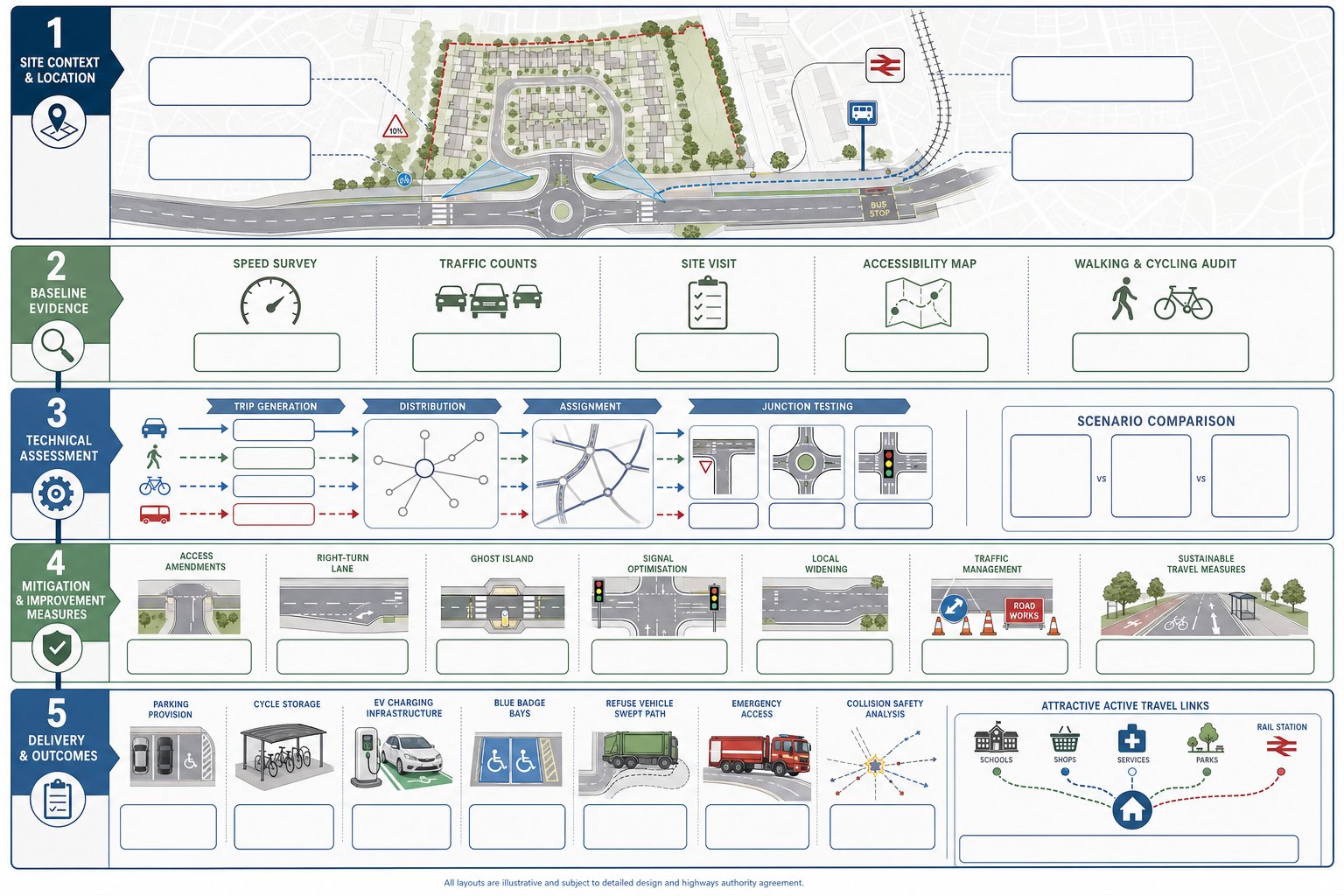
We would normally review the surrounding highway network, existing junction forms, carriageway widths, speed environment, visibility splays, footway provision, crossing opportunities, cycle links, bus stops, rail access where relevant, and any physical constraints such as walls, trees, gradients or third-party land. A site access drawing is often central here, because planning officers and highway engineers want to know quite early whether the access can work in engineering terms.
But a modern residential development transport assessment should not stop at vehicle access. It should assess how residents will walk to local schools, shops and services, whether cycle routes are direct and legible, and whether public transport is a practical option rather than a policy aspiration. That is where a vision led transport approach can strengthen the case, especially on urban and edge-of-centre schemes where mode choice is a live issue.
Baseline evidence may include speed surveys, traffic counts, site visits, accessibility mapping and an audit of walking and cycling routes. If this section is weak, the rest of the TA tends to wobble.
Trip Generation, Distribution, Assignment, And Junction Impact
This is usually the technical core of the document.
Trip generation estimates how many vehicle, pedestrian, cycle and public transport trips the development is likely to create, often using TRICS data, census evidence, local surveys and reasoned adjustments for site context. The point is not to produce a single abstract number: it is to demonstrate a defensible forecast for relevant peak periods.
Distribution then considers where those trips will come from and go to. Assignment loads those trips onto the surrounding network. On a smaller site, that may be done with turning proportions and professional judgement. On larger or more sensitive schemes, we may need more detailed network modelling.
Junction impact testing compares baseline and future-year conditions, usually in scenarios such as: existing year, opening year without development, opening year with development, and future assessment year with development. Depending on the junction type, modelling might use priority, roundabout or signal software. The authority will expect agreed growth assumptions, realistic committed development allowances and clear explanation of results.
Where the impact is notable, mitigation could involve access amendments, ghost islands, right-turn lanes, signal optimisation, localised widening, traffic management or sustainable travel measures that reduce car dependency. On some projects, the line between a TA and a wider traffic impact assessment becomes quite thin, particularly if cumulative effects are under scrutiny.
Parking, Servicing, Road Safety, And Active Travel Considerations
These topics can look secondary on paper. In reality, they are often what determines whether the authority is comfortable with the scheme.
Parking needs to align with local standards, but numbers alone are not enough. We need to show the strategy is workable for residents and visitors, supports the character and density of the site, and avoids overspill risk on surrounding streets. Cycle parking, EV charging and blue badge provision now carry more weight than they did even a few years ago. For schemes where layout efficiency and compliance are tight, a well-evidenced Parking Strategy For developments can make the difference between policy conflict and a balanced planning judgment.
Servicing also matters. Refuse collection, deliveries, and emergency access must be accommodated safely without awkward reversing movements or blocked routes.
Road safety analysis should consider personal injury collision records, local patterns, vulnerable users, crossing demand, visibility, speed environment and any design features that increase conflict. And active travel should not be tacked on at the end. Authorities increasingly want to see direct, safe and attractive walking and cycling routes integrated into the layout and linked to off-site destinations. If the TA treats active travel as a paragraph rather than a design principle, that weakness tends to show.
How Residential Development Type And Scale Affect The Assessment
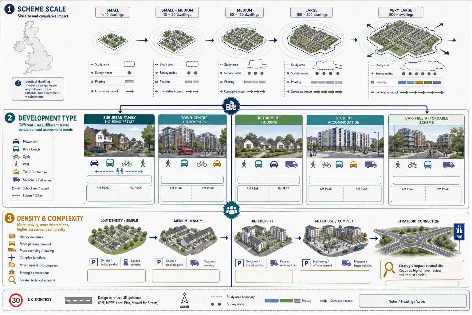
Not all housing generates the same transport effects, and a credible TA has to reflect that. A suburban estate of 120 family houses, a town-centre apartment scheme, a retirement development, a student block and a car-free affordable housing proposal may all have the same dwelling count while producing very different travel patterns.
Scale is the obvious variable. Larger schemes usually trigger broader study areas, more survey work, more future-year testing and greater attention to cumulative impact. They may also require phased assessment, framework travel planning, multiple access points or mitigation that extends beyond the site frontage.
Type is just as important. Family housing often has sharper school-run and commuter peaks. Flatted schemes in accessible centres may show lower car ownership and a stronger case for mode shift. Older persons’ accommodation can produce lower peak-hour demand but different servicing and taxi patterns. Student housing may have lower car use but higher seasonal move-in activity and heavy walking and cycling demand.
Density changes things too. High-density schemes can place pressure on parking, servicing and local street function even where overall trip rates are moderate. Mixed-use elements, if included, can alter internalisation assumptions and peak spreading. And if the site connects to the strategic road network or affects trunk roads, National Highways may need to be involved, which usually raises the technical bar.
This is why template reporting rarely works well. A proportionate assessment for one residential form can be wholly inadequate for another. In more complex cases, a broader Private Sector Transport Planning strategy helps align land use, design and transport evidence before the application reaches the validation desk.
The Step-By-Step Process From Scoping To Submission
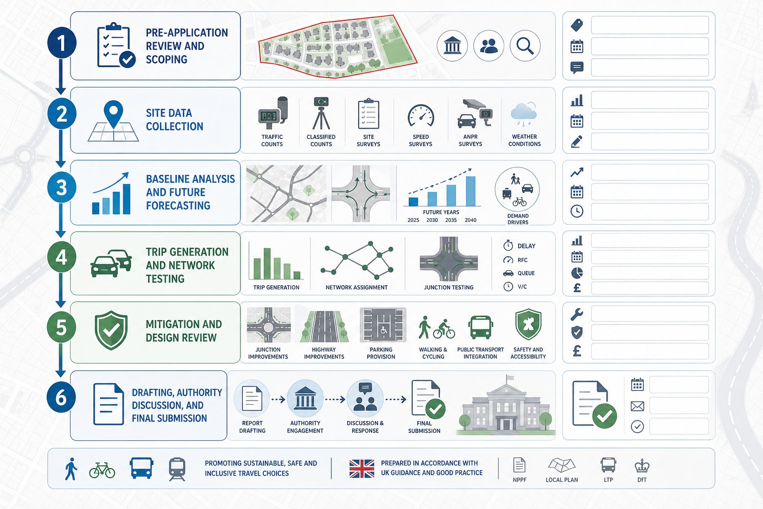
A good TA is usually the result of process discipline rather than last-minute technical heroics. The sequence matters.
We start with pre-application review and scoping. That means understanding the proposed development, identifying likely transport issues, checking local validation requirements, and agreeing with the local planning authority or highway authority what should be assessed. Study area, survey scope, assessment years, committed development, modelling tools and whether a Travel Plan is required should be discussed as early as possible.
Then comes data collection. Depending on the site, that may include automatic traffic counts, turning counts, queue observations, speed surveys, parking beat surveys, accessibility audits, collision records and public transport information. Timing matters: outdated counts, school holiday surveys or poor weather anomalies can undermine the submission.
Once the data is in place, we analyse the baseline and prepare future-year forecasts. We then calculate trip generation, agree or justify trip rates, distribute trips, assign them to the network and test the effect at relevant junctions. In parallel, we review access design, active travel links, parking, servicing and safety.
Mitigation is developed from the evidence, not reverse-engineered from a preferred design. After that, the TA and any Travel Plan are drafted, checked and ideally discussed informally with the authority before final submission.
Where local context is especially sensitive, access to an experienced Traffic Engineer In practice can smooth the process because the technical work and authority dialogue need to stay tightly aligned from day one.
Common Issues That Delay Planning Applications
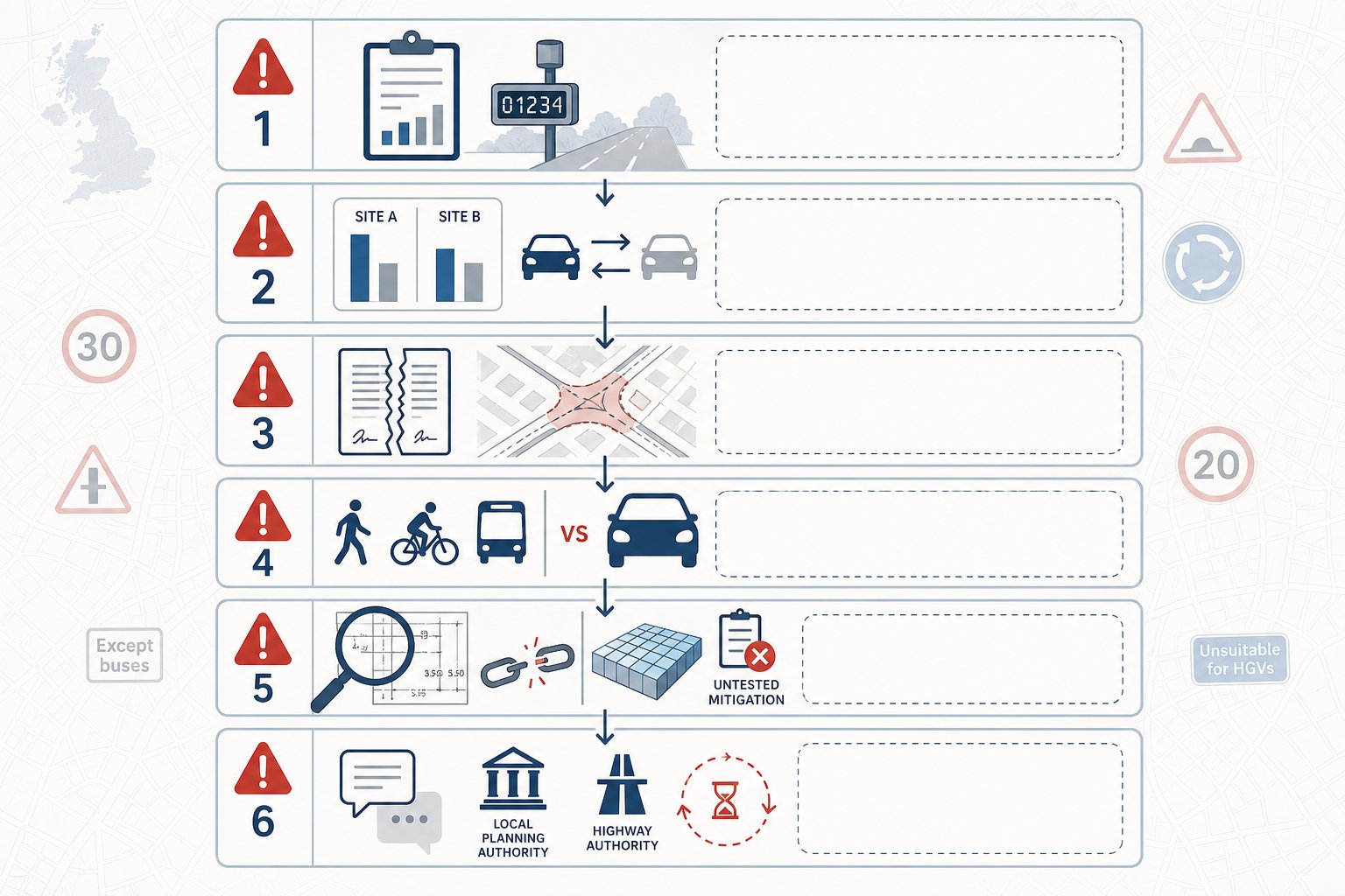
Most transport-related delays are predictable. They happen not because the subject is unusually complex, but because key questions were left unresolved until too late.
One recurring problem is inadequate baseline data. Counts may be out of date, undertaken in unrepresentative conditions, or too limited for the scale of the proposal. Another is disagreement over trip rates. If the applicant relies on poorly matched TRICS sites, excludes inconvenient comparables, or applies optimistic reductions without local justification, objections follow quickly.
Scope disputes are another classic delay. Perhaps the applicant assumed a Transport Statement would be enough, while the authority expected a full TA. Or a junction left out of the original study area becomes contentious after consultation. Once those disagreements surface at application stage, programme slippage is almost guaranteed.
Sustainable transport is also a frequent weak point. Authorities increasingly scrutinise walking and cycling routes, bus accessibility and travel plan measures. A car-led document with only token references to mode shift can feel outdated in 2026.
Then there are technical presentation issues: unclear diagrams, unexplained assumptions, modelling that cannot be audited, and mitigation that is mentioned but not tested. Sometimes the work is broadly sound, but the evidence chain is not visible enough for the reviewing officer to be comfortable.
A final, very human issue: comments from the highway authority are received, partially answered, and then allowed to drift. Keeping responses structured, timely and genuinely collaborative matters. On schemes with community sensitivity, early thinking around public consultation transport can also reduce the chances of transport concerns hardening into formal planning resistance.
How To Prepare A Strong Evidence Base And Work With The Local Authority
The strongest submissions tend to share the same characteristics: they are transparent, proportionate, policy-aware and easy to audit.
That starts with evidence. We should be clear about what surveys were undertaken, when, why they are representative, what databases were used, how forecast assumptions were chosen, and where professional judgement has been applied. If there is uncertainty, it is better to explain it and test sensitivity than to bury it. Reviewers are far more likely to trust a document that shows its workings.
Methodology matters too. Recognised industry tools and accepted modelling approaches should be used wherever possible, and any departures need a rational explanation. The TA should also align with national planning policy, local plan transport policies, parking standards, active travel priorities and climate-related objectives. That policy alignment is no longer a decorative chapter: it often shapes the planning balance.
Working effectively with the authority is less about persuasion than about reducing surprises. Early engagement can confirm whether the site needs a TA or TS, what the study area should be, which junctions need modelling, whether a Travel Plan is expected, and how sustainable transport should be evidenced. During preparation, short and focused communication often works better than long defensive letters.
In our experience, the most productive submissions are those that treat the local highway authority as a technical stakeholder to work with, not an obstacle to outmanoeuvre. When the authority can see that the applicant has understood local concerns, reflected them in the scope, and proposed realistic mitigation, the tone of review usually changes. That does not guarantee support, of course. But it does move the discussion onto the quality of the solution rather than the adequacy of the assignments.
Conclusion
A residential development transport assessment is eventually about proof. It shows, with credible evidence, that a housing proposal can function safely, fit within its transport context and support the kind of travel behaviour planning policy now expects.
For planning teams, the practical lesson is simple: scope early, use robust data, match the level of analysis to the real impact of the scheme, and do not treat walking, cycling, public transport and parking as afterthoughts. The strongest TAs are rarely the longest. They are the ones that answer the authority’s actual questions clearly and without hand-waving.
In 2026, that means combining sound technical analysis with local policy awareness and realistic mitigation. When we get those elements right, a TA becomes more than a validation requirement. It becomes one of the clearest tools available for reducing planning risk and moving a residential application towards consent with fewer surprises along the way.
Residential Development Transport Assessment FAQs
What is a residential development transport assessment and when is it needed?
A residential development transport assessment (TA) evaluates how a proposed housing scheme affects transport modes and the local network, determining if access is safe and sustainable. It is usually required for larger schemes (commonly over 50 dwellings) or sites with sensitive local conditions.
How does a Transport Assessment differ from a Transport Statement and a Travel Plan?
A Transport Assessment is a comprehensive, data-driven evaluation for significant developments. A Transport Statement is a lighter, qualitative review for minor impacts. A Travel Plan is a separate strategy to manage residents’ travel behaviour, promoting sustainable options after occupation.
What key factors should be covered in a residential transport assessment?
A thorough residential TA should cover site access, highway conditions, baseline traffic data, trip generation and assignment, junction impact, parking and servicing arrangements, road safety, and sustainable travel opportunities including walking and cycling routes.
How do the type and scale of a residential development affect the transport assessment?
Different housing types (family homes, apartments, elderly or student housing) and scale influence trip patterns, peak times, and modal shares. Larger or higher-density schemes require broader study areas, more detailed modelling, and tailored mitigation measures.
What common issues can delay planning approval related to transport assessments?
Delays often stem from inadequate or outdated data, disputes over trip rates, insufficient assessment of sustainable travel, poor junction modelling, late scope agreement, and failure to address highway authority comments promptly.
How can developers build a strong evidence base and work effectively with local authorities?
Developers should use robust, transparent data with recognised methods, align the TA with national and local policies, and engage early and collaboratively with local planning and highway authorities to agree scope and mitigation, reducing surprises and facilitating smoother approvals.