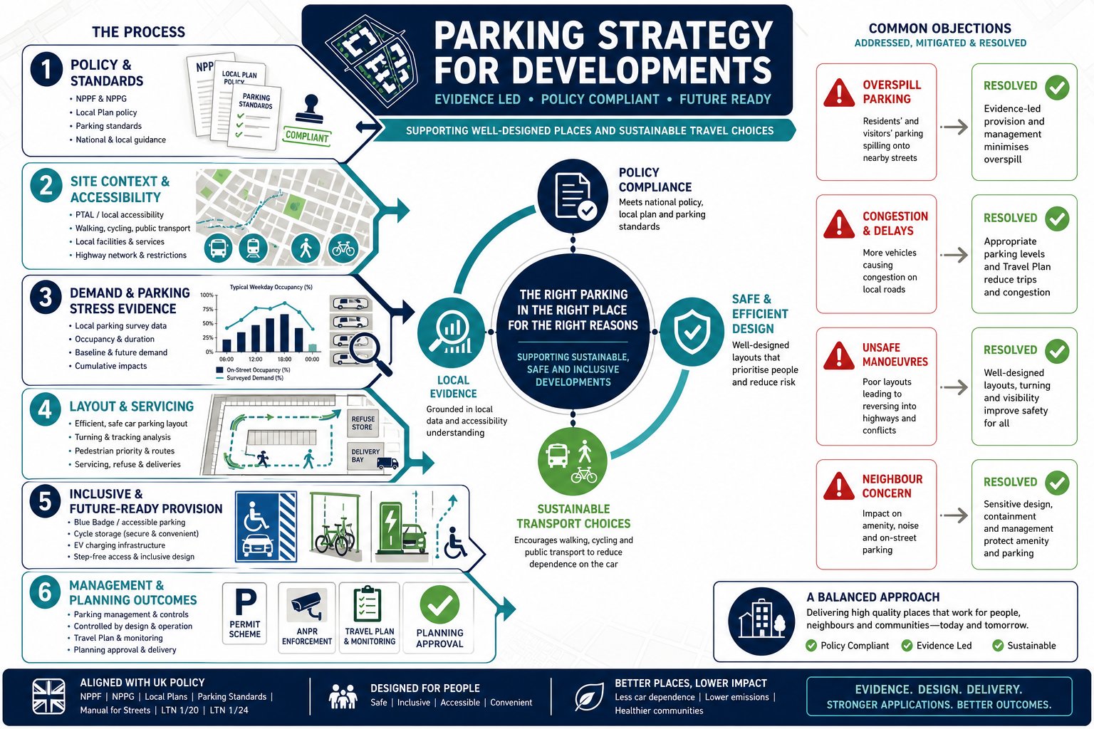
A good parking strategy can rescue a planning application from the kind of objection that keeps teams stuck in revisions for months. A weak one does the opposite. In practice, parking is rarely just about counting bays. It sits right at the overlap of planning policy, highway safety, design quality, accessibility, viability and neighbour concern. Get that balance wrong, and even a well-designed scheme can start to look poorly considered.
In 2026, that balance is under even more scrutiny. Local authorities are expecting clearer evidence, more policy-led justification, and a stronger explanation of how car parking sits alongside active travel, public transport access, Blue Badge provision, cycle parking and electric vehicle charging. At the same time, developers and design teams still need layouts that are buildable, commercially realistic and workable for real users.
That is exactly where a robust parking strategy for developments matters. We use it to show not only how much parking is proposed, but why that level is appropriate, how it will operate, and why it will not create unacceptable effects on the surrounding network. For architects, planners, surveyors, developers and councils alike, the strongest strategies are the ones that combine policy compliance with grounded local evidence.
This article breaks down what that looks like in practice, from standards and surveys through to layout design, management controls and the common planning objections that tend to surface when the evidence base is too thin.
What A Parking Strategy Needs To Achieve In A Planning Application
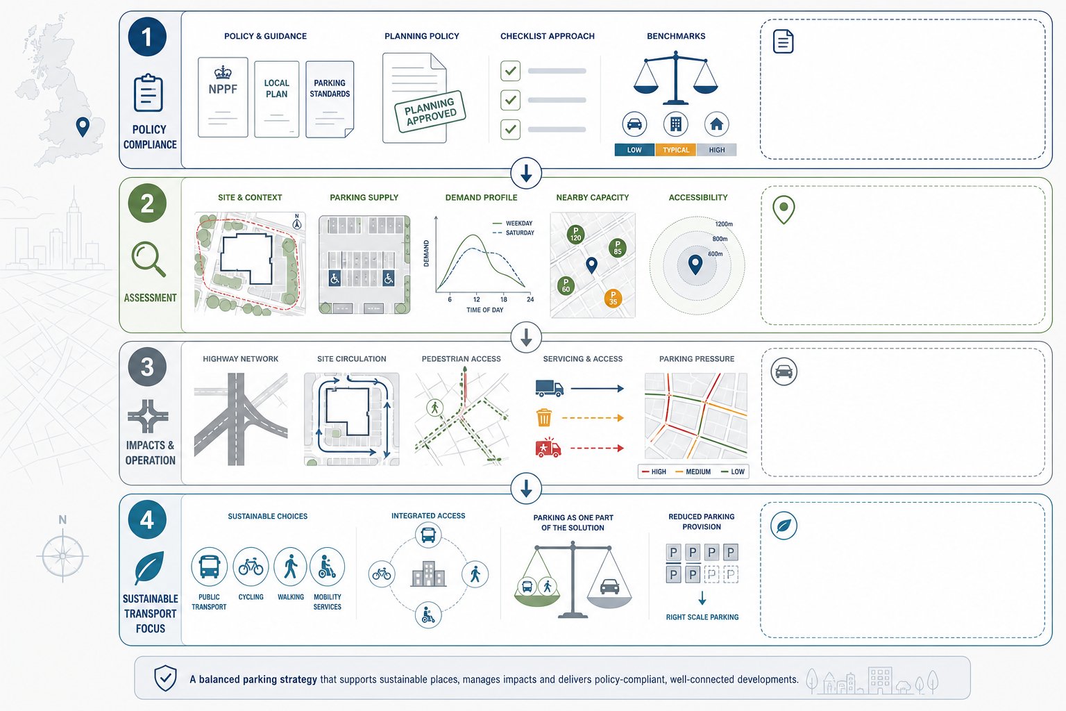
A parking strategy in a planning submission has to do more than state a number of spaces. Its real job is to justify that provision against policy, site reality and likely user behaviour.
At a minimum, we need to demonstrate compliance with the National Planning Policy Framework, the relevant Local Plan, parking standards, design guides and any supplementary planning documents. Some authorities apply maximum standards, some use ranges, and some allow a more discretionary judgement based on accessibility and context. Either way, the strategy has to show that the proposal has been assessed against the right benchmarks.
It also needs to address impact. Planning officers and highway authorities will want confidence that the scheme will not create severe residual impacts on road safety, circulation or local parking stress. That usually means explaining how demand has been calculated, what spare capacity exists nearby, whether overspill is likely, and how servicing, refuse, emergency access and pedestrian movement all fit together.
Then there is the wider planning picture. A credible parking strategy should support sustainable travel rather than undermine it. Lower provision may be justified in accessible urban locations, but only where that conclusion is backed by evidence and practical mitigation. In that sense, parking is never a standalone topic: it is part of the transport story that sits alongside trip generation, accessibility and travel planning.
How Parking Standards, Local Policy, And Site Context Shape Provision
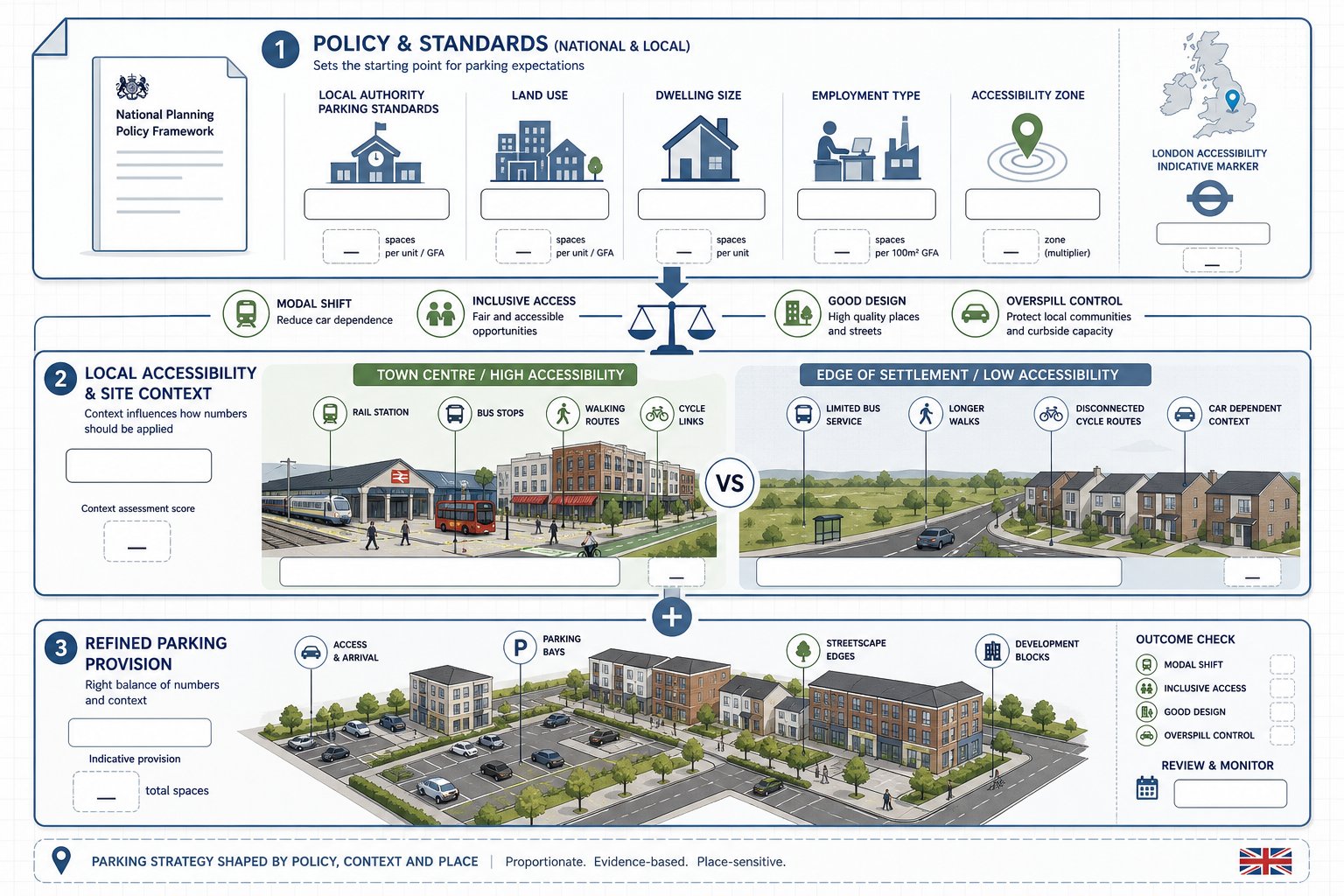
Parking provision starts with policy, but it should not end there. Most local authorities publish standards linked to land use, zone, dwelling size, employment type or accessibility. Those standards often set the first frame for discussion, yet the final answer depends heavily on site context.
For example, a town-centre scheme close to rail services, frequent buses and walkable daily amenities may support materially lower car parking than an edge-of-settlement site with limited alternatives to driving. In London, PTAL scores often shape that judgement. Elsewhere, we may need a more qualitative accessibility review covering service frequency, walking routes, cycle connections and the practical attractiveness of non-car modes.
Local policy can also point in different directions at once. One policy may encourage restraint in car parking to support modal shift, while another emphasises inclusive access, good design and avoidance of overspill onto surrounding streets. The strategy hence needs to reconcile those aims rather than cherry-pick the most convenient clause.
That is why we usually read parking standards together with design policies, transport policies and place-specific guidance. On more complex schemes, the wider mixed use masterplan can be just as important as the numerical standard, because movement, access and parking are often solved together rather than separately.
The strongest strategies show how the numbers arise from policy, then explain how local conditions justify refinement.
Understanding The Development Type, End Users, And Trip Patterns
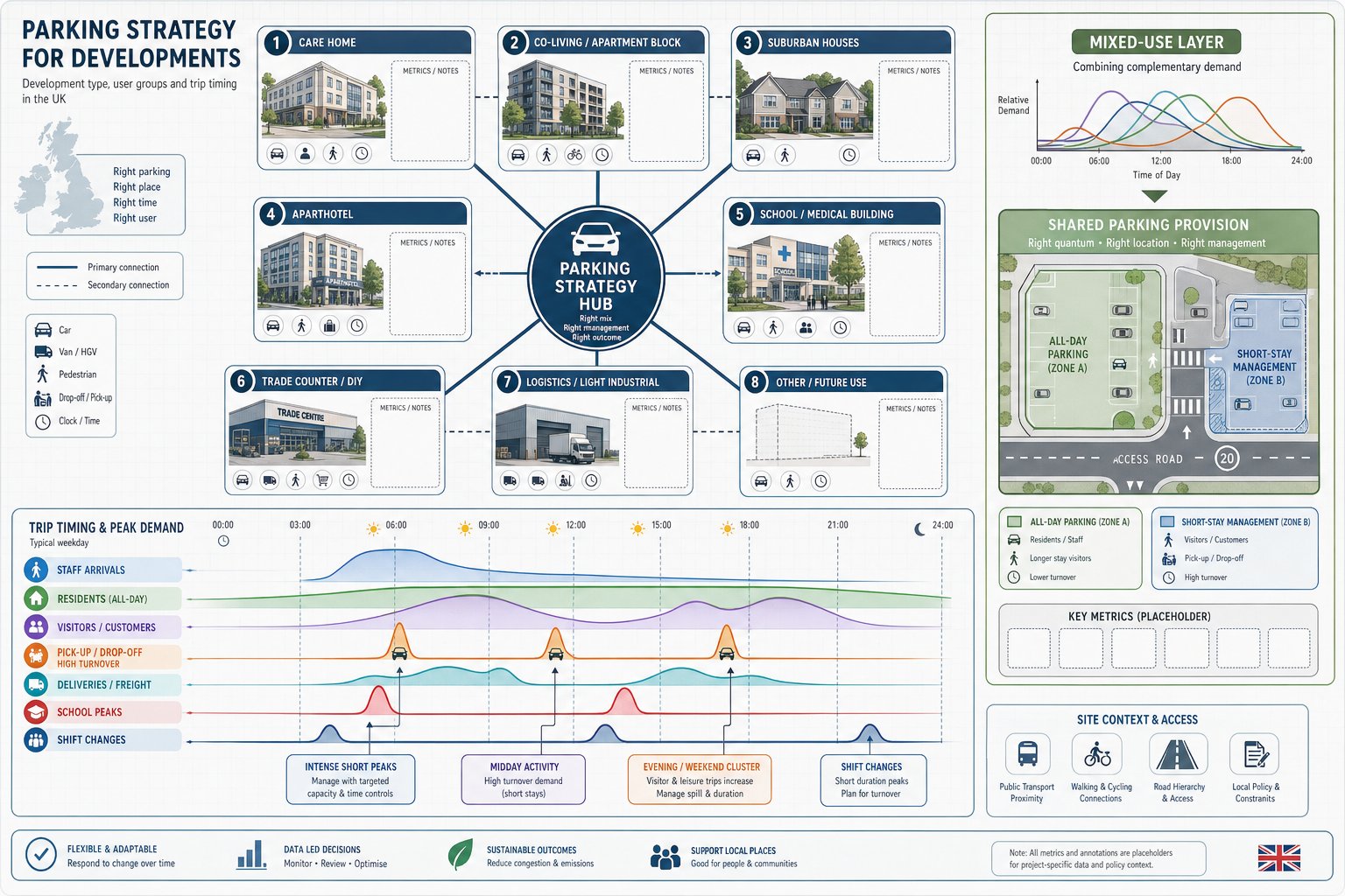
Different developments create different parking pressures, and that sounds obvious until a generic standard gets applied to a non-generic scheme. A care facility, co-living block, suburban family housing, urban aparthotel, trade counter and last-mile logistics unit all behave differently. If we do not understand who the users are and when they arrive, the parking strategy will be built on the wrong assumptions.
We typically look at the use class, expected occupancy, staffing levels, visitor activity, likely car ownership and the timing of arrivals and departures. Shift-based uses matter here. A site with overlapping shift changes can produce short but intense parking peaks. So can schools, medical uses and some industrial occupiers. Residential schemes raise a different set of questions: household size, tenure, unit mix, likely multi-car ownership, and whether visitor demand clusters at evenings and weekends.
Trip patterns matter just as much as parked demand. A development with high turnover may need careful pick-up, drop-off or short-stay management even if its all-day parking demand is modest. Mixed-use schemes add another layer, because demand may peak at different times across uses, creating potential for shared provision if the evidence is robust.
This is where broad transport planning judgement becomes essential. A scheme that looks acceptable in spreadsheet form can still fail in operation if user patterns have been oversimplified. In our experience, early Property Development Transport Advice: often prevents that problem by aligning likely parking behaviour with the site layout and planning narrative from the outset.
Assessing Existing Conditions And Local Parking Stress
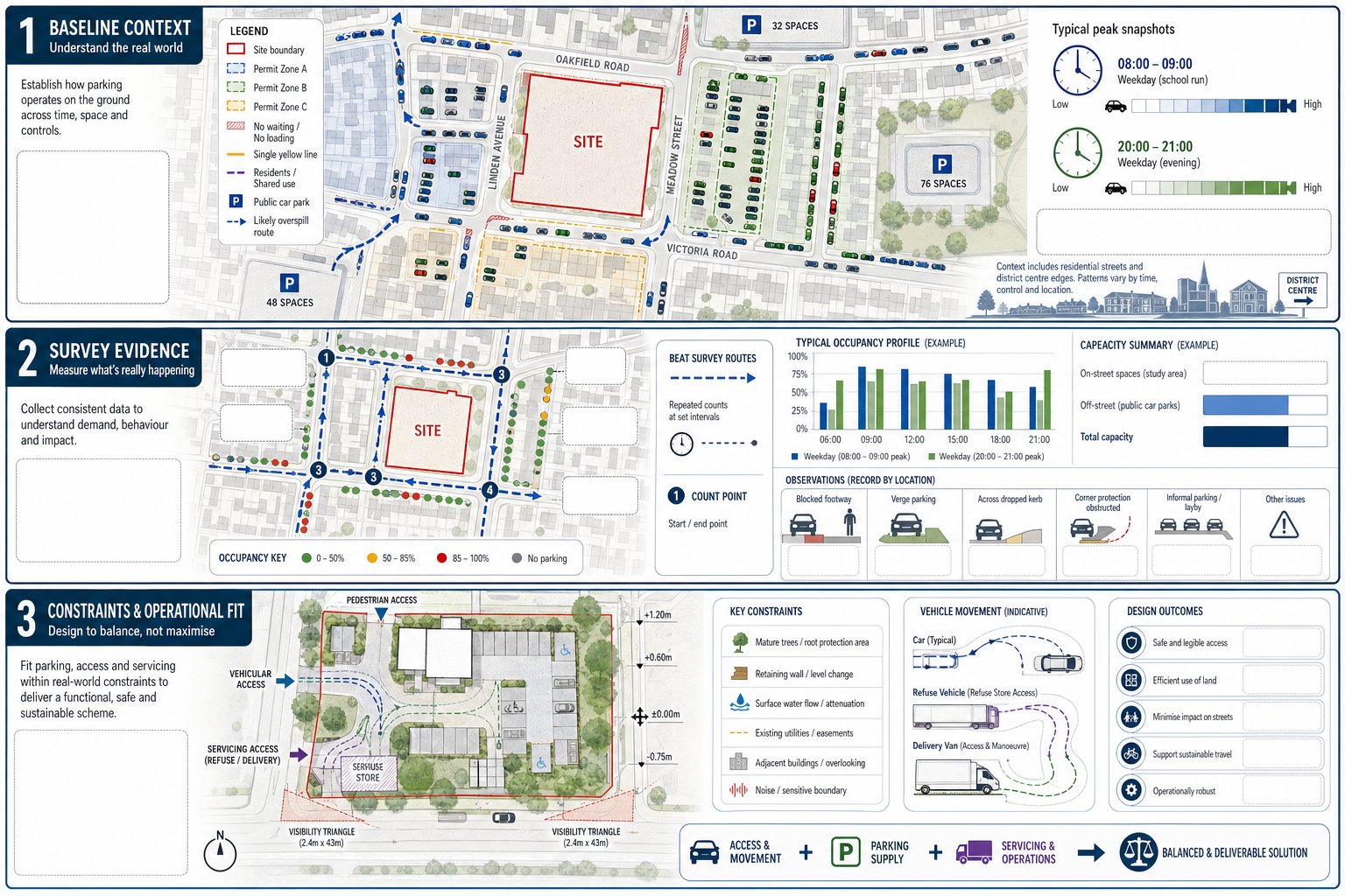
Before we can justify proposed parking, we need to understand the baseline. That means looking beyond the red line boundary and asking a simple but often contentious question: what is already happening on the surrounding streets and in nearby car parks?
A proper baseline review should identify parking controls, permit zones, waiting restrictions, public car parks, informal parking behaviour and the roads most likely to absorb overspill if the development underprovides. We also need to know when stress occurs. A quiet street at 11am on a Tuesday may be effectively full at 11pm, or vice versa. Context matters.
Local parking stress is especially important where neighbours fear that a scheme will displace demand into already pressured residential streets. If we can quantify occupancy and spare capacity at relevant times, that discussion becomes evidence-led rather than speculative. If we cannot, objections tend to gain traction.
Existing conditions also tell us something about user behaviour. High on-street occupancy near stations, schools, district centres or employment clusters may point to broader local demand drivers that the development needs to respect. Equally, low observed occupancy can support a more nuanced case where policy standards appear conservative.
The baseline stage is not glamorous, but it is often where a parking strategy becomes credible. Without it, the rest of the analysis is too detached from the real world.
Parking Surveys, Beat Surveys, And Site Observations
Parking surveys turn local discussion into measurable evidence. In UK planning work, beat surveys or accumulation surveys are commonly used to record parked vehicles at set intervals across defined streets and car parks. Done properly, they help us identify peak occupancy, duration patterns and the amount of practical spare capacity available.
Survey design matters. We need to select streets that are genuinely relevant to potential overspill, use time periods that reflect the proposed land use, and avoid relying on a single convenient snapshot. Residential schemes often need evening and overnight data: retail or employment proposals may need weekday daytime coverage: leisure uses can require later observations.
Site observations add the detail that raw counts miss. We note obstructive parking, corner protection issues, informal verge parking, blocked footways and whether legal capacity is meaningfully usable in practice. A street might look as if it has spare space on paper, but poor geometry, dropped kerbs or servicing activity may reduce what drivers will actually use.
Transparent methodology is essential. Authorities are far more likely to accept survey evidence when the study area, timing and assumptions are clearly set out and proportionate to the scale of the application.
Constraints Such As Highway Layout, Access, And Servicing
Not all parking questions are about demand. Sometimes the constraint is physical. Highway layout, visibility, carriageway width, gradients, retaining structures, trees, servicing routes and refuse collection requirements can all limit what can be delivered safely.
Access design often becomes the pivot point. A scheme may technically fit more spaces, but only by creating awkward manoeuvres, poor pedestrian routes or conflict with delivery vehicles. That is rarely worth it. Likewise, basement or podium parking can appear efficient until ramp gradients, headroom, fire access or structural grids make the arrangement less practical than expected.
Servicing is frequently underplayed in early layouts. If vans, refuse vehicles or larger service vehicles cannot enter, turn and leave safely, parked cars become the first thing that gets displaced during redesign. Emergency access, swept paths and visibility splays hence need to be considered at the same time as bay numbers, not afterwards.
In short, a sound strategy does not chase the absolute maximum count. It works within the site’s genuine operational limits and shows that parking, access and servicing can coexist without compromising safety or usability.
Calculating Parking Demand Without Overproviding Spaces
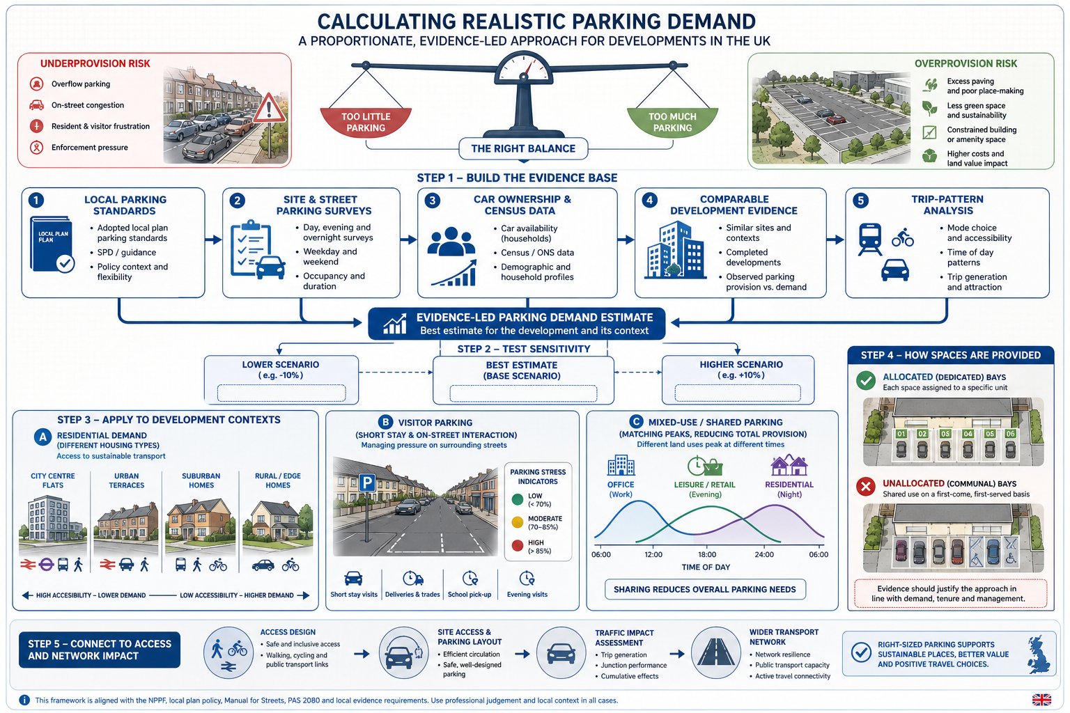
Overprovision can be just as problematic as underprovision. Too many spaces can dilute placemaking, increase impermeable surfacing, weaken active travel objectives and consume land that would be better used for landscape, amenity or floorspace. The challenge is to estimate likely demand with enough confidence that the parking offer feels realistic rather than defensive.
We usually start with local standards, then test them against empirical evidence. That can include survey data from the site context, car ownership information, Census or local demographic indicators, and comparable development evidence where it is genuinely comparable. Trip generation tools such as TRICS can help frame likely arrival patterns and peak interaction with the network, though parked demand should not be inferred mechanically from trips alone.
Sensitivity testing is useful here. Instead of presenting one rigid figure, it can be stronger to explain a central estimate, the assumptions behind it, and the circumstances under which demand could sit slightly higher or lower. That shows the authority that the strategy has been thought through rather than reverse-engineered.
On larger schemes, parking demand also needs to be read alongside broader network impact work. A coherent relationship between parking demand, access design and traffic impact assessment evidence gives the application much more resilience.
Residential Parking, Visitor Parking, And Mixed-Use Requirements
Residential parking calculations need more nuance than a flat ratio per unit. Unit size, tenure, affordability, urban form and local car ownership all influence likely demand. A city-centre apartment scheme near strong public transport may justify materially lower provision than suburban family housing, where multi-car households are more common.
Visitor parking deserves separate thought. Some authorities specify a distinct visitor allowance: others expect it to be embedded in the total supply. Either way, if visitors are likely to rely on surrounding streets, that should be tested honestly against baseline parking stress and local controls.
Mixed-use development is where the strategy can become more efficient. Different uses often peak at different times, opening the door to shared parking arrangements. Office demand may reduce in the evening just as leisure demand rises: residential visitor demand may be strongest when employment use is quiet. But shared use only works if the operational rules are clear and the peak-staggering is evidenced rather than assumed.
We also need to distinguish between allocated and unallocated spaces. Allocated bays can improve certainty for residents or occupiers, while unallocated stock can offer flexibility. The right balance depends on the management model, the user profile and the authority’s expectations.
Designing Layouts That Support Safety, Access, And Efficient Movement
A parking strategy is only persuasive if the layout works on the ground. That means dimensions, circulation and user experience matter just as much as the headline number of spaces.
Bay sizes and aisle widths should align with the applicable guidance and local standards, particularly where walls, columns or tight turning conditions affect usability. Spaces that are technically drawn but awkward to enter are unlikely to be accepted as genuine capacity. The same goes for tandem arrangements, heavily obstructed corners or parking that depends on repeated shuffling of vehicles.
Pedestrian movement often reveals whether a layout has been designed properly. People need obvious, safe routes from parked vehicles to building entrances, cycle stores and the public highway. Footways, crossing points, lighting, natural surveillance and step-free access are all part of parking quality, not extras.
Internal movement also needs to be legible. Drivers should understand where to go, where to turn, and where servicing or refuse activity takes priority. On larger schemes, zoning can help separate residential, visitor, staff and servicing functions so that one activity does not undermine another.
For developers, this is where deliverability comes sharply into focus. A good design team will test the layout early, because late-stage changes to parking geometry can ripple into landscape, drainage, servicing and unit configuration. That is why parking should sit within wider Private Sector Transport Planning rather than being treated as a final compliance exercise.
Blue Badge Parking, Cycle Parking, And Electric Vehicle Provision
Modern parking strategies need to cover more than standard car bays. Planning authorities increasingly expect a joined-up approach to inclusive access, active travel and the transition to lower-emission vehicles.
Blue Badge parking should be located where it is genuinely useful: close to principal entrances, step-free, clearly signed and designed to the required dimensions. It is not enough to include the right count if the spaces are remote, awkwardly graded or dependent on crossing active vehicle routes. Accessibility has to work in practice.
Cycle parking is now central to many applications, especially where car parking is restrained. The quality test is straightforward: can people access it easily, is it secure, weather-protected where needed, and suitable for the likely users? Resident cycle stores, visitor stands, larger spaces for adapted cycles or cargo bikes, and staff facilities can all become relevant depending on the use.
Electric vehicle provision is evolving quickly through local policy and Building Regulations. Most authorities now expect active charging in a proportion of spaces and passive provision or cabling capacity in others. The practical question is futureproofing. Retrofitting charging infrastructure later is often far more disruptive and expensive than planning for it from the start.
A balanced strategy treats these elements as part of one mobility offer. Lower car provision becomes much easier to defend when accessible spaces, cycle facilities and EV infrastructure are clearly and credibly addressed.
Managing Parking Through Allocation, Controls, And Travel Planning
The best parking strategy is not always the one with the most spaces. Often, it is the one with the clearest management plan.
Allocation can make a major difference. Reserving spaces for particular units, staff groups, disabled users, car club vehicles or short-stay visitors helps parking operate as intended. In some schemes, unallocated parking supports flexibility: in others, it creates uncertainty and inefficient use. The right approach depends on the development type and how tightly demand needs to be managed.
Controls may include permits, lease clauses, time limits, ANPR systems, waiting restrictions within private land or managed visitor booking arrangements. These are especially valuable where a site has limited parking but strong accessibility by non-car modes. If residents or occupiers understand the rules from the outset, conflict tends to reduce.
Travel Plans remain an important companion document. They show that parking restraint is not arbitrary but linked to real measures: public transport information, cycle incentives, car club membership, welcome packs, monitoring and review. For many applications, that wider package is what turns a marginal parking case into an acceptable one.
And where a scheme forms part of a larger phased proposal, parking management should evolve with occupation. A rigid strategy can date quickly. A monitored, reviewable approach is often more persuasive because it reflects how developments actually bed in over time.
Common Planning Objections And How To Strengthen Your Evidence Base
Most parking objections follow familiar themes: overspill onto nearby streets, increased congestion at the access, unsafe manoeuvring, conflict with pedestrians, inadequate visitor provision, or a claim that the scheme ignores local reality. Sometimes the opposite appears and objectors argue there is too much parking, undermining sustainability and design quality. Either way, vague assurances rarely work.
The strongest response is a transparent evidence base. That means clearly referenced policy analysis, survey methods that can withstand scrutiny, plans that show dimensions and tracking properly, and a demand calculation that explains assumptions rather than hiding them. Sensitivity tests help, especially where local concern is high. They show we have considered uncertainty rather than pretending it does not exist.
It also helps to anticipate likely criticism before submission. If neighbours are likely to raise overspill, include local parking stress analysis. If servicing looks tight, provide swept paths and operational commentary. If parking is below standard, explain accessibility, travel plan measures and management controls in one joined-up argument.
For applicants working to tight programmes, concise reporting matters too. Authorities respond better when evidence is easy to follow and tailored to local thresholds. That is a principle we apply across parking strategy for developments, transport statements and related planning support.
Above all, credibility comes from being proportionate and honest. A strategy that acknowledges site constraints and justifies its choices tends to travel further than one that claims every issue has magically disappeared.
Conclusion
A robust parking strategy for developments is really an exercise in balance. It has to satisfy policy, reflect local conditions, support safe and efficient design, and remain deliverable for the scheme that is actually being built. That means parking numbers alone are never enough. We need a clear line from policy and site context through to demand, layout, management and evidence.
In 2026, planning authorities are looking for exactly that joined-up thinking. They want to know that parking has been right-sized, that accessibility and sustainable travel have been properly considered, and that likely impacts on surrounding streets have been tested rather than assumed away.
When we approach parking strategically, objections become easier to answer and design decisions become easier to defend. For architects, planners, developers and councils, that makes parking less of a late-stage problem and more of a practical planning tool. And usually, that is what keeps an application moving.
Frequently Asked Questions about Parking Strategy for Developments
What key elements must a parking strategy address in a UK planning application?
A parking strategy must demonstrate compliance with the National Planning Policy Framework and local plans, justify parking provision with local evidence, ensure no severe impact on highway safety or parking stress, and support sustainable travel and accessibility.
How do local policies and site context influence parking provision in developments?
Local policies set standards often by use class and location, with town-centre or high-accessibility sites justifying lower car parking and emphasizing cycle or electric vehicle parking. The site context, including transport links and local constraints, shapes the final provision.
Why is understanding end users and trip patterns important for parking demand calculations?
Different development uses have distinct parking demands based on occupancy, shift patterns, visitor activity, and car ownership. Knowing these helps create realistic parking strategies that fit user behaviour and avoid over- or under-provision.
How can design and management improve the effectiveness of parking in new developments?
Well-designed layouts ensure safe, accessible parking with appropriate bay sizes and pedestrian routes. Management through allocation, permits, and travel plans helps regulate demand, supports modal shift, and reduces conflicts and overspill.
What role do sustainable travel and accessibility play in modern parking strategies?
Modern strategies integrate Blue Badge spaces, cycle parking, and electric vehicle charging to promote inclusivity and reduce car dependency, aligning parking provision with policies encouraging active travel and emissions reduction.
How can developers address common planning objections related to parking?
By providing transparent, proportionate evidence such as parking surveys, impact assessments, swept paths, and sensitivity testing, developers can demonstrate policy compliance, mitigate overspill concerns, and show that parking is well planned and manageable.